Mini Miler
Bald Eagle - Pilot Ridge Loop
August 1994
by Cascade Bill Mooseker
(Revised March 2025)
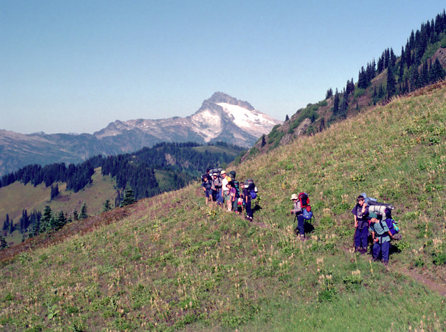
Sloan Peak from Pilot Ridge
Adults on this trip:
Bill Mooseker, Greg Phillips, Steve Abbott
Scouts on this trip:
Adam Phillips, Matthew Perry, Matthew Demers, Arlo Abbott, Andrew Mooseker, Kyle Meissner, Kevin Funston, Danny Stallings, Cary Walker
This was the first major hike for a bunch of first and second year scouts. It was a rugged hike,
and even though it was billed as a "Mini-Miler", they were tough miles. The troop committee didn’t want to let us do the hike as they said there wasn’t enough time to properly plan it as their older scouts were going on a “100 miler” hike that they had taken all year to plan. I told them that in my previous stint at Troop 24 I had planned and led many Mini-Miler as well as 50 Miler trips. I had the maps, the menus, and the experience to know how to plan each day’s route, and how to organize it effectively.
I have prepared a Caltopo map for this trip that can be found HERE. You can export a Google "KML" to display on Google Earth or a "GPX" file that can be transferred to a handheld GPS device"
The descriptions under the photo thumbnails in the album sometimes contain links to maps or additional information. These are identified by "Blue” text for links.
Troop 24 "The High Adventure Troop" Backpacking Trip
-Cascade Bill Mooseker
Date(s): August 1994. Album by Cascade Bill. 1 - 60 of 60 Total. 714 Visits.
enlarge 354KB, 1024x702 1 pics 1
To enlarge photos, click on the thumbnail - the photo will pop up enlarged to 1024 pixels max (height or width). To view at Original size (best for maps, etc.), Ctrl-Click on the Photo, and finally a 3rd click to enlarge to the original resolution. Click again to reduce back to fit the screen again.
If you want to save photos to your computer, click the box under the thumbnails of all the photos you want to download (or check the "select all" box at the bottom of the album). Then click the "Download" button at the top of the album. Pick the size you'd like to download (Original is best)and the photos will be downloaded as a zip file to the folder of your choice.
enlarge 4.54MB, 791x1024 2 1994 Mini Miler Update.pdf To Open: Click on thumbnail. Then click on the "Open this PDF"
Because this would be the first multi-day backpacking trip they would be attending, I wrote this guide explaining what to expect. Some things did not work out as planned. The proposed organization of cooking groups was a disaster for a bunch of boys that had never used a backpacking stove or freeze dried food. Also I was a little optimistic about our route. We didn't make it to the Upper Blue Lake, nor did we climb Johnson Mtn. In retrospect we were lucky to find water for or first and last night's camps.
enlarge 148KB, 1024x961 3 94 nicknames
enlarge 71KB, 1152x463 4 Summary Stats
Summary of the stats for this hike by day and cumulatively for each day. These were calculated recently (March 2025) using routes plotted from Caltopo maps by the method described HERE
In hindsight, this trip was probably too difficult for these young scouts, but they did very well. In the introduction above, I referenced a "100 Miler" trip that the older scouts were going on. As a measure of difficulty, the "100 Miler" had about 16000 feet of elevation gain as compared to the 7500 feet for the "Mini" Miler in a quarter of the distance
enlarge 351KB, 759x1024 5 94mm-d1 Caltopo Map for Day 1
I had hiked portions of this route previously in 1975, 1979, and 1985. Back then the trailhead was accessible by road to about 3000 ft elevation. Unfortunately, the bridge over Sloan Cr. was washed out and you now started at elevation 2400 ft. It was a long, dry, and fairly boring hike with few vistas available. Our goal was when the trail neared the ridge, we would scramble over the ridge and camp in the basin on the other side, where we hoped there was water.
Well we did find water but it was about 200 feet (elevation) below our camping spot. Greg Phillips and I each used our packs to carry a loaded 5 gal Reliance jug back up to camp (about 42 lbs). It was the first trip for my Sierra Designs Clip 3 tent, supposedly designed for 3 persons, but we had 4 eleven yr old scouts crammed into it. Because of fire danger, no fires were allowed so we had a "campfire" around a couple of candle lanterns telling scary stories before we went to bed...
enlarge 142KB, 1152x701 6 Day 1 Stats
Here are the stats for Day 1. With over 2700 feet of elevation gain, this was the most difficult day of the trip by far when you consider that packs are heaviest at the beginning of a trip. Waypoints correspond to those shown on the map.
The first night's meal was a disaster - the boys didn't have any experience with the stoves. I had broken them up into different cooking groups and I was running around like a chicken with it's head cut off. And nobody like the main course: Cheese Enchilada Ranchero and I had to bury a lot of it.
enlarge 505KB, 1024x670 7 94-237-017
Adam Phillips and Matt Perry followed by the group. This is the old road portion of the trail, which you can see has really become brushed in over the years. Although we did a pretty rigorous pack check prior to the hike, we did not check the scouts snacks. Climbing up the trail,Matt Demers was having a hard time and when we checked his pack we found about 5 lbs of candy. Greg distributed the bulk of it to the others
I regret not taking any photos in camp that first night, but it was stressful getting camp set up, dinner prepared, and cleaned up with a bunch of inexperienced young scouts.
enlarge 377KB, 1152x680 8 94mm-d2 Caltopo Map for Day 2
Generally, the trail follows the ridge with a lot of ups and downs past Bald Eagle Mtn, Long John Mtn and June Mtn before it descends into the Blue Lakes Basin.
enlarge 231KB, 931x1024 9 Day 2 Stats
Stats for Day 2 - A pretty long day with a lot of ups and downs but with a lot of glorious views in all directions. Just after June Mtn, we left the Bald Eagle Trail and followed the Pilot Ridge Trail to our Camp near the Lower Blue Lake.
enlarge 559KB, 1024x670 10 94-237-019
Crossing a high meadow: Cary Walker, Danny Stallings, (Kyle Meissner), Andrew Mooseker, Matt Perry, Kevin Funston, Adam Phillips, Matt Demers, and Greg Phillips.
enlarge 278KB, 1024x666 11 94-237-020 Taking a break near Bald Mtn Adam, Greg, Matt D, Andrew, Matt P, Danny, Kyle, Cary
enlarge 372KB, 670x1024 12 94-237-021 Another view
enlarge 287KB, 670x1024 13 94-237-022
Looking down the valley from the saddle below Bald Mtn to Glacier Peak in the far distance. Across the way is Pilot Ridge where we will be two days later.
enlarge 449KB, 1024x671 14 94-237-023
Taking a break in the saddle below Bald Mtn: Andrew, Adam, Greg, Matt P, Kevin, Matt D, Kyle, Danny, and Cary. (You can see why Kevin got the nickname "Hi-Rise" because his pack extended so far above his head)
enlarge 320KB, 674x1024 15 94-237-024 On the Pilot Ridge Trail descending towards the Blue Lakes Basin
enlarge 390KB, 1024x670 16 94-237-025
Descending Switchbacks: Arlo, Steve, Kevin, Kyle, Andrew, Danny, Cary, Greg, Matt P, Adam, and Matt D. If you enlarge the photo, you can see why Greg got the name Packhorse Phillips. Matt D was having a hard time so Greg strapped Matt's pack on top of his.
enlarge 367KB, 644x1024 17 94mm-d3 Caltopo Map for Day 3
A pretty easy day - only 2.8 miles climbing up out of the Blue Lakes Basin up to Pilot Ridge. It would have been a long trip out to the cars from Camp 2 so I found a potential camp site off the trail along Pilot Ridge.
enlarge 149KB, 1024x711 18 Day 3 Stats
Stats for Day 3 - We took it easy along Pilot Ridge. We cut off the trail up to a saddle along the ridge that I thought had potential for a campsite. In the saddle there was a small snowmelt pond, with about the scuzziest water you've ever seen, but "Beggars can't be choosers".
enlarge 443KB, 1024x673 19 94-238-002 Small Pond below our Campsite Bill, Kyle, Andrew, Matt P, Kevin, Arlo, Matt D, Steve, Cary, Danny
enlarge 417KB, 1024x672 20 94-238-000 Another view -except Greg replaces Bill
enlarge 505KB, 1024x673 21 94-238-003
Heading out along the climb to Pilot Ridge - This is close to the junction with the trail that goes to the Upper Blue Lake.
enlarge 319KB, 673x1024 22 94-238-004 Looking back we can see the Lower Blue Lake below the mists
enlarge 383KB, 1024x671 23 94-238-005 Almost to the ridge top
enlarge 344KB, 1024x672 24 94-238-006
Looking back to Bald Eagle Ridge - June Mtn is the high point to the left. If you enlarge the photo (original size is best) you can see the Bald Eagle Trail as it crosses the face of June Mtn. The Pilot Ridge Trail is also seen above the 2nd talus slope at the bottom left.
enlarge 359KB, 679x1024 25 94-238-007 Lower Blue Lake from higher along the trail
enlarge 295KB, 1024x675 26 94-238-008 Looking west from just below the ridge - the Monte Cristo Peaks are shrouded in clouds
enlarge 247KB, 1024x665 27 94-238-009
Looking towards the Monte Christo Peaks from near the waypoint: B19 HP 6080 (see map for Day 3)
enlarge 311KB, 678x1024 28 94-238-011
Looking towards Sloan Peak whose summit is in the clouds. This is the basin just west of Johnson Peak. The meadow at the center is on the extension of Pilot Ridge, which we will traverse tomorrow
enlarge 344KB, 1024x671 29 94-238-010 Having Lunch - Steve, Matt D, Greg, Andrew, Arlo You can see Bald Eagle Ridge in the background
enlarge 343KB, 1024x672 30 94-238-012 Adam, Danny, and Kevin
enlarge 255KB, 1024x676 31 94-238-013 Andrew - June Mtn in the background
enlarge 324KB, 1024x674 32 94-238-016 Relaxing after Lunch with the cloud covered Monte Cristo Peaks in the background Kyle, Kevin, Danny, Cary, Andrew, Arlo, Matt P, Adam, Greg, Matt D, Bill
enlarge 348KB, 1024x672 33 94-238-017 Getting ready to get back on the trail
enlarge 324KB, 671x1024 34 94-238-018 The trail winds around the basin
enlarge 427KB, 1024x676 35 94-238-020 With Sloan Peak in the clouds, Kyle, Steve, Arlo, and Andrew continue along the Pilot Ridge trail
enlarge 220KB, 1024x674 36 94-238-021 The scouts are strung out along the trail as it traverses a steep meadow along Pilot Ridge
enlarge 345KB, 680x1024 37 94-238-022
Setting up camp at the saddle on Pilot Ridge that used to be an old Sheepherder's camp. The good news is that we found water - the bad news was the it was pretty scuzzy. Although we had a filter, we prefiltered the water by pouring it through a tee shirt.
enlarge 285KB, 1024x665 38 94-238-023 Looking east from the saddle
enlarge 248KB, 1024x674 39 94-238-024 Steve and Arlo having some Dad and Son time
enlarge 283KB, 1024x665 40 94-238-025 Looking SE from the saddle - looks like clear skies that way
enlarge 338KB, 1024x672 41 94-238-026
Johnson Mtn - If you enlarge the photo to original size you can see the trail in spots as it goes along the ridge
enlarge 245KB, 675x1024 42 94-238-027 Looking east the views are limited due to the low clouds
enlarge 254KB, 1024x672 43 94-238-028 Looking back towards June Mtn before sunset
enlarge 264KB, 1024x670 44 94-238-029 Arlo
enlarge 314KB, 1024x684 45 94-238-030 Looking North along Pilot Ridge
enlarge 317KB, 1024x678 46 94-238-031 The trail is about 200 ft below the saddle
enlarge 324KB, 1024x680 47 94-238-032
Dinner time: It was the 3rd (and final) night of our trip and the boys were getting better at preparing dinner
enlarge 343KB, 1024x674 48 94-238-033 Andrew & Kyle are cooking the chili. The MSR Firefly stoves are roaring away.
enlarge 258KB, 680x1024 49 94-238-034 Andrew stirring the pot as Kyle supervises
enlarge 279KB, 1024x678 50 94-238-035 Suppertime: Greg, Steve, Danny, Matt D, Kevin, Adam, Andrew, Cary, Kyle, and Matt P You can see the old fireplace hasn't been used in a long time
enlarge 225KB, 1024x675 51 94-238-036
For a while there, I thought that we were going to have a downpour as it got very dark as the sun peeks through
enlarge 317KB, 1024x675 52 94mm-d4 Caltopo Map for Day 4 It was a long day but you were glad that you weren't coming up that hill
enlarge 232KB, 1024x991 53 Day 4 Stats
Stats for Day 4 - About 4.5 miles of ridge walking with many ups and downs before a long 2.5 mile descent to connect with the White Pass Trail and a short valley pound to the trailhead.
enlarge 317KB, 1024x670 54 94-239-001 Adam and Andrew The clouds had disappeared and Glacier Peak was visible
enlarge 332KB, 1024x671 55 94-239-002 View from our camp
enlarge 336KB, 1024x667 56 94-239-003 The Monte Cristo Peaks without their cloud cover are spectacular
enlarge 408KB, 1024x672 57 94-239-004 Adam and Andrew getting their packs ready for the trip out
enlarge 391KB, 1024x767 58 94-239-005 Andrew with Long John Mtn at top right
enlarge 410KB, 1024x764 59 94-239-006 Rounding a shoulder on the ridge we get a great view of Sloan Peak without the clouds
Kyle got his nickname, "Let's Make a Deal" because on our last day, Greg said he was going to get rid of his tent. Kyle persuaded Greg to give the tent to him, which Greg did with the provision that Kyle would carry it out. I don't know how many times Kyle repeated on the way out, "I made a good deal, didn't I". If you enlarge to "original" size, you can see the tent strapped on top of his pack (Kyle is last in line).
enlarge 290KB, 1024x727 60 2025-03-31 19-16-29 - 94-001 Bill and Adam crossing the N Fork of the Sauk River on a convenient log