1.
2016 Trip WA to UT (May 6-7, 2017)
|
|
On the Road
Washington to Kane Gulch
with Bill, Shelby, Mike & Madison
May 6 & 7, 2016
|
|
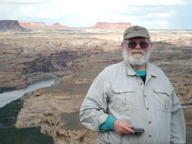
Bill at Hite Overlook
|
|
It's a long two day drive from Washington to the Kane Gulch Ranger Station. Ours was a little longer as we made a detour to a Chevron station in Rainer, Oregon so Shelby could get some surplus 50cal ammo. We got in very late to our usual stop, the Marble Motel in Tremonton, Utah, but they were very good about getting us in our room after hours.
On our 2nd day, Shelby & I met up with Mike and his daughter Madison at the Salt Lake REI, where we picked up last minute supplies and Shelby bought a Big Agnes Copper Spur UL 3 man mtnGLO Tent (3lbs 12oz) for Fred & Cindy to use on the trip.
The descriptions under the photo thumbnails in the album sometimes contain links to maps or additional information. These are identified by "Blue” text for links. I've also inserted links to Google Maps to show where certain photos in the album were taken or to locate features shown in the photos. Click on the link, close the sidebar, and choose satellite view. Basically, you can then zoom in and out using the mouse wheel or drag the map by clicking and holding.
For panoramic photos, I would recommend clicking on the thumbnail photo to enlarge. View at original size for most detail. The thumbnails do not do justice to petroglyphs and pictographs, so I would recommend enlarging them as well. Please take the time to view the many videos to better experience what it was like to be there.
|
Troop 24 Kickass Trekkers Backpacking Trip
-Cascade Bill Mooseker
|
| 1593 Visits, 35 Items, Shared Album |
|
| 2.
2016 Trip NM to UT (May 7, 2016)
|
|
On the Road
Tularosa, NM to Kane Gulch
with Fred & Cindy
May 7, 2016
|
|
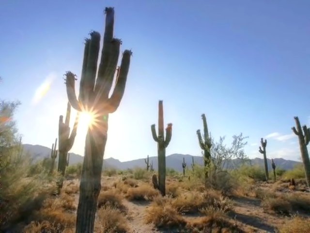
Saguaro Cacti
|
|
The descriptions under the photo thumbnails in the album sometimes contain links to maps or additional information. These are identified by "Blue” text for links. I've also inserted links to Google Maps to show where certain photos in the album were taken or to locate features shown in the photos. Click on the link, close the sidebar, and choose satellite view. Basically, you can then zoom in and out using the mouse wheel or drag the map by clicking and holding.
For panoramic photos, I would recommend clicking on the thumbnail photo to enlarge. View at original size for most detail. The thumbnails do not do justice to petroglyphs and pictographs, so I would recommend enlarging them as well. Please take the time to view the many videos to better experience what it was like to be there.
|
Troop 24 Kickass Trekkers Backpacking Trip
-Cascade Bill Mooseker
|
| 777 Visits, 21 Items, Shared Album |
|
| 3.
2016 Grand Gulch Day 1 (May 8, 2016)
|
|
Grand Gulch 2016
Day 1 - May 8
Kane Gulch to Todie Canyon
|
|
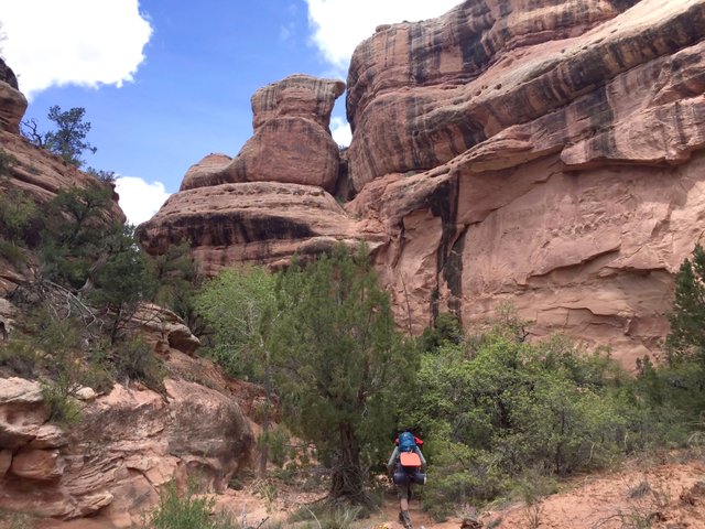
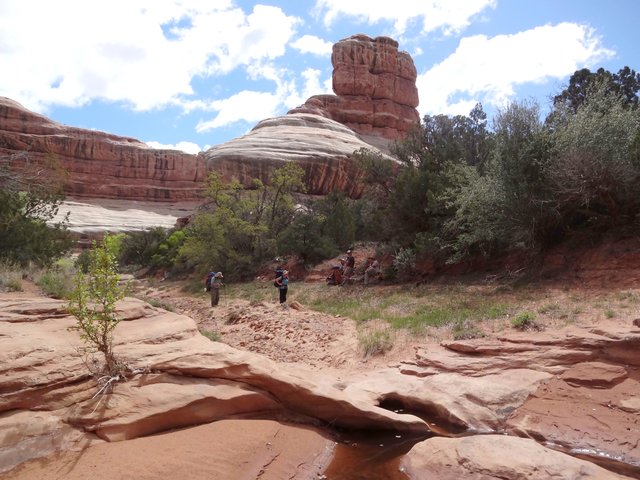
Taking a Break in Kane Gulch
|
|
It's hard to get an early start for a hike in Grand Gulch, as you have to pick up your permit at the Kane Gulch Ranger Station, which opens at 8:00 AM and closes at noon. In addition you have to watch an instructional video about Grand Gulch before venturing out.
After watching the video, Fred, Cindy, and Shelby took off on the required car shuttle so that we would have a vehicle when we exited the canyon at the Government Trailhead. In the meantime, Mike, Madison, and I got the gear sorted out into piles and got our packs ready to go.
When Shelby and the rest returned, we got all the gear packed and we headed out. Day one is very scenic and interesting. You start out on the mesa top and gradually drop into Kane Gulch. After reaching the junction with the main canyon, there seems to be ruins at every turn.
We made our camp at the mouth of Todie Canyon, which is about 7.2 miles from the ranger station. I did a couple of miles more as I headed back up Kane Gulch by mistake instead of heading down canyon. All in all it was a good day.
Note photo takers are given in the titles under the thumbnails.
Kickass Trekkers on this trip were: Bill Mooseker, Shelby Stong, Mike Stong, Madison Stong, Fred Stong, and Cindy Stong.
The descriptions under the photo thumbnails in the album sometimes contain links to maps or additional information. These are identified by "Blue” text for links. I've also inserted links to Google Maps to show where certain photos in the album were taken or to locate features shown in the photos. Click on the link, close the sidebar, and choose satellite view. Basically, you can then zoom in and out using the mouse wheel or drag the map by clicking and holding.
For panoramic photos, I would recommend clicking on the thumbnail photo to enlarge. View at original size for most detail. The thumbnails do not do justice to petroglyphs and pictographs, so I would recommend enlarging them as well. Please take the time to view the many videos to better experience what it was like to be there.
|
Troop 24 Kickass Trekkers Backpacking Trip
-Cascade Bill Mooseker
|
| 9979 Visits, 175 Items, Shared Album |
|
| 4.
2016 Grand Gulch Day 2 (May 9)
|
|
Grand Gulch 2016
Day 2 - May 9
Todie Canyon to Sheiks Canyon
|
|
Ready to Go - Near Big Pouroff Pool
|
|
It was a great day for hiking on our second day down Grand Gulch. Our campsite at the mouth of Todie Canyon caught the early rays of the sun, and we got off to an early (well for us anyway) start.
This was probably the best day on the hike. There wasn't too much bushwhacking through brush and climbing in and out of the wash. In addition the scenery was spectacular, which included the wonderful Split Level ruin.
We made our second camp in Sheik's Canyon after hiking 7.2 miles for the day. We ended our day listening to the chorus of frogs in the Green Mask spring.
Note photo takers are given in the titles under the thumbnails.
Kickass Trekkers on this trip were: Bill Mooseker, Shelby Stong, Mike Stong, Madison Stong, Fred Stong, and Cindy Stong.
The descriptions under the photo thumbnails in the album sometimes contain links to maps or additional information. These are identified by "Blue” text for links. I've also inserted links to Google Maps to show where certain photos in the album were taken or to locate features shown in the photos. Click on the link, close the sidebar, and choose satellite view. Basically, you can then zoom in and out using the mouse wheel or drag the map by clicking and holding.
For panoramic photos, I would recommend clicking on the thumbnail photo to enlarge. View at original size for most detail. The thumbnails do not do justice to petroglyphs and pictographs, so I would recommend enlarging them as well. Please take the time to view the many videos to better experience what it was like to be there.
|
Troop 24 Kickass Trekkers Backpacking Trip
-Cascade Bill Mooseker
|
| 7664 Visits, 211 Items, Shared Album |
|
| 5.
2016 Grand Gulch Day 3 (May 10)
|
|
Grand Gulch 2016
Day 3 - May 10
Sheiks Canyon to Step Canyon
|
|
Climbing out of the Wash
|
|
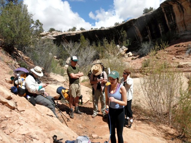
The day began with a extensive exploration of the pictographs at the Green Mask Panel. This panel is remarkable in that it features many different styles of art located in close proximity. The Green Mask itself is a little underwhelming, when you finally find it but then you wonder how someone could have gotten up there to paint it.
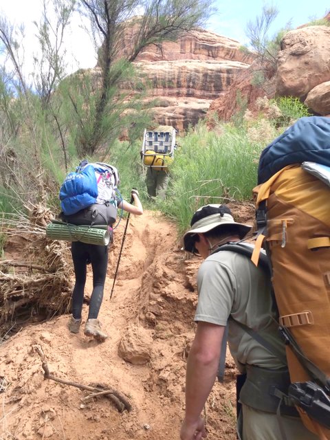
After the reasonably easy hiking of the previous day, things change as you get close to the junction with Bullet Canyon. Lush vegetation obscures the vague trails, and the banks of the wash get steeper and deeper. This makes the many times you have to get in and out of the wash very tiring, especially for an overweight 72 year old. I wasn't the only one either, as no one wanted to climb up to the Two Story ruin.
We camped at the mouth of Step Canyon. Unlike our two previous camps, the water situation was pretty grim and took much exploring to find a good pool. Offsetting that, was the fabulous Quail Panel. Even though we only covered 5.5 miles for the day, almost 2 miles less than the previous days, we all agreed that it was the hardest day of the trip.
Note photo takers are given in the titles under the thumbnails.
Kickass Trekkers on this trip were: Bill Mooseker, Shelby Stong, Mike Stong, Madison Stong, Fred Stong, and Cindy Stong.
The descriptions under the photo thumbnails in the album sometimes contain links to maps or additional information. These are identified by "Blue” text for links. I've also inserted links to Google Maps to show where certain photos in the album were taken or to locate features shown in the photos. Click on the link, close the sidebar, and choose satellite view. Basically, you can then zoom in and out using the mouse wheel or drag the map by clicking and holding.
For panoramic photos, I would recommend clicking on the thumbnail photo to enlarge. View at original size for most detail. The thumbnails do not do justice to petroglyphs and pictographs, so I would recommend enlarging them as well. Please take the time to view the many videos to better experience what it was like to be there.
|
Troop 24 Kickass Trekkers Backpacking Trip
-Cascade Bill Mooseker
|
| 5033 Visits, 133 Items, Shared Album |
|
| 6.
2016 Grand Gulch Day 4 (May 11)
|
|
Grand Gulch 2016
Day 4 - May 11
Step Canyon to Pollys Canyon
|
|
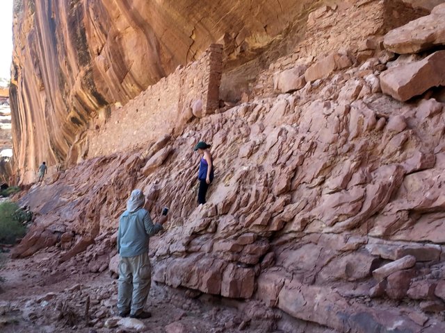
Long House Ruin
|
|
Continuing on down Grand Gulch from Step Canyon, the going got a little easier than the death march of the previous day. Highlights of the day included exploring the Long House ruin, as well as the Big Man and Dead Spar Knoll pictograph panels.
Our fourth camp was at Polly's Canyon in a grove of giant cottonwoods. Unlike the previous camp, there was a large pool of water at the mouth of Polly's. Mileage for the day was 6.7 miles.
Note photo takers are given in the titles under the thumbnails.
Kickass Trekkers on this trip were: Bill Mooseker, Shelby Stong, Mike Stong, Madison Stong, Fred Stong, and Cindy Stong.
The descriptions under the photo thumbnails in the album sometimes contain links to maps or additional information. These are identified by "Blue” text for links. I've also inserted links to Google Maps to show where certain photos in the album were taken or to locate features shown in the photos. Click on the link, close the sidebar, and choose satellite view. Basically, you can then zoom in and out using the mouse wheel or drag the map by clicking and holding.
For panoramic photos, I would recommend clicking on the thumbnail photo to enlarge. View at original size for most detail. The thumbnails do not do justice to petroglyphs and pictographs, so I would recommend enlarging them as well. Please take the time to view the many videos to better experience what it was like to be there.
|
Troop 24 Kickass Trekkers Backpacking Trip
-Cascade Bill Mooseker
|
| 8859 Visits, 160 Items, Shared Album |
|
| 7.
2016 Grand Gulch Day 5 (May 12)
|
|
Grand Gulch 2016
Day 5 - May 12
Polly's Canyon to Goverment Trailhead
|
|
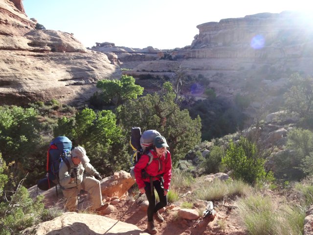
Climbing Out of Grand Gulch via the Government Trail
|
|
Our last day on the trail was only about 3 miles from Polly's Canyon to the Government Trailhead, but it included a 500 foot climb up to the rim. The Government Trail starts a short ways down canyon from our camp. As it climbs out or the canyon, the views become ever more spectacular.
After you reach the rim, the trail crosses the mesa leaving all visual evidence that Grand Gulch even exists. With far away views of the Bear's Ears and other tall mesas, we finally reach the stockpond that marks the trailhead. We all piled into Shelby's truck and made our way back to the Kane Gulch Ranger station where we said our goodbyes to Fred and Cindy.
Heading north, we stopped in Blanding for lunch and after dropping Mike and Madison off in Salt Lake, Shelby and I continued on to Mountain Home, Idaho where we found a motel for the night.
Note photo takers are given in the titles under the thumbnails.
Kickass Trekkers on this trip were: Bill Mooseker, Shelby Stong, Mike Stong, Madison Stong, Fred Stong, and Cindy Stong.
The descriptions under the photo thumbnails in the album sometimes contain links to maps or additional information. These are identified by "Blue” text for links. I've also inserted links to Google Maps to show where certain photos in the album were taken or to locate features shown in the photos. Click on the link, close the sidebar, and choose satellite view. Basically, you can then zoom in and out using the mouse wheel or drag the map by clicking and holding.
For panoramic photos, I would recommend clicking on the thumbnail photo to enlarge. View at original size for most detail. The thumbnails do not do justice to petroglyphs and pictographs, so I would recommend enlarging them as well. Please take the time to view the many videos to better experience what it was like to be there.
|
Troop 24 Kickass Trekkers Backpacking Trip
-Cascade Bill Mooseker
|
| 2993 Visits, 95 Items, Shared Album |
|
| |