Adults on this trip:
Merl Weatherhogge,Bill Mooseker
Scouts on this trip:
Scott Weatherhogge,Dave Burgess,Wade McDaniel,David Longfellow,Wayne Leer,
Greg Mooseker,Matt Guentz
Forced to change our plans due to an ash cloud from Mt St. Helens, we headed to the rugged Pasayten Wilderness as an
alternate destination. It was a great trip to some of the most beautiful backcountry ridge walking anywhere. If only you
didn't have to climb almost 4000 feet in a day to get to it.
The descriptions under the photo thumbnails in the album sometimes contain links to maps or additional information. These are identified by "Blue” text for links.
Troop 24 "The High Adventure Troop" Backpacking Trip
-Cascade Bill Mooseker
Date(s): August 1980. Album by Cascade Bill. 1 - 46 of 46 Total. 4763 Visits.
enlarge 354KB, 1024x702 1 pics 1
To enlarge photos, click on the thumbnail - the photo will pop up enlarged to 1024 pixels max (height or width). To view at Original size, just click on the enlarged photo, which will show the photo enlarged to fit the screen. Click on the screen to enlarge that portion of the photo at original resolution. Click again to reduce.
If you want to save photos to your computer, click the box under the thumbnails of all the photos you want to download. Then click the "Download" button at the top of the album. Pick the size you'd like to download (Original is best)and the photos will be downloaded as a zip file to the folder of your choice.
enlarge 344KB, 1024x802 2 80dev01a
This is the handout for the 1980 Fifty Milers. This was the second of my 50 Miler Scout trips. The troop had two trips planned because of the number of boys that wanted to go. Group 1 (My group) was going to do a backpacking trip in the Glacier Peak Wilderness leaving from the Phelps Creek (Spider Meadow) trailhead. Group 2 was going to do a combined backpacking/canoe trip along Ross Lake.
Mount St Helens had other plans for our trip, and when we got to the trailhead, the air was filled with ash from one of the many eruptions that summer. So we turned around and headed back home, where I hastily put together another trip to leave the next day.
enlarge 393KB, 1024x910 3 80dev02 Troop Rules and Regulations.
enlarge 375KB, 794x1024 4 80dev03
Menus for the trip: Ham Romanoff, Beef Stroganoff, and Chicken and Dumplings were prepackaged freeze dried food. Rice dinners were instant rice mixed with freeze dried ham, chicken, and beef. We also mixed cocoa powder with dried milk to make our morning cocoa.
A lot of the deserts were stewed fruit. Merl didn't much care for this: "While I don't mind being regular, I don't want to be frequent". Over the years, my menu has changed - Click Here for a 2012 menu for a similar trip.
Today, only Chicken and Dumplings are still on the menu. Labor intensive menu items are gone. Lunches are not cooked (saves a lot of time), and breakfasts are either oatmeal or cereal. Pancakes for a large group are a disaster, and the dried egg dishes leave a bad aftertaste that lasts all day.
enlarge 362KB, 1024x662 5 CRATER MT p001
After consulting the guide books, I decided that we would do the Crater Devil's loop near Ross Lake. This was well away from the St. Helens ash cloud.
This is a map of Day one of our trip. (Note the proposed N cascades highway route is incorrectly placed!!!). We parked our cars at the East Bank Ross Lake Trailhead and descended to the Ruby Cr Trail.
Today there is a parking area and trail to abridge crossing Canyon Cr, that would have saved the long and boring trek up Ruby Creek. Climbing the steep trail to Camp 1 was very hard: Merl had terrible cramps and even the older boys were pooped.
Totals for Day 1: 6 miles and 3470' climbed.
enlarge 365KB, 1024x662 6 CRATER MT p002
For our 2nd day, we stashed our packs and took a side trip on Crater Mtn. Most of the group decided to hang out at small Crater Lake while Merl,Scott, Greg, and I decided to trek up to the site of the old lookout.
After we got back to our packs we continued on the trail through McMillan Park and climbed up to Devil's park and camped out near the old shelter there.
Totals for Day 2 (Bill/Merl/Scott/Greg): 7.5 miles & 3140' climbed.
enlarge 230KB, 1024x669 7 80-085-001
Bill & Scott taking break along the trail up to the old lookout. You can see the North Cascades Hwy going up the valley to the left of center.
enlarge 287KB, 1024x667 8 80-085-003 Jack Mtn.
enlarge 289KB, 1024x675 9 80-085-004 Scott and Bill.
enlarge 302KB, 1024x667 10 80-084-010 Greg and Scott.
enlarge 393KB, 677x1024 11 80-084-011
Scott & Greg at the end of the Lookout trail. Jack Mtn is very impressive.
enlarge 340KB, 1024x672 12 80-084-012
Scott and Greg looking down at the snowfields and little lakes at the foot of Crater Mtn.
enlarge 344KB, 662x1024 13 CRATER MT p003
Day 3 was a long day of ridge walking with a lot of up and downs.
One of the things that I did back then was have each person bake a treat that we would have as a snack at one of our breaks. Dave Burgess's treat was "Gluten Balls" for which he took a lot of ribbing as they looked just like the "horse apples" we found along the trail.
enlarge 245KB, 1024x669 14 80-085-006
Scott and Bill at break along the trail above Devils Park. (Wayne's hat at upper right). Merl's pack is behind Scott. Note that this was before water filters, as my cup attests. You would just drink from any running water along the trail (I'll still do that if there is no camping above.)
enlarge 288KB, 1024x670 15 80-085-005
Looking back towards Crater Mtn (on the left) and Jack Mtn (on the right).
enlarge 279KB, 1024x673 16 80-084-013
Crater Mtn from trail. You can see where we had hiked the day before.
enlarge 334KB, 662x1024 17 CRATER MT p004 Day 3 from Jackita to Devil's Pass.
Totals for Day 3: 8.7 miles & 2890' climbed.
enlarge 297KB, 1024x670 18 80-085-007
Jackita Mtn. You can see the trail switchbacking down the talus below.
enlarge 254KB, 1024x669 19 80-085-008
Looking north you can see Devil's Dome at the center of the picture.
enlarge 147KB, 1152x398 20 jackita-devils dome
A composite photo from the two previous pictures, showing Devil's Dome to the left and Jackita to the right.
enlarge 326KB, 1024x672 21 80-084-014 Taking a break: Scott, Matt, Merl, Wayne, and David.
enlarge 283KB, 1024x708 22 80-085-010 Merl, Matt, Wayne, and Wade.
enlarge 373KB, 1024x667 23 80-084-015
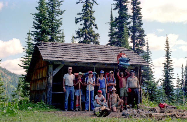
Camp 3 was at the Devil's Pass Shelter. This was a great camp as the shelter had a stove that kept it nice and comfy.
We had a great night with the added attraction of the Perseid Meteor Shower, which was spectacular in the wilderness sky of the Pasayten.
Unfortunately, the shelter has collapsed in the intervening years. Click here for a photo of the shelter as it exists today.
enlarge 340KB, 1024x667 24 80-084-016
Standing: Merl, Scott, Dave B., Wade, Dave L., Wayne, Bill
Kneeling: Greg, Matt.
The shelter is located about 200' below the ridge. In the late afternoon, Wade was up on the ridge and he found a big rock that he wanted to roll down the hill (what is it about scout age boys and their penchant for rolling rocks down hills??). I yelled, "Wade, Don't you dare do it!!!". The guys all yelled back, "Wade, Do it! Do It". Well, Wade listened to his inner boy scout and rolled the rock down the hill. Fortunately it missed the shelter.
enlarge 300KB, 1024x662 25 CRATER MT p005
Day 4: We Left the Crater-Devils Loop and headed east towards Sky Pilot Pass. As we hit Sky Pilot Pass, we met a couple heading south. The guy had a huge tent atop his pack. One of our guys asked him why he had such a big tent for just two people, he replied that he hated to be cooped up in a small tent on a rainy day with nothing to do.
As they hiked out of sight, one of the guys said, "with a babe like that I'd find something to do". I think that we all were thinking the same thing.
Totals for Day 4: 6.6 miles & 1615' climbed.
enlarge 328KB, 662x1024 26 CRATER MT p006
Day 4 continued: We found a nice basin to camp in. At first the guys spread their tents out, but when some large bear scat was found, they all moved them together in a group.
It was an eventful evening, as after the guys were playing Kick the Can, we found that Matt had disappeared. We yelled and yelled and I was close to panic as it was getting dark. Wayne and Dave went down the trail and finally found Matt, who had almost made it to the valley bottom.
The next day was a rest day in camp. While the rest of the guys stayed in camp, I did a day hike out towards Holman Pass and then north on the Cascade Crest Trail to Woody Pass.
enlarge 357KB, 1024x671 27 80-084-017
Photo from my day hike along the Cascade Crest Trail. Powder Mtn to the left of center. Rock Pass is just to the right of Powder.
Totals for my day hike: 12.8 miles and 3489' climbed.
enlarge 291KB, 673x1024 28 80-084-018 Another view. Unusual clouds
enlarge 270KB, 1024x679 29 80-084-019 Looking south towards Windy Pass from the Cascade Crest Trail.
enlarge 350KB, 671x1024 30 80-084-020
Day 6: Heading back to Devil's Pass. Descenting switchbacks below Sky Pilot Pass. Devil's Pass is the low point of the ridge in the distance at center of picture.
enlarge 324KB, 673x1024 31 80-084-021 Heading back to the shelter at Devil's Pass for night 6.
enlarge 346KB, 1024x662 32 CRATER MT p007
Day 7: Leaving Devil's Pass Shelter, we strike out along Devil's Dome ridge. Unfortunately, the weather had turned so we didn't have the expansive views that would normally be found along this trail.
enlarge 367KB, 1024x662 33 CRATER MT p008
It's a long dry trek along the ridge, and then a long descent to Ross Lake.
Totals for Day 7: 10.5 miles & 1750' climbed with 5730' of descent (It's a long way down to the lake!!)
enlarge 208KB, 1024x668 34 80-085-012
Dave, Merl, Scott, and Bill at Devil's Dome. You can tell from our apparel that the weather had changed.
enlarge 207KB, 1024x668 35 80-085-013
You can see my brand new hiking staff. Sue had gotten it for me at a craft fair just before the trip. It was very light and flexible and it lasted for many years.
enlarge 226KB, 1024x669 36 80-085-014 Our view from Devil's Dome.
enlarge 371KB, 1024x696 37 80-085-011 Snowfield at Devil's Dome.
enlarge 247KB, 1024x671 38 80-085-015 Clouds obscure the peaks along the trail.
enlarge 266KB, 673x1024 39 80-084-022
Dave Burgess and Greg Mooseker as we begin our long descent.
The guys were looking forward to getting to Ross Lake, and it had built up in their minds something like Malibu Beach with wall to wall bikini babes. Unfortunately, it was more of the same and some were bitterly disappointed.
The guys got some humor out of the situation, telling me that Wayne had been skinny dipping in the lake and had come out to find a 40+ yr old hippy woman standing there. They told me he came out of the water and was having a conversation with her.
enlarge 337KB, 662x1024 40 CRATER MT p009
It was a long day out from Devil's creek camp back to the cars following the East Bank Trail.
enlarge 534KB, 1024x667 41 80-085-016 View of the guys on the Devil's Creek bridge.
enlarge 560KB, 1024x672 42 80-085-017
You can see the lake below the bridge. In the spring, the lake level is down and there is another 80 feet down to the bottom.
enlarge 396KB, 1024x668 43 80-085-018
View from the bridge looking up Devil's Creek. You can see the bridge suspension cable in the foreground.
enlarge 377KB, 662x1024 44 CRATER MT p010 Continuing along the East Bank trail.
enlarge 374KB, 1024x662 45 CRATER MT p011
Climbing up Hidden Hand Pass, we met the other Troop 24 group doing the combined canoe/hiking 50 miler. Had a nice chat with our comrades and wished that they would have as good a week as we had.
It was a long day, and the worst part of it was that we had to climb 200' at the end to get to our cars.
Totals for Day 8: 12.1 miles and 1870' climbed.
enlarge 17KB, 791x1024 46 DEVIL1.pdf
This is a printout of the daily mileage and elevation gain/loss along with Cumulative totals are also given.
The waypoints correspond to those shown on the maps in this album.
Trip Totals: Bill: 70.8 miles & 19910' climbed. Merl/Scott/Greg: 58.0 Miles & 16425' climbed. Dave B/Dave L/Wayne/Wade: 55.6 miles & 15105' climbed.
