We spied the Samurai Flag ruins while hiking on our trip in 2001 – Shelby Stong, Roger Shively, Austin Peckinpaugh, and I attempted to climb up to them. I made it up to a prominent ledge about 2/3 of the way up but a chest high step stopped me from going further. Shelby, Roger, and Austin kept on going. After a while, Roger and Austin came back down – they felt that the way up got way too “hairy” for them. Shelby, well he's just Shelby, kept on going and made it up (I've included a few of his photos in this album). On this trip, Nick, a competent climber, made it up to the ruins as well, saying that there were some dicey spots on the way up.
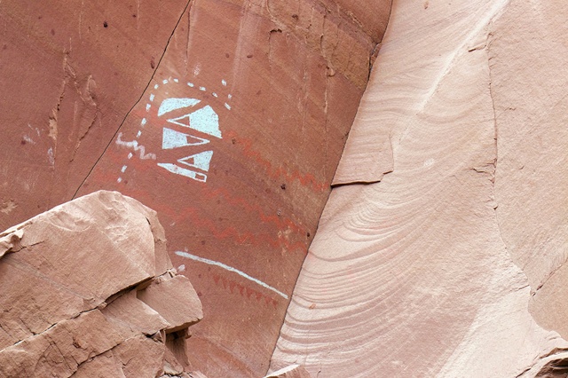
I'm calling these the “Samurai Flag” ruins because of the large distinctive pictograph that appears to hang over the complex. It reminds me of all the banners in the 1985 movie Ran. You can see the similarity to this
PHOTO.
This complex is a really an interesting one and I hope that you enjoy Nick and Shelby's photos. One thing I know, is that if I had been one of the residents way back then, I sure wouldn't have wanted the job of fetching water every day!
Note photo takers are given in the titles under the thumbnails:
Kickass Trekkers on this trip were: Bill Mooseker, Nick McMahan, Tracy McMahan, Jon Younger, Fred Stong, Mike Stong, Will Stong, Nancy Stong, Allan Hoseth
The descriptions under the photo thumbnails in the album sometimes contain links to maps or additional information. These are identified by "Blue” text for links. I've also inserted links to Google Maps to show where certain photos in the album were taken or to locate features shown in the photos. Click on the link, close the sidebar, and choose satellite view. Basically, you can then zoom in and out using the mouse wheel or drag the map by clicking and holding.
The thumbnails do not do justice to the ruins, petroglyphs and pictographs, so I would recommend enlarging them as well. Please take the time to view the many videos to better experience what it was like to be there.
Troop 24 Kickass Trekkers Backpacking Trip
-Cascade Bill Mooseker
Date(s): May 6-10,2019. Album by Cascade Bill. 1 - 47 of 47 Total. 694 Visits.
To enlarge photos, click on the thumbnail - the photo will pop up enlarged to 1024 pixels max (height or width). To view at Original size, just click on the enlarged photo, which will show the photo enlarged to fit the screen. Click on the screen to enlarge that portion of the photo at original resolution. Click again to reduce.
If you want to save photos to your computer, click the box under the thumbnails of all the photos you want to download. Then click the "Download" button at the top of the album. Pick the size you'd like to download (Original is best)and the photos will be downloaded as a zip file to the folder of your choice.
enlarge 394KB, 1024x682 14 2019 ut Samarai Flag Ruin 012 nickEdit
View of the main structure. As an engineer, what puzzles me is that part of the back wall has been constructed against the bedrock (why not just use the bedrock wall) and then curves out leaving a space between it and the bedrock that is closed off by the end wall. See photo 16 for details of this curved wall. (enlarge to view)
enlarge 326KB, 682x1024 15 2019 ut Samarai Flag Ruin 013 nickEdit
Main structure - looks like there might have been an opening here as the protruding blocks look like a support for a sill. Note the double withe construction, which would make a more stable wall.
Photo from 2001 showing back of curved wall with small openings near the top and a large rectangular opening at the bottom. Who knows what these were for? The big opening would give access to the space created between the wall and the bedrock. From our perspective, we would say that it was a fireplace but there is no evidence of carbon deposits from a fire. The small holes could be either ventilation openings or for inserting roof beams but to me the span is too great for that size beam.
enlarge 414KB, 1024x682 17 2019 ut Samarai Flag Ruin 014 nickEdit
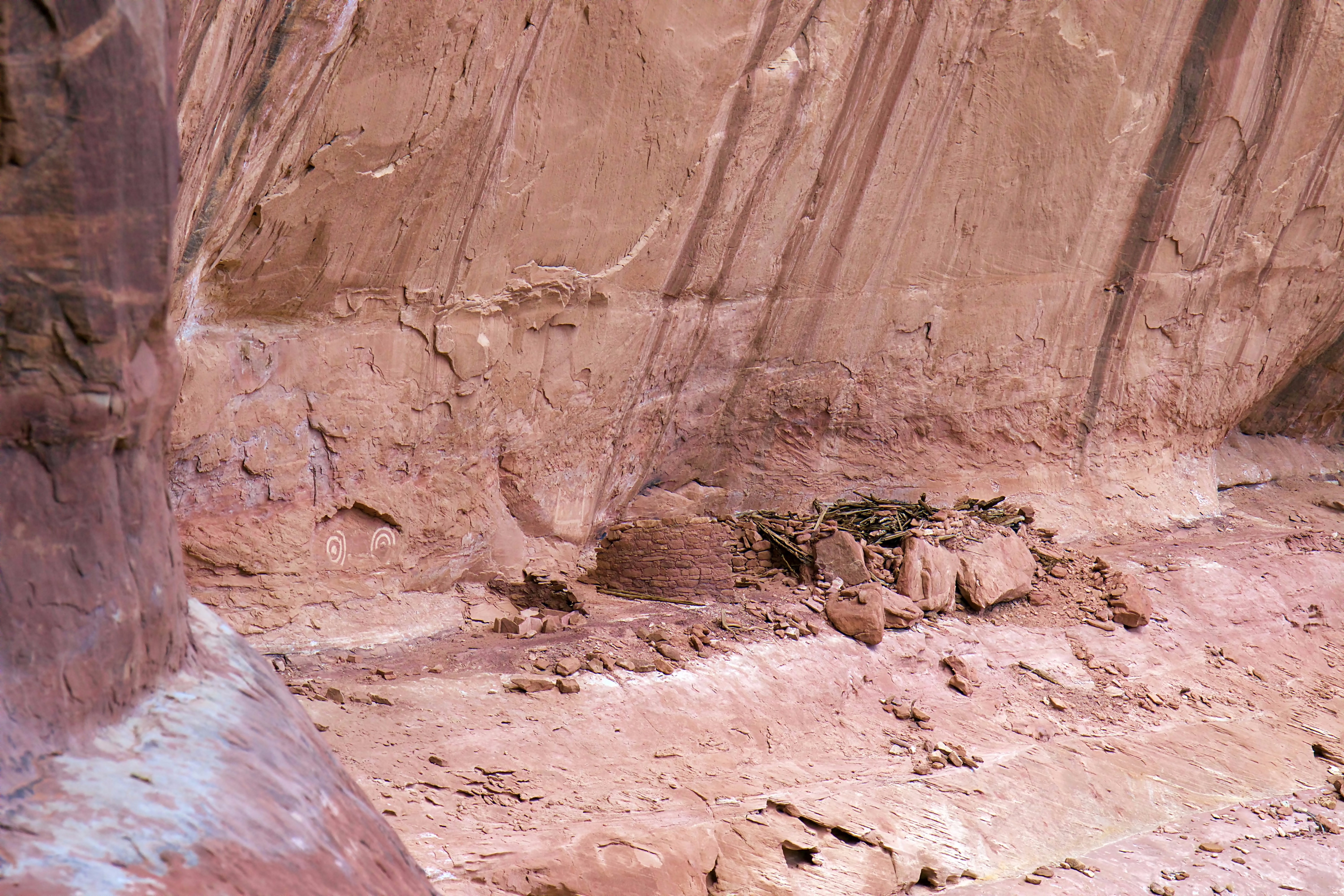
Pile of rubble to the right of the main structure. I think this a kiva (see following photos). On the ledge in back are three structures I'll call ruins A, B, and C. Ruin C appears to be two separate structures abutting each other.
enlarge 366KB, 1024x682 19 2019 ut Samarai Flag Ruin 015 nickEdit
Ruin A also appears to have been extended with an opening at the left side sometime after the initial construction. Note that it would have been difficult to access the opening in this stucture. Building B has only a remnant of wall left - no rubble evident in the foreground. Note that it is a different type of construction as well with a clay slurry plaster having been applied to the surface.
enlarge 314KB, 682x1024 27 2019 ut Samarai Flag Ruin 020 nickEdit Another view (note upright flat rock past the opening)Edit
enlarge 324KB, 1024x682 28 2019 ut Samarai Flag Ruin 022 nickEdit
Edge on view of previous wall with door. It appears that the stone wall has fallen - structural failure due to no perpendicular stone wall corner to brace the wall. The stucco wall did not provide any lateral support. All of the other walls in the ruin complex are stone except this one wall. Why did they take this shortcut?
enlarge 376KB, 682x1024 29 2019 ut Samarai Flag Ruin 023 nickEdit
Interior of stucco wall - exposed branches oriented vertically. At the bottom corner, it looks like they started to plaster the inner side of the wall but gave up.
enlarge 326KB, 1024x682 32 2019 ut Samarai Flag Ruin 025 nickEdit
This is the structure that was noted in the previous photo. It's hard to say what is going on here. The rectangular ruin shown in photo 23 is on the other side of this jumble.
2001 photo shows Rectangular boxes made of flat stones buried in the sand. Similar boxes can be seen at the Owl Eyes ruin (See HERE) and in Slickhorn Canyon 2004 (See PHOTO) Note also the similar rocks jutting up from the floor in photos 27 & 28.
