Thanks for the great photos. I haven't been to Carpp Lake since I was a young boy of 12 (now nearing 49 years old). The creek, lakes, ridge and nearby Carpp mine were all named after my great grandfather Charles A. Carpp and his son Charles H. Carpp who ran the sapphire mine on Carpp Ridge. Hope to take my kids back there someday for a visit. - Charles J. Carpp | http://mysite.verizon.net/reswb9uj/, Thu, 31 May 2007 9:42PM
Bill-
I found your pictures googling '"Sawed Cabin" Pintler'. We're thinking about doing your hike in the reverse (so we would go from Sawed Cabin to Oreamnos). Do you have any tips for finding the correct route from SC to O?
Great pics - we really enjoyed them. Brian - Brian L, Tue, 22 Aug 2006 5:59PM
enlarge 170KB, 800x609 1 mt05-018amap1 Map for Day 1: After our trip to Granite, we continued on to the Carpp Creek Trailhead, arriving in the lengthening shadows of late afternoon. We camped overnight at the trailhead - Andrew and I pitched our tent but Roger and Shelby slept under the stars. In the morning, Shelby and Roger were a couple of corpse-sicles - covered by a thick frosting of ice from the heavy dew. Soon the sun came over the hill and we put out our bags and tent fly to dry and got our gear together. Roger and Shelby drove to the Middle Fork TH and left the car and walked back. After they got back we headed up the Carpp Creek Trail. Our destination was Carpp Lake. (It is recommended that this map be viewed at original size).
enlarge 102KB, 522x800 2 mt05-018b Shelby takes a break at the intersection of the Carpp Cr and Tamarack Lake (abandoned) trail. Note old signpost behind Shelby. If you want to take the Tamarack Lk trail keep your eyes peeled as it is easy to miss as brush has been piled over the old trail. (This is about 2 miles and 500 elev gain from the trailhead.
enlarge 97KB, 522x800 3 mt05-018b1 Roger in his favorite hiking shirt (see trips from 2001 onwards).
enlarge 98KB, 522x800 4 mt05-018b2 Andrew - Ipod engaged and Camelback ready. This was Andrew's first hike since 2002 due to a snowboarding accident and two knee surgeries.
enlarge 145KB, 800x600 5 mt05-019a Carpp Creek Crossing.
enlarge 139KB, 600x800 6 mt05-020a Andrew crossing Carpp Creek. This is about 2 3/4 miles from the trailhead (700' elev gain)
enlarge 131KB, 600x800 7 mt05-021a Andrew at Carpp Creek crossing.
enlarge 136KB, 800x533 8 mt05-022r "Wildlife" along trail. One of the hazards along the trail were fresh cow flops.
enlarge 172KB, 800x533 9 mt05-023r Local "wildlife"
enlarge 152KB, 522x800 10 mt05-024b Andrew at Junction of Carpp Creek trail with the Carpp Lake Trail. (3.6 mile and 950' elev gain from the TH). The trail heads up steeply from this point.
enlarge 79KB, 600x800 11 mt05-025a Carpp Lake and Warren Peak from near our camp. All told it was about 5.5 miles and 1700' elev gain from the Trailhead. We met a couple parties of day hikers (One included a pistol packin' Momma with a unique between the breasts holster) but no one else was camped at the lake - a wonder considering that it was a weekend in mid August.
enlarge 123KB, 800x533 12 mt05-025r Shelby trying his luck.
enlarge 115KB, 800x533 13 mt05-026r That's me way down there trying to catch some cutthroat trout. Fishing was poor to fair - I caught only a couple of small ones.
enlarge 119KB, 600x800 14 mt05-027a Even though the fishing wasn't great, it will still make for one of the most memorable days of the year.
enlarge 92KB, 800x533 15 mt05-028r Roger's "frog's eye" view from the meadow near the outlet of the lake.
enlarge 105KB, 800x533 16 mt05-029r The outlet of Carpp Lake (actually the middle and largest lake of 3 - see map picture). The lower lake was fairly large but very shallow. Note chipmunk on top of rock (zoom photo).
enlarge 112KB, 533x800 17 mt05-030r Warren Peak from the outlet of Carpp Lake.
enlarge 82KB, 533x800 18 mt05-031r Telephoto view of Warren Peak.
enlarge 130KB, 800x533 19 mt05-032r Chipmunk at the outlet.
enlarge 82KB, 800x533 20 mt05-033r Dwarf Alpine Fireweed and Mountain Daisies in the meadow along the shore of Carpp Lake.
enlarge 40KB, 800x533 21 mt05-034r Bumble Bee and Mountain Daisy.
enlarge 176KB, 800x533 22 mt05-035r Butterflies and a myriad of flowers.
enlarge 159KB, 800x533 23 mt05-036r More butterflies and flowers.
enlarge 106KB, 800x533 24 mt05-037r Close up of Butterfly.
enlarge 127KB, 800x533 25 mt05-038r More butterflies.
enlarge 113KB, 800x533 26 mt05-039r Sunlight on the lakeshore grasses.
enlarge 109KB, 533x800 29 mt05-042r Is it Chip or Dale?
enlarge 80KB, 800x533 30 mt05-043r Blue Gentian - likes marshy areas such as the lakeshore of Carpp Lake.
enlarge 84KB, 800x533 31 mt05-044r Another view of the blue Gentians around Carpp Lake.
enlarge 89KB, 800x600 32 mt05-045a The previous campers at our campsite had dumped two large filleted fish remains into the water adjacent to the campsite. Roger went in and "fished" them out.
enlarge 72KB, 800x533 33 mt05-046r These fish carcasses show that there are some fairly big ones in Carpp Lake, but we weren't so lucky. Note the red gill flaps denoting that these are cutthroat trout.
enlarge 62KB, 800x533 34 mt05-047r Another view of Carpp Lake and Warren Peak.
enlarge 76KB, 800x600 35 mt05-048a Carpp Lake is a beautiful lake - the Highline Trail (which we joined at the lower end of the lake) passes over the low pass at center to drop past Upper Carpp Lake and drops back down into the Carpp Creek drainage.
enlarge 45KB, 800x600 36 mt05-049a Telephoto view of Warren Peak.
enlarge 59KB, 800x600 37 mt05-051a Shelby fishing in Carpp Lake.
enlarge 163KB, 800x600 38 mt05-053a Our camp - morning of Day 2: Roger, Shelby, Bill (obscured). There was a campfire ban in effect so we had no campfires during the trip.
enlarge 158KB, 800x600 39 mt05-054a Roger and Bill . It was a cold morning until the sun got over the hill, so we had our fleece on.
enlarge 114KB, 800x600 40 mt05-055a The morning son finally comes over the ridge on a very still Carpp Lake.
enlarge 187KB, 800x600 41 mt05-056a Our Camp - Packing up after breakfast.
enlarge 132KB, 600x800 42 mt05-057a One of the many resident camp chimpmunks - coming out to see what they could find.
enlarge 143KB, 800x600 43 mt05-058a Chimpmunk plays hide and seek.
enlarge 99KB, 800x533 44 mt05-060r Roger packing up his troop gear pile - Why do we still call it troop gear after all the guys have been out of the troop for four years?
enlarge 112KB, 800x533 45 mt05-061r Bill and Andrew packing up. Note Andrew's knee brace.
enlarge 95KB, 600x800 46 mt05-062a Before we take off - Andrew and one final view of Carpp Lake and Warren Mountain.
enlarge 83KB, 600x800 47 mt05-063a Cascade Bill - ready to head out.
enlarge 177KB, 800x600 48 mt05-064a Roger and Shelby - "Good to Go" mode. Waiting for Bill to get up the trail aways before heading out.
enlarge 176KB, 595x800 49 mt05-064rmap2 Map for Day 2: From our camp on the NW shore of Carpp Lake we head west along the Hiline Trail climbing a couple of hundred feet over a ridge and then dropping down to Tamarack Creek. A few switchbacks past the creek crossing you can see the faint tread of the old Tamarack Lake Trail (1.8 mi from Carpp Lake) coming up the hill. Turning south, the trail climbs through open forest to a junction where the Hiline Trail turns west and the Tamarack Lake trail continues South. (2.4 mi from Carpp Lake). After a short distance, a small lake is seen through the trees (Little Annie Lake). Past the lake the trail starts climbing seriously, finally breaking out in meadows and trending downhill (you think you'ree finally there), but the trail (not as shown on the topo map), heads up again, rounding a small pond (not shown on the map) before arriving at beautiful Tamarack Lake (3.6 mi and 1100' elev gain from Carpp Lake). Note map best viewed at original size.
enlarge 159KB, 600x800 50 mt05-065a Just before breaking out into the meadows below Tamarack Lake, the ruins of this old cabin are seen to the right of the trail.
enlarge 130KB, 600x800 51 mt05-066a Tamarack Lake? No! - just a small pond (not shown on the map). The trail goes arond the lake on the left side.
enlarge 114KB, 800x533 52 mt05-067r Another view of the small pond - Previous photo was taken from the trees at the left of the photo (you can see the trail going around the lake shore).
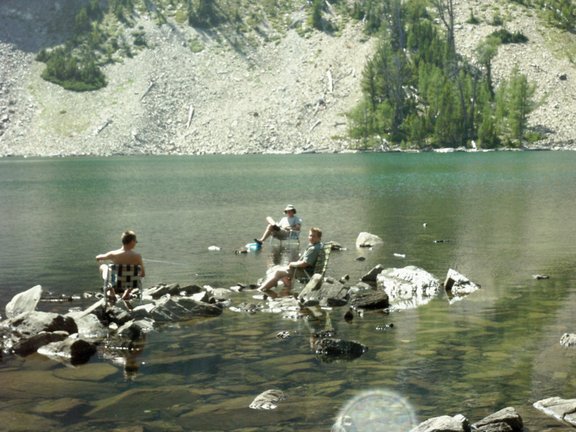
enlarge 114KB, 600x800 53 mt05-068a After a short hiking day - Time to Relax. Nothing finer than sitting in your lawn chair out in the lake. Shelby got a 16 inch cutthroat trout on his second cast - no further action at all. We (well I did) filleted the fish and cooked it, but the flesh was very soft and we ended up burying most of it. I would rather eat a passle of 8-10 inchers any day, although the large rainbows we caught in Idaho were really good.
enlarge 111KB, 800x600 54 mt05-070a Close up of the guys in their lawn chairs.
enlarge 103KB, 600x800 55 mt05-071a After the fishing flunked out, I found this shady spot to read my book - what a view.
enlarge 75KB, 800x533 56 mt05-072r Roger opted to climb up the slope above the lake and got this view - Our camp was in the trees between the main lake and the small pond.
enlarge 88KB, 800x533 57 mt05-073r View from the talus slope above the lake. We were hoping (in vain) for goats to appear.
enlarge 124KB, 800x533 58 mt05-074r Another view.
enlarge 122KB, 800x533 59 mt05-075r Telephoto view of our camp - you can see the rocks that the lawn chair pictures were.
enlarge 125KB, 533x800 60 mt05-076r Looking down the talus to the lake.
enlarge 92KB, 800x600 61 mt05-077a Alpenglow over Tamarack Lake.
enlarge 92KB, 600x800 62 mt05-078a Alpenglow reflection of Warren Peak in Tamarack Lake.
enlarge 77KB, 600x800 63 mt05-079a Tamarack Lake.
enlarge 77KB, 533x800 64 mt05-080r Tamarack Lake.
enlarge 91KB, 533x800 65 mt05-081r Tamarack Lake.
enlarge 91KB, 533x800 66 mt05-082r Tamarack Lake.
enlarge 93KB, 533x800 67 mt05-083r Tamarack Lake.
enlarge 88KB, 533x800 68 mt05-084r Tamarack Lake.
enlarge 94KB, 800x533 69 mt05-085r Tamarack Lake.
enlarge 103KB, 800x533 70 mt05-086r Shelby - near our camp on Tamarack Lake.
enlarge 100KB, 533x800 71 mt05-087r View across Tamarack Lake Outlet.
enlarge 106KB, 800x533 72 mt05-088r Tamarack Lake Outlet.
enlarge 76KB, 533x800 73 mt05-090r Scenic view looking up lake from Tamarack Lake outlet.
enlarge 85KB, 533x800 74 mt05-091r Tamarack Lake.
enlarge 79KB, 533x800 75 mt05-092r Tamarack Lake.
enlarge 72KB, 800x533 76 mt05-093r Warren Peak
enlarge 122KB, 800x533 77 mt05-094r Camp deer.
enlarge 80KB, 800x533 78 mt05-095r Camp deer.
enlarge 93KB, 800x600 79 mt05-096a Roger making "Pink Flamingo" video.
enlarge 91KB, 800x600 80 mt05-097a Roll Tape (Roger) - actually it's digital. "Actually, that one is a tape. Its the black one thats..." View Comments...
enlarge 176KB, 591x800 81 mt05-097a-map3 Map for Day 3: Tamarack Lake to Johnson Lake. From Tamarack Lake we retrace our route from Day 2 down to the Hiline Trail where we head west over a small hill and then down to cross the creek coming down from Glover Basin (Tamarack Lake). After crossing the creek, the trail climbs steeply up to cross Porter Ridge (2 mi and 400' elev gain) from Tamarack Lk. After crossing the ridgeline, the trail trends up for a while before trending down for a long traverse through trees, meadows and a talus slope. Reaching another ridge, the trail heads down into the Falls Fork of Rock Creek drainage passing the trail to Edith Lake (not as shown on topo but much higher up) before seriously switchbacking down to meet the Falls Fork Trail to Johnson Lake (4.4 mi from Tamarack Lake). Note map best viewed at "Original Size".
enlarge 124KB, 600x800 82 mt05-098a Bill along Hiline trail (just before crossing creek coming down from Glover Basin).
enlarge 147KB, 600x800 83 mt05-099a View down trail up Porter Ridge.
enlarge 127KB, 800x600 84 mt05-100a View from trail up Porter Ridge gives our last view of Warren Peak.
enlarge 79KB, 800x600 85 mt05-101a View from Porter Ridge west to Rock Creek drainage.
enlarge 167KB, 600x800 86 mt05-102a Bill coming down trail traversing Porter Ridge.
enlarge 117KB, 800x600 87 mt05-103a Huge talus field on Porter Ridge.
enlarge 114KB, 800x600 88 mt05-104a Andrew at talus field.
enlarge 86KB, 800x533 89 mt05-105r Looking across talus field to Rock creek drainage.
enlarge 53KB, 800x533 90 mt05-106r Beginning the descent into the Rock Creek basin. Johnson Lake lies behind the trees of the low ridge left of center. Pintler Pass is the low spot on the far ridge at the left of the picture. The highest peak on the ridge is East Pintler Peak. If you look closely you can see many areas where a forest fire has burned thru the valley.
enlarge 132KB, 800x533 91 mt05-107r Shelby going down the switchbacks near the Edith Lake trail cutoff.
enlarge 120KB, 800x533 92 mt05-108r Shelby - we met our only other backpacking party of the trip, who were heading to Edith Lake as we rested where the trail to Edith left the Hiline Trail.
enlarge 162KB, 800x533 93 mt05-109r After the descent to the junction of the Falls Fork trail, the Hiline Trail passes through a burn area - Not Much Fun hiking - hot and dusty. Heading up the trail to Johnson Lake, the trail enters a burn area that on a hot day would be pure hell. Fortunately, at the upper end of the valley, the trail leaves the burn area to enter the cool forest for the final switchbacks up over the ridge to Johnson Lake. Before reaching the lake, the Burn area is entered again and a trail sign and map outlining camping restrictions directs you to camps on either side of the lake. As the burn area is on the east shore we take the main trail along the west shore, camping at a nice camp at the south end of the lake.
enlarge 89KB, 800x600 94 mt05-111a Andrew at Johnson Lake - There are camping restrictions (designated campsites only) , but as we wee the only backpackers at the lake we found a primo side at the upper end of the lake. You can see that the burn area extended around the north east (upper left) of the lake.
enlarge 114KB, 600x800 95 mt05-112a View from our camp down towards the meadow at the upper end of the lake.
enlarge 172KB, 600x800 96 mt05-113a View of the alpine forest and meadows near our camp at Johnson Lake.
enlarge 108KB, 600x800 97 mt05-114a Andrew in meadow above Johnson Lake - Peak 9805 in background.
enlarge 106KB, 800x533 98 mt05-115r Another Camp deer at Johnson Lake - this one was in poor shape.
enlarge 115KB, 800x533 99 mt05-116r Camp deer.
enlarge 117KB, 800x533 100 mt05-117r Camp deer.
enlarge 73KB, 800x600 101 mt05-118a Shelby and Roger - East Pintler Peak is at right.
enlarge 67KB, 800x600 102 mt05-119a Sunset over Johnson Lake catches the silver forest of the old burn - the Continental Divide Trail goes through the basin between the peaks to a pass above Rainbow Lake. (See map).
enlarge 81KB, 600x800 103 mt05-120a Meadow and stream above Johnson Lake. We were hoping to see Moose as twilight fell but the only moose were Moose(kers, Andrew and Bill).
enlarge 63KB, 600x800 104 mt05-121a East Pintler Peak (9486')
enlarge 71KB, 800x533 105 mt05-122r Johnson Lake - I tried casting a lure but no strikes or follows. Didn't see any fish feeding on the surface either. You can see that the forest fire extends over a significant part of the northeast side of the lake.
enlarge 69KB, 800x533 106 mt05-123r Silver forest above Johnson Lake.
enlarge 73KB, 800x533 107 mt05-124r Peak 9805'
enlarge 85KB, 800x533 108 mt05-125r Another view of the stream flowing into Johnson Lake.
enlarge 68KB, 800x533 109 mt05-126r Meadow and Lake.
enlarge 64KB, 533x800 110 mt05-127r Meadow and Lake.
enlarge 86KB, 800x533 111 mt05-128r East Pintler Peak and meadows above Johnson Lake.
enlarge 86KB, 533x800 112 mt05-129r Inlet stream and meadow above Johnson Lake.
enlarge 41KB, 800x533 113 mt05-134r As night fell we noticed a brown haze over the valley to the north - Forest Fire??