Back to Bridger 2
Bridger Wilderness - Wyoming
August 2001
by Cascade Bill Mooseker
Day 1: Big Sandy Trailhead to Vee Lake
Day 2: Vee Lake to Lonesome Lake
Cirque of the Towers
Chickens to Jackass Pass!
Day 3: Lonesome Lake to Valentine Lake
Day 4: Valentine Lake to Grave Lake
Day 5: Grave Lake over Hailey Pass to Skull Lake
Day 6: Skull Lake to Camp near Big Sandy
Trailhead thru Forest Fire enroute.
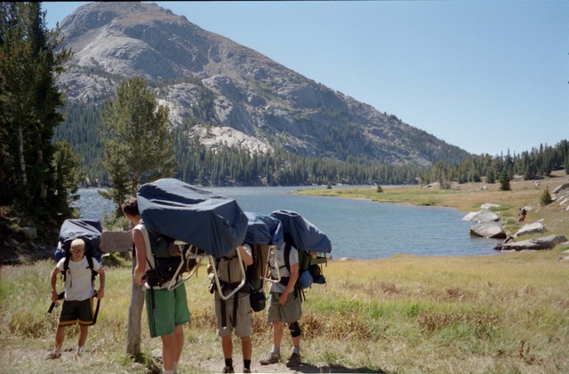
Backpacks in "Chicken" mode at Big Sandy Lake
This was our second trip to Wyoming's Bridger Wilderness. Our first was in 1998. The scenery was awesome, but the fishing was only so-so, not like our previous trip. The guys usually like to surprise me with something unsuspected or outlandish and on this trip they pulled off a whopper. When we got to the trailhead, they pulled out four chickens that they had specifically raised over the summer for this purpose to my complete and utter consternation.
All in all, it was a great trip with covering 6 nights and 7 days (with the first and last being very short). In total, we hiked about 42 miles with 9600 ft of elevation gain mostly over 10000 ft. We set a record for Troop 24 at 12539 ft climbing a small knoll on the Lizard Peak trail surpassing the previous record of 12420 at Italy Pass in the Sierra Nevada, California in 1999.
In August 2001, only Shelby, Roger, and Austin were still in the scouts, so this trip was done as a "Kickass Trekker" trip.
Note photo titles ending in "j" are by Jason Smith; "r" by Roger Shively; all other photos & videos are by Cascade Bill
Kickass Trekkers on this trip were: Bill Mooseker,Fred Stong, Brian "Buckwheat" Sisk, Jason Smith, Danny Stallings, Peter Goodwin, Roger Shively, Shelby Stong, Austin Peckinpaugh
The descriptions under the photo thumbnails in the album sometimes contain links to maps or additional information. These are identified by "Blue” text for links. Maps are best viewed at original size.
I've revised this album recently. When I first uploaded this album back in late 2001, high speed internet was unheard of, so photo resolutions were pretty low in order to allow uploading at dial-up speeds. I've rescanned my photo negatives of this trip at the highest resolution available to me and replaced the old low resolution ones. I don't have access to the photos taken by Jason and Roger, so they remain at the low resolution. I've also digitized the Hi-8 videos that I took on the trip and have added them to the album.
Troop 24 Kickass Trekkers Backpacking Trip
-Cascade Bill Mooseker
Date(s): August 25-31, 2001. Album by Cascade Bill. 1 - 165 of 165 Total. 13036 Visits.
enlarge 335KB, 995x1024 1 picsnvids
To get the plugin just Google "videolan" or CLICK HERE FOR DOWNLOAD for Windows. There is a MAC version as well. Disable the Quicktime plugin if you use Videolan. To view fullscreen videos click the icon on the top right of the video when it starts playing.
If you want to save photos to your computer, click the box under the thumbnails of the photos you want to download. Then click the "Download" button at the top of the album. Pick the size you'd like to download (Original is best)and the photos will be downloaded to a folder of your choice.
enlarge 26KB, 791x1024 2 Back to Bridger 2001.pdf
PDF file showing mileages and elevations for our trip with daily summary for the miles hiked and elevation climbed and lost. Click on thumbnail and click on "Open this PDF" to view.
enlarge 107.50MB, 1024x682 3 2001 wy day1 vid 0 chickens.mp4 VIDEO - Click Photo to View.
After a long drive from Burley, Idaho and a lunch in Pinedale and another long drive on a washboarded dirt road we arrived at the Big Sandy trailhead in the late afternoon. As we were getting our gear organized, Roger brought out four chickens that they had hidden in Fred's Suburban for the nearly 1000 mile trip. My reaction is caught here.
enlarge 188KB, 1024x708 4 brg001j
Big Sandy Trailhead: Getting ready to head out - chickens and all - Fred, Buckwheat, Peter, and Roger. Note: Lawn chair doubles as chicken carrier.
enlarge 109KB, 723x1024 5 brg002j Austin in chicken carrying mode - Big Sandy Trailhead
enlarge 256KB, 1024x824 6 2001-366-028
Jason, Buckwheat, Shelby, Fred, Austin, and Roger - Finally on the trail.
enlarge 72KB, 1024x723 7 brg005j
Jason in the shadows at our camp at Vee Lake- Big Sandy Mountain at center & Sheistler Mtn at Right.
enlarge 181KB, 1024x673 8 2001-366-029
Because of our long drive, we got a very late start and rather than go hell bent for leather up the Big Sandy Trail, we took the longer route past Meeks Lake and then on to Vee Lake for a short 2.1 miles day.
enlarge 54.17MB, 1024x682 9 2001 wy day1 vid 1 vee lake.mp4 VIDEO - Click Photo to View. Fred and Jason enjoy the sunset at Vee Lake
enlarge 143KB, 677x1024 10 brg006r
Roger putting the chickens to bed (They wanted to roost on Peter but he didn't think that was a good idea).
enlarge 103KB, 685x1024 11 brg006r2 Roger, who will never make it as a geek!
enlarge 124KB, 1152x393 12 wyd201a
Day 1: Big Sandy Trailhead to Vee Lake Day 2: Vee Lake to Big Sandy Lake (via Diamond Lake Trail) (This Map best Viewed at Original size)
enlarge 192KB, 1024x671 13 2001-366-030
Trail between Vee Lake and Diamond Lake. Big Sandy Mtn at right center.
enlarge 57.08MB, 1024x682 14 2001 wy day2 vid 1.mp4 VIDEO - Click Photo to View. Heading out from Vee Lake in the morning.
enlarge 324KB, 731x1024 15 2001-366-031 Fred at Big Sandy Lake.
enlarge 124KB, 727x1024 16 brg009j Shelby & friend - break at Big Sandy Lake
enlarge 111KB, 723x1024 17 brg010j Jason, Brian, and Peter - Big Sandy Lake
enlarge 336KB, 793x1024 18 wyd201b
Day 2: Big Sandy Lake to Lonesome Lake vi a Jackass Pass. (This Map best viewed at "Original" size.)
enlarge 111KB, 1024x723 19 brg011j Danny & Austin - Big Sandy Mtn above Big Sandy Lake
enlarge 57.45MB, 1024x682 20 2001 wy day2 vid 2.mp4 VIDEO - Click Photo to View. Hiking past Big Sandy Lake and then up the Jackass Pass Trail.
enlarge 262KB, 1024x674 21 2001-366-032
Junction of the Big Sandy and Jackass Pass trails at the upper end of Big Sandy Lake.
enlarge 284KB, 1024x743 22 2001-366-033
View from trail above Big Sandy Lake - looking south.
enlarge 270KB, 1024x673 23 2001-366-034 View along trail above Big Sandy Lake.
enlarge 144KB, 768x1024 24 brg015j Bill making his way along trail.
enlarge 130KB, 1024x763 25 brg016j During a break- Shelby practices his rock climbing techniques.
enlarge 139KB, 755x1024 26 brg017j Jason trying his.
enlarge 99KB, 1024x758 27 brg018j
Austin and Fred pick their way along a rough section of the trail up to Jackass Pass.
enlarge 148KB, 708x1024 28 brg019j Peter poses at the "Tooth" near Jackass Pass.
enlarge 113.89MB, 1024x682 29 2001 wy day2 vid 3 Jackass Pass.mp4 VIDEO - Click Photo to View.
On the last stretch up to Jackass Pass. Views from the pass of Lonesome Lake and the impressive Cirque of the Towers.
enlarge 326KB, 780x1024 30 2001-366-035
The trail climbs high to a false summit and then drops a couple of hundred feet before the final climb to Jackass Pass. The peaks of the Cirque of the Towers are seen beyond.
enlarge 164KB, 760x1024 31 brg021j Fred checking out an interesting rock near Jackass Pass.
enlarge 55.03MB, 1024x682 32 2001 wy day2 vid 4 Jackass Pass 2.mp4 VIDEO - Click Photo to View. Taking a break at Jackass Pass
enlarge 126KB, 1024x723 33 brg022j
The guys at Jackass Pass: (Front) Austin, Shelby, and Danny. (rear) Roger, Jason, Brian, and Peter.
enlarge 149KB, 1024x766 34 brg023j Back: Roger, Jason, Brian, and Peter. Front: Austin, Shelby, & Danny
enlarge 134KB, 1024x758 35 brg024j Peaks of the Cirque of the Towers- Pylon (left) & Watch Tower (right)
enlarge 122KB, 1024x727 36 brg025j
From Left to Right: Sharks Nose, Overhanging Tower, Wolf's Head, & Pingora Peak - a favorite of the climbers who come to the Cirque of the Towers.
enlarge 109KB, 1024x720 37 brg026j Pingora Peak on the left and Texas Pass on the right.
Lonesome Lake - We had hoped to go over Texas Pass (the obvious low point on the ridge) but we decided to use the Lizard Head trail instead.
enlarge 262KB, 1024x672 40 2001-367-003
Upper meadows above Lonesome Lake - Peaks: Pylon and Watch Tower.
enlarge 29.79MB, 1024x682 41 2001 wy day2 vid 5 Jackass Pass 3.mp4 VIDEO - Click Photo to View. Heading down from Jackass Pass to Lonesome Lake.
enlarge 324KB, 1024x729 42 2001-367-004 Fred on his way down to Lonesome Lake.
enlarge 343KB, 1024x677 43 2001-367-005 Bill at Jackass Pass.
enlarge 146KB, 1024x768 44 brg032b Close up of Bill
enlarge 328KB, 693x1024 45 2001-367-006 Jason at Jackass Pass.
enlarge 149KB, 1024x769 46 brg034b Close up of Jason.
enlarge 105KB, 1024x763 47 brg035j
Camp near Lonesome Lake.- Most of the guys are still in their bags. Day 2 was a pretty hard day: 7 miles and over 2000 ft climbed. Day 3 would be even harder!
enlarge 163KB, 1024x770 48 brg036j Peter - breaking camp near Lonesome Lake.
enlarge 161KB, 1024x739 49 brg037j Filtered sunlight hits the camp as breakfast is being prepared.
enlarge 310KB, 653x1024 50 wyd301a
Day 3: Camp 2 (near Lonesome Lake) to Valentine Lake via the Lizard Head & Bears Ears Trail. (This Map best viewed at "Original" size.)
enlarge 356KB, 1024x750 51 2001-367-007 View of the Cirque of the Towers from our camp near Lonesome Lake.
enlarge 65.42MB, 1024x682 52 2001 wy day3 vid 1 camp.mp4 VIDEO - Click Photo to View.
View of the Cirque of the Towers from our camp and getting ready to move out.
enlarge 287KB, 1024x670 53 2001-367-008
Cirque of the Towers down the valley from Lonesome Lake - Pingora Peak dominates the group of peaks.
enlarge 166KB, 718x1024 54 brg040j
The Popo Agie canyon below the C.O.T. is very impressive, almost Yosemite-like.
enlarge 310KB, 732x1024 55 2001-367-009
Popo Agie Canyon Walls (Dog Tooth Peak) near the junction with the Lizard Head Trail.
enlarge 269KB, 1024x685 56 2001-367-010
Looking back at the Cirque of the Towers from near the junction of the Lizard Head Trail.
enlarge 151KB, 1024x770 57 brg044j
From the Junction here, the Lizard Head Trail heads into the trees and up the side of the canyon.
enlarge 154KB, 711x1024 58 brg045j Taking a break at the Lizard Head Trail jctn.
enlarge 155KB, 1024x767 59 brg046j Close up of Jason and Shelby
enlarge 133KB, 1024x756 60 brg047j Danny and Austin- lawn chair bliss.
enlarge 314KB, 1024x671 61 2001-367-012
View of the Cirque of the Towers from the Lizard Head Trail (Near the Bear Lakes)
enlarge 103KB, 1024x769 62 brg049j Fred & Shelby - C.O.T. and Lonesome Lake are way back there now.
enlarge 313KB, 679x1024 63 2001-367-013 View of the Cirque of the Towers and Lonesome Lake.
enlarge 155.28MB, 1024x682 64 2001 wy day3 vid 2 Lizard Head.mp4 VIDEO - Click Photo to View.
Taking a break above the magnificent Popo Agie Valley as we climb the steep Lizard Head trail.
enlarge 328KB, 679x1024 65 2001-367-014
Lizard Head Peak and the Bear Lakes from the Lizard Head Trail.
enlarge 100KB, 1024x711 66 brg053j Jason - the Bear Lakes form the backdrop.
enlarge 308KB, 678x1024 67 2001-367-015
Unnamed lakes above the Bear Lakes. Glaciers are on the back side of Lizard Head.
enlarge 269KB, 1024x747 68 2001-367-016
Fred makes his way across the barren landscape near the highest point of the Lizard Head Trail.
enlarge 126KB, 1024x770 69 brg056j
Roger and the rugged country along the summit of the Lizard Head Trail.
enlarge 127KB, 1024x766 70 brg057j Close up of Roger (World's Greatest Dad!)
enlarge 87KB, 1024x756 71 brg058j Lunch Break at the summit (11875') of the Lizard Head Trail.
enlarge 57KB, 1024x732 72 brg059j "Hammerin" Pete with a honey soaked bagel.
enlarge 75KB, 1024x770 73 brg060j
Jason and Brian at summit of 12539' peak near where we took our lunch break. (This set a record for altitude for Troop 24).
enlarge 82KB, 1024x756 74 brg061j Shelby at summit of 12539' peak.
enlarge 84KB, 1024x727 75 brg062j Jason - Lizard Head from 12539' summit.
enlarge 95KB, 1024x770 76 brg063j If you look at this from the side, it looks like Jason is in a very tight spot.
enlarge 252KB, 1024x716 77 2001-367-017
One of the few glaciers we saw - this was a short way past the high point of the Lizard Head Trail.
enlarge 30.56MB, 1024x682 78 2001 wy day3 vid 3 Lizard Head.mp4 VIDEO - Click Photo to View.
Taking a break near Cathedral Peak in the desolate terrain along the higher elevations of the Lizard Head trail.
enlarge 269KB, 697x1024 79 2001-367-022
We took a break at a pass near Cathedral Peak and the guys climbed this strange outcrop.
enlarge 78KB, 1024x769 80 brg066b Closeup of guys on rock.
enlarge 243KB, 1024x681 81 2001-367-023
Austin - taking in the view of the Eastern side of the Wind Rivers. The mountains to the est were not nearly as spectacular or as rugged as those near the Continental Divide.
enlarge 248KB, 712x1024 82 2001-367-024
The Lizard Head trail ends at the junction with Bears Ears trail in the valley below.
enlarge 345KB, 1024x738 83 2001-367-025
A few switchbacks had to be negotiated - we can see the Bear's Ear trail crossing the valley floor beyond. Our route follows the Bears Ears trail to the left after the junction at the end of the trail that is visible here.
enlarge 280KB, 802x1024 84 2001-367-018
Fred - Heading northwest along the Bears Ears trail - its a long way down to timberline and our camp at Valentine Lake. We were getting tired after one of the longest days ever: 11.4 miles and over 3200 ft climbed all above 10000' in elevation.
enlarge 164KB, 1024x757 85 brg071b Close up of Fred.
enlarge 289KB, 1024x721 86 2001-367-019 Valentine Lake - a beautiful but heavilly used area.
enlarge 82.69MB, 1024x682 87 2001 wy day4 vid 1 valentine Lk.mp4 VIDEO - Click Photo to View.
View of Valentine Lake - Boulder hopping across the Little Wind River
enlarge 237KB, 1024x703 88 wyd401a Day 4: Valentine Lake to Grave Lake Camp. (This Map best viewed at "Original" size.)
enlarge 340KB, 724x1024 89 2001-367-020
Another shot of Valentine Lake with Payson Peak beyond - the fishing was poor.
enlarge 295KB, 1024x670 90 2001-367-021
After a mile or so from Valentine Lake, the trail enters the beautiful meadows of Ranger Park
enlarge 113KB, 1024x758 91 brg075b Close up of Bill
enlarge 235KB, 1024x727 92 2001-368-001
A passing hiker volunteered to take this group picture - Roger, Bill, Austin, Fred, Shelby, Jason, Peter, Danny, and Brian.
enlarge 104KB, 1024x769 93 brg077j Close up - Payson Peak in background.
enlarge 106KB, 1024x756 94 brg078j Jason, Brian, Peter, and Danny
enlarge 219KB, 1024x679 95 2001-368-002
The meadows of Little Wind River (we crossed here) and Payson Peak.
enlarge 332KB, 876x1024 96 2001-368-003
Another view of Payson Peak as we hiked north down the Little Wind River Valley.
enlarge 129.46MB, 1024x682 97 2001 wy day4 vid 2 Grave Lk.mp4 VIDEO - Click Photo to View.
Taking advantage of the beach near the outlet of Grave Lake. Hiking around the lake on our way to Camp 4.
enlarge 126KB, 1024x770 98 brg081j
Taking a break at the upper end of Grave Lake - Shelby and Austin enjoy this sandy beach
enlarge 280KB, 1024x717 99 2001-368-004
View up Grave Lake - Musembeah Peak in the far distance is on the continental divide. The trail skirts Pilot Knob - the rounded peak to the left.
enlarge 114KB, 1024x770 100 brg083j Danny takes a swim in Grave Lake. "Our rule on our trip was, if you went in you went und..." View Comments...
enlarge 244KB, 812x1024 101 2001-368-005
View up Grave Lake - Pilot Knob ahead - The lake does a dog leg to the left of Pilot Knob and extends about as far as we can see here. It is a huge lake..
enlarge 275KB, 717x1024 102 2001-368-006
Fred follows the trail as it winds around Grave Lake. This is near the junction with the "Onyon Medius" (Onion Meadows) trail.
enlarge 256KB, 1024x701 103 2001-368-007
Because of a huge talus slope at the base of Pilot Knob, the trail climbs a few hundred feet to give this view. Fred makes his way at the right.
enlarge 190KB, 1024x673 104 2001-368-008
View back to the end of Grave Lake from the high point below Pilot Knob. You can see that it is really a huge lake.
enlarge 274KB, 777x1024 105 2001-368-009
The upper end of Grave Lake. Our camp near the sandy peninsula jutting into the lake on the right below.
enlarge 136KB, 1024x762 106 brg089j The water was shallow and warm at our camp on Grave Lake.
enlarge 142KB, 708x1024 107 brg090j Jason at our camp at Grave Lake - Pilot Knob in the background.
enlarge 130KB, 1024x769 108 brg091j Creek flowing into Grave Lake near our camp.
enlarge 182KB, 1024x710 109 brg092j Taking it easy in our camp.
enlarge 140KB, 1024x716 110 brg093j Jason and Peter doing a little reading.
enlarge 150KB, 762x1024 111 brg094j
Afternoon sun on Grave Lake. After the ball buster of a day the previous day, today was fairly moderate with 6 miles and about 1850 ft of climbing.
enlarge 330KB, 757x1024 112 wyd501a Day 5: Grave Lake to Skull Lake vi Hailey Pass. (This Map best viewed at "Original" size.)
enlarge 162KB, 1024x708 113 brg095j Packing up at Grave Lake.
enlarge 57.18MB, 1024x682 114 2001 wy day5 vid 1 Grave Lk camp.mp4 VIDEO - Click Photo to View. Breaking camp at Grave Lake
enlarge 316KB, 748x1024 115 2001-368-010
The sheer face of Hooker Mountain - This was near the crossing of Baptiste Creek.
enlarge 106.16MB, 1024x682 116 2001 wy day5 vid 2 Hailey Pass pt 1.mp4 VIDEO - Click Photo to View. On our way up to Hailey Pass
enlarge 321KB, 727x1024 117 2001-368-011 Heading up the trail near Baptiste Creek - Danny hangs back.
enlarge 148KB, 1024x771 118 brg098b Close up.
enlarge 117KB, 1024x763 119 brg099j Peter & Jason.
enlarge 137KB, 710x1024 120 brg100j Peter & Jason - just below the final ascent up Hailey Pass.
enlarge 111KB, 1024x758 121 brg101j Roger and Austin coming up the trail to Hailey Pass.
enlarge 160KB, 1024x733 122 brg102j
Jason and Shelby - Hailey Pass behind them. The final climb was very steep with a lot of switchbacks.
enlarge 135KB, 763x1024 123 brg103j Close up of Jason.
enlarge 116.98MB, 1024x682 124 2001 wy day5 vid 3 Hailey Pass pt 2.mp4 VIDEO - Click Photo to View. Final climb up to Hailey Pass, which lies on the Continental Divide.
enlarge 145KB, 763x1024 125 brg104j Close up of Shelby.
enlarge 106KB, 1024x765 126 brg105j The crew at the top of Hailey Pass.
enlarge 104KB, 1024x736 127 brg106j
Bill, Fred, Shelby, Danny, Jason, Buckwheat, Peter, Austin, and Roger. At the pass we met a couple of women hikers, who were chemical engineers, who engaged Fred in a lively conversation on the way down.
enlarge 366KB, 695x1024 128 2001-368-012 Looking down at our route from the top of Hailey Pass.
enlarge 102KB, 758x1024 129 brg108j Buckwheat at Hailey Pass.
enlarge 296KB, 1024x683 131 2001-368-014 Descending the trail below Hailey Pass - Mt Geikie across valley.
enlarge 313KB, 1024x720 132 2001-368-015 Danny & Peter thread their way between the boulders.
enlarge 125KB, 1024x767 133 brg112j Waiting for Bill at the junction of the Hailey Pass (Bear's Ears) trail and the Pyramid Lake Trail - Shelby, Fred, Austin, (green haired Roger)
enlarge 351KB, 726x1024 134 2001-368-016
Maes Lake - Hailey Pass is at the upper right beyond the shoulder of Pyramid Peak.
enlarge 243KB, 1024x673 135 2001-368-017
Taking a break at Maes Lake - we were going to camp here but the fishing was poor (no strikes or fish) so we went on to Skull Lake.
enlarge 110KB, 1024x754 136 brg115b Austin at Maes Lake.
enlarge 84KB, 765x1024 137 brg116b Brian and Roger - Maes Lake.
enlarge 62.45MB, 1024x682 138 2001 wy day5 vid 4 Break at Maes Lk.mp4 VIDEO - Click Photo to View. Taking a break at Maes Lake
enlarge 214KB, 1024x705 139 2001-368-018 Maes Lake - Tower Peak and the western side of Mt. Hooker(right)
enlarge 96KB, 1024x741 140 brg118j
Our camp at Skull Lake -(Left to Right) Tower, Hooker, & Pyramid Peaks.
enlarge 90.25MB, 1024x682 141 2001 wy day5 vid 5 Skull Lk camp.mp4 VIDEO - Click Photo to View.
Relaxing at our camp at Skull Lake - An enjoyable card game (Danny, Austin, Peter, Roger,and Shelby; Fred takes a nap, and Brian is fly fishing for small trout
enlarge 223KB, 1024x670 142 2001-368-019
Peter - in Camp at Skull Lake. It was a fairly easy day - 5.5 miles and about 1500' climbed.
enlarge 79KB, 1024x759 143 brg120j Sunset at Skull Lake.
enlarge 275KB, 1152x706 144 wyd601a Day 6: Skull Lake to Dad's Lake. Note: North is to the left. (This Map best viewed at "Original" size.)
enlarge 229KB, 1024x643 145 wyd601b Day 6: Dad's Lake to Camp 6 (near Trailhead)
Note: North is to the left. (This Map best viewed at "Original" size.)
enlarge 201KB, 1024x767 146 brg121j Cooking breakfast at Skull Lake - Peter & Danny.
enlarge 273KB, 1024x670 147 2001-368-020 Group Picture before we head out from Skull Lake.
enlarge 306KB, 1024x673 148 2001-368-021 Group pic #2.
enlarge 159KB, 1024x765 150 brg125j Danny and Peter crossing Washakie Creek.
enlarge 261KB, 1024x705 151 2001-368-022
View back towards Washakie Cr meadows- Pyramid peak at the right & Mt. Geikie to the left.
enlarge 181KB, 769x1024 152 brg126j
Bill and Fred near Marm's Lake - We stopped and had our best fishing of the trip.
enlarge 133KB, 1024x767 153 brg127j Peter and Danny - at Mirror Lake.
enlarge 112KB, 1024x775 154 brg128j
Looking over Fish Creek Park from Mirror Lake we could see there was a forest fire ahead (copter is dot above trees)
enlarge 111.23MB, 1024x682 155 2001 wy day6 vid 1 forest fire 1.mp4 VIDEO - Click Photo to View.
As we rounded Mirror Lake, we could see smoke ahead with helicopters ferrying water to a forest fire right where we were headed.
enlarge 186KB, 1024x769 156 brg129j
The fire was on both sides of the trail - Shelby kicking dirt on a hot spot.
enlarge 122KB, 1024x676 157 brg130r Roger and Fred, check out the fire.
enlarge 85KB, 1024x681 158 brg130r2
Looking west, to the treeline at the edge of the meadow at the smoke of the fire.
enlarge 57KB, 1024x769 159 brg131j
Copter with bucket heads to fire. We had intended to camp at the little lake (Divide Lake) that the copter was getting water from.
enlarge 249KB, 1024x725 160 2001-368-023 Copter getting water from lake (enlarge to original size).
enlarge 229.94MB, 1024x682 161 2001 wy day6 vid 2 forest fire 2.mp4 VIDEO - Click Photo to View.
Hiking right through the fire doesn't give one confidence - we passed the fire fighter's staging area.
enlarge 186KB, 1024x682 162 2001-368-024 Close up of copter.
enlarge 136KB, 1024x774 163 brg134j
A second copter lands in the meadows just off the trail - the command post for the fire was here.
enlarge 224KB, 1024x681 164 2001-368-025
Looking back (Mt Geikie is to left of center) - the smoke of the fire can be seen.
enlarge 91.76MB, 1024x682 165 2001 wy day6 vid 3 mooseker hotel.mp4 VIDEO - Click Photo to View.
Instead of camping at Divide Lake, we hiked on passing by the cutoff to Vee Lake by Meeks lake that we had taken on our first day and on to our final camp near the Big Sandy River about a half mile from the cars. It was a long 9.3 mile day but not much climb.