Adults on this trip:
Bill Mooseker, Merl Weatherhogge
Scouts on this trip:
Pat Haller, Matt Guentz, Randal Fenton, Mike Ruhsenberger, Scott Weatherhogge, Greg Mooseker, Craig Koch,
Randy Miller, Dave Burgess
June is not the best time to do a backpacking trip in the Cascades, as we discovered on this trip. The high country was still covered in snow, the creeks were raging with the snowmelt, and the trails were wet and muddy.
Troop 24 "The High Adventure Troop OG's" Backpacking Trip
-Cascade Bill Mooseker
Date(s): June 17 - June 24, 1981. Album by Cascade Bill. 1 - 62 of 62 Total. 6173 Visits.
enlarge 208KB, 800x549 1
To enlarge photos, click on the thumbnail - the photo will pop up enlarged to 1024 pixels max (height or width). To view at Original size, just click on the enlarged photo, which will show the photo enlarged to fit the screen. Click on the screen to enlarge that portion of the photo at original resolution. Click again to reduce.
If you want to save photos to your computer, click the box under the thumbnails of all the photos you want to download. Then click the "Download" button at the top of the album. Pick the size you'd like to download (Original is best)and the photos will be downloaded as a zip file to the folder of your choice.
enlarge 257KB, 774x800 2 This map is best viewed at "Original Resolution"
Click on Thumbnail to open the photo in a new tab, then Ctrl-Click on the Photo, and finally a 3rd click to enlarge to the original resolution. Use the "sliders" to view the route. Photo Locations pointed out in the album are shown as circles with numbers inscribed.
enlarge 168KB, 800x568 3 Part of the original handout for the hike.
enlarge 168KB, 800x503 4 My cartoon reminder to pack wisely. "This should be turned into a picture postcard!" View Comments...
enlarge 277KB, 800x526 5
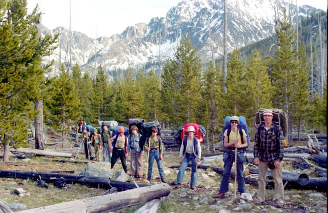
Our first day - Starting at Thirty Mile campground we headed up the Chewack River Trail, a long valley pounder. We then headed up the Basin Creek trail where this photo was taken (Day 1 -8 miles, 2300' climb). After reaching a campsite we realized that the high country was still snowed in and we needed to amend our trip plan for a lower elevation hike. (Photo location 1 - along the Basin Cr Trail).
enlarge 257KB, 800x556 6 Troop tradition was to give nicknames on our hikes so here we have: "Cascade" Bill Mooseker Pat "Hootin' Hippie" Haller Matt "Galloping Gourmet" Guentz Randal "Golden Day" Fenton Mike "Rootin Tootin Regular" Ruhsenberger Scott "Sweat Sox" Weatherhogge Merle "Mountain Man" Weatherhogge
(Not shown:) Greg "Wait for Me" Mooseker Craig "Cowpie" Koch Randy "50 and Out" Miller Dave "Malibubu" Burgess
enlarge 224KB, 800x538 7 Pat, Merle, Greg, Randy and Matt
This is the morning of our 3rd Day - For Day 2 we had a short hike back down Basin Creek and up the Chewack (Photo Location 2 - See Map) to the junction of the Chewack River and Horseshoe Creek.
enlarge 198KB, 800x540 8 Matt "Galloping Gourmet" Guentz cooking up a bunch of Vienna Sausages.
The Paseyton seems to attract wierd hikers, and while we were getting breakfast, a guy, whom we dubbed "The Spaceman", walked up to our camp dressed in aluminum foil and transparent plastic and asked us if there was a bridge. We pointed out a sign just over our heads that said "Bridge" with an arrow pointing the way. He walked off into the drizzle and was never seen again. I wish now that I had taken a picture of him, but you don't want to provoke wierd people!
enlarge 186KB, 800x537 9 Merle, Greg, Mike, and Randy. - Waiting for breakfast.
That's his old orange pack on the tree - The pack fell apart about 5 days into the hike and we had to come up with a Rube Goldberg fix in the field so he could finish the trip.
enlarge 233KB, 800x518 11 Taking a Break - Pat, Randal, Dave, Scott, Greg, Craig, Mike, and Merle. (Photo Location 3 - See Map.)
enlarge 258KB, 541x800 12 Getting Ready to head out - Merle, Randy, and Matt
enlarge 299KB, 800x520 13
Day 3 was a long slog up the Chewack (10 miles, 2200' climb). Near the end we got glimpses of Remmel Mountain through the trees.
enlarge 282KB, 800x519 14
Along the Trail - Remmel Mountain as a backdrop: Dave, Greg, Pat, Randal, Craig, Randy, Mike, Matt, Scott, and Merle. (Photo Location 4 - See Map)
enlarge 264KB, 800x517 15 Another View.
enlarge 210KB, 800x519 16
At last the trail exits the woods and enters the meadows on the south side of Remmel Lake (Elev 6871' - Photo Location 5 - See Map). Greg "Wait for Me" Mooseker got his nickname as he was almost always the last one ready to hit the trail. You can see the weather, had turned cold causing Greg to don stocking cap and sweater.
enlarge 244KB, 900x544 17
We camped on the north side of Remmel Lake with a good view of Remmel Peak. (Photo Location 6 - See Map), and watched the clouds and showers roll by.
enlarge 223KB, 800x526 18 Another View
enlarge 161KB, 800x513 19 Sunset at Remmel Lake.
enlarge 181KB, 900x553 20 Another view.
enlarge 150KB, 800x510 21 View from the south side of Remmel Lake towards Amphitheater Mtn.
enlarge 233KB, 800x516 22
Day 4 - we took a day hike to Cathedral Lake. This is just above Remmel Lake below Amphitheater Mtn. with a grand view of Remmel Peak. (Photo Location 7 - See Map).
enlarge 224KB, 800x516 23 Another view.
enlarge 211KB, 800x520 24 View of Remmel Peak (left) and Andrew Peak to the right from the meadows above Remmel Lake (Photo Location 7 - See Map).
enlarge 196KB, 800x516 25 Randal and Matt with Remmel Mtn as backdrop.
Randal "Golden Day" Fenton got his nickname because he would always be saying "It's going to be a Golden Day" (from the Bad News Bears or the Coke commercial?) even though it was usually raining or snowing.
enlarge 175KB, 800x514 26
Cascade Bill back when there weren't any gray hairs in the beard. That was a great hiking stick I got at a craft fair - super light and flexible, but after a few years of hard use, I accidentally stepped on it and it broke in half.
enlarge 165KB, 800x526 27 As we climbed higher we got into heavy snowpack. This is looking west towards Sheep Mountain.
enlarge 233KB, 800x522 28
After a while the trail from Remmel Lake joins the Boundary trail and goes over a little pass for a view of Cathedral Peak.
enlarge 250KB, 556x800 29 Cathedral Peak and Lake from the trail.
enlarge 240KB, 800x532 30 A good view of Cathedral Pass above the Lake - I would come over that pass in 1984.
enlarge 225KB, 526x800 31 Mike, Pat, Scott, Randal and Greg. - you can see that it was cold.
We continued west on the Boundary Trail till we got a view of Lower Cathedral Lake (visible through the trees here). Because of the snow we turned around and headed back to Remmel Lake. (Photo Location 8 - See Map)
enlarge 135KB, 800x526 32
Heading back across the snow fields, which were sometimes knee deep. Scott, who had a new pair of $100 dollar boots that he swore were 100% waterproof, came walking into camp and you could hear "Squish", "Squish" with every step, claimed that the boots hadn't leaked, but that his feet were sweating a lot - thus the nickname "Sweat Sox" Scott.
"I will have to remember that one if my new waterproof..." View Comments...
enlarge 130KB, 800x526 33 Remmel Peak from the snowfields.
enlarge 232KB, 800x515 34
Craig and Randy around the campfire after a long day hike. They regailed us with a long story about how they had snuck out one night and their adventures on the town, including encounters with a drug dealer.
enlarge 221KB, 800x555 35 Close up of Craig and Randy
Craig got the nickname of "Cowpie" from the numerous cowpies found in the "Multi-use" National Forest, when he found that not all of them were dried out. Randy got his nickname "50 and Out", when we were hiking the next day and we turned off on the Spanish Creek trail, and I told him that we could just keep going down the Andrew's Creek Trail and get our 50 miles in. He said that that sounded like a good idea to him.
enlarge 263KB, 800x527 36 Sitting around the campfire at Remmel Lake: Randal, Mike, Greg, Merle, Matt, Pat, Randy, Bill, Scott, Craig, and Dave.
It was cold and we even had snow at times. It's funny how you can't remember what you did yester day, but I remember discussions around this campfire that was decades ago. We talked about the wonderful new product the "Walkman" that you could clip to your belt and take your music with you. Merle also informed us that his daughter was going to going to junior high in the fall and that they guys were to look out for her. Scott also took a lot of guff for his waterproof boots.
enlarge 253KB, 800x523 37
Another view. If you enlarge the picture to "Original view", you can see my old single wall "A" frame tent at the right.
enlarge 197KB, 529x800 38
This is from a day hike up Bald Mountain on Day 6 looking west to Sheep Mountain. What happened to Day 5, you might ask? Well, it was one of the most miserable hiking days I've ever had. The Boundary Trail goes over Bald Mountain, but all we could see was white snow covering the mountain so we opted to bypass Bald Mtn by taking the Spanish Creek Trail - 9 miles of pure hell. Mud, Mud, Mud! Creek Crossings on slippery logs - Craig fell in at one point. It was so bad we didn't get any pictures)
enlarge 211KB, 800x521 39 Bill, Merle, Mike, Pat, and Craig on the Boundary Trail over Bald Mtn.
View is to the west towards Sheep Mountain. Much to my chagrin, I found that there was no snow on the trail, which skirted the north side of the mountain avoiding the snow we had seen on our day hike to Cathedral Lake.
enlarge 187KB, 800x518 40 Another view from Bald Mountain, looking south. (Photo Location 10 - See Map)
enlarge 281KB, 744x800 41 We came upon this fawn hiding among the limbs of this fallen tree. (Enlarge to Original Size")
enlarge 296KB, 800x521 42 Another view of the fawn.
enlarge 195KB, 800x522 43 Bald Mountain has a long flat meadow on top and we took a break at this big boulder- Bill, Pat, Craig, Randy, Mike, and Merle.
enlarge 234KB, 661x800 44 Bill and Greg (I got a picture at this same spot in 1996 with my younger son, Andrew)
enlarge 227KB, 800x599 45 Bill and Greg - Note this was before the advent of fleece. In 1981 it was wool only!
enlarge 213KB, 526x800 46 Pat Haller
enlarge 231KB, 800x600 47 Close up of Hootin Hippie Haller.
enlarge 212KB, 526x800 48 Mike Ruhsenberger
enlarge 214KB, 800x599 49 Close up of "Rootin Tootin Regular" Ruhsenberger. Mike got his nickname from eating the left over portions of "stewed fruit" that we had for breakfast and dessert. Merle didn't eat his portions, explaining that, "I don't mind being regular, I just don't want to be frequent!"
enlarge 202KB, 800x599 50 Craig "Cowpie" Koch
enlarge 219KB, 800x600 51 Randy "50 and Out" Miller.
enlarge 324KB, 800x518 55 Matt, Scott, Randal, and Dave had stayed in camp while we went on our day hike.
enlarge 326KB, 800x526 56 Matt, Scott, Randal, and Dave building a "bridge" over the Ashnola River.
enlarge 332KB, 800x599 57 Close up - The Ashnola River flows north, which feels a little strange.
enlarge 233KB, 800x526 58 Merle, Randy, Pat, Dave, Randal, Scott, Greg, Craig, and Mike (Photo Location 10 - See Map)
We camped two nights at the Ashnola Shelter, which is in a small grassy clearing in the middle of a dense Lodgepole pine forest. Because of it's remoteness, and being surrounded by a dark forest, it makes one feel that he is back in time with Daniel Boone on the frontier. I've stayed here many times since- 1984, 1996, and 2001.
enlarge 222KB, 800x526 59 Around the campfire at the Ashnola Shelter - Randy, Pat, Dave, Scott, Greg, and Matt.
After our long muddy hike up the Ashnola and over Ashnola pass, we renamed it the "Assahola" River. One of the topics at our campfires was usually movies, etc. Dave got his nickname "Malibubu" because he always put in a plug for "Malibu Beach" with its big breasted babes in bikinis. You can find the trailer here: Malibu Beach
enlarge 239KB, 800x526 60
After a long 16 mile day up the Ashnola and over Ashnola pass we valley pounded down Lake Creek to beautiful Black Lake. Both "Hootin Hippie" and "Wait for me" had fallen in the Asnhola river. My feet felt like I had walked through a lava pool. All the camps at the north end of the lake were taken so we had hike all the way to the south end much to the dismay of my feet.
enlarge 228KB, 547x800 61 Another view - (Photo Location 11 - See Map).
enlarge 209KB, 800x520 62
A view looking back up Black Lake - We were heading out just as the weather turned beautiful. Just 3.5 miles out to the cars, and a long drive home after porking out in Winthrop. (Photo Location 12 - See Map).