 On the summit of Mt Pitt (316m) On the summit of Mt Pitt (316m)
Mt Pitt (316m) and Mt Bates (318m) are both remnants of a long-extinct volcano and form the two highest points on Norfolk Island.
|  On the summit of Mt Pitt (316m) On the summit of Mt Pitt (316m)
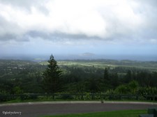
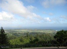
The open area at the summit of Mt Pitt gives a commanding view of the whole island, and hopefully the cloud will soon clear.
|  Ray of Sunshine on Airstrip Ray of Sunshine on Airstrip
From the summit of Mt Pitt.
|  Looking South from Mt Pitt Looking South from Mt Pitt
|
 Looking South West from Mt Pitt Looking South West from Mt Pitt
|  Looking to West from Mt Pitt Looking to West from Mt Pitt
|  Looking North West from Mt Pitt Looking North West from Mt Pitt
|  Looking North to Mt Pitt Road Looking North to Mt Pitt Road
|
 Communications Towers on Mt Pitt Communications Towers on Mt Pitt
|  Silhouette of Norfolk Island Pines Silhouette of Norfolk Island Pines
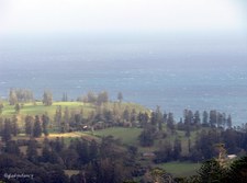
|  Zoomed to Phillip Island Zoomed to Phillip Island
Vegetation on Phillip Island became denuded by the Rabbits which were introduced by the early settlers. An eradication program began in the 1970's and resulted in the last rabbit being exterminated in 1988. Regeneration of native species has resulted in vegetation now flourishing in many places.
|  Burnt Pine Township Burnt Pine Township
|
 Overlooking National Park Overlooking National Park
Easterly from Mt Pitt.
|  Overlooking National Park Overlooking National Park
Easterly from Mt Pitt
|  Overlooking National Park and Settlements Overlooking National Park and Settlements
South Easterly from Mt Pitt.
|  Overlooking National Park and Settlements Overlooking National Park and Settlements
South Easterly from Mt Pitt.
|
 Overlooking Burnt Pine from Mt Pitt Overlooking Burnt Pine from Mt Pitt
|  Phillip Island just visible on horizon Phillip Island just visible on horizon
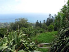
|  Many shades of Green Many shades of Green
Foreground Vegetation on Mt Pitt.
|  View to Rocky Point and Pacific Ocean View to Rocky Point and Pacific Ocean
|
 Lush Green Plants have best view on the Island Lush Green Plants have best view on the Island
Broad-Leafed Meryta (Meryta latifolia) and Cordylines.
|  Sunshine and Shadow continually moving Sunshine and Shadow continually moving
|  Framed by Norfolk Island Flax Framed by Norfolk Island Flax
|  View beyond Cordylines and Flax View beyond Cordylines and Flax
|
 Foreground of Cordylines Foreground of Cordylines
|  Landscape dotted with Norfolk Island Pines Landscape dotted with Norfolk Island Pines
|  Pacific Ocean to the West Pacific Ocean to the West
|  Flax and other Vegetation Flax and other Vegetation
|
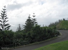
 Silhouette of Norfolk Island Pines beside Mt Pitt Road Silhouette of Norfolk Island Pines beside Mt Pitt Road
The first road to the summit of Mt Pitt was built by convicts and much steeper. The current road was first constructed during World War II, and reconstructed in 2003.
|  Plaque Plaque
This plaque commemorates the re-opening of the Mt Pitt Road in August 2003. Funding for the reconstruction was provided by the Australian Government.
|  View from Mt Pitt View from Mt Pitt
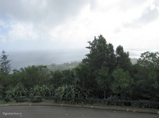
Clouds are clearing, so a few more photos of the scenic views before boarding the bus again.
|  View from Mt Pitt View from Mt Pitt
|
 View from Mt Pitt View from Mt Pitt
|  View from Mt Pitt View from Mt Pitt
|  View from Mt Pitt View from Mt Pitt
|  View from Mt Pitt View from Mt Pitt
|
 Marsden Matting used for Fence Marsden Matting used for Fence
Marsden Matting is standardized, perforated steel matting material originally developed by the United States at the Waterways Experiment Station shortly before World War II, primarily for the rapid construction of temporary runways and landing strips.
|  Marsden Matting used for Fence Marsden Matting used for Fence
The typical Marsden matting was the M8 landing mat. A single piece weighed about 66 pounds and was 10 feet (3.0 m) long by 15 inches (380 mm) wide. The hole pattern for the sheet was 3 holes wide by 29 holes long resulting in 87 holes per mat. During World War II, Marsden Matting was used to construct the airstrip on Norfolk Island.
|  Oranges and Epiphytes Oranges and Epiphytes
On tree above the Marsden Matting Fence.
|  Iwii Paradise on Cascade Road Iwii Paradise on Cascade Road
Includes Cafe, Military Museum, Art Gallery, Retail Shop, Souvenirs, and wonderful views across Norfolk Island.
|
