 Orientation Tour Orientation Tour
The first of many excellent tours with Pinetree Tours.
|  Norfolk Island School Norfolk Island School
Students are educated in accordance with the NSW Curriculum and the Teachers are appointed on a 3-year term from NSW. Norfolk Island is a popular posting for teachers.
|  Leaving the Burnt Pine Township Leaving the Burnt Pine Township
|  Cattle Grid Cattle Grid
Most properties have a cattle grid at the entrance to prevent cattle passing through.
|
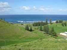
 Green Hills and Valleys Green Hills and Valleys
Along Rooty Hill Road.
|  Ocean View from Rooty Hill Road Ocean View from Rooty Hill Road
|  Cemetery and Golf Course Cemetery and Golf Course
Overlooking Kingston, taken from Queen Elizabeth Lookout on Rooty Hill Road.
|  Cemetery on Emily Bay Cemetery on Emily Bay
Overlooking Kingston, taken from Queen Elizabeth Lookout on Rooty Hill Road.
|
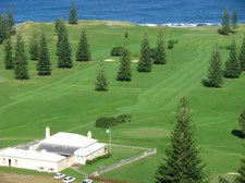 Golf Course and Golf Club House Golf Course and Golf Club House
The Golf Club House was formerly the Stipendiary Magistrate's Quarters. Overlooking Kingston, taken from Queen Elizabeth Lookout on Rooty Hill Road.
|  Nepean and Phillip Islands Nepean and Phillip Islands
Overlooking Kingston, taken from Queen Elizabeth Lookout on Rooty Hill Road.
|  Information and Map Information and Map
Overlooking Kingston, taken from Queen Elizabeth Lookout on Rooty Hill Road.
| 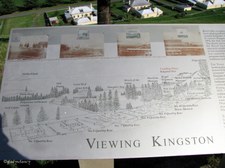 Information and Map Information and Map
Overlooking Kingston, taken from Queen Elizabeth Lookout on Rooty Hill Road.
|
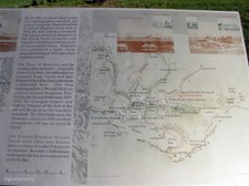 Information and Map Information and Map
Overlooking Kingston, taken from Queen Elizabeth Lookout on Rooty Hill Road.
|  Plaque Plaque
This plaque was unveiled by Her Majesty the Queen on the occasion of the Royal Visit to Norfolk Island in February 1974, the Bi-Centenary Year of the discovery of the island by Captain James Cook on 10 October 1774.
|  Historic Houses of Quality Row Historic Houses of Quality Row
The Quality Row houses comprise part of the most extensive remaining pre-1850 settlement street in Australia. Overlooking Kingston, taken from Queen Elizabeth Lookout on Rooty Hill Road.
|  Historic Kingston Historic Kingston
Overlooking Kingston, taken from Queen Elizabeth Lookout on Rooty Hill Road.
|
 The Islands beyond the Golf Course The Islands beyond the Golf Course
Overlooking Kingston, taken from Queen Elizabeth Lookout on Rooty Hill Road.
|  The Old Military Barracks The Old Military Barracks
Overlooking Kingston, taken from Queen Elizabeth Lookout on Rooty Hill Road.
|  Old Military Barracks Old Military Barracks
The terraced effect on the hillside is created by grazing cattle. Overlooking Kingston, taken from Queen Elizabeth Lookout on Rooty Hill Road.
|  Rooty Hill Road lined by Norfolk Pine Trees Rooty Hill Road lined by Norfolk Pine Trees
Overlooking Kingston, taken from Queen Elizabeth Lookout on Rooty Hill Road.
|
 Norfolk Island Pines complete the picture Norfolk Island Pines complete the picture
Overlooking Kingston, taken from Queen Elizabeth Lookout on Rooty Hill Road.
|  Another view from the lookout Another view from the lookout
Overlooking Kingston, taken from Queen Elizabeth Lookout on Rooty Hill Road.
|  Yet another view of this pretty island Yet another view of this pretty island
Overlooking Kingston, taken from Queen Elizabeth Lookout on Rooty Hill Road.
|  Old Military Barracks Old Military Barracks
A fine example of 1830's British military architecture. Designed by William Buchanan in 1826 as a two-storey building with verandahs to accommodate 100 men. Completed in 1834, the complex was surrounded by a high stone wall, rectangular in plan, with corner turrets.
|
 Old Military Barracks Old Military Barracks
This historical building now serves as the chambers and offices of the Norfolk Island Legislative Assembly.
| 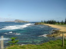 Coastal View Coastal View
Taken through the window of the bus.
|  The Lush Green of the Golf Course The Lush Green of the Golf Course
| 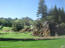 Rocky Outcrop on Reserve Rocky Outcrop on Reserve
|
 Ocean View Ocean View
From eastern end of Emily Bay.
|  View across Emily Bay View across Emily Bay
|  Across the water Across the water
Against the sun towards Kingston Pier.
| 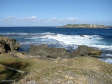 Nepean Island Nepean Island
A limestone islet of about four hectares and 2 km south of Norfolk Island.
|
 Nepean Island and Phillip Island Nepean Island and Phillip Island
Phillip Island is an irregularly shaped rugged volcanic island more than 2 kms long and 7 km south of Norfolk Island.
|  Rugged Coastline of Volcanic Rock Rugged Coastline of Volcanic Rock
|  Near Kingston Pier Near Kingston Pier
Old Lighter near Boatshed, and Nepean Island on the horizon.
|  Kingston Pier on the south Kingston Pier on the south
Note small fishing boat about to be winched ashore.
|
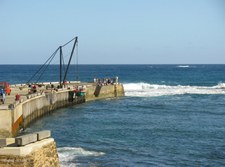 Kingston Pier Kingston Pier
Small fishing boat being lifted out of the water. All cargo comes ashore in this manner.
|  Coastline west of Kingston Pier Coastline west of Kingston Pier
|  Hillside cutting for access road to Cascade Pier Hillside cutting for access road to Cascade Pier
|  Cascade Pier on the north Cascade Pier on the north
As Norfolk has no harbour, ships stand about a kilometre off shore from Kingston or Cascade, according to where the swell is coming from, and lighters are sent out to pick up passengers or cargo.
|
