 Map of Puebla and Veracruz states Map of Puebla and Veracruz states
Map highlighting the towns we visited.
|  View of Cholula's "Nuestra Senora de los Remedios" Church View of Cholula's "Nuestra Senora de los Remedios" Church
| 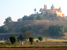 View of Cholula's "Nuestra Senora de los Remedios" Church View of Cholula's "Nuestra Senora de los Remedios" Church
This church, translated as "Our Lady of the Remedies", unbelievably sits atop a hillside covering the largest (by volume) pyramid in the world.
|  View of Mt Popocateletl View of Mt Popocateletl
On a clear day (and with an excellent deep-focus camera), Mexico's second highest peak (18,000 feet) can be viewed from the covered pyramid's hilltop. We never saw this dramatic view; it was too hazy. This is scanned from a postcard.
|
 Pyramid Pyramid
This diagram (from the Blue Guide to Mexico) shows the successive enlargements of the pyramids beneath the hill. The first pyramid was estimated to have been constructed in 200AD; the last, in the 12th century.
|  Tunnel entrance Tunnel entrance
The only way to glimpse the original pyramids is to enter one of the tunnels carved into the hillside.
| 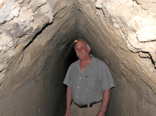 Tunnel Tunnel
There is a network over 5 miles of tunnels beneath the hill. But only about 1,000 feet of these tunnels are accessible to tourists.
|  More Tunnels More Tunnels
In 1934, archeologists first discovered the pyramids hidden beneath the church.
|
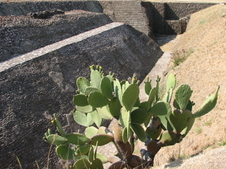 Exterior site excavation Exterior site excavation
Outside the tunnels, some recent excavation work can be viewed.
|  Portales along Cholula's zocalo Portales along Cholula's zocalo
When Cortes first viewed the city of Cholula, he reportedly called it "the most beautiful city outside Spain". The set of 46 portales (seen here) lining one side of the main plaza is said to be the longest in Latin America. Cholula's zocalo (main plaza) is the second largest plaza in Mexico.
| 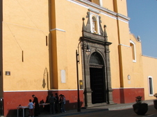 Parroquia de San Pedro Parroquia de San Pedro
In 1519, when Cortes heard about a plot by the Aztecs of Cholula to ambush the Spanish, the Spaniards took their revenge: they massacred between 5,000 and 10,000 Cholulans. Cortes then vowed to build 365 churches - one for each day of the year - in Cholula. But he succeeded in building only 39 - mainly atop ancient ruins.
| 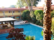 Villa Arqueologica Villa Arqueologica
Villa Arqueologica (once managed by Club Med), where we stayed in Cholula, was a peaceful oasis with a welcoming pool. And it was only about a 10-minute walk to the archeological site and a 15-minute walk to the zocalo.
|
 Puebla's zocalo Puebla's zocalo
This city, founded in 1531, was originally named Puebla de los Angeles - the city of Angels. The Spanish wanted it to surpass the beauty of nearby Cholula. Cinco de Mayo commemorates the Battle of Puebla (May 5, 1862) where the Mexicans won a decisive battle against the French.
|  Chess girls Chess girls
A chess tournament was in progress in the zocalo during the first Sunday we were in Puebla. In Puebla, Hotel Colonial is a traditional hotel right off the zocalo. Rooms vary widely. See a couple before choosing.
|  Balloons and clown Balloons and clown
|  Clown close-up Clown close-up
|
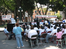 Demonstration Demonstration
There were several demonstrations in the zocalo protesting the government's decision to sell shares of Pemex (the government-owned oil company) to outside companies (from the United States).
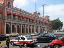
|  Puebla building Puebla building
This city of over 1.9 million (the third largest in Mexico) has a large, beautifully restored colonial center. Puebla was honored as a UNESCO World Heritage Site in 1987.
|  Mexico08 011a Mexico08 011a
|  Street vendor Street vendor
Origami for sale in Puebla.
|
 Origami close-up Origami close-up
|  Courtyard of Posada del Cafeto in Xalapa Courtyard of Posada del Cafeto in Xalapa
View from our room of the courtyard of this charming hotel Posada del Cafeto
|  Exterior of the hotel in Xalapa Exterior of the hotel in Xalapa
In the late 1980's, Xalapa grew from a small town of 30,000 into a city of nearly 500,000 in a few short years. Traffic throughout this hilly town is a nightmare.
|  Callejon del Diamante Callejon del Diamante
A pedestrian side street filled with street vendors and small restaurants. There are several pedestrian alleys scattered throughout the town center.
|
 Downtown Xalapa Downtown Xalapa
View of the Palacio de Gobierno near Parque Juarez in the heart of Xalapa.
|  Museo de Antropologia de Xalapa Museo de Antropologia de Xalapa
"El Rey" (The King), the largest of the museum's seven colossal basalt Olmec heads. It is estimated to weigh more than 20 tons.
|  Olmec Head detail Olmec Head detail
These heads are approximately 3,000 years old.
|  Olmec head Olmec head
The museum's layout was inspired by the shape of the state of Veracruz. The "niche-shaped" windows are meant to evoke the designs at El Tajin.
|
 Veracruz zocalo Veracruz zocalo
Cortes made his first landing in Mexico on an island offshore of present-day Veracruz. Today, the zocalo is the heart of the action in this city of over 500,000.
|  Gran Cafe in Veracruz Gran Cafe in Veracruz
Gran Cafe de la Parroquia is one of the cafe traditions in Veracruz. People hang out for hours here sipping coffee, reading newspapers or catching a quick bite to eat.
| 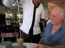 Cafe lechero Cafe lechero
But the main draw here is to order cafe lechero. First, a small amount of deep, rich, black coffee is delivered to your table in a tall glass; then, by clinking your spoon against the glass, you'll signal a waiter to come to your table; he will pour -often from a great height - a stream of steaming milk from a large kettle into your glass. Amazingly, he doesn't miss.
|  Exterior of our hotel in Veracruz Exterior of our hotel in Veracruz
We stayed in one of the multi-level, spacious rooms at the Meson del Mar in downtown Veracruz.
|
 Papantla main square Papantla main square
The steep, hillside town of Papantla is in the heart of Mexico's vanilla-growing region. It is also home the voladores who, on Sundays, spin down from the skinny 82-foot pole which looms above the church tower. The voladore monument can be seen couched between the tower and the pole.
|  Papantla Map Papantla Map
No map of Papantla could be found in any guidebook. This was obtained from the tourist office. It is basic but serviceable. We stayed at Hotel Tajin
|  Voladore monument at sunset Voladore monument at sunset
The 1988 El momumento al Volador (to be precise) hovers above Papantla on its highest hill. It was erected to honor the voladores (meaning "the ones who fly").
|  Voladore monument Voladore monument
The statue features a voladore caporal (or captain) playing his three-holed flute (chirimia) in preparation for the four other flyers to launch their dizzying flight.
|
 Voladore close-up Voladore close-up
Totonac voladores perform to honor the four directions of the earth. It is an acrobatic but solemn ritual. It was originally only performed once every 52 years to celebrate the beginning of a new calendar.
|  Voladores in flight (Postcard View) Voladores in flight (Postcard View)
Before they ascend, the voladores begin with a ritual dance around the pole. Then, they climb the pole. Atop the pole, the caporal plays his flute and drum. The four others tie ropes around their waists and drop backwards as the wood frame begins to turn. They spin left 13 times for a total of 52 rotations among the four voladores.
|  Pyramid of the Niches Pyramid of the Niches
Of the 150 structures that have been identified at El Tajin, only 20 have been excavated and restored. Probably the most famous of them all is this iconic building.
|  Pyramid of the Niches Pyramid of the Niches
The 60-foot high pyramid was originally thought to have been covered with red-painted stucco. The interior of the niches were thought to have been colored black.
|
