 Site of the 1788 Government House Site of the 1788 Government House
This timber building on the crest above the Landing place near Kingston Pier was occupied by civil officers during the second settlement, and is now used by the Lions Club.
|  Stone Plaque Stone Plaque
Marking the "Site of the 1788 Government House".
|  Surgeon's Quarters Surgeon's Quarters
The two apartments were occupied by the Surgeon and the commissariat officer.
| 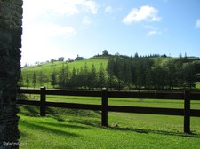 Looking north to the hills above Kingston Looking north to the hills above Kingston
|
 Commissariat Store in distance Commissariat Store in distance
The All Saints Church, formerly the Commissariat Store is the largest building in Kingston and was erected in 1835. Also used as a museum and storage for a vast amount of excavated material.
|  View across the wetlands View across the wetlands
Flocks of Geese are often seen here.
|  Circular Stone Well Circular Stone Well
|  Longridge Road Information Longridge Road Information
|
 Flagstaff Hill Walk Flagstaff Hill Walk
Insufficient time to attempt this walk.
|  Memorial Seat on Flagstaff Hill Walk Memorial Seat on Flagstaff Hill Walk
Syd "Guv" Christian 1927-1998.
|  Historic Georgian Buildings of Kingston Historic Georgian Buildings of Kingston
From base of Flafstaff Hill Walk. In the early 1960's a program of conservation of the early buildings and ruins was commenced. The work is funded jointly by the Commonwealth and Norfolk Island governments, and is now administered by the Kingston and Arthur's Vale Historic Area Management Board, which comprises representatives of each government. The Kingston and Arthur's Vale Historic Area is on the Register of the National Estate and is of international heritage significance.
|  Overlooking Kingston Overlooking Kingston
The restored Georgian buildings are used in many ways; museums, administration and legislative purposes, church, dwelling houses, clubhouse and theatre. The outdoor areas have many public amenities.
|
 Approaching Kingston Pier Approaching Kingston Pier
Nepean Island on horizon.
|  Kingston Pier Kingston Pier
In the early days of the Second Settlement, a landing place was established at a point beside the site of the present pier. Construction of Kingston Pier commenced in 1839 and was completed in 1847. It still functions today as the primary site for shipping, both overseas and local.
|  Kingston Pier Kingston Pier
As Norfolk Island has no harbour, ships stand about a kilometre off shore and lighters are sent out to pick up passengers and cargo.
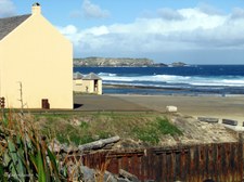
|  Coastline west of Kingston Pier Coastline west of Kingston Pier
|
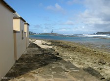 Coast east of the Kingston Pier Coast east of the Kingston Pier
Flaghouse Buildings and Seawall.
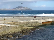
|  Phillip Island Phillip Island
Seven kilometres south of Norfolk, the uninhabited Phillip Island rises to a height of 274 metres. The island is about 2 kms long and nearly 2 kms wide. Twelve species of seabirds are listed as breeding on the island.
|  Phillip Island by 10 x zoom Phillip Island by 10 x zoom
Vegetation on Phillip Island became denuded by the Rabbits which were introduced by the early settlers. An eradication program began in the 1970's and resulted in the last rabbit being exterminated in 1988. Regeneration of native species has resulted in vegetation now flourishing in many places.
|  The Crankmill The Crankmill
The Crankmill comprises the remains of the only known pre-1850 human-powered crankmill in Australia. It was built as a two-storey granary in 1827. A cranking mechanism, hopper and grindstones for grinding maize were installed in 1837. The equipment was worked as punishment by a hundred convicts in irons. After 1856 the building was gutted by fire.
|
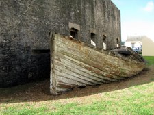 Old Lighter beside Crankmill Ruins Old Lighter beside Crankmill Ruins
Similar scenes are featured on many postcards, but it was unfortunate that a car was allowed to park where it spoilt the picture.
| 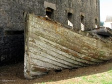 Closer view of Old Lighter Closer view of Old Lighter
|  Single Boatshed and Flaghouses Single Boatshed and Flaghouses
|  Flaghouse Information Flaghouse Information
|
 Interior of Flaghouse Interior of Flaghouse
The Flaghouse was built in the early 1840's to store the settlement's collection of multi-coloured flags. The ships were signalled by colour coded flags until the 1950's.
|  Double Boatshed and Lighter Double Boatshed and Lighter
The Double Boatshed provides a rare example of a building of its type and age. It was built in 1841 as a temorary shed on the site of an old barn and accommodated two 8 to 14 ton launches and two 6-oared whaleboats.
|  Pier Store built 1825 Pier Store built 1825
Now houses Norfolk Island Museum. Displays include the artefacts from the flagship of the First Fleet, HMS Sirius, shipwrecked off Kingston in 1790; a cannon and copper kettle from HMS Bounty; also artefacts brought from Pitcairn Island in 1856.
|  Restored Buildings of Kingston Restored Buildings of Kingston
|
 Near Crankmill Ruins Near Crankmill Ruins
|  Royal Engineer's Office built 1851 Royal Engineer's Office built 1851
Located near Kingston Pier, this building contains a cafe, books, postcards, etc. relevant to the history of the Island.
|  The Overseer's Quarters The Overseer's Quarters
| 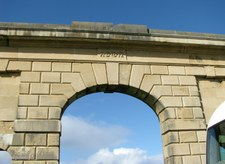 Arched entrance of New Gaol Arched entrance of New Gaol
Building commenced in 1836 but the main block was not completed until 1847 because of conflicting opinions over the design.
|
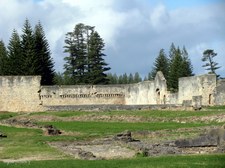
 Wall of New Gaol Wall of New Gaol
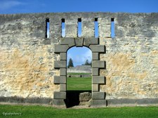
|  Entrance to New Gaol Entrance to New Gaol
Constructed on a radial plan, it contained 84 cells, two lock up rooms, 10 turnkeys' rooms and 10 yards. The prisoners worked in chains on the roads or at the quarries.
|  Inside the Walls Inside the Walls
Remaining foundations of the cells. Over the years, internal walls have been removed to provide stone for other building purposes on the Island.
|  From the Inside looking Out From the Inside looking Out
|
 Double Row of Cells was here Double Row of Cells was here
|  Information Plaque Information Plaque
|  Sewer Drain flushed by the Tidal Flow Sewer Drain flushed by the Tidal Flow
|  Remains of Isolation Cells Remains of Isolation Cells
|
