 Map of Argentina Map of Argentina
We began in Buenos Aires and flew down to El Calafate, then to Ushuaia and finally back to Buenos Aires.
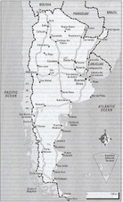
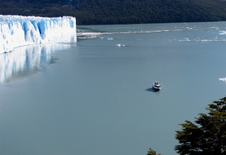
|  First view of Perito Moreno First view of Perito Moreno
Los Glaciares Park covers over 1.5 million acres and is home to over 300 glaciers. It was declared a World Heritage region by UNESCO in 1981.
|  Closer glimpse Closer glimpse
Perito Moreno is one of only two advancing glaciers in South America. This river of ice snakes 20 miles down from its source high in the Andes.
|  Getting closer Getting closer
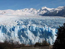
The front of the glacier is nearly 3 miles wide and towers 200 feet above the water.
|
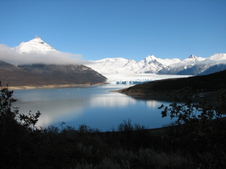
 Boat trip to the front of the glacier Boat trip to the front of the glacier
A 40-seat launch periodically leaves from Bahia Bajo for a 1 hour tour along the face of the glacier.
|  Near the front of the glacier Near the front of the glacier
The boat can go within about 500 feet of the front of the glacier.
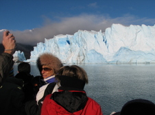
|  Photo Op Photo Op
On warmer and sunnier days there is more frequent "calving" or breaking off of the ice along the face of the glacier. Although the day was sunny, it was still too chilly to see any calving.
|  View from a walkway View from a walkway
A series of wooden walkways allow for viewing of the glacier from above. To fathom the size of the glacier, look for the person dressed in red at the bottom center of the photo.
|
 Another walkway view Another walkway view
The mountain peaks surrounding the glacier are commonly known as "the ghosts" because they are rarely visible - most often enshrouded by clouds. Only 10 to 15 days a year are clear enough to see them. Boo!
|  Still another view Still another view
It was noted that the entire city of Buenos Aires (the 11th largest city in the world) could comfortably fit into the area covered by this glacier. And this is not the largest glacier in the park!
|  Glacier with boat Glacier with boat
The green water that surrounds most glaciers is known a "glacial milk". Its greenish color is due to the mineral particles carried by the glacier and then transferred to the water as the ice melts.
|  Head shot Head shot
You are actually able to trek on the glacier. But unfortunately, in winter no treks were being led.
|
 View of a glacier high in the mountain View of a glacier high in the mountain
Glaciers are rivers of ice formed by the accumulation of snow. Each new layer of snow compresses the older layers. Gradually, the air pockets within the snow get smaller and smaller. The snow becomes more compact. Over time, the snow becomes denser - transforming itself into glacial ice.
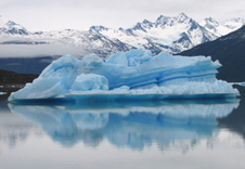
|  Spegazzini Glacier Spegazzini Glacier
Spegazzini Glacier is the highest glacier in the park. This day we saw no sun. But because it was a cloudy day, the blue of the ice was more vivid than on a sunny day.
|  Iceberg portrait Iceberg portrait
The arms of Lago Argentino were littered with icebergs. These icebergs are formed when a mass of ice breaks away ("calves") from the front of a glacier.
|  Another tour boat passing an iceberg Another tour boat passing an iceberg
The intensity of bluish color in an iceberg is dependent on the amount of compression in the ice as well as the refractive quality of the light.
|
 Close encounter with an iceberg Close encounter with an iceberg
It must be remembered that only about 15% of an iceberg's actual size is visible above the water; the remaining 85% is "hiding" beneath the surface.
|  Iceberg with arch - view 1 Iceberg with arch - view 1
Apart from the wooded mountainous shores that lined this channel, this area felt like it could be Antarctica.
| 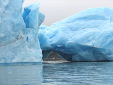 Iceberg with arch - view 2 Iceberg with arch - view 2
The cerulean blue glow emanating from these "bergs" appeared as if they were lit from within.
| 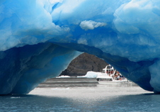 Iceberg with arch - view 3 Iceberg with arch - view 3
Another tour boat can be glimpsed under the arch of this iceberg.
|
 Tierra del Fuego Map Tierra del Fuego Map
From El Calafate we headed down to the tip of Argentina.
|  Ushuaia Ushuaia
Ushuaia ("oosh-why-a") - is the southernmost city in Argentina. With a population of about 40,000, this town is nestled between the Beagle Channel and the mountains that tower behind it.
| 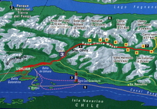 Ushuaia Map Ushuaia Map
We took a boat trip along the Beagle Channel (following the pink line on the map) as well as a day-trip into the mountains to Las Cotorras ski center.
|  View from the boat View from the boat
Heading away from Ushuaia late one afternoon, we began our 2-hour tour of the Beagle Channel.
|
 Beagle Channel Sea Lion Island Beagle Channel Sea Lion Island
The male sea lion can grow up to 11 feet in length; the females usually do not surpass 8 feet. They only eat fish - devouring between 33 and 55 pounds a day.
|  Isla de los Lobos Isla de los Lobos
Sea lions and comorants share this rocky island in the Beagle Channel.
|  Sea lion fun Sea lion fun
Of the sea mammals with both fins and feet (pinnipeds), the sea lions are the only ones that have ears.
|  Les Eclaireurs Lighthouse Les Eclaireurs Lighthouse
The 36-foot high Les Eclaireurs ("The Illuminators") Lighthouse, built in 1920, stands at the entrance to Ushuaia Bay.
|
 Chilly view of the lighthouse Chilly view of the lighthouse
|  Another lighthouse view Another lighthouse view
|  Storefront window display Storefront window display
A storefront display in Ushuaia used stuffed penguins (penniquins?) to model fleece jackets.
|  Close to Antarctica Close to Antarctica
Ushuaia lies only about 600 miles from the Antarctic shores. From November to March, many tour boats leave from Ushuaia boudn for Antarctica.
|
 Antarctica Antarctica
The Argentine claim in Antarctica.
| 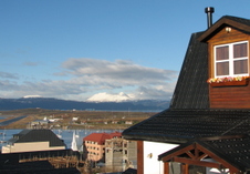 View from our hotel View from our hotel
Our hotel, Posada Fueguina, sat a few blocks up a steep hill - away from the main street of Ushuaia. Blissfully quiet with beautiful views over the Beagle Channel. Info at: http://www.posadafueguina.com.ar/
|  Yamana Yamana
The Yamana were the original inhabitants of the Tierra del Fuego region. As shown in this old postcard, the men often painted themselves with black carbon and white clay for ceremonial display. They wore little clothing even though they lived in such a harsh climate.
|  Dog-sledding Dog-sledding
We hired a dog sled at Las Cotorres ski area - about a half hour's drive northeast of Ushuaia.
|
 View from the front View from the front
View from the front seat of the dog sled.
|  Amateur driver Amateur driver
The driver let us both take turns steering the dog sled.
|  Snow shoes Snow shoes
We also rented snowshoes ("raquetas") for an afternoon.
| |
