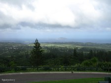
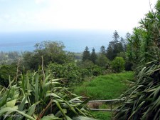
1
On the summit of Mt Pitt (316m)
Mt Pitt (316m) and Mt Bates (318m) are both remnants of a long-extinct volcano and form the two highest points on Norfolk Island.
| 
2
On the summit of Mt Pitt (316m)
The open area at the summit of Mt Pitt gives a commanding view of the whole island, and hopefully the cloud will soon clear.
| 
3
Ray of Sunshine on Airstrip
From the summit of Mt Pitt.
|

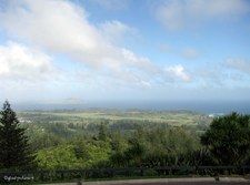
4
Looking South from Mt Pitt
| 
5
Looking South West from Mt Pitt
| 
6
Looking to West from Mt Pitt
|
7
Looking North West from Mt Pitt
| 
8
Looking North to Mt Pitt Road
| 
9
Communications Towers on Mt Pitt
|

10
Silhouette of Norfolk Island Pines
| 
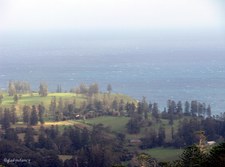
11
Zoomed to Phillip Island
Vegetation on Phillip Island became denuded by the Rabbits which were introduced by the early settlers. An eradication program began in the 1970's and resulted in the last rabbit being exterminated in 1988. Regeneration of native species has resulted in vegetation now flourishing in many places.
| 
12
Burnt Pine Township
|

13
Overlooking National Park
Easterly from Mt Pitt.
| 
14
Overlooking National Park
Easterly from Mt Pitt
| 
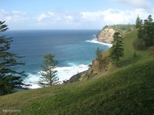
15
Overlooking National Park and Settlements
South Easterly from Mt Pitt.
|

16
Overlooking National Park and Settlements
South Easterly from Mt Pitt.
| 
17
Overlooking Burnt Pine from Mt Pitt
| 
18
Phillip Island just visible on horizon
|

19
Many shades of Green
Foreground Vegetation on Mt Pitt.
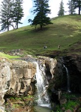
| 
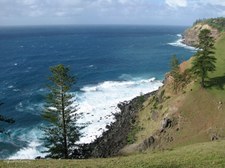
20
View to Rocky Point and Pacific Ocean
| 
21
Lush Green Plants have best view on the Island
Broad-Leafed Meryta (Meryta latifolia) and Cordylines.
|

22
Sunshine and Shadow continually moving
| 
23
Framed by Norfolk Island Flax
| 
24
View beyond Cordylines and Flax
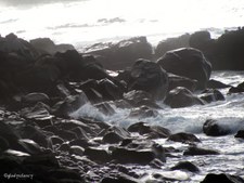
|

25
Foreground of Cordylines
| 
26
Landscape dotted with Norfolk Island Pines
| 
27
Pacific Ocean to the West
|

28
Flax and other Vegetation
| 
29
Silhouette of Norfolk Island Pines beside Mt Pitt Road
The first road to the summit of Mt Pitt was built by convicts and much steeper. The current road was first constructed during World War II, and reconstructed in 2003.
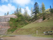
| 
30
Plaque
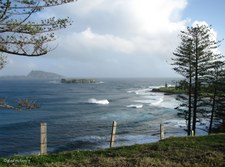
This plaque commemorates the re-opening of the Mt Pitt Road in August 2003. Funding for the reconstruction was provided by the Australian Government.
|

31
View from Mt Pitt
Clouds are clearing, so a few more photos of the scenic views before boarding the bus again.
| 
32
View from Mt Pitt
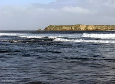
| 
33
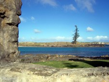
View from Mt Pitt
|

34
View from Mt Pitt
| 
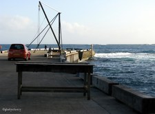
35
View from Mt Pitt
| 
36
View from Mt Pitt
|

37
Marsden Matting used for Fence
Marsden Matting is standardized, perforated steel matting material originally developed by the United States at the Waterways Experiment Station shortly before World War II, primarily for the rapid construction of temporary runways and landing strips.
| 
38
Marsden Matting used for Fence
The typical Marsden matting was the M8 landing mat. A single piece weighed about 66 pounds and was 10 feet (3.0 m) long by 15 inches (380 mm) wide. The hole pattern for the sheet was 3 holes wide by 29 holes long resulting in 87 holes per mat. During World War II, Marsden Matting was used to construct the airstrip on Norfolk Island.
| 
39
Oranges and Epiphytes
On tree above the Marsden Matting Fence.
|

40
Iwii Paradise on Cascade Road
Includes Cafe, Military Museum, Art Gallery, Retail Shop, Souvenirs, and wonderful views across Norfolk Island.
| 
41
View from Iwii Paradise
| 
42
View from Iwii Paradise
|

43
View from Iwii Paradise
| 
44
View from Iwii Paradise
| 
45
View from Iwii Paradise
|

46
'Spokes' inside Norfolk Island Pine Trunk
Decaying section of Trunk revealing 'spokes' pointing inwards from where the branches protruded. On display at Iwii Paradise.
| 
47
Detail on corner of House
Iwii Paradise.
| 
48
Clifftop end of Cascade Road
Norfolk Island Pine and White Oaks.
|

49
Cascade Road with cliffs in view
| 
50
Looking over the edge...
| 
51
Looking Inland to Cattle on rolling Hills
|
52
Coastline of Cascade Bay
| 
53
Coastline of Cascade Bay
| 
54
Coastline of Cascade Bay
|

55
Coastline of Cascade Bay
| 
56
Coastline of Cascade Bay
| 
57
Rolling Hills go down to the Sea
|

58
Bend in Cascade Road
| 
59
View between the Trees
| 
60
Last look down at the Coastline
Cascade Bay.
|

61
Along Prince Phillip Drive
| 
62
Curious Calf
| 
63
Walking beside the Stream
|

64
Cattle Grazing
They take no notice as we walk past.
| 
65
Crossed the Stream on Stones
(Wished I had longer legs)!
| 
66
Cascade Waterfall
|

67
The Water flows down to the Sea
| 
68
Hill rises beyond Cascade Waterfall
Some people watched from the other side.
| 
69
Cascade Waterfall
|

70
Cascade Waterfall
| 
71
Returning past the grazing Cattle
| 
72
Stopped to view a Stone Bridge
|

73
Upstream view from Stone Bridge
| 
74
Old Whaling Station Site in Cascade Bay
Looking towards Cascade Pier.
| 
75
Old Whaling Station Site
Cascade Bay.
|

76
Old Whaling Station Site
Cascade Bay.
| 
77
Rusted remains from Old Whaling Station
Cascade Bay.
| 
78
Rusted remains from Old Whaling Station
Cascade Bay.
|

79
Rusted remains from Old Whaling Station
Cascade Bay.
| 
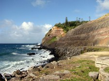
80
Hills and Valleys
Land rises steeply behind the site of the Old Whaling Station and Rock has been quarried from one hillside.
| 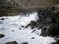
81
Waves Splashing
Cascade Bay.
|

82
Old Whaling Station Site
View towards Cascade Pier.
| 
83
Zoomed to Cascade Pier
Cascade Bay.
| 
84
Wet Rocks on Shoreline
|

85
House on a Clifftop
Overlooking Cascade Bay.
| 
86
Clifftop view of Cascade Bay
| 
87
Coastal view of Cascade Bay
From clifftop above the Cascade Pier.
|

88
Looking down on site of Old Whaling Station
Into the Sun over Cascade Bay.
| 
89
Clifftop Vegetation
| 
90
Clifftop Vegetation
Mainly White Oaks.
|

91
White Oaks beside the Road
| 
92
Wild Tobacco (Solanum mauritianum)
Wild tobacco, an introduced species, is a woody weed native to South America. It is an opportunistic plant which easily out-competes natural vegetation.
| 
93
Heavy Shade on Ball Bay
View to the left.
|

94
Ball Bay viewed to the right
Fuel Tankers anchor offshore to be unloaded.
| 
95
Sunshine touches Ball Bay
Fuel is pumped ashore in floating fuel lines. Pumping Station can be seen here.
| 
96
Fuel Pipeline comes over this Hill
Fuel is pumped over the hill to large storage tanks.
|

97
Patterns in exposed Volcanic Rock
Ball Bay.
| 
98
Layer of Roots above exposed Volcanic Rock
Ball Bay.
| 
99
Overlooking Ball Bay
Fuel pumping station can be seen below.
|

100
Scenic View towards Cemetery Bay
Taken from Music Valley Gardens on Driver Christian Road.
| 
101
Cemetery Bay on south coast
From end of Driver Christian Road.
| 
102
Cemetery Bay
|
103
Cemetery Bay
Phillip and Nepean Islands under cloudy sky.
| 
104
Cemetery Bay beyond Norfolk Island Pines
| 
105
Coastal view of Cemetery Bay
|

106
Blue Waters of Cemetery Bay
| 
107
Volcanic Reef on Shoreline
| 
108
Nepean and Phillip Islands
Phillip Island (right), seven kilometres south of Point Hunter, is a volcanic mass rising to 300 metres at its highest point.
|
109
Nepean Island
Two kilometres offshore lies Nepean Island, a small islet of coral and sandstone which provides a haven for thousands of seabirds. Much of Kingston is built from blocks quarried there by Lieutenant King's convicts.
| 
110
Salt House Ruins
| 
111
Phillip Island framed by Salt House Ruins
|
112
Waters of Emily Bay
Framed by Salt House Ruins.
| 
113
Plaque between two Norfolk Island Pines
Dedicated to the memory of the First Fleeters who arrived on Norfolk Island on 6th March 1788.
| 
114
Historic Flaghouse at Kingston
The Flaghouse was built in the early 1840's to store the settlement's collection of multi-coloured flags. The ships were signalled by colour coded flags until the 1950's.
|

115
Kingston Pier
Construction of Kingston Pier commenced in 1839 and was completed in 1847. It still functions today as the primary site for shipping, both overseas and local.
| 
116
Kingston Pier
As Norfolk Island has no harbour, ships stand about a kilometre off shore and lighters are sent out to pick up passengers and cargo.
| 
117
Site of First Landing Place near Kingston Pier
In the early days of the Second Settlement, a landing place was established at a point beside the site of the present pier.
|

118
Panoramic View from Mt Pitt
Overlooking National Park to settlements beyond.
| 
119
Pamorama from Iwii Paradise 1
Cascade Road.
| 
120
Pamorama from Iwii Paradise 2
Cascade Road.
|
