
1
Site of the 1788 Government House
This timber building on the crest above the Landing place near Kingston Pier was occupied by civil officers during the second settlement, and is now used by the Lions Club.
| 
2
Stone Plaque
Marking the "Site of the 1788 Government House".
| 
3
Surgeon's Quarters
The two apartments were occupied by the Surgeon and the commissariat officer.
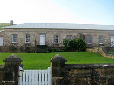
|
4
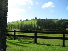
Looking north to the hills above Kingston
| 
5
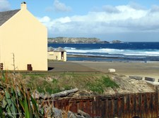
Commissariat Store in distance
The All Saints Church, formerly the Commissariat Store is the largest building in Kingston and was erected in 1835. Also used as a museum and storage for a vast amount of excavated material.
| 
6
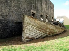
View across the wetlands
Flocks of Geese are often seen here.
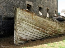
|

7
Circular Stone Well
| 
8
Longridge Road Information
| 
9
Flagstaff Hill Walk
Insufficient time to attempt this walk.
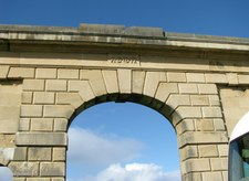
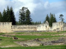
|

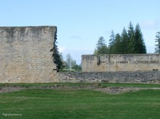
10
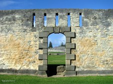
Memorial Seat on Flagstaff Hill Walk
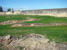
Syd "Guv" Christian 1927-1998.
| 
11
Historic Georgian Buildings of Kingston
From base of Flafstaff Hill Walk. In the early 1960's a program of conservation of the early buildings and ruins was commenced. The work is funded jointly by the Commonwealth and Norfolk Island governments, and is now administered by the Kingston and Arthur's Vale Historic Area Management Board, which comprises representatives of each government. The Kingston and Arthur's Vale Historic Area is on the Register of the National Estate and is of international heritage significance.
| 
12
Overlooking Kingston
The restored Georgian buildings are used in many ways; museums, administration and legislative purposes, church, dwelling houses, clubhouse and theatre. The outdoor areas have many public amenities.
|
13
Approaching Kingston Pier
Nepean Island on horizon.
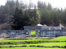
| 
14
Kingston Pier
In the early days of the Second Settlement, a landing place was established at a point beside the site of the present pier. Construction of Kingston Pier commenced in 1839 and was completed in 1847. It still functions today as the primary site for shipping, both overseas and local.
| 
15
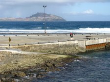
Kingston Pier
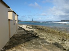
As Norfolk Island has no harbour, ships stand about a kilometre off shore and lighters are sent out to pick up passengers and cargo.
|

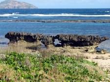
16
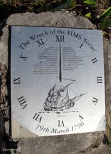
Coastline west of Kingston Pier
| 
17
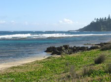
Coast east of the Kingston Pier
Flaghouse Buildings and Seawall.
| 
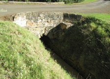
18
Phillip Island
Seven kilometres south of Norfolk, the uninhabited Phillip Island rises to a height of 274 metres. The island is about 2 kms long and nearly 2 kms wide. Twelve species of seabirds are listed as breeding on the island.
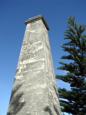
|

19
Phillip Island by 10 x zoom
Vegetation on Phillip Island became denuded by the Rabbits which were introduced by the early settlers. An eradication program began in the 1970's and resulted in the last rabbit being exterminated in 1988. Regeneration of native species has resulted in vegetation now flourishing in many places.
| 
20
The Crankmill
The Crankmill comprises the remains of the only known pre-1850 human-powered crankmill in Australia. It was built as a two-storey granary in 1827. A cranking mechanism, hopper and grindstones for grinding maize were installed in 1837. The equipment was worked as punishment by a hundred convicts in irons. After 1856 the building was gutted by fire.
| 
21
Old Lighter beside Crankmill Ruins
Similar scenes are featured on many postcards, but it was unfortunate that a car was allowed to park where it spoilt the picture.
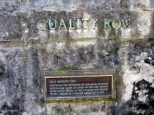
|
22
Closer view of Old Lighter
| 
23
Single Boatshed and Flaghouses
| 
24
Flaghouse Information
|

25
Interior of Flaghouse
The Flaghouse was built in the early 1840's to store the settlement's collection of multi-coloured flags. The ships were signalled by colour coded flags until the 1950's.
| 
26
Double Boatshed and Lighter
The Double Boatshed provides a rare example of a building of its type and age. It was built in 1841 as a temorary shed on the site of an old barn and accommodated two 8 to 14 ton launches and two 6-oared whaleboats.
| 
27
Pier Store built 1825
Now houses Norfolk Island Museum. Displays include the artefacts from the flagship of the First Fleet, HMS Sirius, shipwrecked off Kingston in 1790; a cannon and copper kettle from HMS Bounty; also artefacts brought from Pitcairn Island in 1856.
|

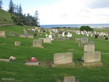
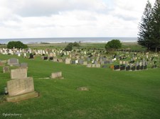
28
Restored Buildings of Kingston
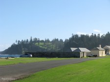
| 
29
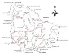
Near Crankmill Ruins
| 
30
Royal Engineer's Office built 1851
Located near Kingston Pier, this building contains a cafe, books, postcards, etc. relevant to the history of the Island.
|

31
The Overseer's Quarters
| 
32
Arched entrance of New Gaol
Building commenced in 1836 but the main block was not completed until 1847 because of conflicting opinions over the design.
| 
33
Wall of New Gaol
|

34
Entrance to New Gaol
Constructed on a radial plan, it contained 84 cells, two lock up rooms, 10 turnkeys' rooms and 10 yards. The prisoners worked in chains on the roads or at the quarries.
| 
35
Inside the Walls
Remaining foundations of the cells. Over the years, internal walls have been removed to provide stone for other building purposes on the Island.
| 
36
From the Inside looking Out
|

37
Double Row of Cells was here
| 
38
Information Plaque
| 
39
Sewer Drain flushed by the Tidal Flow
|

40
Remains of Isolation Cells
| 
41
Remains of Cells constructed in Radial Design
| 
42
Stone Toilet Seat
|

43
Toilet Hole in Cell Corner
Sewer Drains were flushed by rising tide.
| 
44
Front of Toilet Seat with Indentations for Leg Irons
| 
45
Remains of New Gaol Wall
Wall of Prisoners' Barracks in background.
|
46
View across New Gaol to far wall
After the transfer of prisoners to Tasmania, the cell walls were demolished and the stone used for other building works on the Island, consequently only the outline of foundations remain.
| 
47
The waters of Slaughter Bay and Nepean Island
From southern side of New Gaol.
| 
48
Prisoners' Barracks
Designed as a two-storeyed central barracks block and when completed it included Chapels, overseers' rooms, watch houses, guard posts, offices, stores, workshops and a court or school room, all surrounded by a 5 m high wall.
|
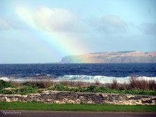
49
Rainbow over Nepean Island
| 
50
Remaining Wall of Prisoners' Barracks
| 
51
View between Stone Walls
|

52
Outside Prisoners' Barracks
| 
53
Protestant Capel through Prisoners' Barracks Arch
The Protestant Chapel continued in use for some time before becoming abandoned. It now houses the Museum Theatre.
| 
54
Eastern coast of Slaughter Bay
|
55
View along Bay Street
| 
56
Across the Bay to Phillip Island
| 
57
Limestone Formations along Slaughter Bay
|
58
Slaughter Bay (formerly Sydney Bay)
HMS Sirius was wrecked here on 19 March 1790.
| 
59
The Wreck of the HMS Sirius
On 19 March 1990 at 12.00 noon, this plaque was laid to commemorate the bicentenary of the wrecking of HMS Sirius on the reef in Sydney Bay, Norfolk Island.
| 
60
Wall of Prisoners' Barracks from Bay Street
|

61
The Sands of Emily Bay
Formerly known as Sandy Bay or Turtle Bay, this crescent of golden sand backed by beach grass and pines has been known as Emily Bay since the late 1830's.
| 
62
Emily Bay
Visitors explore the marine life of Emily Bay from the glass-bottom boat.
| 
63
Emily Bay
Note the Salthouse behind the Norfolk Island Pines.
|
64
Convict-built stone drain passes under the road
| 
65
Another view of Emily Bay
| 
66
Drain empties into Emily Bay
|

67
Approaching the Salt House
| 
68
Chimney of the Salthouse
| 
69
The second Salthouse
The first Salthouse was near the pier end of Bay Street. This second Salthouse is still standing on the western edge of Emily Bay.
|

70
Lime Kiln built 1845
The Lime produced here was of a very hight quality.
| 
71
Lime Kiln information
| 
72
Bricked remains of old Lime Kiln
Remains of first penal settlement Lime Kiln built in 1792 or 1803.
|

73
Sandy Beach near Lime Kilns
| 
74
Old Military Barracks viewed from Bay Street
| 
75
Government House Reserve
|

76
All aboard to visit Quality Row
| 
77
Officers' Bath on Quality Row
Close to the Military Barracks is a structure traditionally known as the Officers' Bath. The grassed area at the rear was used as a parade ground.
| 
78
Officers' Bath (through the window)
Sixteen stone steps lead down into a rectangular enclosure containing a low trough or bath hewn from limestone. The trough is fed by a good stream running through a curved duct lined with limestone blocks. The stream runs under Quality Row to the sea.
|

79
View along Quality Row
A short straight road containing a large group of convict-built structures in good repair, some in use as Administration offices and others are occupied as residences. All these buildings date from the Second Settlement and many of them were occupied by Pitcairners and their descendants from 1856 until 1908.
| 
80
No 9 Quality Row
Originally the residence of the Royal Engineer Officer and later occupied by the Rev. George Hunn Nobbs, Pastor of the Pitcairn Settlement in 1856. Rebuilt as a private residence in 1968.
| 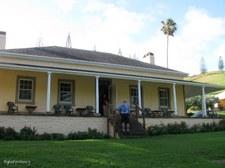
81
No 9 Quality Row
The occupiers kindly allowed us to walk through this historic home.
|

82
View from the front steps
| 
83
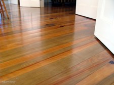
Beautiful Polished Floorboards
Extensive use is made of Norfolk Pine in Island homes.
| 
84
Rear Entrance of House
|
85
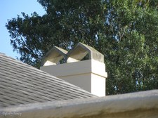
The Chimney Tops
| 
86
Tall Chimney
| 
87
Another external view of the Restoration
|

88
Fireplace awaiting restoration
This is a separate building at the rear of the house.
| 
89
Candles by the window
| 
90
Display of Kerosene Lamps
|

91
Awaiting restoration
| 
92
The Porous Stone makes neat Paving
| 
93
Circular Well in Courtyard
|

94
Young Norfolk Pines on Hill
Rear corner of back yard.
| 
95
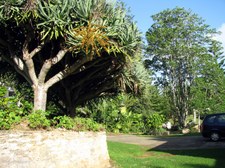
Pandanus Palm above Stone Wall
| 
96
Sprays of Seeds on Pandanus Palm
|

97
Burnt Ruins of No 4 Quality Row
| 
98
Duplex No 2-3 Quality Row
This is No 3 Quality Row.
| 
99
Duplex No 2-3 Quality Row
This is No 2 Quality Row.
|

100
Cattle Grid at entrance to property
| 
101
Kingston Cemetery
The site of this present cemetery was set aside for burials soon after the 1825 occupation.
| 
102
Kingston Cemetery
The next album will contain a more detailed view of this Historic Cemetery.
|

103
Golf Links
The golf links occupy land bounded by Quality Row, Government House, a reserve and the coastline. During the Second Settlement, this land was partly occupied by the soldiers' gardens and the garrison farm.
| 
104
The lush green of the Golf Course
| 
105
Norfolk Island Map
This map has been included to help viewers find the places that I have mentioned in my albums.
|

106
Emily Bay
Two photo panorama of Emily Bay.
| 
107
Emily Bay Panorama
Three photo panorama of Emily Bay.
| |
