
1
Gairdner River looking Downstream
The Gairdner River flows through the pristine Fitzgerald River National Park to the Southern Ocean.
| 
2
Gairdner River looking Upstream
The Gairdner River is popular for Canoeing and provides a pleasant flatwater paddle.
| 
3
Gairdner River
Upstream View of the Gairdner River.
|

4
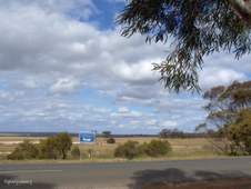
Gairdner River
Downstream View of the Gairdner River.
| 
5
River Bank
On the Bank of the Gairdner River.
| 
6
Parting view of the Gairdner River
Upstream view of the Gairdner River.
|

7
Four-Winged Mallee
Young Four-Winged Mallee (Eucalyptus tetraptera).
| 
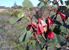
8
Four-Winged Mallee Flower
The opening Flower of the Eucalyptus tetraptera.
| 
9
Flowers Four-Winged Mallee
Flower Buds of the Eucalyptus tetraptera.
|
10
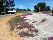
Grevillea nudiflora
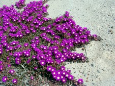
One of many species of Grevillea.
| 
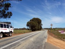
11
Toothbrush Grevillea
Unusual Grevillea with Toothbrush-shaped Flower.
| 
12
Toothbrush Grevillea
Side view showing Toothbrush-shape of flower.
|

13
Far Horizons
View across Southern Mallee Shrublands towards farming land of Jerramungup.
| 
14
Posy Starflower (Calytrix leschenaultii)
| 
15
Pink Myrtle
|

16
Vegetation beside the Road
Southern Mallee Shrublands.
| 
17
Fitzgerald Biosphere
A Biosphere reserve is an area dedicated to exploring how people and nature can flourish together.
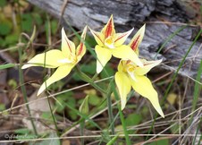
| 
18
Caterpillar Tractor
This Caperpillar Tractor now rests at Jerramungup after being used to clear the land for farming.
|

19
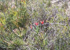
Clawflower
Colourful Clawflower at Jerramungup.
| 
20
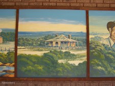
Jerramungup Story 1
Mural depicting the History of Jerramungup. The first inhabitants were the Aborigines.
| 
21
Jerramungup Story 2
Early Explorers Sailed around the Coastline.
|

22
Jerramungup Story 3
Following exploration by John Septimus Roe, graziers arrived with flocks of Sheep.
| 
23
Jerramungup Story 4
Further exploration took place in the Gairdner River area.
| 
24
Jerramungup Story 5
The Hassell Homestead was built of stone in 1859 by the Hassell Family.
|
25
Jerramungup Story 6
The second Hassell Homestead was built in the late 1800's, about 6km from where the town of Jerramungup now stands.
| 
26
Jerramungup Story 7
In 1953 under the War Service Land Settlement Scheme, 133 farms were created and ex-servicemen who had completed war service became soldier settlers.
| 
27
Jerramungup Story 8
The unique and Internationally recognised Fitzgerald River National Park represents 48% of the Biosphere.
|

28
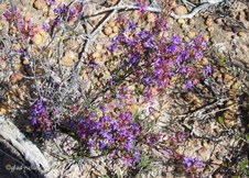
Colourful Pea Flowers
Flowering brightly in Jerramungup.
| 
29
Flower Buds of Yate
Long-fingered flower buds of this Jerramungup Eucalypt.
| 
30
Buds and Seed Cones
Long-fingered flower bud and spikey seed cones of Jerramungup Yate.
|

31
Jerramungup Farmlands
Explorer John Septimus Roe first used the name Jerramungup to refer to the area.
| 
32
Zoomed to Farmlands
The Wheat and Sheep Farming Shire of Jerramungup is located 429km SE of Perth.
| 
33
Jerramungup Road
|
34
Rural View at Jerramungup
| 
35
Tall Trees at Jerramungup
| 
36
Can you find the Bird?
The Bird was a bonus when I zoomed up to photograph these flowers.
|
37
Roadside Colour
Roadside Colour while travelling between Jerramungup and Dumbleyung with www.wanderer.com.au
| 
38
Round-leaved Pig Face
(Disphyma crassifolium).
| 
39
Colour Contrast
(Disphyma crassifolium).
|

40
The Road Behind
The road from Jerramungup.
| 
41
Bitumen Road Ahead
The road to Dumbleyung.
| 
42
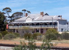
Dumbleyung Hotel
Dumbleyung is a small wheatbelt town 275km SE Perth. The Dumbleyung Hotel was built in 1913.
|

43
Pioneer Wagon
An old wagon used by early settlers.
| 
44
Scrub Roller
Scrub Roller as used by early settlers to clear the land for farming.
| 
45
Dumbleyung Roadhouse
|

46
Dumbleyung Hotel framed by Trees
| 
47
Dumbleyung Hotel
Viewed from another angle, Dumbleyung Hotel, built 1913.
| 
48
Main Street Gardens
Dumbleyung Street scene. The Shire covers an area of 2551 sq km and has a population of 701 (2002 statistics).
|

49
Railway Line and Goods Shed
The Railway Line runs through the town of Dumbleyung.
| 
50
Lake Dumbleyung
The first recorded sighting of Lake Dumbleyung was in 1843 by explorers Landor and Lefroy.
| 
51
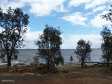
Approaching Lake Dumbleyung
Lake Dumbleyung is the largest open lake in Western Australia's southwest at 13km in length and 6.5km wide, covering an area of 5200 hectares.
|

52
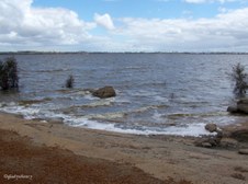
Lake Beyond Trees
Lake Dumbleyung received world recognition when Donald Campbell broke the world water speed record here on 31 Dec 1964.
| 
53
Stormy Skies
Donald Campbell travelled at 276.3 miles per hour (442.08 km) in his boat named Bluebird to break the world water speed record on Lake Dumbleyung.
| 
54
Sun and Cloud
Sun and Cloud over Lake Dumbleyung.
|

55
Boat Ramp
Boat Ramp used for water skiing on Lake Dumbleyung.
| 
56
Water Expanse
Lake Dumbleyung.
| 
57
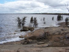
Wind making Waves
A strong icy wind making waves on Lake Dumbleyung.
|
58
Foam on Edges
Wind blowing foam on edges of Lake Dumbleyung.
| 
59
Waves on Lake
Waves on Lake Dumbleyung and one Rainspot on my Lens.
| 
60
Edge of Lake
Edge of Lake Dumbleyung and more rainspots on my Lens.
|

61
The Giant Ram at Wagin
The Giant Ram was built in Wagin and put in place in 1985. The annual Wagin Woolorama is one of the State's largest Agricultural Shows and attracts over 30,000 visitors.
| 
62
Near Williams
Bushland scene in the Williams area.
| 
63
Lichen on Rock
Lichen on a Rock in the Williams area.
|

64
Green Spider Orchids (Caladenia)
| 
65
Yellow Cowslip Orchids (Caladenia flava)
| 
66
Green Spider Orchids (Caladenia)
|

67
Bushland Scene
Bushland Scene taken near Williams.
| 
68
Buttercups and Triggerplants
Taken in Bushland at Crossman.
| 
69
Pea Flower
Colourful Pea Flower at Crossman.
|

70
Bushland near Crossman
| 
71
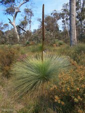
Grasstree and Flora at Crossman
| 
72
Grasstree Flower Spike
Close-up of Grasstree Flower Spike.
|

73
Silvery Cottonheads (Conostylis pusilla)
| 
74
Common Velleia (Velleia trinervis)
| 
75
Pink Tetratheca at Crossman
|

76
Thankyou for Viewing
The End of an enjoyable 4-day Southern Wildflower Tour -- www.wanderer.com.au
| |
