1
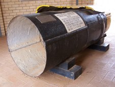
Damaged Water Pipe
First stop at Meckering where this 30 inch Water Pipe was damaged in the 1968 Earthquake.
| 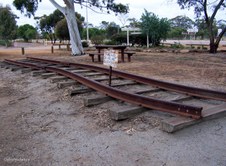
2
Buckled Railway Line
A section of Standard Gauge Line which was damaged in the Earthquake.
| 
3
Meckering Earthquake Damage
|
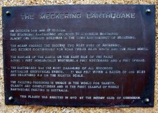
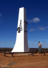
4
Meckering Earthquake
On 14 Oct 1968 at 10.59am the strongest Earthquake recorded in Australia destroyed almost 100 buildings in the town and district of Meckering. It was felt in a radius of 450 miles and registered 6.9 on the Richter Scale.
| 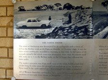
5
Meckering Earthquake
The Earth Shook and left a Fault Line 32km long. In some areas the ground was pushed up 1.5m and in other areas a deep crack opened up.
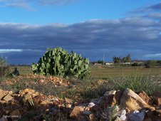
| 
6
Meckering Earthquake
Many of the town's services were cut including Road and Rail connections, and Power, Telephone and Water Supplies.
|

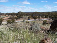
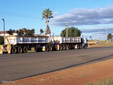
7
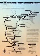
Goldfields Pipeline
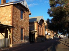
Pipeline Display on Lookout Hill, Southern Cross. Water is piped from Mundaring near Perth to the Goldfields through 557km of Steel Pipeline.
| 
8
Centenary of Southern Cross
Commemorating the Australian Bicentenary 1788-1988 and Southern Cross Centenary 1888-1988.
| 
9
Goldfields Pipeline
The town of Southern Cross framed by Pipeline.
|

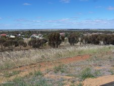
10
Southern Cross 1
View of town from Lookout Hill.
| 
11
Southern Cross 2
The first major Gold Discovery of the Eastern Goldfields District was made here in 1888.
| 
12
Southern Cross 3
Southern Cross now has a mixture of Gold Mining and Wheat Farming.
|

13
Southern Cross 4
Southern Cross is located 357 m above sea level, and is 368 km east of Perth on Great Eastern Highway.
| 
14
Southern Cross 5
Goldfields Pipeline running parallel with Great Eastern Highway.
| 
15
Southern Cross 6
Risely and Toomey claimed they had been led to their discovery of Gold by the Southern Cross and they named the goldfield after the constellation.
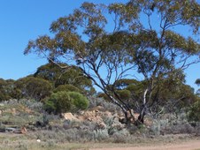
|

16
Southern Cross 7
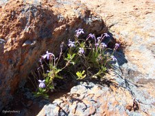
Today the area produces oats, barley, wheat, sheep and gold but the average annual rainfall of 279 mm means that the land is marginal.
| 
17
Southern Cross 8
In recent times the fluctuating price of gold has seen renewed interest in the Southern Cross area with both Broken Hill Metals NL and Golden Valley Mines NL being the main operators in the region.
| 
18
Salmon Gums at Coolgardie
Late afternoon light on these majestic Salmon Gums (Eucalyptus salmonophloia) at Coolgardie.
|

19
Grave of Ernest Giles
The Grave of early Explorer Ernest Giles in Pioneer Cemetery, Coolgardie.
| 
20
Plaque Ernest Giles
Respected Explorer Ernest Giles, 1835-1897.
| 
21
Main Street of Coolgardie
Late afternoon on the main street of Coolgardie which is 558 km east of Perth.
|
22
Dramatic Sky
Dramatic Sky over now vacant land and rubble from prior buildings at Coolgardie.
| 
23
Heavy Haulage
These wide streets were made for Camel Trains which have now been replaced by Heavy Haulage Trucks.
| 
24
Road Train
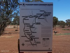
Road Train under Dramatic Coolgardie Sky.
|

25
Historic Coolgardie Buildings
Two of Coolgardie's Historic Buildings.
| 
26
Restored Coolgardie House
This Coolgardie House is beautifully maintained.
| 
27
Verandah and Rain Water Tank
There is a Rain Water Tank at the end of the Verandah.
|

28
Coolgardie General Store
| 
29
Window Display
The Window Display in an old Shop at Coolgardie.
| 
30
Abandoned House
Derelict House at Coolgardie.
|
31
Historic Old Goal
Golden Rays of the evening Sun on the Historic Old Goal at Coolgardie.
| 
32
Golden Sun Rays
Golden Rays of the Setting Sun on the Historic Buildings of Coolgardie.
| 
33
Warden's Court Building
Historic Warden's Court Building which is now used as a Visitor's Centre.
|

34
Historic Warden's Court
Historic Warden's Court Building at Coolgardie.
| 
35
Typical House in Fading Light
Typical Houses in Coolgardie were built of Corrugated Iron.
| 
36
Coolgardie Museum 1
Display at Ben Prior's open air Museum, Coolgardie.
|

37
Coolgardie Museum 2
Display at Ben Prior's open air Museum, Coolgardie.
| 
38
Coolgardie Museum 3
Display at Ben Prior's open air Museum, Coolgardie.
| 
39
Coolgardie Museum 4
Display at Ben Prior's open air Museum, Coolgardie.
|

40
Coolgardie Museum 5
Display at Ben Prior's open air Museum, Coolgardie.
| 
41
Pelargoniums on Fence
Colourful Pelargoniums greet a new Day in Coolgardie.
| 
42
Beautiful Homestead
Beautiful Australian Homestead in the morning Sun at Coolgardie.
|

43
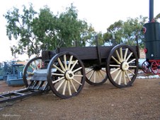
Garden Feature
Old Wagon at rest in Homestead Garden at Coolgardie.
| 
44
Coolgardie Houses
Coolgardie Houses with Goldfields Pipeline in foreground.
| 
45
Coolgardie Post Office
Coolgardie Post Office, note Historic Telephone Box and Letter Box.
|

46
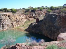
Coolgardie Swimming Hole
A popular spot on a hot day.
| 
47
055 Coolgardie Swimming Hole
| 
48
Coolgardie Swimming Hole
Temperatures range from -3C on cold frosty nights to 45C on hot sunny days.
|

49
Drilling for Samples
Drilling Rig taking Samples at Coolgardie.
| 
50
Mallee Scrubland
Bonnie Vale area north of Coolgardie.
| 
51
Mallee Scrubland
Bonnie Vale was Gazetted as a Goldmining Townsite in 1897, but has now returned to nature.
|

52
Pink Eremophila
| 
53
Silver Saltbush
| 
54
Mauve Eremophila
|

55
Salt Bush
The Silver-Grey Saltbush contrasts with the Red Soil.
| 
56
Eucalyptus Trees and Saltbush
| 
57
Red Eremophila
|

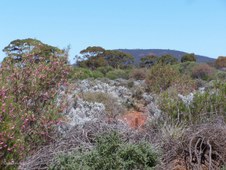
58
Goldfields Woodlands
Nowhere else in the world are there so many different Tall Trees in a similar arid climate where annual Rainfall is 150 - 300mm.
| 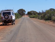
59
The Road Ahead
The End of the Bitumen north of Coolgardie.
| 
60
Mt Burges
Mt Burges at 553 m is the highest point in the area and surrounded by attractive bush.
|

61
Flannel Bush
| 
62
Cassia
| 
63
Cotton Bush (Ptilotus obovatus)
|

64
Pea Flowered Shrub
| 
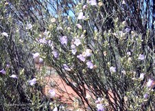
65
Pink Velleia (Velleia rosea)
| 
66
Growing on the Rocks
|

67
Kunanalling Rock
A large Granite Rock near the townsite of Kunanalling.
| 
68
Kunanalling Rock
| 
69
Kunanalling Rock
Note the Stone Wall built to divert run-off Water into a storage Dam.
|

70
Kunanalling Rock
Vegetation surrounding Kunanalling Rock.
| 
71
Kunanalling Rock
| 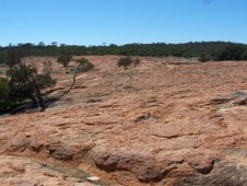
72
Kunanalling Rock
A large expanse of Granite.
|

73
Base of Kunanalling Rock
| 
74
Pink Velleia (Velleia rosea)
| 
75
Kunanalling Rock
|

76
Kunanalling Townsite
The townsite of Kunanalling is located in the eastern goldfields, 25 Miles from Coolgardie . Gold was discovered here in 1895, and it was originally known as the 25 Mile.
| 
77
Kunanalling Town Site
Latitude : 30 41 S Longitude 121 04 E. The Ghost Town of Kunanalling was Gazetted as a Townsite in 1896.
| 
78
Kunanalling Hotel
Stone Walls are now all that remain of the Premier Hotel.
|
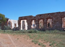
79
094 Hotel Ruins
Premier Hotel, Kunanalling.
| 
80
Lobed-Leaf Hop-Bush (Dodonaea lobulata)
| 
81
Kunanalling Hotel
Stone Walls of the Premier Hotel, Kunanalling.
|

82
Cotton Bush (Ptilotus obovatus)
| 
83
Premier Hotel Kunanalling
Framed by natural vegetation.
| 
84
Eucalyptus Trees and Saltbush
Taken between Kunanalling and Ora Banda.
|

85
Saltbush and Trees
| 
86
Salmon Gum
Eucalyptus salmonophloia is a West Australian Tree that grows to 25m with beautiful smooth waxy salmon pink bark.
| 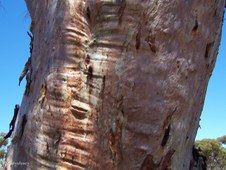
87
Trunk of Salmon Gum
The smooth waxy salmon pink bark of the Eucalyptus salmonophloia.
|

88
Bobtail Lizard
This one was basking in the Sun on the edge of the road.
| 
89
Bobtail Lizard
Not happy at being disturbed!
| 
90
Bobtail Lizard
Open Wide!! See my Blue Tongue!!
|

91
Salmon Gums and Gimlet
| 
92
Ora Banda
In 1906 rich ore bodies were found about 3km south of Ora Banda and by 1910 there were approximately 2,000 miners and their families living in the area.
| 
93
Welcome to Ora Banda
Ora Banda is located 66km north-east of Perth. The name Ora Banda is Spanish meaning Band of Gold.
|
94
Ora Banda Map
Location of Ora Banda in relation to other Goldfields Towns.
| 
95
Ora Banda History
Ora Banda maintained its mining importance and in 1911 the Ora Banda Hotel was constructed by Alfred E Garnett using stone and brick, and for 40 years it traded successfully surviving fires and extensive hailstone damage until the inevitable happened. By the late 1950s mining at Ora Banda was no longer financially viable and the hotel and the last remaining shop closed.
| 
96
Ora Banda Hotel and Store
Vandalism and time took its toll and the hotel was reduced to a shell until it was restored and re-opened in 1981 under a tavern licence.
|
97
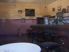
Deserted Bar
View of the Deserted Bar taken through the window.
| 
98
Pub with No Beer
In 1995 the hotel was purchased by the family of former WA detective Don Hancock and it once again became a popular meeting place for locals and visitors. In October, 2000, the hotel and several other buildings in the township were bombed. The badly damaged hotel building was later purchased and restored again and re-opened for public trade in October, 2002. It is now Closed and For Sale once again.
| 
99
Old Truck
Old Truck at rest behind the Ora Banda Hotel.
|
100
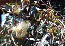
Flowering Gum
Flowering Gum (Eucalyptus) behind the Ora Banda Hotel.
| |
