
1
Bremer Bay Mural 1
Salmon (Western Australian): Catch your own from the large schools that inhabit our waters between February-May.
| 
2
Bremer Bay Mural 2
Southern Right Whale: Can be seen frolicking in our waters between July-September.
| 
3
Bremer Bay Mural 3
Leafy Sea Dragon: See one for yourself along the dive trail situated at Little Boat Harbour.
|

4
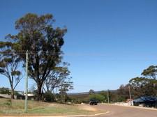
Bremer Bay
Bremer Bay was named in 1848 by Surveyor General John Septimus Roe. This popular holiday and fishing resort has a permanent population of 300 and is situated near the Fitzgerald National Park.
| 
5
Pristine Waters of Bremer Bay
| 
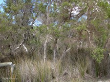
6
Coastal Vegetation
|

7
Eucalypt species in flower
| 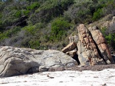
8
Rock Formations
| 
9
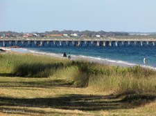
Bremer Bay Town Beach
The azure blue water and endless white sand make the Town Beach popular for swimming, or fishing from the rocks.
|

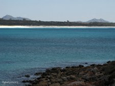
10
Zoomed across Bremer Bay
Mt Maxwell (184m) and West Mt Barren (340m) on the horizon.
| 
11
Clouds moving over Bremer Bay
| 
12
View across the Bay
|

13
Seaweed left by the Tide
| 
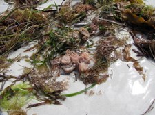
14
Remains of a Shell
| 
15
White Sand and Rock Formations
|
16
White Sands of James Cove
| 
17
Walking towards the Sandbar at mouth of Bremer River
| 
18
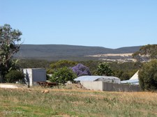
Left by the receding Tide
|

19
Life on the White Sand
| 
20
Sand Dune Re-vegetation
| 
21
Dune Cabbage introduced from Africa
Dune Cabbage (Arctotheca populifolia), prostrate perennial with thick silver hairy stems and leaves. Introduced from Africa, grows only on coastal dunes, used as a stabilizing plant.
|

22
The Sandbar at mouth of Bremer River
| 
23
Off Road Vehicle Prohibition Area
| 
24
Wind Turbine generates Power
|

25
Black-winged Stilts in the shallows of Wellstead Estuary
| 
26
Paperbark Trees and Sedges in the Wetlands
| 
27
Recreational Areas
|

28
Last view of Bremer Bay beyond the Sandbar
| 
29
Peppermint Trees beside the Road
Agonis flexuosa grows to 15m and occurs on coastal sands and limestone heaths.
| 
30
At the end of Cuneo Drive, Bremer Bay
|

31
James Cove across the Bay
| 
32
Mt Maxwell & West Mt Barren above James Cove
Viewed from Lookout at end of Cuneo Drive.
| 
33
View across the Bay towards Peppermint Beach area
|

34
Blue Waters of Bremer Bay
| 
35
Rock Cairn
The original rock cairn on this site was built by the early Wellstead family under Government maritime supervision as a means of alerting visiting coastal ships when there were travellers or cargo to go aboard. By means of a white day flag or a lantern at the head of the central pole the crew would know that there could be, for example, wool, tree bark or produce to be picked up for one or other of the ports around the south coast which they visited regularly.
| 
36
Plaque on Rock Cairn
The service was phased out in the early 1930s when shipping ceased and road transport took over. With the passing years the cairn collapsed and suffered from vandalism. In the 1980s the local Progress Assoication, together with the then active Tourism Committee, decided to reconstruct the cairn as something of historical interest, but it was built in a slightly different form from the original.
|

37
Windpower for the town
| 
38
Looking at the Southern Ocean
| 
39
Waves splash on the Rocks below
|

40
Rocky Island off-shore
| 
41
Fishery Beach Marina across the water
| 
42
White Sands of Back Beach
|

43
Fishery Beach
| 
44
Back Beach
Pristine White Sand and Azure Blue Water.
| 
45
Stunted Windswept Vegetation
|

46
Fishery Beach Marina
| 
47
Bremer Bay Boat Harbour
| 
48
Fishing Boats
|

49
Mt Maxwell and West Mt Barren from Boat Harbour
West Mt Barren is in the Fitzgerald National Park.
| 
50
Granite Rock Wall of Boat Harbour
White Sands of the Back Beach.
| 
51
Quarry provided Granite Rock for Harbour
|

52
Quarry now used as Parking for Harbour
| 
53
Arrived at Jerramungup for Picnic Lunch
Explorer John Septimus Roe first used the name Jerramungup to refer to the area.
| 
54
Jerramungup Road
The Wheat and Sheep Farming Shire of Jerramungup is located 429km SE of Perth.
|

55
Melaleuca species
| 
56
Natural Vegetation
| 
57
Barrens Clawflower
Calothamnus validus.
|

58
Fitzgerald Biosphere
A Biosphere reserve is an area dedicated to exploring how people and nature can flourish together.
| 
59
History of Jerramungup 1
Mural depicting the History of Jerramungup. The first inhabitants were the Aborigines. Early Explorers Sailed around the Coastline.
| 
60
History of Jerramungup 2
Following exploration by John Septimus Roe, graziers arrived with flocks of Sheep. Further exploration took place in the Gairdner River area.
|

61
History of Jerramungup 3
The Hassell Homestead was built of stone in 1859 by the Hassell Family. The second Hassell Homestead was built in the late 1800's, about 6km from where the town of Jerramungup now stands.
| 
62
History of Jerramungup 4
In 1953 under the War Service Land Settlement Scheme, 133 farms were created and ex-servicemen who had completed war service became soldier settlers.
| 
63
History of Jerramungup 5
The unique and Internationally recognised Fitzgerald River National Park represents 48% of the Biosphere.
|

64
Caterpillar Twenty Two Tractor
Used by early settlers for clearing the land.
| 
65
Jerramungup IGA
"Your Local One Stop Shop".
| 
66
Tobruk Traders
Newsagency, Cafe, Fuel.
|

67
Formerly Ravensthorpe Post Office
Now 'Australian Country Information Service' with offices of Centrelink, Community Development, Esperance Group Training, ATO, Medicare & Legal Aid.
| 
68
Ravensthorpe Police Station
Built in 1967.
| 
69
Palace Hotel
Built 1907.
|

70
F E Daw & Sons Grocery Store
Now Ravensthorpe IGA.
| 
71
Ravensthorpe Shire Council Office
Formerly Phillips River Road Board until 1961.
| 
72
Ravensthorpe Post Office
|

73
Granite Bottlebrush on Post Office Corner
Melaleuca elliptica (Granite Bottlebush) is a shrub which is endemic to the south of Western Australia. Its red flowers appear from September to January and it usually grows 1-4 metres in height occuring near granite rocks.
| 
74
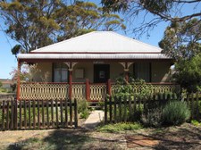
This used to be my Home
This house in Spence Street was our home from 1967 - 1974.
| 
75
Trees in the Valley below Spence St
|
76
Tall Trees of Spence St
| 
77
New Supermarket under Construction
| 
78
Ravensthorpe Ranges 1
Taken from half-way down the hill in Morgans Street.
|

79
Ravensthorpe Ranges 2
| 
80
Ravensthorpe Ranges 3
'Cellarbrations' is a new addition to town.
| 
81
Ravensthorpe Ranges 4
Morgans Street slopes down the hill.
|

82
Many Trucks pass through Town
| 
83
Ravensthorpe Chemist
| 
84
Eastern End of Morgans Street
|

85
Video Store
| 
86
Heritage House well-maintained
| 
87
Information Stop and Museum
|

88
Old Jail used 1900-1967 relocated to Museum
Looking through the fence at the Museum.
| 
89
Steam Engine at Museum
| 
90
Ravensthorpe-Hopetoun Railway Carriage
The Ravensthorpe-Hopetoun Railway operated from 1909-1935.
|

91
Shop for Lease
This used to be the Co-op where I did my shopping 35 years ago, it has since been a Post Office and is now 'For Lease'.
| 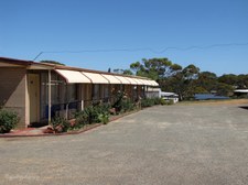
92
Motel Units beside Palace Hotel
| 
93
Senior Citizens Centre
The location of the Annual Wildflower Show.
|

94
Gardens at Senior Citizens Centre
| 
95
Shelter at Senior Citizens Centre
| 
96
Ravensthorpe Centenary Mural
In this 100th year of Federation, 2001 AD, we celebrate the centenary of Ravensthorpe Townsite gazetted 30th Jan 1901.
This mural is dedicated to all those who have contributed to the developement of the town and the district.
|

97
Ravensthorpe Nickel Mine
Hard to focus as we travelled past on the way to Esperance.
| 
98
Ravensthorpe Nickel Mine
Zoomed in as we drove past.
| 
99
The Road to Esperance
Turn-off to Ravensthorpe Nickel Mine which was closed in January 2009 and sold in December 2009.
|
100
Esperance Jetty
Esperance lies along the southern coast of Western Australia, 721km from Perth. Esperance Bay was named by French navigator Rear Admiral D'Entrecasteaux in 1792 as his two ships sheltered there during a storm. Settlement did not occur until 1864 and the townsite was surveyed in 1881.
| 
101
Esperance Bay and off-shore Islands
The Shire of Esperance has an area of 43,000 sq km, and includes over 400km of coastline, which ranges from gently undulating bays and picturesque islands of the Recherche Archipelago , to the spectacular cliffs of the Great Australian Bight.
| 
102
Esperance, Bay of Isles
The Archipelago of the Recherche, or the Bay of Isles can be seen from vantage points around Esperance. There are over 100 islands covering 4000 square kilometres, all of which are A-class nature reserves.
|

103
White Sands of Esperance Foreshore
| 
104
Tall Grass on the Dunes
| 
105
Dogs have restricted off-leash use of the Beach
I hope all dogs can tell the time!
|

106
Walking along the Groyne
| 
107
Esperance Port
With the completion of a $54 million port upgrade project in February 2002, Esperance became the deepest port in southern Australia, capable of handling Cape Class vessels up to 200,000 tonnes, plus fully loaded Panamax class vessels up to 75,000 tonnes. As a result of this development, iron ore exports through the Port are expected to total 8 million tonnes per year by 2010.
| 
108
Busy Esperance Port
The Port is also a major grain exporting hub and handles bulk imports such as fuel and fertilisers. Esperance Port is expected to handle 230 ships and more than 10.7 million tonnes total throughput of trade in 2009-10.
|

109
Late afternoon on Esperance Bay
Early settlers planted many Norfolk Island Pines which now line the foreshore.
| 
110
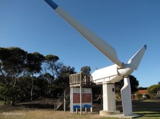
Monument to Salmon Beach Wind Farm
Australia's first wind farm, the Salmon Beach Wind Farm was built in Esperance in 1987. This 60kW wind turbine was one of two donated to the Esperance community from the Salmon Beach Wind Farm when it was decommissioned after operating for fifteen years.
| 
111
Information Plaque
The other wind turbine remains on the old wind farm site as a monument to this unique project. The wind turbines operating in Esperance today form two wind farms which are owned and operated by Verve Energy.
|

112
On the Wind Turbine Tower
View to the left.
| 
113
On the Wind Turbine Tower
View to the right.
| 
114
Steam Roller at Esperance Museum
|
115
First Esperance State School 1896
Currently the Esperance RSL Sub Branch Clubrooms.
| 
116
Wait here for the Mail to arrive
Circular Seat around tree near Post Office.
| 
117
One of the Plaques on Post Office Seat
Plaques record memories of those who waited for the mail to arrive.
|
