
1
Mundaring Community Sculpture Park
Located on the site of the former Mundaring Railway Station, artistic sculptures are set in bushland amidst nature's own masterpieces of Golden Wattles, Eucalypts and Wildflowers.
| 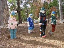
2
The Tourists
The Tourists are bronze figures painted in loud, colourful design reminiscent of the 1950s and 60s.
| 
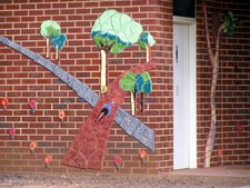
3
Mainstream
This sculpture is a reference to the Golden Pipeline that runs from Mundaring to Kalgoorlie. Constructed from sections of pipe, with all sorts of tools welded to the main body.
|

4
Another view of Mainstream
This sculpture is a reference to the Golden Pipeline that runs from Mundaring to Kalgoorlie. Constructed from sections of pipe, with all sorts of tools welded to the main body.
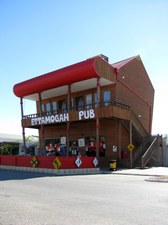
| 
5
Mother
A stylized figure's head, neck, shoulder and arm present a nurturing gesture and embrace a comfortable resting place.
| 
6
Missed the Last Train
A park bench project that cites history as a station and railway line.
|

7
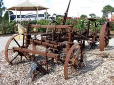
Missed the Last Train
Maybe, off to join the circus!
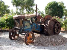
| 
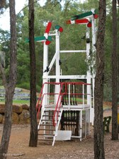
8
Moondae-ring Acoustic Sculpture
This sculpture is a enigmatic coming together of two artistic facets, the visual and the acoustic. In two sections, 'The Hub' (totem-pole structure) and 'The Sentenial' (the rocking horse structure) it hints at all manner of historic significance. The Moondae-Ring rises up out of old railway ground. Steam trains once hissed and hauled only metres from where the sculpture now replays the sound of a 'W' Class locomotive whistle.
| 
9
The Second Wave
Second Wave was constructed from the original railway signals and designed for the old Mundaring Station site - now the amphitheatre. The work is a doorway to the amphitheatre and uses exaggerated artificial perspective to create a funnelling effect as the amphitheatre is approached.
|

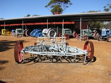
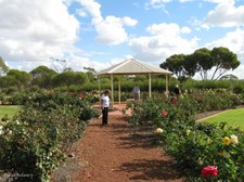
10
Untitled
This is a unique interpretation of a sculpture that functions as a seat. Inspiration has been drawn from found pieces of machinery that refer to the heritage of Mundaring.
| 
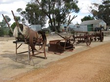
11
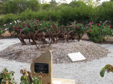
The Gate House
Presented to the residents of the Shire of Mundaring at the conclusion of the 2003 Centenary Year commemorating 100 years of local government in the Shire of Mundaring.
| 
12
Country Women's Association Hall
Colourful murals on the walls.
|
13
Mural on Toilet Walls
| 
14
Sign Post
Main Street of Cunderdin.
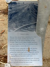
| 
15
Ettamogah Pub at Cunderdin
|
16
Water Tank at Ettamogah Pub
Cunderdin.
| 
17
Ettamogah Pub Sign
| 
18
Ettamogah Pub
Cunderdin.
|
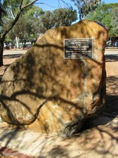
19
Commemorating the Centenary of Cunderdin
This plaque commemorates The Centenary of the Cunderdin Townsite declared 18th May 1906 under the Land Act (Govt. gazette) R. Cecil Clifton Under Secretary for Lands. The Cunderdin Historical Society 2006.
| 
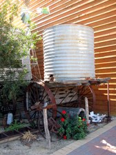
20
Railway Water Tower
Government Railways of W.A. - Water Tower - erected circa 1892.
Water gravitated from the rock catchment and reservoir (Cunderdin Hill) into this water tank to supply the railway steam engines.
| 
21
Railway Water Tower at Cunderdin
Government Railways of W.A. - Water Tower - erected circa 1892.
Water gravitated from the rock catchment and reservoir (Cunderdin Hill) into this water tank to supply the railway steam engines.
|
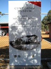
22
Cunderdin Museum
The museum building, formerly the No3 Pump Station on the Golden Pipeline, features the town icon, the brick chimney.
| 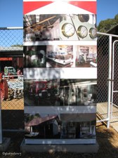
23
Cunderdin Museum
The collection includes the Worthington engine that powered the No7 Pump Station, a crop-dusting plane, a railway dining car, a tractor and truck display and the re-sited Qualegeting one-teacher school.
| 
24
Cunderdin Museum
Iconic brick chimney.
|
25
Cunderdin Museum
Display of tractors and agricultural machinery.
| 
26
Cunderdin Museum
Display of tractors and agricultural machinery.
| 
27
Cunderdin Museum
Caterpillar Thirty Tractor.
|

28
Cunderdin Museum
Deutz Tractor.
| 
29
Cunderdin Museum
Formerly the No 3 Pump Station on the Mundaring / Kalgoorlie water pipeline.
| 
30
Cunderdin Museum
Formerly No 3 Pump Station.
|

31
Cunderdin Museum
The iconic chimney of the former No 3 Pump Station.
| 
32
Cunderdin Museum
Rural Lifestyle Pavillion.
| 
33
Cunderdin Museum
Displays include agricultural machinery used in bygone years, an original steam pump used on the Goldfields Water Scheme, a Tigermoth aircraft, an original bush school and many artifacts depicting the pioneering spirit of the district.
|

34
Cunderdin Museum
View through the fence.
| 
35
Cunderdin Museum
Viewed from the Ettamogah Pub.
| 
36
Memorial Rose Garden, Meckering Townsite
Officially opened October 2008 to commemorate the 40th Anniversary of the 1968 Meckering Earthquake.
|
37
Meckering Memorial Rose Garden
| 
38
Mouldboard Plough
Meckering Memorial Rose Garden.
| 
39
Meckering Memorial Rose Garden
|
40
Fordson Tractor
Meckering Memorial Rose Garden.
| 
41
Machinery Display
Meckering Memorial Rose Garden.
| 
42
Ingenious Cement Mixer
Meckering Memorial Rose Garden.
|

43
Earthquake Memorial
Meckering Memorial Rose Garden.
| 
44
Earthquake Memorial
This depicts the scene that most faced with all the shops and the majority of houses ruined.
| 
45
Earthquake Memorial
On 14th October 1968 an earthquake measuring 6.9 rocked Meckering. Many houses were destroyed and the town relocated to its present site. This depicts the scene that most faced with all the shops and the majority of houses ruined.
|

46
Earthquake Facts
Date: 14th October 1968
Time: 10.59 a.m.
Intensity: Approx 6.9 on Richter Scale
Epicentre: Latitude 30.31 S, Longitude 116.58 E, 9km SW of town
Length of Faultline: 37 km
Height of Faultline: 1.5 max height
Duration: 40 seconds
| 
47
Earthquake Damaged Water Pipe
Meckering.
| 
48
Earthquake Damaged Water Pipe
Goldfields and agricultural areas water supply earthquake damage to main conduit near Meckering. This section of 30" steel LBCL pipe was telescoped about 2 miles west of the town by the Meckering Earthquake on 14th October 1968. The eastern portion of the earths surface rose about 5' vertically as well as horizontally with respect to the western side
|

49
Earthquake Damaged Water Pipe
Meckering.
| 
50
The Earth Shook
The town of Meckering was devastated by an earthquake with a force of 6.9 on the richter scale at 10.59 am on Monday 14 October 1968. It was the most severe earthquake recorded in Australia to that time. In the space of 40 seconds virtually the whole town was destroyed.
| 
51
Cut Off
Many of the town services were cut including road and rail connections and power, telephone and water supplies.
|

52
Broken Bones
Luckily no one was killed in the earthquake or the shocks that followed. Because it was a public holiday the school and most of the commercial buildings were empty. Injuries were also minimal. Twenty people from Meckering and York were admitted to hospital. Another twelve people were treated and released - most sustained broken bones, cuts, bruises and shock.
| 
53
Many Miles Away
The earthquake was felt over 400 kms away with reports of tremors from Geraldton, Kalgoorlie, and Albany. Minor damage, particularly to items on shelves in shops and homes, was experinced in a number of places.
| 
54
Section of Railway Line twisted by Earthquake
Meckering
|
55
Faulty Lines
Railway lines, power lines, communication lines and the water supply pipeline pass through Meckering. The force of the earthquake severed the pipeline. It twisted and buckled both the standard gauge railway line connecting Perth to Kalgoorlie and the Eastern States, and the narrow gauge railway line servicing Western Australia's south west.
| 
56
Section of Railway Line twisted by Earthquake
Meckering
| 
57
The Meckering Earthquake Monument
|

58
The Trip of a Lifeline
This is a stop on the Golden Pipeline Heritage Trail, a National Trust project for the people of Australia. Many of the communities along the pipeline continue to face unpredictable hardships. The trail takes you to some towns and communities that have not recovered from some. Meckering has overcome adversity to remain an important centre for the district.
| 
59
Meckering's Nightmare
Evidence of the earthquake that hit Meckering on the morning of 14 October 1968 is still around. Read the story of the earthquake in these panels. Take a walk through the Memorial Park to see evidence of the quake's destructive force in the sections of railway and pipeline.
| 
60
Meckering Hall
|

61
Meckering Rural Scene
The Goldfields Pipeline taking water from Mundaring to Kalgoorlie, passes through Meckering.
| 
62
Goldfields Pipeline at Meckering
In the 1890s CY O’Connor engineered a pipeline to carry freshwater from Mundaring Weir to arid goldfields 560 km to the east.
| |
