1.
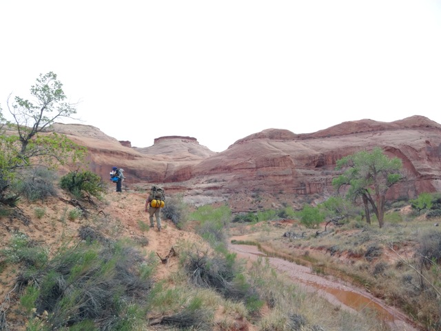
Grand Gulch 2018 (May 19-25, 2018)
|
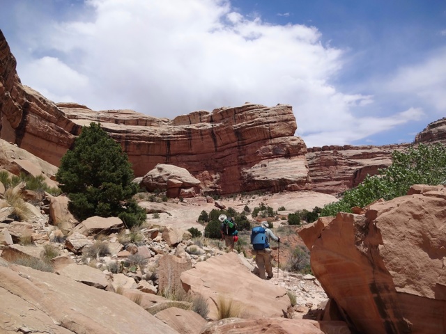
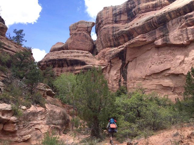
This was our 17th trip to the canyons of Utah. We had big plans but with the dual factors of heat and a severe drought in Grand Gulch made it necessary for us to change our plans. We originally planned to hike down Bullet Canyon and then continue down Grand Gulch to Green House Canyon. Then we planned to backtrack back up Grand Gulch past Bullet and then exit out Sheiks Canyon. After exiting Sheiks, we were going to go down Road Canyon for one night before returning home.
Unfortunately, it was much hotter and drier than it was even in 2017 when we thought it was pretty hot and dry. Basically, we ended up with a much shorter trip by eliminating our hike and camp at Green House Canyon and instead spending a rest day at our camp in Sheiks Canyon. We also shortened the hike a day by eliminating the Road Canyon part of the trip.
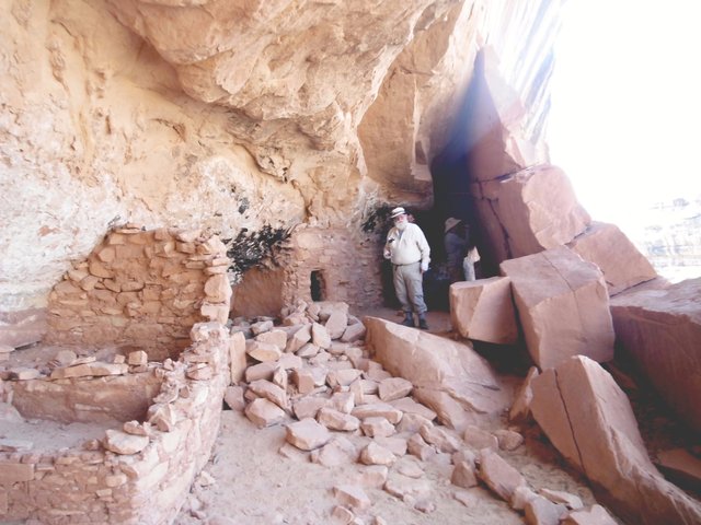
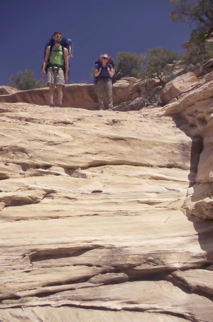
Even with the abbreviated plans, the trip had many interesting things to see and discover. The hike down Bullet and exit through Sheiks are two of the most challenging of the usual entrances to the Gulch. In going down Bullet, we retraced the start of our initial Utah hike in 2000. The exit via Sheiks was the first time, although we had been up Sheiks to the Green Mask Panel several times before, the latest in 2016.
Maybe it's just because I'm older, but the hike down Bullet seemed much harder and took longer. Certainly the heat had an effect as well. I was really worried about coming out Sheiks because of how it was described in the guide books, but although strenous (for me at least) it was doable and enjoyable.
One of the unfortunate things to come about on the trip was that the SD card that Mike had used in his GoPro for most of the trip was lost after he put in a new card on our second day. Lost were all the videos he took coming down Bullet, including Perfect Kiva and Jailhouse Ruin.
Kickass Trekkers on this trip were: Bill Mooseker, Shelby Stong, Fred Stong, Will Stong, Mike Stong, and Allan Hoseth
|
Troop 24 Kickass Trekkers: "The High Adventure Troop" Alumni Backpacking Trip
-Cascade Bill Mooseker
|
|
| 2.
2017 Grand Gulch, UT (May 20-26, 2017)
|
This was our 16th trip to the canyons of southern Utah. The trip continued down Grand Gulch from where we left off in 2016. I had also hiked down this stretch of the canyon in 2000, but at a much faster pace. Highlights of the trip included some spectacular ruins and pictograph panels that we had visited before and some that we had not. Again the ever changing vistas, and majestic canyon walls were a delight.
I'd like to thank my hiking companions for making the trip possible for me: the youthful Nicks for their energy and enthusiasm; Will for his humor; and the indefatigable Mike for his infectious joy of life, which inspired all of us.
Because we had only one car, we were fortunate to be able to use the shuttle services of Four Corners Adventures to arrange to leave our vehicle at the Collins Canyon Trailhead, so it would be there when we came out at the end of our trip. Four Corners Adventures was very accommodating in setting up the shuttle to suit our needs.
I've made a Google Map for this trip which can be found HERE. It shows us going below the Narrows, which we did not do because of the water situation.
Kickass Trekkers on this trip were: Bill Mooseker, Will Stong, Mike Stong, Nick McMahan, Nick Tuggle
|
Troop 24 Kickass Trekkers Backpacking Trip
-Cascade Bill Mooseker
|
|
| 3.
2016 Grand Gulch Utah (May 7-May 12 2016)
|
This was our 15th trip to the canyons of southern Utah, repeating our 2002 and 2005 trips except in the opposite direction. Highlights of the trip included many ruins and pictograph panels as well as the ever changing canyon vistas.
The descriptions under the photo thumbnails in the album sometimes contain links to maps or additional information. These are identified by "Blue” text for links.
In this photo album, I've used links to Google Maps to show where certain photos in the album were taken or to locate features shown in the photos. Click on the link and close the sidebar. Basically, you can then zoom in and out using the mouse wheel or drag the map by clicking and holding.
Note photo takers are given in the titles under the thumbnails
Kickass Trekkers on this trip were: Bill Mooseker, Shelby Stong, Mike Stong, Fred Stong, Cindy Stong, and Madison Stong.
|
Troop 24 Kickass Trekkers: "The High Adventure Troop" Alumni Backpacking Trip
-Cascade Bill Mooseker
|
|
| 4.
2015 Crystal Lake (Sept 5-7, 2015)
|
|
Labor Day 2015
Crystal Lake
|
|
Fish Fry at Crystal Lake
|
|
We had big plans for a hike along scenic Meadow Mountain in the Glacier Peak Wilderness, but the weather was not cooperative and we had to scale back our plans. We hiked into Crystal Lake, a distance of a little over four miles. The hike is pretty much of a valley pound following old logging roads for much of the distance, then a scramble straight up the side of the mountain for a climb of about 300', and finally by trail through the forest and then the meadows below the lake.
Even though the trail follows old logging roads much of the way, nature has been busy reclaiming the area, making for a very brushy ascent at various stretches along the trail. We got to the lake in good time, about 3 pm, leaving us plenty of time for fishing and setting up camp.
The lake is a typical sub alpine Cascade lake - ringed by evergreens, but with a meadowed fringe that makes for a quite beautiful setting. Our hike in day was mostly cloudy, with a few sunny patches, but everthing got drenched as heavy rains began late at night. Shelby and Roger had some leakage problems in their tents, but while I dodged that problem, my tent site was on a slope so I was scrunched up to one side of the tent all night.
So instead of hiking up over the pass between Crystal and Meadow Lakes and heading out Meadow Mountain, we elected to stay in camp. So we followed the sage advice of fellow Kick Ass Trekker, Jason Smith, who after a very short day in Idaho's Sawtooth Wilderness, asked "Why should we go on hiking another six hours to get to some lake, when we are already at one?" So we hung out, fishing in the rain, warming up at the campfire, and drying out wet sleeping bags.
Kickass Trekkers on this trip: Bill Mooseker, Roger Shively, and Shelby Stong.
|
Troop 24 Kickass Trekkers Backpacking Trip
-Cascade Bill Mooseker
|
| 986 Visits, 26 Images, Shared Album |
|
| 5.
Slickhorn Canyon - Utah (May 11-17, 2015)
|
|
Slickhorn Canyon, Utah
May 2015
Day 0: May 12:
Explore rim of Todie Canyon
Camp at Trailhead for Todie Canyon.
Day 1: May 13:
Head down Access #4 to Camp 1 at meadow.
Day 2: May 14:
Continue down Access #4 to mouth of Slickhorn.
Hike up Slickhorn to Camp 2 near mouth of Access #2.
Day 3: May 15:
Dayhike up Slickhorn from Camp 2 to visit Kiva Ruin
and other ruins above 2nd Access.
Head down canyon past Access #4 to Camp 3 at
mouth of Trail Canyon (Access #6).
Day 4: May 16:
Start up Trail Canyon (Access #6) & visit Big Ledge Ruins
Continue up canyon to trailhead, retrieve car, &start long drive back.
|
|
Nick & Allison - Pondering How to Get Down Dropoff
|
|
For our fourteenth trip to the canyons of southern Utah, we did a partial repeat of our 2004 trip to Slickhorn Canyon. This was mainly due to traveling in one car limits your options for a loop trip. This is a very scenic canyon complex with many opportunities for visiting ruins or Anazazi art.
While hiking in the main Slickhorn Canyon is fairly easy, going in and out via the access canyons is fairly hard for a 60 year old (as I was in 2004) and even more so as a 71 year old. I'm ever grateful to the younger Kickass Trekkers for making it possible for me to continue doing what I love. In 2004, I wasn't thinking about how much longer I would be backpacking, but now I realize that each year onward is a gift.
Note photos ending in "b" are by Bill; "a" are by Allison; and "j" by Joel.
Kickass Trekkers on this trip were: Bill Mooseker, Joel Fuller, Nick McMahan, and Allison Walkingshaw.
The descriptions under the photo thumbnails in the album sometimes contain links to maps or additional information. These are identified by "Blue” text for links. I've also inserted links to Google Maps to show where certain photos in the album were taken or to locate features shown in the photos. Click on the link, close the sidebar, and choose satellite view. Basically, you can then zoom in and out using the mouse wheel or drag the map by clicking and holding.
The thumbnails do not do justice to petroglyphs and pictographs, so I would recommend enlarging them as well. Please take the time to view the videos to better experience what it was like to be there.
|
Troop 24 Kickass Trekkers Backpacking Trip
-Cascade Bill Mooseker
|
| 16933 Visits, 375 Images, Shared Album |
|
| 6.
2014 Utah: Robbers Roost II (April 14-19, 2014)
|
|
Robber's Roost Canyon, Utah
April 2014
|
|
Mike & Fred Near Mindbender Fork Junction
|
|
In 2011, the Troop 24 Kickass Trekkers made a trip to Robber's Roost Canyon near Hanksville, Utah. Because of limited time, we were not able to explore the upper reaches of the canyon and only made it as far as the mouth of White Roost Canyon. The photo album of that trip can be found HERE. At the time I regretted that I probably would never get the chance of a return trip, as opportunities are limited when you are approaching 70 years of age.
But this year, as I was looking for a Utah trip that would allow dogs as well as a large group, the idea of returning to Robber's Roost Canyon was appealing as both were allowed. However, I didn't want to redo our 2011 trip by entering the mouth of the canyon via the Dirty Devil. In 2011, the rest of the group went up the White Roost and found what is called the “White Roost Exit”. I thought that if we could enter the canyon by using this exit, we could explore the upper reaches of Robber's Roost that we were not able to do in 2011.
Robber's Roost Canyon gets its name from the legendary Wild Bunch gang that included the famous outlaws, Butch Cassidy and the Sundance Kid. A history of the Wild Bunch and the Robber's Roost hideout can be found HERE.
After my two trips here, I must say that this canyon complex is probably my favorite of all the places we've hiked in Utah.
Somehow we were able to fit 10 people, one dog, and all our food and gear into two vehicles for the drive down to Utah (Fred drove up from New Mexico). I didn't think it could be done.
Note photos ending in "bill" are by Bill M; "mike" are by Mike Stong; and "Austin" by Austin Peckinpaugh.
Kickass Trekkers on this trip:
Bill Mooseker, Gary Shively, Roger Shively, Kevin Shively, Fred Stong, Shelby Stong, Derek Stong, Mike Stong, David Brown, Austin Peckinpaugh, Danny Stallings, and Walter "The Wonder Dog".
The descriptions under the photo thumbnails in the album sometimes contain links to maps or additional information. These are identified by “Blue” text.
I've also prepared a Google Map of the trip with links to photos taken at or near the marked location. The map can be found HERE.
|
Troop 24 "Kickass Trekkers" Backpacking Trip
-Cascade Bill Mooseker
|
| 35622 Visits, 450 Images, Shared Album |
|
| 7.
2013 Pyramid (08/31/13-09/02/13)
|
|
Pyramid Mountain
Glacier Peak Wilderness
Labor Day Weekend - 2013
|
Danny, Shelby, & Meghan
Sandblaster High Route
|
|
This was my sixth trip to Pyramid Mountain. It is one of my favorite trails, starting high with views as you traverse high ridges. We had good weather and as usual, Shelby came up with something new for this trip (See photos).
I had originally planned to do a somewhat reverse trip of what we did in 1998 (CLICK HERE) but we opted to not follow the trail over to the North Fork of the Entiat valley, but instead come out via the South Pyramid Creek Trail.
The descriptions under the photo thumbnails in the album sometimes contain links to maps or additional information. These are identified by "Blue” text.
|
Troop 24 "Kickass Trekkers" Backpacking Trip
-Cascade Bill Mooseker
|
| 1274 Visits, 32 Images, Shared Album |
|
| 8.
08 Kickass III -2012 (08/26/12-09/01/12)
|
|
Kickass III - August 2012
Day 1: Phelps Cr to Spider Meadow
Day 2: Spider Meadow to Lyman Lake
Day 3: Lyman Lake to Image Lake
Day 4: Image Lake to Miner's Creek
Day 5: Miner's Creek to Buck Creek Basin
Day 6: Buck Cr Basin to Massie Lake
Day 7: Massie Lake to Trinity
|
|
Heading Down Snowfield to Lyman Basin
|
|
Attendees: Bill Mooseker, Fred Stong, Mike Stong, Shelby Stong, Jill Stong, Roger Shively, Danny Stallings.
This photo album documents a week long backpacking trip by the Troop 24 Kickass Trekkers in August 2012. In fact it was basically this hike in 1997 that put the "Kickass" in our name, when Bill Peckinpaugh made the observation that this hike "really kicks your ass!". The 1997 hike was thereafter known as Kickass I.
Originally we had planned to do a trip in the Pasayten, but time constraints and accomodating travel plans ruled that out. This is the fourth time that I've done most of this route (1980, 1983, 1997) and as I've reached the age (69) where I realize that it is the last time, which is kind of sad as this is probably one of the most challenging and scenic trips around.
Normally I've started this route by following the Carne Mountain/ Leroy Creek High Route, but that would have required another night on the trail, and we didn't have that available. Instead we just hiked directly to Spider Meadow (one of my favorite camps) rather than arriving there on the third night. From there the route goes over Spider Gap down to Lyman Lake; from Lyman Lake to Image Lake; Image Lake to Buck Creek Pass;and, finally, retracing the Massie Lake High Route in reverse from our 2001 Kickass II hike, before returning to Trinity via the Chiwawa Basin Trail.
Included in the album are photos by Roger (file names ending in "r"); Jill and Shelby (file names ending in "j");and, Mike Stong (file names ending in "m"). Note that Jill's photos were copied from her Facebook albums and are fairly low resolution.
|
Troop 24 Kickass Trekkers Backpacking Trip
-Cascade Bill Mooseker
|
| 6951 Visits, 424 Images, Shared Album |
|
| 9.
Dark Canyon 2012 (May 15 -19, 2012)
|
|
Dark Canyon Wilderness, Utah
May 2012
|
|
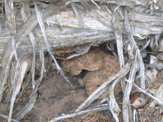
Don't Tread on Me! - Canyon Resident We Met on Trail
|
|
Attendees: Bill Mooseker, Fred Stong, Joel Fuller, Nick McMahan
This was the 12th springtime trip to Utah's Canyons for the Troop 24 Kickass Trekkers. There were only four of us for this trip. I've often wondered about going to Dark Canyon, but the trailheads are above 8000 feet and usually are snow covered when we usually make our trips.
This year we were making the trip in mid May, and the access roads were open. It takes two days to reach the trailhead from Lynnwood. After a long, long first day we overnight in Tremonton, Utah (about a 700 mile day)
The next day was much shorter and we hoped to meet Fred at the National Bridges National Monument Headquarters in mid afternoon, but it took us longer as we were wandering all over Price, UT to find an auto parts store to get some fuses to fix the taillights on the Gray Ghost.
It was late afternoon when we pulled into the parking lot at National Bridges NM. We sorted out our gear and got our packs ready and transferred them to Fred's truck. Taking off we made our way on a fairly good dirt road up and through the Bear's Ears. We dropped the car off at the Peavine Trailhead and all of us piled into Fred's Truck for the long drive to the Big Notch Trailhead.
The Dark Canyon Wilderness is very remote, and we did not see many people during our trip. It was quite different from our other canyon treks due to the higher elevation. Water was a concern as 2012 was a very dry year, and any visitor should consult local sources for the latest information before making a trip here.
In order to locate where the photos in the album were taken i've used the online map tool, Acme Mapper. This is a superb application which gives you linked topo and aerial photo (google) maps. I used to use some Bing maps but those didn't work anymore, so I've converted them to Google Maps.
Note that photo titles ending in "Joel" are by Joel Fuller. The rest are mine.
|
Troop 24 Kickass Trekkers Backpacking Trip
-Cascade Bill Mooseker
|
| 7641 Visits, 214 Images, Shared Album |
|
| |