Old Farts on this trip:
Bill Mooseker, Gary Shively
Former Scouts on this trip:
Shelby Stong, Roger Shively, Kyle Meissner, Danny Stallings, Kevin Shively
This was our fourth trip to the Utah Canyons. Our previous treks were through canyons that were relatively dry and any running water would at best be a minor trickle. The Escalante on the other hand is a major river. We weren't mentally prepared for the fact that we would have to cross it many times each day.
In retrospect, we were lucky that we made the trip in March rather than later. The effect of snowmelt in April and May significantly increases the flow in the river, which would have made much more difficult, if not impossible, to comfortably (not to mention safely) make the number of river crossings necessary. The fact that the Snow Pack for Utah in 2003 was below average was also in our favor.
In addition, in March, leaves are just beginning to come out. The bushwhacking that we had to do was hard enough as it was without doing it through fully vegetated terrain. We were also lucky in that we didn't have any extremely cold weather until our last day, when we were in the upper reaches of the relatively dry 25 Mile Wash. It is unthinkable even to imagine making a crossing of the Escalante in freezing temperatures.
Photos ending in "r" taken by Roger
The descriptions under the photo thumbnails in the album sometimes contain links to maps or additional information. These are identified by "Blue” text for links.
Note: September 2025 - I have added maps (JPG files suitable for printing) for each day of the hike from online CalTopo maps described below. I have also added a table for miles traveled along with the elevation gains and losses between the points shown on the map.
Links to Caltopo maps for that day's hike are given in the description under the map thumbnail. Viewing the Caltopo map online also gives the option of using several different base layers (I have used the Google Satellite layer for this album).
Maps are best viewed at "Original" size. To view at "Original" size, click on Thumbnail to enlarge the map, then click again to access the original resolution. Move the cursor to the point on the map that you want to enlarge and then click the cursor to zoom in or out.
An explanation of how I have derived the distances and elevation gain/losses can be found HERE.
Note: September 2025 - I have replaced the original low resolution images that I had taken with with high resolution ones scanned in from negatives. Photos by Roger were taken with a digital camera and have not been replaced. I have also added videos from the trip to the album.
Troop 24 Kickass Trekkers: "The High Adventure Troop" Alumni Backpacking Trip
-Cascade Bill Mooseker
Date(s): March 2003. Album by Cascade Bill Mooseker. Photos by WHM & Roger. 1 - 269 of 269 Total. 10435 Visits.
enlarge 453KB, 1280x805 1 ut2003-D1a DAY 1
Day 1: Hiking down Harris Wash from the Trailhead to Camp 1
The online version of this Caltopo map can be found HERE.
Due to a lucky break by getting our shuttle ride switched from Monday morning to Sunday afternoon we didn't have to camp at the trailhead as planned but were able to go down the wash almost to the Glen Canyon NRA boundary for our first camp.
enlarge 82KB, 1440x547 2 Escalante 2003-1
Tabulation of distance hiked and elevation gained. Waypoints correspond to those shown on the Caltopo Map.
enlarge 341KB, 1280x830 3 ut03001r
Our original plan was to camp at the Harris Wash trailhead Sunday night and meet Escalante Outback Adventures shuttle on Monday morning to transfer the car to the 25 Mile Wash trailhead. Fortunately, the EOA guy was in his store in Escalante when we arrived and he agreed to do the shuttle that afternoon. Here we are unloading the Suburban at the Harris Wash Trailhead.
enlarge 386KB, 1440x809 4 ut03002r
While Bill and Gary drove to the 25 Mile Wash TH to meet the EOA shuttle to bring them back, the guys had a little fun at the Harris Wash Trailhead - Here Danny and Shelby have tied branches on their heads and are impersonating deer.
"these are the sexiest deer i've ever seen... except t..." View Comments...
Shelby, Kyle, and Danny atop a little mound near the Harris Wash Trailhead. You can see that the country is fairly open with no discernable canyon.
enlarge 46.94MB, 1440x810 8 2003 Escalante Day 1-01a.mp4 VIDEO - Click "Download MPEG4"to View.
Imageevent's video player will not play this video
Heading out late in the day after a long car shuttle.
enlarge 332KB, 1280x852 9 2003-390-011
We got a late afternoon start down the wash. This is in the wash very near the trailhead.
enlarge 270KB, 916x1280 10 2003-390-012 Soon sandstone walls appear on our right heading down the wash.
enlarge 375KB, 936x1280 11 2003-390-013 Gary, Shelby, Kyle, and Roger.
enlarge 411KB, 1280x899 12 2003-390-014
The "fence" mentioned in the guidebooks to keep cows out of the lower wash - 3 miles from the trailhead. However, We did see some very wild cattle later that trip down in the Escalante Canyon.
enlarge 629KB, 1280x960 13 ut03011r
We found a sandy spot opposite a side canyon just short of the NRA Boundary for our first camp.
enlarge 407KB, 1280x960 14 ut03013r Shelby and Kyle have fun with a deer backbone they found in camp.
enlarge 454KB, 1280x805 15 ut2003-D2a DAY 2
Day 2: Camp 1 to Escalante River (Camp 2) Part 1
The online version of this Caltopo map can be found HERE.
This was a long day down the wash with a side trip exploring a side canyon opposite the Narrows. Most of the hikers coming up the wash told us the Escalante was too high for fording but we ended our day with a nerve wracking ford of almost crotch deep Escalante to our best camp of the trip a little down stream of the mouth of Harris Wash.
enlarge 513KB, 1280x805 16 ut2003-D2b Day 2: Camp 1 to Escalante River (Camp 2) Part 2
enlarge 283KB, 1280x1011 17 Escalante 2003 Day 2
Tabulation of distance hiked and elevation gained. Waypoints correspond to those shown on the Caltopo Map.
enlarge 293KB, 1280x908 18 ut03014 Breakfast at Camp 1 - Danny and Shelby.
enlarge 249KB, 758x1280 19 ut03015 Bill at Camp 1 "bill, you are immortal" View Comments...
enlarge 352KB, 1280x902 20 2003-390-015 Packing up - You can see the good use Shelby puts his lawn chair to.
enlarge 334KB, 892x1280 21 2003-390-016 view of camp - you can see the canyon walls across the wash.
enlarge 597KB, 1280x960 22 ut03018r Super Tiogas for Kyle and Shelby.
enlarge 328KB, 1280x849 23 ut03019r The Gang: Danny, Roger, Gary, Kevin, Kyle, Shelby, and Bill.
enlarge 288KB, 885x1280 24 ut03020
Garry on a rock outcrop at Camp 1. This outcrop provides a good spot to sit - a lot of Escalante camps don't have any such spots.
enlarge 544KB, 1280x960 25 ut03012r Danny getting his music ready for the hike. "here, my walkman is broken, causing me to panic" View Comments...
enlarge 355KB, 826x1280 26 2003-390-017
Heading out - this is just down canyon from our camp. You can see the canyon walls are quite impressive here. The NRA boundary is just around the bend.
enlarge 47.34MB, 1440x810 27 2003 Escalante Day 2-01a.mp4 VIDEO - Click "Download MPEG4"to View.
Imageevent's video player will not play this video
Heading down Harris Wash near the Glen Canyon NRA Boundary
enlarge 672KB, 1280x960 28 ut03022r Gary and Kevin at the Glen Canyon NRA Boundary
enlarge 449KB, 960x1280 29 ut03023r
As you can see, the wash has quite a flow of water here - the water shoes sure come in handy. Just down canyon you can see the Harris Wash narrows (noted on the map above as D2-05 Rincon Narrows).
enlarge 297KB, 860x1280 30 2003-390-018
Harris Wash Narrows - This is the narrowest spot in Harris wash. The river has pinched out a meander and left it high and dry as it carved this channel through.
enlarge 422KB, 1280x1121 31 ut3025ar
Looking back upcanyon from the Narrows. A side canyon joins the wash here on the left. We dropped our packs and explored up this side canyon. We didn't notice it at the time but the scratches on the rock behind Gary could be writing - Enlarging the photo, I can make out "Wayne" on the first line, then .......UR on the second. I can't decipher the 3rd (Maybe 1934??). - It's definitely not an ancient pictograph but could be historical.
enlarge 369KB, 936x1280 32 2003-390-020
We explored the side canyon coming into Harris Wash at the narrows. It was rough going but with good views. Note the fallen cottonwood spanning the wash.
enlarge 418KB, 856x1280 33 2003-390-019
If you look closely (Enlarge thumbnail) you can see Roger standing on the cottonwood that has fallen across the wash.
enlarge 34.19MB, 1440x810 34 2003 Escalante Day 2-02a.mp4 VIDEO - Click "Download MPEG4"to View.
Imageevent's video player will not play this video
We ditched our packs and explored a side canyon (Rincon Narrows Marker on the Caltopo Map).
enlarge 512KB, 1280x852 35 ut03028r Shelby, Kevin, and Kyle at the big cottonwood.
enlarge 258KB, 1280x832 36 2003-390-021 Bill exploring side canyon.
enlarge 405KB, 1280x832 37 ut03030r The stream from the side canyon has cut this alcove.
enlarge 311KB, 850x1280 38 2003-390-022 Shelby, Danny, and Kyle - Leaving the Narrows - as you can see the sky is clouding up.
enlarge 346KB, 860x1280 39 2003-390-023 Another shot of the narrows
enlarge 321KB, 962x1280 40 ut03033 Close up. "we appear to be forming a wall in hopes of stopping a..." View Comments...
enlarge 435KB, 1280x837 41 ut03034r Roger - at bend in wash. You can see that you wouldn't want to be here during a flash flood.
enlarge 32.40MB, 1440x810 42 2003 Escalante Day 2-03a.mp4 VIDEO - Click "Download MPEG4"to View.
Imageevent's video player will not play this video
Heading down Harris Wash
enlarge 247KB, 849x1280 43 2003-390-024 Gary heading down the wash.
We lost our sun and soon had some showers - here we are taking a break almost all the way down the wash.
enlarge 333KB, 982x1280 46 2003-390-025
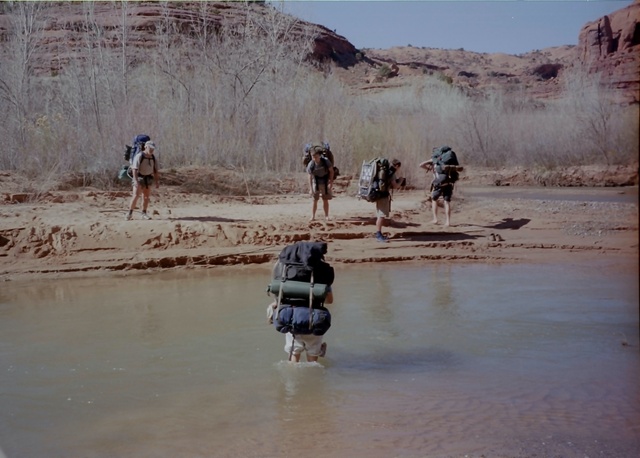
Danny crossing over the bench. From here you can see the next bend, which is where the Harris Wash meets the Escalante. The magnificent rock formation on the right looks like a castle guarding the entrance to Harris wash. You can see this formation from the Escalante as well. Contrary to what the other hikers told us, we were able to cross the Escalante (although it was pretty daunting the first time as it was almost at crotch level).
enlarge 575KB, 805x1280 47 ut2003-D3a DAY 3
Day 3 Map 1: Escalante River from the Mouth of Harris Wash to just Upriver from Neon Canyon
The online version of this Caltopo map can be found HERE
This was a long day along the Escalante with an extended break at Choprock Canyon where we did some exploration and inspection of a petroglyph panel near the mouth of the canyon. I don't know how many times we crossed the river but the crossings were so numerous that you soon lost count.
enlarge 578KB, 805x1280 48 ut2003-D3b Day 3 Map 2: Escalante River from the Mouth of Harris Wash to just Upriver from Neon Canyon
enlarge 228KB, 1280x901 49 Escalante 2003 Day 3
Tabulation of distance hiked and elevation gained. Waypoints correspond to those shown on the Caltopo Map.
enlarge 739KB, 1280x960 50 ut03040r
Danny - another in a string of tentless nights extending back to 1999. Danny had found a nice spot with a rocky overhang, but when Shelby caught a small scorpion where he was going to sleep, Danny moved to this spot - far away from any rock outcrops.
enlarge 236KB, 1440x846 51 scorpian Would you sleep near this?
enlarge 300KB, 1280x960 52 ut03041r
Looking Southeast from our camp on the Escalante. The canyon below the mouth of Harris wash is wide and open as you can see here.
enlarge 457KB, 1280x960 53 ut03042r
Rock formation on our side of the river - All the camps in Harris Wash near the Escalante were occupied so we had to cross the Escalante with some trepidation because we had met a stream of people coming back up the canyon who told us the Escalante was too high for fording. We were pretty worried as we had to go a long ways down the river to get to 25 Mile Wash. Fortunately, the river was only mid thigh deep and we crossed without incident.
enlarge 455KB, 1280x960 54 ut03044r Another view of the "Castle" and the mouth of Harris Wash.
enlarge 681KB, 1280x960 55 ut03048r A cactus at our camp.
enlarge 538KB, 1280x960 56 ut03045r
Getting ready to pack up. You can see the overhanging outcropt that Danny wanted to sleep under before Shelby caught the scorpion.
enlarge 617KB, 1280x960 57 ut03046r Kyle and Kevin - packs on.
enlarge 607KB, 1280x960 58 ut03047r Kevin, Danny, and Shelby - ready to roll.
enlarge 268KB, 1280x835 59 2003-391-001
Looking back towards the mouth of Harris wash, which is out of sight to the right of the picture. The "castle" we saw the previous day as we came down the was is visible here on the right across the river. You can see that the guys have their packs on and are ready to roll.
enlarge 31.55MB, 1440x810 60 2003 Escalante Day 3-01a.mp4 VIDEO - Click "Download MPEG4"to View.
Imageevent's video player will not play this video
With packs on, we leave Camp 1
enlarge 545KB, 1280x960 61 ut03049r
The canyon was nice and wide as we started out but it wasn't long before the river meandered over to our side of the canyon, forcing us to cross to the other side. This view is looking down river.
enlarge 59.67MB, 1440x810 62 2003 Escalante Day 3-02a.mp4 VIDEO - Click "Download MPEG4"to View.
Imageevent's video player will not play this video
Gary & Danny Crossing the Escalante
Our First crossing of many for the day
enlarge 281KB, 1280x916 63 2003-391-002 Our first crossing of many that day - Kevin in midstream.
enlarge 292KB, 1280x837 64 2003-391-003 I'm glad the early morning sun was out as that water was cold.
enlarge 462KB, 1280x960 65 ut03052r Danny clearing his head at the first crossing.
enlarge 310KB, 967x1280 66 2003-391-004 Crossing No. 2 - and pretty soon you lost count of how many times you had crossed.
enlarge 375KB, 943x1280 67 2003-391-005 Interspersed with the river crossings was hiking over long sandy benches
enlarge 347KB, 1280x841 68 2003-391-006 We took a break on this bench.
enlarge 594KB, 1280x960 69 ut03056r Danny, Gary, Kevin - getting ready to head out after a short break. It was really warming up.
enlarge 662KB, 1280x960 70 ut03057r Gary,Kevin, Kyle, and Shelby
enlarge 39.48MB, 1440x810 71 2003 Escalante Day 3-03a.mp4 VIDEO - Click "Download MPEG4"to View.
Imageevent's video player will not play this video
Literally hiking down the river
enlarge 400KB, 1280x960 72 ut03059r
This was a pretty hairy crossing - we crossed from right to left and then had to go back to the right side past this rock outcrop. The water was very deep as it came around the bend up against the rock.
enlarge 305KB, 1130x1280 73 2003-391-010
Roger and Kyle entering the water at the outcrop. You can see from the wake at Roger's leg that the current was pretty swift.
enlarge 314KB, 1280x874 74 2003-391-011 Garry, Kevin, Roger - Kyle is trying to find the best way in.
enlarge 284KB, 1440x807 75 ut03062r
Shelby and Kevin tried to make a go of it along the outcrop - you can see that the water has gone above their shorts - Mr. Commish won't like that. You can see the sandy beach at the end of the outcrop where we have to pull out. These double crossings wear you out.
enlarge 521KB, 1280x960 76 ut03063r
Another crossing - you can see that the vegetation along the banks is very thick which makes it difficult sometimes to get in or out of the river.
enlarge 429KB, 1280x960 77 ut03064r
Here is another "Double" crossing - you can see ahead that you have to stay on the left side but the outcrop forces you to cross to the right bank. There is no point in fighting the vegetation, so you just go along the bank and cross back over when you are opposite the beach up ahead.
enlarge 485KB, 1280x960 78 ut03065r
Roger in midstream - you can see Danny up on the bank behind the bushes - He liked to cross barefoot, so he always took his shoes off. This is a typical crossing as you have a plunge down the bank into the water.
enlarge 554KB, 1280x960 79 ut03066r Gary coming across
enlarge 563KB, 1280x960 80 ut03067r Here comes Kevin and Bill.
we had to cross this stupid river so god damn many times (04/15/04) - Danny
enlarge 372KB, 965x1280 81 2003-391-007 Finally Danny comes across.
enlarge 647KB, 1280x960 82 ut03069r
While it was hard to get in the river at times, it was even more difficult to get out sometimes - here Shelby deals with a steep muddy bank.
enlarge 496KB, 1280x960 83 ut03070r
Another "Double" crossing - the river meanders between the canyon walls on either side. At least on this one we had a beach to pull out on before we did the second crossing.
enlarge 376KB, 1064x1280 84 2003-391-008
For most of the way there isn't much of a trail - you just haul out into the brush and keep heading down river. In a while some tracks will merge and there will be a trail of sorts.
enlarge 343KB, 1011x1280 85 2003-391-009 Roger in a Kodak moment.
enlarge 661KB, 1280x960 86 ut03058r
Putting the camera away after a shot. - this is pretty typical of the travels across a bench between river crossings.
enlarge 55.37MB, 1440x810 87 2003 Escalante Day 3-04a.mp4 VIDEO - Click "Download MPEG4"to View.
Imageevent's video player will not play this video
Away from the river - Hiking across a sandy bench
enlarge 281KB, 1280x960 88 2003-391-012 Away from the river's edge it often opens up giving a nice view of the canyon walls ahead.
enlarge 330KB, 1440x783 89 ut03074r
We took a break for lunch - Roger and Shelby climbed up the southern wall of the canyon on a day hike.
enlarge 450KB, 1280x926 91 ut03076r Roger - in photographer mode.
enlarge 364KB, 862x1280 92 ut03077r In honor of Buckwheat (See 1998 Bridger Wilderness hike) Roger strikes a pose.
enlarge 347KB, 1440x752 93 ut03078r Roger on outcrop.
enlarge 291KB, 786x1280 94 ut03079r Close up of Roger.
enlarge 382KB, 1280x830 95 ut03080r Shelby - They got pretty far up the side wall - you can see that there is a big bend in the river beyond Shelby.
enlarge 255KB, 1440x607 96 ut03081r Shelby - A composite picture - there is a small side canyon coming in across the canyon.
enlarge 429KB, 1280x904 97 ut03082r
Lynnwood's answer to the Crocodile Hunter - Shelby and lizard. This was the grove of cottonwoods where we stopped for lunch. It was possible to get a little shade.
enlarge 366KB, 842x1280 98 ut03083r Saddling up - Roger.
enlarge 495KB, 1280x839 99 ut03084r Ready to hit the trail - Kyle, Shelby, and Gary leaving cottonwoods where we had lunch.
enlarge 534KB, 1280x960 100 ut03085r
Bill pondering the route downriver - this is at the mouth of Choprock Canyon, the first major side canyon coming in on the north side of the river.
enlarge 311KB, 1280x854 101 2003-391-013
Even though we had taken a long lunch break a short ways up the river, we decided to stay awhile at Choprock for a little relaxation and exploration.
enlarge 290KB, 1280x994 102 ut3087r Kevin in the mud - Choprock Canyon mouth. you can see the small stream beyond Kyle.
enlarge 420KB, 1280x824 103 ut03088r Shelby and Kyle getting into the "mud" business.
enlarge 260KB, 1280x906 104 ut03089 These are professional hikers on a closed course - do not try this at home.
enlarge 310KB, 1280x817 105 ut03090r As usual the lawn chair has many uses - here it gives a perfect spot to cool down.
enlarge 463KB, 1440x892 106 ut03091r
The western wall of Choprock has a lot of wind eroded pockets - in this one a group of cacti have taken hold.
enlarge 493KB, 1280x829 107 ut03092r A near and far shot (the same group of cacti beyond)
enlarge 156KB, 1440x682 108 Lizard
enlarge 315KB, 1280x835 109 ut03093r
There were enought pockets to make hand and foot holds - here Gary climbs up the side wall of Choprock.
enlarge 290KB, 837x1280 110 2003-391-014 Kyle and Shelby - picking their way up the Choprock canyon sidewall.
enlarge 333KB, 849x1280 111 2003-391-015 Shelby and Kyle find a spot to sit down in.
enlarge 286KB, 1440x858 112 ut3096r Its pretty steep - Shelby going up the canyon wall.
enlarge 324KB, 1280x834 113 ut03097r Roger and Kyle going up.
enlarge 366KB, 982x1280 114 2003-391-017 You can see here the route the guys took up the side wall of the canyon.
enlarge 554KB, 1280x956 115 2003-391-016
While they were climbing the wall, I found this large hunk of petrified wood - a whole cross section of a trunk.
enlarge 400KB, 1280x927 116 2003-391-018 A little ways up the canyon is a large Petroglyph Panel. Here are some Bighorn sheep.
enlarge 291KB, 1280x844 117 2003-391-019
Sadly, there was quite a bit of vandalism of the petroglyphs. Here someone has placed his initials on the head of the "Spaceman". From what I could tell, the vandalism was historical - local ranchers from the 1800's to the early 1900's according to the dates carved in the rock.
enlarge 415KB, 1280x866 118 2003-391-020 An interesting pattern.
enlarge 46.54MB, 1440x810 119 2003 Escalante Day 3-05a.mp4 VIDEO - Click "Download MPEG4"to View.
Imageevent's video player will not play this video
Gary and Roger crossing the river below Choprock Canyon
enlarge 359KB, 847x1280 120 2003-391-021
As you can see, we spent a lot of time at Choprock and the sun is getting lower in the sky here as Roger and Gary are a few hundred feet from the mouth of Choprock.
enlarge 317KB, 1280x858 121 ut03107r
The sun is really sinking now - this is very near Fence Canyon. When we hauled out I sent Shelby and Danny ahead to find a campsite.
enlarge 445KB, 1280x960 122 ut03110r
Shelby and Danny in true "Butt Sniffing" tradition walk past a couple of camp sites that have everything - scenery, water, etc. and settle for this piece of crap - no view, far from water, - I wasn't too happy setting up my tent in this camp. Shelby is cooking dinner he is just finishing the pudding here - the Dragonfly and the FireFly roaring away. Gary is filtering water while Kyle looks on. If it weren't for the lousy camp all would be well.
enlarge 441KB, 1280x960 123 ut03108r I'm pitching my tent - its a good thing there is no audio file as I was doing this.
enlarge 483KB, 1280x960 124 ut03109r Danny as usual, hitting the books on his thermarest.
enlarge 647KB, 1280x960 125 ut03111r
The "Drying Tree" - no, it is not some new modern art work. Look at the color of the (white??) socks.
enlarge 572KB, 805x1280 126 ut2003-D4a DAY 4
Day 4 Map 1: Camp 3 Near Neon Canyon to mouth of 25 Mile Wash
The online version of this Caltopo map can be found HERE
Heading out from our crap camp we visited a pictograph panel, made side trips to Neon and Ringtail canyons.
enlarge 573KB, 1280x805 127 ut2003-D4b Day 4 Map 2: Camp 3 Near Neon Canyon to mouth of 25 Mile Wash
enlarge 350KB, 1252x1280 128 Escalante 2003 Day 4
Tabulation of distance hiked and elevation gained. Waypoints correspond to those shown on the Caltopo Map.
enlarge 245KB, 1280x885 129 ut03112 Camp 3 is in the books - here Kyle is packing up.
enlarge 259KB, 1280x931 130 ut03113
In their haste to find the campsite, Danny and Shelby had walked past this petroglyph panel which was a couple of hundred yards back up the trail from our camp. Here Kyle and Bill are looking at the panel.
enlarge 338KB, 863x1280 132 2003-391-024 Kevin, Shelby, Roger, and Kyle
Our camp was on the bench beyond the Petroglyph panel
enlarge 481KB, 1280x846 133 2003-391-023 Petroglyphs - more "bearpaws" here.
enlarge 428KB, 1280x839 134 2003-391-025 Kyle
A lot of different glyphs, some bearpaws. I didn't notice it at the time but up and to the left of Kyle there appears to be two boxers ??) if you enlarge the thumbnail.
enlarge 484KB, 1280x836 135 2003-391-022
There were some very complex figures in this panel. Note the similarity of the ball and wavy line at the bottom of the photo to the pictograph from Slickhorn Canyon (2004 hiking trips).
enlarge 305KB, 957x1280 136 ut03102 I tell you one thing, I wouldn't want to meet these guys some night in a dark canyon.
enlarge 374KB, 826x1280 137 2003-392-005
View of Panel - there had been some historical vandalism of this panel similar to the Choprock Canyon panel.
enlarge 298KB, 1280x841 138 2003-392-004 These were on a boulder at the Panel site.
enlarge 361KB, 1280x846 139 2003-392-003 Figures cut into a boulder at the site.
enlarge 383KB, 1280x833 140 2003-392-002 Shelby getting a close up of a panel detail.
enlarge 367KB, 1280x834 141 2003-392-006 Close up of Panel figure.
enlarge 356KB, 831x1280 142 ut03133r Guys at the mouth of Neon Canyon - getting ready to head up the canyon to the Golden Cathedral.
enlarge 341KB, 842x1280 143 2003-392-007
Near the mouth of Neon Canyon. This is a beautiful canyon that culminates in the Golden Cathedral. The close in walls, green vegeation, cottonwoods, boulders make it a very scenic sidetrip.
enlarge 117.12MB, 1440x810 144 2003 Escalante Day 4-01a.mp4 VIDEO - Click "Download MPEG4"to View.
Imageevent's video player will not play this video
After a short hike up Neon Canyon we come upon the wonders of the Golden Cathedral
enlarge 312KB, 863x1280 145 ut03125r Roger, Kevin, and Gary at the Golden Cathedral.
enlarge 248KB, 878x1280 146 2003-392-008
Roger and Kevin - you can see the pool of water below the two circular openings worn into the dome above.
enlarge 245KB, 845x1280 147 2003-392-009 Bill at the Golden Cathedral- this is a very special place.
enlarge 323KB, 833x1280 148 2003-392-012
Stepping back a bit you can see how the canyon walls come together and over time worn the dome above the pool. It's hard to appreciate the scale of this until you see images of people rappelling down thru the roof openings such as THESE
enlarge 306KB, 874x1280 149 2003-392-011 The light streams through the openings in the ceiling.
enlarge 261KB, 843x1280 150 2003-392-010 Another view
enlarge 323KB, 1280x848 151 ut03130r Roger
enlarge 302KB, 843x1280 152 ut03131r Roger at the Golden Cathedral.
enlarge 305KB, 829x1280 153 ut03132r
Looking up through the roof openings. it would really be something to see the water cascading down through these openings.
enlarge 333KB, 845x1280 154 2003-392-013
Looking back down Neon Canyon from the Golden Cathedral - you make your way between the canyon wall and this house sized diamond shaped boulder.
enlarge 311KB, 837x1280 155 2003-392-014
Kyle, Shelby, and Kevin - looking back up to the Golden Cathedral thru the opening between a house sized diamond shaped rock (as seen in the previous photo) and the canyon wall.
enlarge 58.89MB, 1440x810 156 2003 Escalante Day 4-02a.mp4 VIDEO - Click "Download MPEG4"to View.
Imageevent's video player will not play this video
Gary hiking back down Neon Canyon
enlarge 344KB, 834x1280 157 2003-392-015 The morning light and shadows here show the magic of Neon Canyon.
enlarge 509KB, 1280x960 158 ut03134r
At the mouth of Neon Canyon after our side trip up to the Golden Cathedral -Getting ready to head down the river.
enlarge 292KB, 1280x863 159 2003-392-016
Just beyond the mouth of Neon Canyon the trail goes across a wide bench and another petroglyph panel comes into view.
enlarge 387KB, 1280x837 160 2003-392-017 Details of Petroglyph Panel
enlarge 434KB, 1280x843 161 2003-392-018
enlarge 325KB, 933x1280 162 2003-392-019 Shelby - these vertical designs were eye catching.
enlarge 512KB, 1280x861 163 2003-392-020 A series of bighorn sheep figures.
enlarge 34.26MB, 1440x810 164 2003 Escalante Day 4-03a.mp4 VIDEO - Click "Download MPEG4"to View.
Imageevent's video player will not play this video
Roger & Kevin crossing the river between Neon and Ringtail Canyons
enlarge 394KB, 1280x960 165 ut03145r
A shortways downriver from Neon Canyon lies Ringtail slot canyon. At its mouth you have to do some boulder hopping and climbing to get into the canyon.
enlarge 276KB, 834x1280 166 2003-392-021 After climbing a bit, the canyon walls close in forming a slot .
enlarge 207KB, 923x1280 167 2003-392-022
Once you get used to the mucky bottom of the slot it is a lot of fun - here Roger and Kevin going around a bend.
enlarge 182KB, 846x1280 168 2003-392-023 Kyle and Shelby make their way up the slot.
enlarge 12.05MB, 1440x810 169 2003 Escalante Day 4-04a.mp4 VIDEO - Click "Download MPEG4"to View.
Imageevent's video player will not play this video
Roger making his way up the Ringtail Slot Canyon.
(Note: this is the last video for the trip. I think I recorded over the rest)
enlarge 211KB, 836x1280 170 2003-392-024
The chokestone in the bottom of the picture stopped my progress - I couldn't get under it and it looked too difficult to climb over so I took this picture of Shelby as he countiued up the slot.
enlarge 155KB, 838x1280 171 2003-392-025 Looking back the way we had come.
enlarge 297KB, 1440x795 172 ut03151r Kevin, Kyle, and Shelby going up Ringtail Canyon. (Enlarge Picture!)
enlarge 223KB, 748x1280 173 ut03152r Shelby tries a little bridging.
enlarge 198KB, 833x1280 174 2003-392-026 This is looking back at the entrance to the slot.
enlarge 638KB, 1280x960 175 ut03143r After our side trip up Ringtail, we had lunch- Bill's shoes tell the tail of the slot - mud, mud, and more mud.
enlarge 610KB, 1280x960 176 ut03144r Guys having lunch at the mouth of Ringtail Canyon - you can see the wash from Ringtail here.
enlarge 267KB, 1280x827 177 2003-392-027 A little bit of trail here as we come to the end of a bench for another river crossing.
enlarge 326KB, 968x1280 178 2003-392-028
Another "Double" crossing - at one of these we caught up to a group of college kids from California. One of the kids asked Shelby where we were going. Shelby said he didn't know. The kid replied, "Yeah, it's my first trip too." Shelby said, "No, you don't understand - we've been doing this for 10 years. None of us know where we are going - we just follow that old guy in the back" - About then I tumbled out of the brush and made the river crossing. I kind of wondered why I got a lot of funny looks.
enlarge 345KB, 1440x804 179 ut03156r
Shelby say's the hell with climbing up on the bench I'm just going to hike down the river for a while. Below Ringtail canyon, the river has a lot more bends
enlarge 310KB, 835x1280 180 2003-392-029
In the background is the mouth of Baker Canyon wihch comes in at a sharp bend in the Escalante. The trail climbs a bit above the river at this point. Danny with his usual late start after a break has caught up to me at this point.
enlarge 300KB, 1280x840 181 2003-392-030
Opposite the mouth of 25 mile Wash, we cross the river for the last time for that day - Here Gary and Roger are crossing. The sun was sinking fast so we were looking for a camp site.
enlarge 275KB, 842x1280 182 2003-392-031
We decided to camp on this sand bar just below the mouth of 25 mile wash - not a good place to camp if you are expecting flash floods.
enlarge 587KB, 1280x960 183 ut03160r
Bill clearing a space for his tent on the sand bar. As you can see it got pretty cold when the sun went down so out comes the pile sweater and hat.
enlarge 539KB, 1280x960 184 ut03161r No sweat for Danny - get out the book and the tape player.
enlarge 558KB, 1280x960 185 ut03162r
While we were setting up camp, a couple of strong wind gusts played havoc with our tents so Roger and Kyle went overboard guying there tent.
enlarge 623KB, 1280x960 186 ut03163r Kyle in the general disorder of the camp.
enlarge 547KB, 1280x960 187 ut03164r Another view of the tent guys.
enlarge 568KB, 1280x960 188 ut03165r The canyon wall next to our camp was scalloped with these depressions made by the ever present wind.
enlarge 468KB, 1280x960 189 ut03166r Kevin finds a catacomb to take a rest in.
enlarge 516KB, 1280x960 190 ut03167r Roger and Kevin.
enlarge 306KB, 841x1280 191 ut03168r Shelby - just hangin' around.
enlarge 481KB, 1280x960 192 ut03169r
Having dessert - One of the problems with camping along the Escalante is that most camps have no sitting logs. We were lucky in this camp with this log. - Kevin, Bill, Gary, Kyle, and Shelby. You can see the narrow mouth of 25 mile wash at top right (if you look carefully).
enlarge 307KB, 1280x960 193 ut03170r Roger's photo project - get close ups of trip participants - This is Danny.
enlarge 418KB, 1280x960 194 ut03171r Roger's Close up.
enlarge 302KB, 1280x960 195 ut03172r Kyle
enlarge 363KB, 1280x960 196 ut03173r Shelby
enlarge 339KB, 960x1280 197 ut03174r Kevin
enlarge 415KB, 1280x960 198 ut03175r
Looking down river from our camp - The college group came by quite some time after we had pitched camp. They finally found a camp aways downriver. We never saw them again.
enlarge 573KB, 1280x805 199 ut2003-D5a DAY 5
Day 5 Map 1: Up 25 Mile Wash to Camp 5
The online version of this Caltopo map can be found HERE.
Leaving the Escalante River behind we head up 25 Mile Wash hoping that our river crossing days were over. We didn't know about the busy beavers damming up the trickle that was 25 mile Wash. Although the dams were not wide they were much deeper and muddier than the Escalante.
enlarge 534KB, 1280x805 200 ut2003-D5b Day 5 Map 2: Up 25 Mile Wash to Camp 5
enlarge 240KB, 1280x916 201 Escalante 2003 Day 5
Tabulation of distance hiked and elevation gained. Waypoints correspond to those shown on the Caltopo Map.
enlarge 302KB, 866x1280 202 2003-392-032 Heading up 25 Mile Wash - near the mouth of the canyon. This is a very scenic stretch.
enlarge 346KB, 870x1280 203 2003-392-033 Kevin heading up 25 Mile Wash - this arch is forming on the west wall of the wash.
enlarge 591KB, 1280x960 204 ut03178r
A short ways up the canyon, we came across this line of "army" ants. They seem to be going in both directions.
enlarge 267KB, 886x1280 205 2003-392-034
The only ruin we saw on our whole trip was this small one that was totally inaccessible. There probably was a log ladder at one time that gave access, but that is long gone.
enlarge 489KB, 1280x960 206 ut03181r A close up of the ruin - you can see how hard it would be to get up there.
enlarge 563KB, 1280x960 207 ut03182r Another view
enlarge 599KB, 1280x960 208 ut03189r Taking a break - Lower 25 Mile Wash: Shelby, Gary & Kevin.
enlarge 300KB, 793x1280 209 ut03183r
After our break, we decided to explore a side canyon on the left (as shown on the map above) - Here Roger works his way up the canyon.
enlarge 306KB, 865x1280 210 2003-392-036
The canyon soon slots up - here Shelby and Roger are going into the slot. - There was a big pool (dry now) at the foot of this slot - it would be something to see a flash flood pouring thru the slot.
enlarge 178KB, 840x1280 211 2003-393-001
Roger in the slot which is really tight at the entrance with a waist high choke stone at the entrance.
enlarge 270KB, 862x1280 212 ut03186r Another view of Roger in the slot - looking back to the entrance. You can see the choke stone in front of Roger.
enlarge 293KB, 1280x857 213 ut03187r Shelby and Kevin going up the slot at the entrance.
enlarge 206KB, 1280x858 214 bill I didn't get far - It was really tight and I didn't want to get stuck trying to get over the choke stone.
enlarge 573KB, 1280x960 215 ut03191r Kyle and Bill - Packs on after our trip up the side canyon
enlarge 523KB, 1280x960 216 ut03192r Gary's ready to go.
enlarge 331KB, 953x1280 217 2003-393-002 The guys heading out after the break and exploring the side canyon.
enlarge 535KB, 1280x960 218 ut03193r Lower 25 Mile wash has many sandy benches such as this where the going is easy.
enlarge 361KB, 1280x855 219 ut03197r Gary and Roger making their way up to the petroglyph panel.
On our way up the wash, Roger spyed what he thought was another petroglyph panel. It turned out to be a real find.
enlarge 407KB, 1280x814 220 ut03203r A panoramic view of the panel.
enlarge 237KB, 1280x838 227 2003-393-006 There was no vandalism of this panel. Zoom in to get more details.
enlarge 411KB, 1280x830 228 2003-393-008 Big Box Bighorns
enlarge 355KB, 1280x838 229 ut03202r Roger got this shot of a flower in the rocks below the panel.
enlarge 221KB, 1280x933 230 liz
enlarge 363KB, 1280x960 231 ut03207r Shelby climbed this little mound near the Petroglyph panel and struck this pose.
enlarge 462KB, 1280x960 232 ut03208r There isn't much flow in the wash, but you still get your feet wet - Gary and Kevin with Bill far behind.
enlarge 448KB, 1280x960 233 ut03209r The wash has undercut this alcove.
enlarge 283KB, 857x1280 234 2003-393-011 Looking up canyon at the same alcove - a very deep shady spot.
enlarge 528KB, 1280x960 235 ut03211r
Just when you think you have it made, you come across the stream that the beaver have dammed up - although it isn't very wide, it sure is deep and mucky.
enlarge 255KB, 864x1280 236 2003-393-012 I got this shot of Kyle crosing over a high bench - a welcome relief from the brush and dammed up wash.
enlarge 750KB, 960x1280 237 ut03213r
Shelby - crossing the beaver dammed wash. Once you're across you have to find some way to get up the bank on the other side, a task that was really difficult for me.
enlarge 742KB, 1280x960 238 ut03214r Sometimes we were lucky enough to find a beaver dam to cross.
enlarge 624KB, 1280x960 239 ut03215r Kyle crossing a "superdam" while Danny waits his turn.
enlarge 438KB, 910x1280 240 2003-393-013 Another view of Kyle crossing the dam. One misstep and it would have been a head to toe bath.
enlarge 682KB, 1280x960 241 ut03217r Kyle in the brush that's so typical of lower 25 Mile Wash.
enlarge 652KB, 960x1280 242 ut03219r After a while you don't bother to roll your trousers up when you have to wade - Kyle.
enlarge 335KB, 1280x960 243 ut03220r
Soon after crossing the NRA Boundary we found a sandy bench for a camp. As soon as the sun wen down, it got very cold.
enlarge 421KB, 1280x960 244 ut03221r You can see from Kyle's body language that it was really cold.
enlarge 327KB, 1280x960 245 ut03226r Kyle downs his Chicken and Dumplings - the hot food was really good.
enlarge 469KB, 1280x960 246 ut03222r Trying to keep warm - cold pudding for desert is too much.
enlarge 559KB, 1280x960 247 ut03223r Gary and Danny - a nice Spring night in Escalante country.
enlarge 392KB, 960x1280 248 ut03224r Shelby braced for the cold.
enlarge 303KB, 1280x960 249 ut03225r Hot cocoa hits the spot - Danny.
enlarge 500KB, 1280x805 250 ut2003-D6a DAY 6
Day 6 Map 1: Continue up 25 Mile Wash to the Trailhead
The online version of this Caltopo map can be found HERE.
Heading out on an icy morning we continued up 25 Mile Wash fighting the brush and the beavers. About mid-day, the wash dried up and the so did the brush, thank goodness.
enlarge 511KB, 1280x805 251 ut2003-D6b Day 6 Map 2: Continue up 25 Mile Wash to the Trailhead
enlarge 598KB, 1280x966 252 ut2003-D6c Day 6 Map 3: Continue up 25 Mile Wash to the Trailhead
enlarge 243KB, 1280x830 253 Escalante 2003 Day 6
Tabulation of distance hiked and elevation gained. Waypoints correspond to those shown on the Caltopo Map.
enlarge 543KB, 1280x960 254 ut03227r
Morning - Last camp. It was still very cold. We had planned to spend another night but we were close enough to the trailhead that we could make our way out that day.
enlarge 480KB, 1280x960 255 ut03228r Bill packing up. You can see that this was a nice camp.
enlarge 338KB, 1280x960 256 ut03229r Thumbs up for getting out early.
enlarge 399KB, 1280x960 257 ut03230r Keep on Truckin- Shelby (Another big Thumbs up)
enlarge 436KB, 1280x960 258 ut03231r This combination of rock and brush was at the edge of our camp - Roger's art photo.
enlarge 575KB, 960x1280 259 ut03232r Still cold even in the sun.
enlarge 802KB, 1280x960 261 ut03234ar We sure didn't want to wade in the cold and were grateful for this skinny log.
enlarge 591KB, 1280x960 262 ut03234r Danny & Bill making their way up the wash.
enlarge 308KB, 1280x960 263 ut03235r
Taking a break Kyle spied this spider above our packs - if you placed you hands over it , it's legs would poke out.
enlarge 183KB, 788x1280 264 ut3237r
We took a break at the mouth of one of the Egypt slots (Egypt Slot 1 as shown on the Caltopo map) as it opens into 25 Mile wash - Here Shelby goes for a flying leap.
enlarge 434KB, 1280x838 266 ut03239r Kyle and Roger loading up the packs at the mouth of the Egypt Slot - you can't make your way up from the mouth of the canyon here but we poked around the entrance before heading back up the wash.
enlarge 332KB, 840x1280 267 2003-393-015
Another view from the mouth of the Egypt Slot -You can see the mud has dried up - walking through this stuff has a lot of nice sound effects.
enlarge 271KB, 1280x863 268 2003-393-016 It was a long hike out, but it sure felt great to get to the car and clean clothes.
enlarge 318KB, 1280x827 269 2003-393-017
Getting the troop gear out and finding those clean clothes. Time for the long drive home after a very exciting trip.
