Adults on this trip:
Bill "We'll be there by 6:30" Mooseker
Charlie "Bugman" Walker
Bill "How's the Water?" Peckinpaugh
Steve "Moleskin" Goodwin
Greg "How'd I ever get talked into this" Mooseker (part time)
Scouts on this trip:
Brian "Romeo" Sisk
Andrew "Wait for Me" Mooseker
Chip "Crash" Walker
Kyle "Maestro" Meissner
Pete "They Didn't Pass Me!" Goodwin
Eric "Newbie" Walkingshaw
Austin "Peckinparrot" Peckinpaugh
This was a very long and strenuous trip through rugged country with a lot of cross country scrambling. The difficulty was offset by the scenery as you can see from the photos in this album.
Photo names ending with "s" are by Steve Goodwin
Revised May-June 2026: Added Caltopo Maps and updated Mileage/Elevation Stats and revised some descriptions
The descriptions under the photo thumbnails in the album sometimes contain links to maps or additional information. These are identified by "Blue” text for links.
Note: I have added map images (JPG file suitable for printing) for each day of the hike from online CalTopo maps. Links to the online Caltopo Maps can be found in the description under the map image thumbnails. CalTopo gives the option of viewing the online map using several different base layers. Use the right sidebar "Layer" entry to choose the layer displayed as follows: CalTopo Mapbuilder (T), Hybrid (H), Imagery (I), Scanned Topos (U), and Forest Service Maps. (values in parentheses are keyboard shortcuts for those layers). If you are a Caltopo suscriber, you may also view the map using current Google Satellite Maps. This can be problematic as the satellite image may show the area covered with snow. In that case, use the Imagery layer or the method described below.
The routes and waypoints shown on the Caltopo online maps can be exported to KML (Google Earth) and GPX formats. These can be imported into Google Earth. With "historical imagery" checked in the "View" menu, you can usually find an non snow covered image of the area.
I have also added a table for miles traveled, elevation gains. and losses for each day of the hike as well as cumulative gains and losses for the trip. An explanation of how I have derived the distances and elevation gain/losses can be found HERE.
Map images are best viewed at "Original" size. To view at "Original" size, click on Thumbnail to enlarge the map, then click on the enlarged image to access the original resolution. The cursor will change to a "+". Click again to enlarge the image to its original resolution. The vertical and horizontal scroll bars may then be used to examine those areas not visible on the screen.
Troop 24 "The High Adventure Troop"
-Cascade Bill Mooseker
Date(s): August 1997. Album by Cascade Bill. 1 - 154 of 154 Total. 9860 Visits.
enlarge 346KB, 1024x668 1 Kickass Trek - August 1997
enlarge 237KB, 1024x781 2 picnvids1
To enlarge Images to view at Original size (best for maps, etc.), click on the Thumbnail to enlarge the Image. Then Ctrl-Click on the enlarged Image. The cursor will change to a "+". Click on an area of the Image you want enlarge to the "Original" resolution. You can use the horizontal and vertical sliders to position the screen over the area of the Image you want to inspect. Click again to reduce back to fit the screen again.
If you want to save photos to your computer, click the box under the thumbnails of all the Imagess you want to download (or check the "select all" box at the bottom of the album). Then click the "Download" button at the top of the album. Pick the size you'd like to download (Original is best)and the Images will be downloaded as a zip file to the folder of your choice.
enlarge 354KB, 1024x702 3 pics 1
To enlarge photos, click on the thumbnail - the photo will pop up enlarged to 1024 pixels max (height or width). To view at Original size, just click on the enlarged photo, which will show the photo enlarged to fit the screen. Click on the screen to enlarge that portion of the photo at original resolution. Click again to reduce.
If you want to save photos to your computer, click the box under the thumbnails of all the photos you want to download. Then click the "Download" button at the top of the album. Pick the size you'd like to download (Original is best)and the photos will be downloaded as a zip file to the folder of your choice.
enlarge 134KB, 1152x575 4 ka97.sum Summary of the daily and cumulative elevation gain/loss and miles hiked for the trip.
enlarge 414KB, 1024x772 5 97 ka Day 1 1 DAY 1
Online Caltopo Map for Day 1 is HERE
Phelps Cr Trailhead to Carne Mtn Basin
It's only 2.9 miles total for the day but they are grueling, especially with the heaviest packs of the trip, since you have to climb almost 2700 feet to reach camp. Carne Mtn Basin is a great camp and is a welcome sight when you get there.
enlarge 116KB, 1152x562 6 ka9701 Stats for Day 1
Waypoints (WP) correspond to those shown on the Caltopo Map. Stats include the Elevation; change in Elevation from the previous WP; Up/Down; Cumulative Elevation gain/loss; Distance in miles from previous WP; Cumulative Mileage for the Day; Cumulative Mileage for the Trip/
enlarge 283KB, 1024x689 7 97kickass0001s Getting packs ready at Phelps Creek Trailhead: Greg M, Bill M., Pete G., Eric W., Kyle M.
enlarge 343KB, 1024x688 8 97kickass0002s Taking a break heading up the steep (but short) climb up the Carne Mtn. Trail.
enlarge 329KB, 674x1024 9 97kickass001
Here Steve Goodwin makes his way up the trail with impressive Buck Mtn as a backdrop. Carne Mtn Trail relentlessly climbs up out of the Phelps Creek Valley. Fortunately, most of the climb is in the shade of the forest, but near the top the trail enters meadows with expansive views.
enlarge 253KB, 1024x688 10 97kickass0011s Chip in camp at Carne Mtn. Basin.
enlarge 307KB, 1024x688 11 97kickass0012s Austin setting up tent at Carne Mtn. Basin.
enlarge 257KB, 1024x687 12 97kickass0071s Andrew getting ready to dish out dessert at our first night's camp.
(Why in hell did I bring my Fire Mtn baseball hat on this trip???)
enlarge 321KB, 1024x687 13 97kickass0013s View of our camp at Carne Mtn. Basin
enlarge 276KB, 1024x688 14 97kickass0014s Snowfields still linger in mid August.
enlarge 422KB, 1024x671 15 97kickass002
Our first nights camp was Carne Mtn. Basin, below Carne Mountain. This photo shows our camp from the ridge above the camp.
enlarge 236KB, 1024x686 16 97kickass0021s Looking along Entiat Ridge at Seven Fingered Jack Mtn and Mt. Maude.
enlarge 302KB, 674x1024 17 97kickass003 Looking north from the ridge above our camp, you can see Mt Maude beyond.
enlarge 316KB, 679x1024 18 97kickass005 Another view of our camp from the ridge.
enlarge 328KB, 681x1024 19 97kickass006 Kyle going up the ridge above our camp.
enlarge 417KB, 1024x674 20 97kickass007
Our Camp in Carne Mtn. Basin - My first trip here was in 1969 - Sue and I, with her carrying Greg (2 years old) were very tired when we got to the basin and looking forward to making camp. Unfortunately, we found that the basin was occupied by about a thousand sheep and two Basque sheepherders. We kept on going till the first campsite (Marker P17 Day 2) available. Now that was a Loooong day!
enlarge 410KB, 773x1024 21 97 ka Day 2 1 DAY 2
Online Caltopo Map for Day 1 is HERE
Carne Mtn Basin to Leroy Cr Basin
Day 2 was probably the hardest day of the trip. Only 7 miles but over 3200 ft of elevation gain. In addition there is no maintained trail. You might find vague tread here and there but a lot of the time you're scrambling with a general sense of where you are going. The sun had set when we got to Leroy Cr Basin and a lot of us put up our tents and went to bed without dinner.
Note: The route shown here follows that shown in the "Routes and Rocks" Holden Map from Chipmunk Cr AVAILABLE HERE. Caltopo Mapbuilder shows the route going to Freezer Pass and over so that might be the better option. Google Satellite view shows a "path" down from the pass above ...
enlarge 414KB, 1152x603 22 97 KA Day 2 - Carne Mtn - Leroy Cr 1 Day 2 Route - Projected on Google Earth
Click to Enlarge & go to "Original" Size
On this image, I have projected the Caltopo Mapbuilder route (in red) as described in the previous photo. It seems to me that the route I've used (the old "Routes and Rocks" one) would be easier.
enlarge 232KB, 684x1024 23 ka9702a Stats for Day 1
Waypoints (WP) correspond to those shown on the Caltopo Map. Stats include the Elevation; change in Elevation from the previous WP; Up/Down; Cumulative Elevation gain/loss; Distance in miles from previous WP; Cumulative Mileage for the Day; Cumulative Mileage for the Trip/
enlarge 242KB, 1024x686 24 97kickass0072s After Breakfast at Carne Mtn. Basin: Bill M., Brian, Andrew, Austin, Kyle, Eric, Chip, & Peter
enlarge 290KB, 1024x686 25 97kickass0073s First rays of the sun hitting our camp.
enlarge 363KB, 1024x687 26 97kickass0074s All the Moosekers: Andrew, Bill & Greg.
enlarge 318KB, 1024x688 27 97kickass0075s Getting ready to hit the trail: Bill & Charlie.
enlarge 363KB, 823x1024 28 97kickass004 Greg Mooseker in camp.
enlarge 442KB, 1024x669 29 97kickass008
Day 2 - breaking camp. Charlie and Steve Folding up the tent; Chip sorting the troop gear into piles; Bill P brushing his teeth; Brian and Austin washing dishes.
enlarge 361KB, 1024x674 30 97kickass009
Group Photo in Upper Carne Mtn. Basin- You can see Spider Glacier and Spider Gap far in the distance (Above Brian).
Left to Right: Cascade Bill, Brian Sisk, Bill Peckinpaugh, Peter Goodwin, Chip Walker, Eric Walkinshaw, Austin Peckinpaugh, Charlie Walker, Greg Mooseker, Andrew Mooseker, Kyle Meissner, Steve Goodwin.
enlarge 444KB, 1024x668 31 97kickass010 Another View.
enlarge 280KB, 1024x670 32 97kickass011 Here Greg and Steve look north along Entiat Ridge.
The trail climbs to a saddle overlooking the upper end of Rock Creek (Elev 6790). Leaving our packs there, we scrambled up the ridge to the summit of Carne Mtn (Elev 7080).
enlarge 289KB, 1024x674 33 97kickass012 Austin and Bill at the Summit.
enlarge 256KB, 1024x672 34 97kickass013 Buck Mtn from the Carne Mtn summit.
enlarge 226KB, 1024x671 35 97kickass014 Andrew and Charlie.
enlarge 238KB, 1024x672 36 97kickass015 Chip, Kyle, and Eric.
You can see much of the Carne Mtn - Leroy Creek High Route along Entiat Ridge. You can see a small white dot midway between Chip and Kyle (not the big white area above), which is a small snowfield about level with Chip's ear (lower Box Creek Basin). The route climbs to the saddle between Box and Chipmunk Creek - roughly to the snowfield about halfway between the white dot and the top of Mt Maude at the center of the photo. Note Seven Fingered Jack just to the left of Mt. Maude.
enlarge 227KB, 1024x685 37 97kickass0161s Eric & Pete on summit of Carne Mtn.
enlarge 235KB, 1024x671 38 97kickass016 Andrew, Kyle, and Chip
View of Buck Mtn - Buck Creek Pass is at the head of the valley to the right of the photo. We would be returning via Buck Creek Pass 6 days hence ending at Trinity (in the valley at the lower left).
enlarge 253KB, 1024x668 39 97kickass017
Looking up Phelps Creek - Spider Meadow can be seen at the upper end of the valley. Peaks from left to right - Fortress, Chiwawa, Red. Spider Glacier and Spider Gap can be seen as a "7" shaped snowfield to the right of Red Mtn. We would head over Spider Gap 3 days later.
enlarge 367KB, 668x1024 40 97kickass018
Brian, Bill P, Peter, Chip, Eric, Austin, Greg (lower group). Charlie, Steve, Andrew, and Kyle (upper group). Back down to the saddle we put our packs back on and go down switchbacks about 3/4 miles to the junction with the Carne Mtn- Leroy Creek High route.
enlarge 411KB, 1024x668 41 97kickass019 Another view.
enlarge 361KB, 849x1024 42 97kickass020
Heading down the Rock Creek Trail with Entiat Ridge in the background. Kyle, Andrew, Steve (red pack) and Charlie. Greg is almost out of view in the woods.
enlarge 211KB, 1024x666 43 97kickass021 Andrew a short way along the Carne Mtn/Leroy Creek High Route.
enlarge 298KB, 1024x668 44 97kickass022
Taking a break in a small basin along the High Route - Andrew and Steve with Buck Mtn in the background.
enlarge 315KB, 1024x668 45 97kickass023 Charlie, Greg, and Steve.
I think that this is where Sue, Greg, and I camped in 1969 when we encountered the sheep in Carne Mtn. Basin. Greg and I camped here in 1987, where we found our "Cowboy" Coffee Pot, that was lost in Milk Creek by David Hoff in 1998. Location is at Marker P17 (see map for Day 2).
enlarge 257KB, 1024x668 46 97kickass024 Charlie and Greg.
enlarge 333KB, 668x1024 47 97kickass025
On the trail again - actually we did have a little tread through this part of the route as you can see. We are dropping into Box Creek - you can see the "white dot" snowfield in the meadow beyond. If you enlarge the photo to "original size", you can see the trail going up from the right side of the meadow with the snowfield. The trail goes up through the trees to the meadows of upper Box Creek.
enlarge 250KB, 668x1024 48 97kickass026 Kyle.
Kyle is not happy - we had just taken his big box of CD's. This is the meadow with the "white dot" snowfield looking back along our route to Carne Mountain beyond. You can see the trail coming down.
enlarge 406KB, 1024x668 49 97kickass027
At the upper end of Box Creek, you have to go up this hill to reach the saddle between Box and Chipmunk Creeks. Going up Kyle, Andrew, Charlie, Greg (far right). Austin (red pack), Peter, Eric, Chip, Bill P, Brian (far left). Click Here for a view of Troop 24 climbing the same hill in 1983.
enlarge 341KB, 1024x668 50 97kickass028
Looking back down the hill to the upper Box Creek meadows you can see Steve coming up the hill.
enlarge 241KB, 1024x644 51 97kickass029
Crossing the snowfield at the saddle, there is a peekaboo view of Fortress and Chiwawa Mountains.
enlarge 319KB, 1024x668 52 97kickass030
Looking down to the meadowed bench we will traverse (as well as previous trips) to the next Basin. There is "vague" tread going down to Chipmunk Creek, but all trace of a trail is lost in these meadows. The Caltopo Mapbuilder route heads up to the pass above Chipmunk Cr (to the right of this photo) at about this point. There is a nice camp south of the creek when you drop down to Chipmunk Cr basin.
enlarge 308KB, 1024x668 53 97kickass031 Greg taking a break.
Going around the shoulder, Spider Meadow, and the "7" of the Spider Glacier and spider Gap seems a lot closer. Click Here for a photo of Greg at the same spot in 1983. From here on, the route gets much rougher as you have to drop down into a rocky basin around the corner. Continue around the shoulder till you come to a talus slope, where you drop down you can work around it on the left up into the next basin.
enlarge 315KB, 1024x668 54 97kickass032 Charlie, Austin, Chip, Eric (behind Chip), Peter, Bill P., Brian. Carne Mountain is the peak with the snowfield beyond.
enlarge 296KB, 1024x668 55 97kickass033 Get out the moleskin - Andrew doing a little foot doctoring.
As I noted a couple of photos ago, the route from Chipmunk Creek to Leroy Creek Basin is really rough, especially dropping down into the talus on the slopes of Seven Fingered Jack. This was my last photo for the day. We ran out of time and stumbled into our camp at Leroy Creek basin just before dark. Steve and Charlie, pitched their tents and we didn't see them until morning. Everyone was dead tired. Bill Peckinpaugh said that this trail "Kicks your ass", so the Kickass Trail and the "Kickass Trekkers" were born.
enlarge 431KB, 678x1024 56 83-022-120-015 Leroy Cr. Basin - Camp 2: Mtn in background is Seven Fingered Jack. Photo from 1983 Troop 24 Fifty Miler
enlarge 394KB, 1024x686 57 97 ka Day 3 1 DAY 3
Online Caltopo Map for Day 3 is HERE
Leroy Cr Basin to Spider Meadow
Day 3 was another short day with little elevation gain. You'd think, "Wow, boy what an easy day!", but descending down to Phelps Cr from Leroy Creek Basin is really hard on your knees. The trail is very steep and in bad shape and truthfully I don't know what would be worse - going up or coming down. Spider Meadow is a great spot to camp and we had a lot of lazy camp time there due to the short day.
enlarge 150KB, 1152x625 58 ka9703 Stats for Day 3
Waypoints (WP) correspond to those shown on the Caltopo Map. Stats include the Elevation; change in Elevation from the previous WP; Up/Down; Cumulative Elevation gain/loss; Distance in miles from previous WP; Cumulative Mileage for the Day; Cumulative Mileage for the Trip/
enlarge 254KB, 1024x685 59 97kickass0331s
Day 3 - Halfway down the Leroy Creek Trail we are taking a short break. This "trail" is an ankle killing monster that is very steep and inspires almost constant cussing.
enlarge 289KB, 1024x672 60 97kickass034 Bill P, Brian, Andrew, Kyle, Eric, Chip, and Peter.
This is a trail that is super steep and eroded, and is no fun either going up or down. At the junction of Leroy Creek and Phelps Cr trails, we said our goodbyes to Greg, who headed on out, headed for home (with Kyle's CD's) while we headed up the trail to camp at Spider Meadow.
enlarge 567KB, 993x1024 61 97 ka Day 4 1 DAY 4
Online Caltopo Map for Day 4 is HERE
Spider Meadow to Lyman Lake
This was another difficult day - hiking up the steep snowfield up to Spider Gap and then down to the Upper Lyman Lakes basin via snow and then talus until you find the boot worn track that leads to lower Lyman Lake. Now this trip will be much more difficult as the snowfield up to Spider Gap has melted out (see satellite view of Google Maps). It is possible to follow vague trails up the east side to the Gap.
enlarge 261KB, 1001x1024 62 ka9704 Stats for Day 4
Waypoints (WP) correspond to those shown on the Caltopo Map. Stats include the Elevation; change in Elevation from the previous WP; Up/Down; Cumulative Elevation gain/loss; Distance in miles from previous WP; Cumulative Mileage for the Day; Cumulative Mileage for the Trip/
Day 3 had been fairly easy, even with the steep descent of Leroy Creek. We made camp early and had a leisurely day. You can't see the Spider Glacier, which is behind the gray buttress below Red Mountain. Spider Meadow is one of the special places in the Cascades.
enlarge 346KB, 673x1024 64 97kickass036
Steve heading up the trail to the Spider Glacier. This trail was built to support a mining claim on the other side of Spider Gap.
enlarge 373KB, 676x1024 65 97kickass037
Another view of Steve. You can see the wide expanse of Spider Meadow beyond. This trail is very steep as it was made by prospectors and not to some Federal Specification.
enlarge 390KB, 679x1024 66 97kickass038 At the foot of the Spider Glacier. You can see Seven Fingered Jack beyond.
enlarge 354KB, 717x1024 67 97kickass039 Bill P, Kyle, and Charlie taking a break before we tackle the Spider Glacier.
enlarge 401KB, 698x1024 68 97kickass041 Looking back down at our break spot.
enlarge 290KB, 1024x668 69 97kickass042 Climbing up the Spider Glacier - Chip, Peter, Eric, "Pink Cheeks" and her companion, Bill M., Charlie, and Steve.
"Pink Cheeks" was a good looking woman in pink shorts that passed me on the way up. Following her for a while kept my mind off the steep climb!
enlarge 284KB, 1024x668 70 97kickass043a Still Climbing.
enlarge 196KB, 1152x701 71 97kickass044a Almost to the top - Austin at left.
enlarge 149KB, 1024x685 72 97kickass045 Andrew and Bill M.
enlarge 220KB, 1024x655 73 97kickass046 Charlie.
enlarge 163KB, 1024x657 74 97kickass047 Kyle
enlarge 201KB, 1024x652 75 97kickass048 Steve
enlarge 213KB, 1024x686 76 97kickass0511s Chip & Pete at Spider Gap. (Pink Cheeks & partner at left!)
enlarge 211KB, 1024x678 77 97kickass052 On top - Cascade Bill, Bill P, Chip, Brian, Peter, Eric, Andrew, Steve, Charlie. kneeling- Austin and Kyle.
enlarge 186KB, 1024x678 78 97kickass053 Another view.
enlarge 328KB, 1024x665 79 97kickass054 Steve, Charlie, Kyle, Andrew, Eric, Brian, Austin, Chip, Peter, and Bill P.
The miner's trail coming out of the snowbank at center right goes to the mining claim. You can see 'Pink cheeks" and her companion heading out on this trail. This trail does not lead down to Lyman basin.
enlarge 336KB, 1024x673 80 97kickass055
Heading down the snowfields on the north side of Spider Gap. Some of the guys got out garbage bags and slid down the snow.
enlarge 310KB, 668x1024 81 97kickass056
Charlie going down - note his creative use of his shoes and cup to store his water bottles. If you look closely you can see "icebergs" on the lakes below.
enlarge 307KB, 668x1024 82 97kickass057
Continuing down the snowfield - you can see the crevasses on the Lyman Glacier beyond. Sliding down on his garbage bag, Chip narrowly missed the only rock sticking out of the snow for 100 yards in any direction.
enlarge 193KB, 1024x686 83 97kickass0571s
Heading down - we were fortunate in having this much snow, which meant that we didn't have to clamber over so much of the rocky detritus of the glacier.
enlarge 198KB, 1024x686 84 97kickass0572s Another view.
enlarge 401KB, 1024x668 85 97kickass058
View of the upper Lyman Basin - Cloudy Peak to the right and the twin peaks of Sitting Bull Mountain at the center.
enlarge 238KB, 1024x687 86 97kickass0581s Taking a break above the Lyman Glacier.
enlarge 324KB, 1024x678 87 97kickass059 Chip and Charlie.
enlarge 335KB, 1024x678 88 97kickass060 Kyle and Eric
enlarge 317KB, 1024x678 89 97kickass061 Andrew and Bill
enlarge 388KB, 1024x678 90 97kickass062 Peter and Steve.
enlarge 356KB, 1024x678 91 97kickass063 Bill, Steve, Bill P., Charlie
enlarge 368KB, 1024x671 93 97kickass065 Lower edge of Lyman Glacier ends in this lake.
enlarge 296KB, 1024x668 94 97kickass066
After leaving the snowfield and the moraine field behind, a trail is picked up which will lead you down to Lyman Lake.
enlarge 347KB, 1024x668 95 97kickass067 Looking back up the basin - Spider Gap is back to the left behind the gray rock.
enlarge 369KB, 1024x668 96 97kickass068 Looking back through the trees at upper Lyman basin.
enlarge 297KB, 1024x670 97 97kickass069
A really impressive view looking back up the basin as the trail climbs to a little ridge. You can see the trail at the lower left of the photo.
enlarge 299KB, 1024x668 98 97kickass070
After climbing the low ridge, we get our first view of Lyman lake below Cloudy Peak. You can see the guys on the trail below.
enlarge 364KB, 1024x668 99 97kickass071 Looking towards upper Lyman basin from the west side of Lyman Lake.
enlarge 321KB, 1024x672 100 97kickass072 Lyman Lake looking down Railroad Creek Valley.
We camped at the designated campground here. The guys had a nice dip in the lake.
enlarge 245KB, 1024x687 101 97kickass0721s View from our camp back towards Lyman.
enlarge 302KB, 1024x687 102 97kickass0722s Our Camp on the west side of the lake Eric, Bill P., Andrew, Kyle, Brian, Bill M., Pete, Chip, Austin, Charlie.
You can see from the Mosquito nets that the bugs were bad! There was a coed from Holden Village camped near us and joined our campfire. We got a laugh when she sat down next to Brian, and he kept moving away and she would move closer, etc. until he was hanging onto the log with just one cheek. We thought he was going to fall off.
She asked what we did around the campfire. We said tell stories, jokes, etc. She asked what kind of jokes, so Kyle botched the story of the 12 inch pianist earning him the nickname, "Maestro".
enlarge 336KB, 1152x547 103 97 ka Day 5 1 DAY 5
Online Caltopo Map for Day 5 is HERE
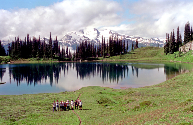
Lyman Lake to Image Lake
Another pretty long day that started out sunny but slowly became more cloudy and colder as the front moved in. The traverse across Miner's Ridge is long and I would probably have gotten more photos if the weather had been better.
enlarge 227KB, 632x1024 104 ka9705a Stats for Day 5
Waypoints (WP) correspond to those shown on the Caltopo Map. Stats include the Elevation; change in Elevation from the previous WP; Up/Down; Cumulative Elevation gain/loss; Distance in miles from previous WP; Cumulative Mileage for the Day; Cumulative Mileage for the Trip/
enlarge 445KB, 1024x668 105 97kickass073 Day 5
Heading up to Cloudy Pass though the fields of lupine along the trail. Cloudy Peak is to the right.
enlarge 220KB, 1024x687 106 97kickass0731s Bill M. on the long traverse up to Cloudy Pass.
enlarge 218KB, 1024x686 107 97kickass0732s Looking back towards Spider Gap, Red & Chiwawa Mountains.
enlarge 295KB, 1024x671 108 97kickass074
Cloudy Pass is one of the premier views of the Cascades (or anywhere) - Lyman Lake and upper Lyman Basin, and Red Mountain. You can see the route coming down from Spider Gap.
enlarge 238KB, 1024x668 109 97kickass075 Taking a break at Cloudy Pass.
enlarge 327KB, 1024x668 110 97kickass076 Descending from Cloudy Pass.
enlarge 256KB, 1024x686 111 97kickass0761s Charlie, Bill M, Bill P, Peter
Sheltering from the rain at the Image Lake camp as we are cooking supper.
enlarge 419KB, 758x1024 112 97 ka Day 6 1 DAY 6
Online Caltopo Map for Day 6 is HERE
Image Lake to Small Creek
After a "sightseeing" (see description for photo 97kickass078) tour around Image Lake we Retraced our route of the Day 5 until we reached the PCT. We followed the PCT down to Miner's Creek and then headed up FS Trail 789 to Buck Cr Pass. After a long day (10+ mi) we settled for a crummy camp at Small Cr.
enlarge 207KB, 573x1024 113 Ka9706a Stats for Day 6
Waypoints (WP) correspond to those shown on the Caltopo Map. Stats include the Elevation; change in Elevation from the previous WP; Up/Down; Cumulative Elevation gain/loss; Distance in miles from previous WP; Cumulative Mileage for the Day; Cumulative Mileage for the Trip/
enlarge 188KB, 1024x686 114 97kickass0762s View of Sunrise on Glacier Peak from our Camp in the early morning
enlarge 403KB, 1024x668 115 97kickass077
Day 6 - our camp at Image Lake. Charlie, Bill P, and Steve enjoying a cup of java with Glacier Peak rising from the mists beyond. The trail between Charlie and Bill leads to the most scenic KYBO in the Cascades.
enlarge 274KB, 1024x687 116 97kickass0802s Eric, Austin, Brian, and Peter
Before we headed out for the day, we dropped our packs and hiked the trail around the lake.
enlarge 256KB, 1024x674 117 97kickass078 Glacier Peak and Image Lake.
Hiking around the lake we saw a guy "skinny dipping" on the other side of the lake. As we got closer, Somebody exclaimed, "Hey, that guy is not a guy!". Sure enough as we came up to where the swimmer was sitting, we came upon another Holden Village coed enjoying a morning swim, sitting there with her hands strategically placed. As we walked by, Bill P. asked her how the water was. They exchanged a few comments with everyone trying to look like they weren't looking.
If you enlarge the photo to "Original" size, you can see the "skinny dipper" making her way across the lake.
enlarge 221KB, 1024x668 118 97kickass079 Can you find our "Swimmer"?
They say that the view from Image Lake across to Glacier Peak is another one of the best in the Cascades, but I think that we had a bonus that morning.
enlarge 313KB, 1024x668 119 97kickass080 Guys at Image Lake.
enlarge 243KB, 1024x686 120 97kickass0801s Looking back over Image Lake.
enlarge 227KB, 1024x685 121 97kickass0803s Another view of Image Lake and Glacier Peak shrouded in clouds.
enlarge 305KB, 1024x672 122 97kickass081 Bill P - testing the water himself.
enlarge 320KB, 696x1024 123 97kickass082 Eric and Kyle.
enlarge 302KB, 1024x675 124 97kickass083 Andrew - Leaving Image Lake.
The sign in the background marks the trail down to the designated camp for Image Lake (no camping at the lake itself).
enlarge 358KB, 1024x673 125 97kickass084 Charlie on Miner's Ridge heading back to the Cascade Crest Trail.
At the junction with the CCT, we met a group that was on a speed trek. I asked them where they were going, and they said that they were heading the CCT up over Suiattle Pass and then down Agnes Creek. I told them that they should make the short side trips to Image Lake and to Cloudy Pass to get the most spectacular views anywhere. They weren't interested, so I told them that that was like having a hamburger without mayo, onions, and ketchup. I guess they thought I was some kind of wacko, cause they immediately took off up the trail in a cloud of dust.
enlarge 220KB, 1024x676 126 97kickass085
View from Miner's Ridge - the Suiattle river is at the left, and Dusty Creek just left of center.
(Just another note on the "speed" hikers from the previous photo. The CCT used to climb Miner's Ridge with an alternate to Image Lake. The reroute up Miner's Creek avoids the steep climb up Miner's Ridge but replaces it with an easier but much, much, less scenic ascent.)
enlarge 293KB, 1024x674 127 97kickass086 Steve and Charlie - Fortress Mtn as a backdrop.
Usually we filter our water, but where there is little chance that people are camping near the water source, I'll generally drink the water as is. At the beginning of the trip Steve and Charlie were adamant that all their water be filtered, and they would be pumping water when everybody else would be filling their canteens from the stream. I was taken aback along this stretch of the trail, when I came around a bend and both Charlie and Steve were filling their canteens from a stream along the trail!
enlarge 326KB, 1024x668 128 97kickass087
Bill P., Brian, Eric (green pack), Andrew (white hat), Charlie (in mosquito netting). When we got to the CCT we headed south until we got to the junction of the Buck Creek Pass Trail. This photo is taken near where the Buck Cr Pass Trail goes over the ridge, and is looking back across the valley towards Miner's Ridge.
enlarge 269KB, 1024x668 129 97kickass088
Looking back toward Miner's Ridge and Plummer's Mountain that we had hiked a few hours before. It's disheartening to have to drop all the way into the valley and have to gain all that elevation again. When we got to the ridge crest of Middle Ridge, we met "Pink Cheeks" and her companion again. We had planned on going up the ridge to a little basin to camp, but that was where PC and friend were headed so I opted to continue on the trail, which turned out to be a bad decision in that we had to camp in a crappy camp at Small Creek instead of high up in the meadows. Basically we were pitching our tents in the trail - no one was happy that night.
enlarge 373KB, 644x1024 130 97 ka Day 7 1 DAY 7
Online Caltopo Map for Day 7 is HERE
Small Creek to Buck Creek Pass
The benefit of making it to Small Cr to camp was that it was less than 1.5 mi to our camp at Buck Cr Pass. After we set up camp we did a long day hike along the High Pass trail.
enlarge 216KB, 1024x855 131 ka9707 Stats for Day 7
Waypoints (WP) correspond to those shown on the Caltopo Map. Stats include the Elevation; change in Elevation from the previous WP; Up/Down; Cumulative Elevation gain/loss; Distance in miles from previous WP; Cumulative Mileage for the Day; Cumulative Mileage for the Trip/
The climb out of Small Creek is short but steep. I put Brian in front as hikemaster, but had to fire him as he was going much too fast. Also, enlarge the photo and look at Charlie's hiking stick. Then go back and look at the photos from the beginning of the hike - it looks like it has gotten shorter by about 3 feet!
enlarge 297KB, 1024x675 133 97kickass090
As we head along the trail down into Buck Creek Pass, Glacier Peak comes into view from behind Flower Dome. Note the cloud over Glacier Peak.
enlarge 276KB, 1024x673 134 97kickass091 Full on view of Glacier Peak.
enlarge 259KB, 1024x686 135 97kickass0911s
After setting up camp at Buck Cr Pass, we took a day hike up the trail towards High Pass. Here we are climbing up Liberty Cap above Buck Cr. Pass. Helmet Butte is to the left with Fortress Mtn. just to the its right.
enlarge 357KB, 1024x668 136 97kickass092
This trail was once supposed to be part of the Cascade Crest Trail, but it never was constructed over High Pass. Mountain to the left is Fortress Mtn.
enlarge 447KB, 1024x668 137 97kickass093 Charlie, Steve, and Bill P. heading up the trail that goes around the side of Liberty Cap.
enlarge 301KB, 1024x668 138 97kickass094 Taking a break with a great view of Glacier Peak.
enlarge 330KB, 1024x668 139 97kickass095 Another view - this is a beautiful stretch of trail.
enlarge 244KB, 1024x686 140 97kickass0951s Another view.
enlarge 226KB, 1024x686 141 97kickass0952s
Typical ridge walking on the way to High Pass - view is down Buck Creek Valley.
enlarge 219KB, 1024x686 142 97kickass0953s Eric and Kyle.
enlarge 202KB, 1024x686 143 97kickass0961s
Austin, Kyle, Eric, Chip, Peter, and Bill - taking a break on the way back to camp.
enlarge 270KB, 1024x670 144 97kickass096 Eric, Chip, Peter, and Andrew -
After rounding Liberty Cap, the trail goes along the ridge for a while and then goes over to the north side of the ridge and traverses across the steep slopes of peak 7276. The trail here is in pretty bad condition, and the dropoff makes you a little nervous. I went around a corner and saw that the guys were crossing a steep snowfield that was over the trail and a slip would be a one way ticket to Eternity. I stopped the rest from going over and was relieved that those that had already crossed go back over safely. We headed back to this spot on the ridge and took a break.
The guys were a little nonchalant about crossing the snowfield, and Steve gave them quite a tongue lashing. Later, Chip stated that he hadn't seen Steve that pissed since someone dropped a book in the Martha Lake Library.
enlarge 263KB, 1024x668 145 97kickass097
Looking across Buck Creek we can see in the distance our route at the beginning of the trip - from Carne Mountain at right to Mt Maude at the left. (See Google Earth photo HERE for help identifying peaks.)
enlarge 285KB, 1024x669 146 97kickass098
Looking towards Mt. Maude - The route of the Massie Lake HR traverses this ridge.
enlarge 276KB, 1024x675 147 97kickass099 Bill and Andrew - this is where the trail goes over to the north side of the ridge.
enlarge 286KB, 1024x668 148 97kickass100 View looking south from the trail.
Heading back to Buck Creek Pass near where the trail starts to descend around Liberty Cap.
enlarge 423KB, 1024x677 150 97kickass102
Heading down to Buck Creek Pass - Helmet Butte and Fortress Mtn. as the backdrops.
enlarge 274KB, 1024x687 151 97kickass103s Our last camp - Buck Cr. Pass: Eric, Charlie, Chip, Andrew, Austin, and Brian.
enlarge 253KB, 1024x686 152 97kickass104s Last Camp.
enlarge 520KB, 1024x970 153 97 ka Day 8 1 DAY 8
Online Caltopo Map for Day 8 is HERE
Buck Cr Pass to Trinity Trailhead
The last day was the longest but everyone only had one thought - that burger at the 59'r Diner!
enlarge 197KB, 1024x819 154 ka9708 Stats for Day 8
Waypoints (WP) correspond to those shown on the Caltopo Map. Stats include the Elevation; change in Elevation from the previous WP; Up/Down; Cumulative Elevation gain/loss; Distance in miles from previous WP; Cumulative Mileage for the Day; Cumulative Mileage for the Trip/