From Kitchen Canyon to Cottonwood Wash.
Battling icy river crossings to Old Pareah townsite and through the "Box" of the Paria to trails end at Cottonwood Wash.
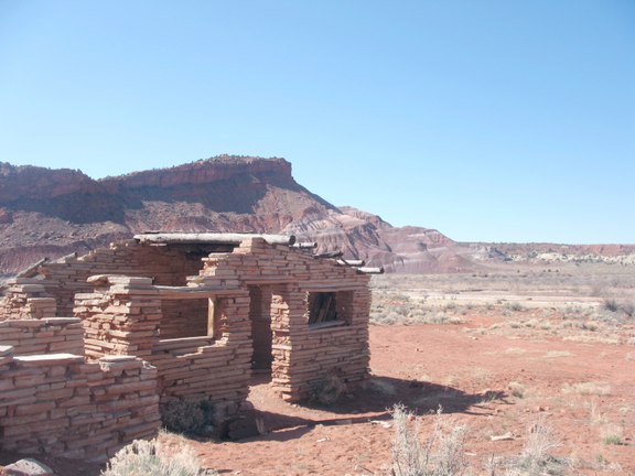
Ruin at Old Paria Town Site
Photos titles ending in "b" are by Bill; in "a" by Allison; in "r" by Ryan; and, in "k" by Kristina.
Troop 24 Kickass Trekkers: "The High Adventure Troop" Alumni Backpacking Trip
-Cascade Bill Mooseker
Date(s): March 27, 2009. Album by Cascade Bill. Photos by WHM/ Ryan/Kristina/Allison. 1 - 62 of 62 Total. 1075 Visits.
enlarge 208KB, 800x549 1 pics 1
If you want to save photos to your computer, click the box under the thumbnails of the photos you want to download. Then click the "Download" button at the top of the album. Pick the size you'd like to download (Original is best)and the photos will be downloaded to a folder of your choice.
enlarge 114KB, 800x600 2 ut09-d4-001r View of the cliff at the mouth of Kitchen Canyon on a very cold morning.
enlarge 126KB, 600x800 3 ut09-d4-002k On quite possibly the coldest morning of my backpacking career, we climbed out of our warm sleeping bags. Only a few of us wanted to bother with breakfast, and the guys who were going to do the car shuttle headed out as soon as they had their gear packed. Getting on our way we found that Kitchen Creek was completely frozen.
enlarge 167KB, 600x800 4 ut09-d4-003a The sand was like concrete and it looked like the creek had been flash frozen.
enlarge 95KB, 600x800 5 ut09-d4-004a The sun wasn't doing much to cut the cold.
enlarge 99KB, 600x800 6 ut09-d4-005k Ryan making his way down Kitchen creek's icey path.
enlarge 99KB, 600x800 7 ut09-d4-006b Looking back towards the cliff that we had camped below.
enlarge 115KB, 600x800 8 ut09-d4-007r Kitchen Creek - almost to the Paria.
enlarge 107KB, 600x800 9 ut09-d4-008k View of the ice and frozen sand in Kitchen Creek.
enlarge 91KB, 800x600 10 ut09-d4-009r The last bend in Kitchen Creek before joining the Paria. You can see we are almost to the side canyon we had checked for a campsite the day before.
enlarge 86KB, 800x600 11 ut09-d4-010k On the Paria - it was pretty icey as well.
enlarge 82KB, 800x600 12 ut09-d4-011k Ryan crossing the Paria. Note that the canyon is opening up beyond.
enlarge 125KB, 800x600 13 ut09-d4-012r More Ice.
enlarge 98KB, 800x600 14 ut09-d4-013r Although the main river wasn't completely frozen it was like a 7-11 slushy - you can see the ice crystals in the water. It was excruciating to cross, and we had to do it many times.
enlarge 116KB, 600x800 15 ut09-d4-014r Kristina making a crossing - you can see all the ice crystals in the water.
enlarge 169KB, 600x800 16 ut09-d4-015r Ryan got this shot of the ice remaining on his feet after a crossing.
enlarge 87KB, 800x600 17 ut09-d4-016b Eric and Danny - coming out of the shadow into the sunlight, not that it was much comfort.
enlarge 111KB, 800x600 18 ut09-d4-017b Eric and Danny, with Allison on the other side of the river. Eric and Danny had a strategy of climbing over everything in order to not cross the river if they could avoid it.
enlarge 88KB, 800x600 19 ut09-d4-018b Bill - Looking back up canyon. Below here the canyon widened considerably.
enlarge 87KB, 800x600 20 ut09-d4-019b Man it's cold.
enlarge 115KB, 800x600 21 ut09-d4-020a Allison caught up to me just as we reached the end of the Red Rock Cliff that I call the Ship's Prow. I took this picture of her with her camera.
enlarge 95KB, 800x600 22 ut09-d4-021a Allison got this picture of me. - you can see that the geology has changed - it's more of a painted desert, with rounded hills instead of the sharp rocky buttresses from upcanyon.
enlarge 128KB, 800x600 23 ut09-d4-022a The last of the red cliffs on top of the more rounded strata.
enlarge 114KB, 800x600 24 ut09-d4-023a Another view of the lforks that look like a layered mousse pudding.
enlarge 91KB, 800x600 25 ut09-d4-024a A close up - you can see the red rock cliffs above.
enlarge 140KB, 800x600 26 ut09-d4-025a The red cliff I call the ships prow (Point 5688 on the topo) is a landmark that is visible for a long ways down the canyon.
enlarge 162KB, 800x600 27 ut09-d4-026r Kristina crossing a bench as the river meanders through the valley - its hard to find the best way along this stretch. Do you follow the river with its long meanders or try a shortcut through the brush?
enlarge 117KB, 800x600 28 ut09-d4-027r Kristina - after crossing the river. You can see the "Ships Prow" behind her.
enlarge 127KB, 800x600 29 ut09-d4-028r Calico Peak - a prominent landmark is on the west side of the valley.
enlarge 138KB, 800x600 30 ut09-d4-029a Another shot of Calico Peak (butte).
enlarge 113KB, 800x600 31 ut09-d4-030k Further on down the valley we come upon an actual road - you can drive to here with a high clearance vehicle.
enlarge 62KB, 900x506 32 ut09-d4-032k The valley narrows at the end and goes through the "Box of the Paria".
enlarge 86KB, 900x506 33 ut09-d4-035k Looking back up the canyon - you can see the "Ships Prow" at the left.
enlarge 148KB, 600x800 34 ut09-d4-036b Just before entering the Box you see this rustic ruin at the Old Pareah town site.
enlarge 172KB, 800x600 35 ut09-d4-037b Close up of old homestead.
enlarge 90KB, 800x600 36 ut09-d4-038b Looking back across the valley with the ruin in the foreground.
enlarge 97KB, 800x600 37 ut09-d4-039a Eric inside the old building.
enlarge 146KB, 800x600 38 ut09-d4-041a Allison at old ruin.
enlarge 189KB, 800x600 39 ut09-d4-043a Allison
enlarge 92KB, 800x600 40 ut09-d4-044a Allison and Eric.
enlarge 88KB, 800x600 41 ut09-d4-045b Eric and Allison heading down canyon.
enlarge 109KB, 600x800 42 ut09-d4-046a Entering the "Box"
enlarge 96KB, 800x600 43 ut09-d4-048a Looking back at the wide Paria canyon from the entrance to the "Box".
enlarge 102KB, 600x800 44 ut09-d4-049a The Paria channeling its way through the Box.
enlarge 121KB, 600x800 45 ut09-d9-002b Danny and Eric found a strange ruin on the canyon wall - it's behind them with all the small holes.
enlarge 90KB, 600x800 46 ut09-d9-004b Zoom in on this (chose original size) and you can see that the construction appears to use sawn lumber rather than sticks. What was it's purpose? Who built it" When was it built? Was it part of a movie set? Were those holes supposed to be hand and foot holes? Who Knows???
enlarge 132KB, 800x600 47 ut09-d9-003b Update 2017 - Apparently the ruin is a remnant that was built for the movie Mackenna's Gold (1969) starring Gregory Peck, Telly Savalas, and Omar Sharif. A clip of the movie can be found HERE Thanks to Zach Alan of the Facebook group: Grand Staircase Escalante National Monument and Adjacent
enlarge 36.17MB, 800x600 48 Paria River crossing Danny & Eric.mp4 VIDEO - Click Photo to View For highest quality, click the "Download MPEG4" link.
Danny and Eric crossing the Paria near the mystery ruin.
enlarge 108KB, 600x800 49 ut09-d4-050k Going though the Box - we come upon this spike.
enlarge 106KB, 600x800 50 ut09-d4-051a Looking back at the spike.
enlarge 98KB, 800x600 51 ut09-d4-052k High sandy banks along this stretch of the Box.
enlarge 92KB, 800x600 52 ut09-d4-053k Ryan - a series of alcoves worn into the rocks.
enlarge 87KB, 800x600 53 ut09-d4-054k Another view.
enlarge 81KB, 800x600 54 ut09-d4-055k Kristina at the alcove.
enlarge 113KB, 800x600 55 ut09-d4-056a Almost through the Box we can see the canyon opening up beyond.
enlarge 107KB, 600x800 56 ut09-d4-057a Just a few more turns of the river to go.
enlarge 121KB, 800x600 57 ut09-d4-058b Eric coming out of the Box.
enlarge 101KB, 800x600 58 ut09-d4-059b Looking back at the Box from the confluence of the Paria with Cottonwood canyon.
enlarge 74KB, 900x506 59 ut09-d4-060k View from the end of our trek while waiting for the car shuttle to arrive.
enlarge 60KB, 900x506 60 ut09-d4-061k Looking back at the Box from the exit trailhead just off of the Cottonwood Canyon road.
enlarge 102KB, 800x600 61 ut09-d4-062k Ryan at the end of the trip.
enlarge 378KB, 900x450 62 next 2.png CLICK HERE for Previous Album CLICK HERE Back to Folder