Day 4: Johnson Lake to Oreamnos Lake
Day 5: Oreamnos Lake to Kelly Lake via abandoned sheep drive high route past Sawed Cabin Lake.
Day 6: Kelly Lake to Middle Fork Trailhead via Bitterroot Pass.
Andrew at Pass Near Sawed Cabin Lake
Photos titles ending in "b" are by Bill; in "r" by Roger; and, in "a" by Andrew.
Troop 24 Kickass Trekkers: "The High Adventure Troop" Alumni Backpacking Trip
-Cascade Bill Mooseker
Date(s): August 2005. Album by Cascade Bill. Photos by Andrew/Roger/Bill. 1 - 122 of 122 Total. 3572 Visits.
enlarge 186KB, 800x608 1 mt05-134rmap4 Day 4: Johnson Lake to Oreamnos Lake Following the spur trail between the Hi Line Tr and the Continental Divide Tr, we then head south on the Continental Divide Trail through forest then more steeply via switchbacks to a meadowed basin below Pintler Pass. After a break we follow the trail to the end of the basin then up more switchbacks to grassy Pintler Pass (Elev 8740' - about 2 mi from Johnson Lake). Dropping down quickly we traverse to the jct of the Oreamnos Lake Trail (High Route). From there it is a short climb to Oreamnos Lake (EL 8363') where we set up camp - 3.2 miles and 1350' total elev gain from Johnson Lake. Note best viewed at "original size".
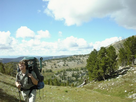
enlarge 173KB, 600x800 2 mt05-135a Andrew on trail to Pintler Pass.
enlarge 128KB, 800x600 3 mt05-136a Entering basin below Pintler Pass (about 1.5 mi from Johnson Lake).
enlarge 128KB, 800x533 5 mt05-138r I'll bet 75 years ago this basin would be filled with sheep.
enlarge 103KB, 800x533 6 mt05-139r Basin.
enlarge 85KB, 600x800 7 mt05-140a Basin
enlarge 73KB, 800x600 8 mt05-141a Pintler Pass - Most of the climb is done but the pass is reached by steep switchbacks at the end of the basin.
enlarge 115KB, 600x800 9 mt05-142a Roger taking a break.
enlarge 153KB, 600x800 10 mt05-143a Andrew - Pintler Pass
enlarge 119KB, 600x800 11 mt05-144a Cascade Bill - only a couple of hundred feet to go.
enlarge 97KB, 600x800 12 mt05-145a View from Pintler Pass (There I am making my way up the final switchbacks) - you can see the trail going through the basin below and Johnson lake far below.
enlarge 103KB, 533x800 13 mt05-147r View of basin and peak 9805 from Pintler Pass.
enlarge 69KB, 800x533 14 mt05-148r Johnson Lake and the Rock Creek Valley from Pintler Pass. Note extent of Forest Fire burn area.
enlarge 71KB, 533x800 15 mt05-149r View from Pintler Pass.
enlarge 126KB, 533x800 16 mt05-150r Shelby taking a break at Pintler Pass (Elev 8738')
enlarge 161KB, 533x800 17 mt05-151r Telephoto view of Rocks from viewpoint above Pintler Pass.
enlarge 82KB, 533x800 18 mt05-152r View from above Pintler Pass.
enlarge 88KB, 533x800 19 mt05-153r Cascade Bill at Pintler Pass. - My boyhood dream was to be a cowboy out west riding over a pass like this but I envisioned myself as Gene Autry, Roy Rogers, or Lash Larue (for you old west 50's version fans) but not as Gabby Hayes.
enlarge 142KB, 800x600 20 mt05-154a The "Other side of the Mountain" - looking towards Oreamnos Lake.
enlarge 71KB, 800x600 21 mt05-155a Our destination - Oeamnos Lake lies below middle ridge to right of center below West Pintler Peak. (zoom photo).
enlarge 84KB, 600x800 22 mt05-156a Andrew's photo from ridge south of Pintler Pass across pass to opposite ridge (Roger went up this one).
enlarge 74KB, 800x600 23 mt05-157a Johnson Lake from ridge above Pintler Pass.
enlarge 92KB, 600x800 24 mt05-158a Johnson Lake.
enlarge 88KB, 800x533 25 mt05-159r Roger's photo of Oreamnos Lake from ridge above Pintler Pass. West Pintler Peak at center of photo.
enlarge 124KB, 800x533 26 mt05-160r Telephoto view of Oreamnos Lake from ridge above Pintler Pass.
enlarge 89KB, 800x533 27 mt05-161r Oreamnos Lake- Our camp was in the grove of trees between the meadow's just below the lake. You can see our high route going up the slope beyond (and to the left) of the lake.
enlarge 91KB, 533x800 28 mt05-162r Oreamnos Lake.
enlarge 50KB, 800x533 29 mt05-163r Looking South from the ridge above Pintler Pass - we had planned to follow the Continental Divide trail which drops from Pintler Pass to about the center of the photo before clinbing up to the top of the middle ridge at the right of the photo.
enlarge 125KB, 533x800 30 mt05-164r Bill, Andrew, and Shelby at Pintler Pass - Andrew went up the opposite ridge for his photos.
enlarge 64KB, 800x600 33 mt05-167a Oreamnos Lake (El 8363) - There were fish in the lake but they weren't biting (skunked again).
enlarge 76KB, 600x800 34 mt05-168a Oreamnos Lake - a pretty gem. We rode out a thunder storm that hit right after we arrived at the lake. Broke out the raingear but the rain while heavy didn't last long.
enlarge 66KB, 600x800 35 mt05-169a Looking at Pintler Pass from our camp at Oreamnos Lake.
enlarge 107KB, 800x533 36 mt05-170r Return of the Pink Flamingo (See Beartooths 2003).
enlarge 124KB, 800x533 37 mt05-171r He can't run but he can hide.
enlarge 81KB, 800x533 38 mt05-172r Documenting the return of the Pink Flamingo.
enlarge 103KB, 800x533 39 mt05-173r It is him!
enlarge 105KB, 800x533 40 mt05-175r Don't let him get away! (pond below Oreamnos Lake).
enlarge 108KB, 800x533 41 mt05-176r He bites!
enlarge 103KB, 800x533 42 mt05-178r Shelby shows his love.
enlarge 58KB, 800x533 43 mt05-179r Roger and an old friend.
enlarge 100KB, 800x533 44 mt05-180r Jumping for Joy!
enlarge 99KB, 800x533 45 mt05-181r Whoopie Kai Yea!
enlarge 60KB, 800x533 46 mt05-182r Choking the Flamingo!
enlarge 144KB, 533x800 47 mt05-183r "To sleep, perchance to dream- ay, there's the rub."
enlarge 49KB, 800x533 48 mt05-184r ... a wild dissolving bliss Over my frame he breathed, approaching near, And bent his eyes of kindling tenderness Near mine, and on my lips impressed a lingering kiss, ~ Percy Bysshe Shelley
enlarge 39KB, 800x533 49 mt05-185r Full Moon and clouds over our camp at Oreamnos Lake.
enlarge 30KB, 533x800 50 mt05-186r The moon was beautiful.
enlarge 33KB, 800x533 51 mt05-187r We weren't the only ones enjoying the moon - that night we were awakened several times by a strange barking near our camp. Didn't sound anything like coyotes - if anyone has any idea what it might have been (note we saw no one that day or for the remainder of our trip so it couldn't have been a dog from another party), please make a comment.
enlarge 69KB, 800x533 52 mt05-188r Andrew and Shelby - watching the moon.
enlarge 186KB, 800x608 53 mt05-134rmap4 Day 5: Oreamnos Lake to Kelly Lake Originally, I had planned to retrace our steps back to the Cont Divide Tr and follow it, but when exploring the basin above Oreamnos Lk, I found vague tread from an old abandoned sheep drive heading over a pass towards Sawed Cabin Lake. We decided to follow this tread - if it panned out, we could save a lot of distance and climbing. Pan out it did and we were able to cut out a couple of miles and about a 1000' feet of climb. Rejoining the Cont. Divide Tr above Sawed Cabin Lake, we followed it to pick up the trail towards Bitterroot Pass to Kelly Lake for Camp 5 (6.3 miles and 1450' of elev gain from Oreamnos Lake). Note best viewed at "original size".
enlarge 93KB, 600x800 54 mt05-189a Heading up the old sheep drive - looking back at Pintler Pass (Oreamnos Lake is to the left -not in pic). You can see me down there putting my fleece in the pack - huffing up a hill raises the temp quite a bit.
enlarge 88KB, 800x600 55 mt05-190a A wider view.
enlarge 108KB, 600x800 56 mt05-191a Top of Hell Hill (straight up - marginal tread) - Lake in background is the small lake above Oreamnos (no fish or not biting there). Low point on Continental Divide to right of lake appears to be an easy pass to drop down to the Hiline Trail near Phyllis Lake.
enlarge 81KB, 533x800 57 mt05-192r Close up of lake above Oreamnos.
enlarge 90KB, 800x533 58 mt05-193r Wider view.
enlarge 135KB, 800x600 59 mt05-194a Andrew at top of Hell Hill.
enlarge 116KB, 800x600 60 mt05-195a Cascade Bill - top of Hell Hill: I was sure breathing hard when I got here. It was almost as steep as Hell Hill in the Payseyton (see 2001 trips). All in all, this was the best day of the year for me - finding another abandoned sheep drive is always the best.
enlarge 103KB, 800x600 61 mt05-196a All semblence of tread disappeared in the meadows on top of Hell Hill. Andrew went over to the notch (left of center) to see if there was a way down from there. He found that the vague tread picked up again on this side of the notch. Abandoned sheep drives such as this usually have no tread in meadows and you have to guess on the best route - 50 to 60 years of only sporadic use also take their toll on any tread that was there as well (See Kick Ass 2 - 2001 trips for the epitomy of an abandoned sheep drive).
enlarge 122KB, 600x800 62 mt05-197a Looking back to the top of Hell Hill from the notch above Sawed Cabin Lake.
enlarge 95KB, 800x600 63 mt05-198a Looking over the notch - Sawed Cabin Lake is behind the hill at the left. The Continental Divide Trail passes near the top of the meadow at the left of the picture.
enlarge 115KB, 600x800 64 mt05-199a Another shot looking back the way we came.
enlarge 91KB, 800x533 65 mt05-200r Top of the notch - and a good view of our route up from Sawed Cabin to hit the C.D. Trail.
enlarge 87KB, 800x600 66 mt05-201a Andrew at Notch.
enlarge 95KB, 533x800 67 mt05-202r Looking westward from the notch.
enlarge 139KB, 600x800 68 mt05-203a Looking down the "Plunge" - if you zoom the picture you can make out Shelby at the bottom of the talus.
enlarge 153KB, 800x600 69 mt05-204a The Plunge - a steep ledge goes up the hill to the notch alongside a rocky cliff. You follow the tread down through the grassy area and then around and through the edge of the talus below.
enlarge 135KB, 533x800 70 mt05-204r Looking back up the "Plunge" - Andrew and Bill above. I wouldn't want to come down here during or after a rain.
enlarge 144KB, 600x800 71 mt05-206a Cascade Bill coming down the Plunge.
enlarge 138KB, 600x800 72 mt05-207a A good view of the Plunge from the bottom - Bill is just easing his way around the talus at the bottom.
enlarge 78KB, 800x533 73 mt05-208r Sawed Cabin Lake from the bottom of the Plunge - we didn't go down to the lake so we don't know the status of campsites. The guidebook says that there are no fish in the lake - it looks pretty shallow from here.
enlarge 81KB, 600x800 74 mt05-209a Looking back up at the Plunge from the meadows of Sawed Cabin Lake - you wouldn't think that there would be a route from this vantage point.
enlarge 95KB, 800x600 75 mt05-211a West Pintler Peak - The Plunge.
enlarge 106KB, 600x800 76 mt05-212a Another view of West Pintler Peak - very impressive from this viewpoint as compared to those from the east and west.
enlarge 159KB, 800x533 77 mt05-213r The "Sawed Cabin" from which the lake gets its name.
enlarge 123KB, 800x533 78 mt05-214r Close up of the Sawed Cabin construction.
enlarge 114KB, 800x533 79 mt05-215r Roger - taking a break at the top of the hill where our high route ended at the Continental Divide Trail - you can see from the tread that this trail unlike the Pacific Crest or John Muir Trail doesn't get Mega traffic.
enlarge 84KB, 800x533 80 mt05-216r Roger - The clouds and wind picked up when we took our break - Brrrrr!, no more tee shirts, break out the fleece!
enlarge 149KB, 800x533 81 mt05-217r Heading west, the Continental Divide trail traverses with minor ups and downs with views south (we even spied farms and a highway in the far distance). After a while we enter another burn area for Not Much Fun Hiking.
enlarge 125KB, 800x533 82 mt05-220r At the junction with the Bitterroot Pass Trail, we can see the Continental Divide Trail heading west through the burn area - note that the mountains that way are less rugged than those we've passed through.
enlarge 155KB, 800x533 83 mt05-221r Shelby and Andrew checking the map at the Junction of the Continental Divide Trail and the Bitterroot Pass Trail - here the Bitterroot Pass Trail takes a turn to the north through the burn area (which is quite extensive and extends along the trail to just before the hill up to Kelly Lake).
enlarge 108KB, 800x533 84 mt05-222r Sign at Bitterroot Pass/Continental Divide Trail Juction - Trail 313 is also know as the "Sapphire Crest Trail" but after walking it, the section from here to Kelly Lake would be more aptly named, the "Charcoal Crest".
enlarge 90KB, 800x600 85 mt05-223a Kelly Lake - it sure was a relief to get out of the burn area.
enlarge 78KB, 800x600 86 mt05-224a Kelly Lake
enlarge 89KB, 600x800 87 mt05-226a Kelly Lake - no fish but with beautiful meadows all around the lake.
enlarge 148KB, 533x800 89 mt05-228r Shelby - I've heard of "half assed" but "half pants" is a new one.
enlarge 144KB, 533x800 90 mt05-230r Always time for a little fun.
enlarge 132KB, 800x533 91 mt05-231r Roger at our camp in the meadow at Kelly Lake.
enlarge 110KB, 800x533 92 mt05-232r Andrew - we had a nice afternoon and evening at our camp at Kelly Lake.
enlarge 133KB, 800x600 93 mt05-233a A Sunset Dinner at Kelly Lake.
enlarge 69KB, 800x600 94 mt05-234a Dusk Falls - we hoped to see moose but no dice.
enlarge 153KB, 800x533 95 mt05-235r Shoreline of Kelly Lake - lots of frogs and leeches.
enlarge 96KB, 800x533 96 mt05-236r Far away from the hustle and bustle - Kelly Lake.
enlarge 102KB, 800x533 97 mt05-237r Shelby on far side of the lake - the trail goes round the right side of the lake.
enlarge 98KB, 800x533 98 mt05-238r Looking across the lake from near our camp. Bitterroot Pass is off to the right out of this picture and was not really visible from our camp.
enlarge 63KB, 800x533 99 mt05-239r Alpenglow over Kelly Lake - looking east. West Pintler Peak is at the left (Sawed Cabin Lake is over the pass to the right of W.P. peak)
enlarge 54KB, 800x533 100 mt05-240r Another shot of Alpenglow over Kelly Lake.
enlarge 42KB, 800x533 101 mt05-241r Clouds catching the setting sun.
enlarge 29KB, 800x533 102 mt05-242r More Clouds.
enlarge 112KB, 800x533 103 mt05-243r Lakeshore - Kelly Lake - Roger's art photo with very nice composition.
enlarge 101KB, 800x533 106 mt05-246r Our camp from across the lake - that's me in the red hat.
enlarge 57KB, 600x800 107 mt05-247a Sunset - Lake and clouds.
enlarge 50KB, 800x533 108 mt05-248r Reflections.
enlarge 42KB, 533x800 109 mt05-249r More Reflections.
enlarge 126KB, 418x800 110 mt05-249rmap5 Map Day 6: Kelly Lake to Middle Fork Trailhead The climb to Bitterroot Pass from Kelly Lake is not far (a little less than a mile and about 400' climb) but there is a maddening false summit near the top where you think that you're there but then you start going up again. Over the top and down to Little Johnson Lake (1.4 mi) . Then a minor up to a shoulder then dropping to a basin, crossing to another shoulder then dropping down to a major meadow (nice camp - we had intended to stay here for Camp 6 after staying at Hidden Lake for Camp 5, but we opted to get out a day early. At the end of the meadow is the junction with the Middle Fork trail (2.5 mi from Kelly Lk). From there it's 4.1 miles of valley pounding to the trailhead.
enlarge 78KB, 800x533 111 mt05-250r When we rolled out of our sleeping bags, it was still dark and everything was covered with a thick layer of frost. Because of our long hike we fixed our oatmeal breakfast while packing up and were on our way before the sun was over the ridge. Roger got this shot of the mist over the lake before we left.
enlarge 37KB, 800x533 112 mt05-251r View from Bitterroot Pass - the trailhead is down there in the trees somewhere.
enlarge 36KB, 800x533 113 mt05-252r Another view from Bitterroot Pass.
enlarge 32KB, 800x533 114 mt05-253r Telephoto view from Bitterroot Pass.
enlarge 70KB, 800x533 115 mt05-254r Mist on Little Johnson Lake - The guys were waiting for me here.
enlarge 68KB, 533x800 116 mt05-255r Shelby at Little Johnson Lake.
enlarge 58KB, 533x800 117 mt05-256r Mist at Little Johnson Lake.
enlarge 84KB, 533x800 118 mt05-257r Sunrise at Little Johnson Lake.
enlarge 46KB, 533x800 119 mt05-258r There are no fish in Little Johnson Lake.
enlarge 86KB, 800x533 120 mt05-259r Aster at Little Johnson Lake.
enlarge 51KB, 800x533 121 mt05-260r Can't find a name for this flower (looked in 3 guidebooks) it kinda reminds me of an onion, but none of the wild onions listed in the book looked quite like this one. If anyone knows the name, please add a comment.
enlarge 43KB, 800x533 122 mt05-261r Morning dew on Lupine at Little Johnson Lake.