 Tasmania #06 Collage Tasmania #06 Collage
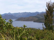
|  Panorama Lake Pedder Panorama Lake Pedder
Lake Pedder was created by the construction of a large rockfill dam on the upper reaches of the Huon River at Scotts Peak and another on the Serpentine River above its junction with the Gordon. A small dam was also constructed across a low marshy area at Lake Edgar, near Scotts Peak, thus flooding the Original Lake Pedder and all its natural beauty.
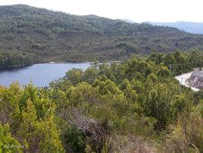
|  Lake Pedder Lake Pedder
The Man-made Lake Pedder has a surface area of 242 square kilometres and a total volume of 3.3 cubic kilolitres. Variation in the level of Lake Pedder is limited to 1.5 metres. This enhances its popularity as a venue for fishermen and tourists.
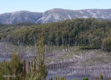
|  Lake Pedder Lake Pedder
The wild beauty of the original Lake Pedder and its surrounds was formed 10,000 years ago, at the end of the last ice age. There was a wall of mountains, guarding what's called a glacial outwash lake, with high dunes and a beach of fine pink quartz sand.
|
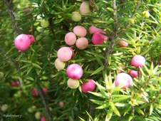 Mountain Berry (Cyathodes) Mountain Berry (Cyathodes)
Endemic to Tasmania
|  Snow Berry (Gaultheria hispida) Snow Berry (Gaultheria hispida)
At Lake Pedder
|  Lake Pedder Lake Pedder
Campaign to restore Lake Pedder in the heart of the Tasmanian wilderness World Heritage Area. In 1972 the flooding of Lake Pedder for a minor hydro-electric scheme created an international environmental furore. Though Tasmania's authorities cling to the age of large engineering works, there are renewed calls for the waters to be drained to restore Lake Pedder to its natural splendor.
|  Native Plum (Cenarrhenes nitida) Native Plum (Cenarrhenes nitida)
At Lake Pedder
|
 Lake Pedder Lake Pedder
Some Tasmanians believe that Lake Pedder might again see the light of day. In 1996, a Federal Enquiry confirmed it was scientifically possible for Pedder to be restored - but money, and perhaps the political will to proceed, are short.
|  Lake Pedder Lake Pedder
Lake Pedder provides about 41 percent of the water used in the Gordon Power Station. Water from the lake flows via McPartlan Canal into Lake Gordon.
|  Gordon Road Gordon Road
The Gordon Road was built during the 1960's to access the construction sites of the Gordon River Power Developement.
|  Golden Rosemary ((Oxylobium ellipticum) Golden Rosemary ((Oxylobium ellipticum)
|
 Lake Gordon Lake Gordon
The Gordon River scheme has created the largest water storage in Australia. This is a region of very high rainfall with an average of 2450mm falling in the development's catchment area every year. Snowmelt from surrounding mountains also replenishes the storages each spring.
|  Lake Gordon Lake Gordon
Lake Gordon from roadside. Low water level shows wasted timber lost though hastily flooding the valley before it could be logged.
|  Lake Gordon Lake Gordon
Lake Gordon from roadside - zoomed in to show low water level revealing wasted timber lost because the valley was hastily flooded before it could be logged. Some call it Progress, others call it Man-made Destruction.
|  Gordon Dam Gordon Dam
Lake Gordon was created by the building of a 140 metre high concrete arch dam across the Gordon River above its junction with the Serpentine River. Water from Lake Gordon and Lake Pedder is used in the underground Gordon Power Station situated near the Gordon Dam.
|
 Gordon Dam Gordon Dam
Lake Gordon has a surface area of 272 square kilometres and total volume of 11.9 cubic kilolitres. It represents 35 percent of the Tasmania's total energy storage capacity.
|  Gordon Dam Gordon Dam
Water from Lake Gordon drops through an intake tunnel to the Gordon Power Station, 183 metres underground before rejoining the Gordon River downstream of the dam.
|  Gordon Dam information Gordon Dam information
Height 140 metres; Length of Crest 198 metres; Thickness at Base 17.7 metres; Thickness at Crest 2.8 metres; Volume of Concrete 154,000 cubic metres; Volume of Water at full capacity 12,450 million cubic metres.
|  Gordon Dam Gordon Dam
From Gordon Dam site showing low water level and towering cliffs rising above lake.
|
 Lake Gordon Lake Gordon
Lake Gordon from Gordon Dam site, zoomed in to show the low water level revealing the waste of timber because the valley was hastily flooded before logging could take place.
|  Quartz Cliffs Quartz Cliffs
Towering Quartz Cliffs rise above the Gordon Dam.
|  Tall Trees Walk Tall Trees Walk
Returned to Mt Field National Park for the Tall Trees Walk.
|  Swamp Gums Swamp Gums
Swamp Gums (Eucalyptus regnans) in Mt Field National Park.
|
 Tall Trees Walk, Mt Field National Park Tall Trees Walk, Mt Field National Park
| 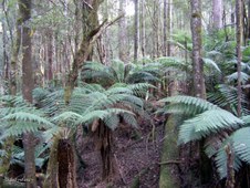 Tree Ferns Tree Ferns
Mt Field National Park.
|  Tall Trees Walk, Mt Field National Park Tall Trees Walk, Mt Field National Park
|  Mt Field's Tallest Mt Field's Tallest
Tasmania's Swamp Gum (Eucalyptus regnans) is the tallest Hardwood and the tallest Flowering Plant in the World. The tallest recorded in Tasmania was 98 m high.
|
 Tall at 79 metres Tall at 79 metres
This Swamp Gum is around 79 m tall and still growing. The top is occasionally pruned by the wind.
| 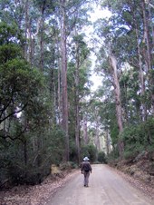 Tall Trees Walk at Mt Field National Park Tall Trees Walk at Mt Field National Park
|  Misty Harbour Misty Harbour
Misty rain at Kettering while waiting to board the Ferry to Bruny Island.
|  Seagulls and Shags at Kettering Seagulls and Shags at Kettering
|
 Leaving Kettering Leaving Kettering
On board the Ferry from Kettering to Roberts Point, Bruny Island.
|  Kettering hillside from Ferry Kettering hillside from Ferry
|  McCrackens Gully on Bruny Island McCrackens Gully on Bruny Island
|  Birdwatchers Birdwatchers
Searching for the elusive Forty-Spotted Pardalote which is endemic to Tasmania and reliant on one species of Eucalypt for survival.
|
 Private Forest Reserve Private Forest Reserve
McCrackens Gully which contains White Gum (Eucalyptus viminalis) which is crucial to the survival of the Forty-Spotted Pardalote.
|  McCrackens Gully McCrackens Gully
More than half of the original White Gum forest and woodland has been cleared thus reducing the habitat of the Forty-Spotted Pardalote.
|  Lacking Sunshine on the McCrackens Gully road Lacking Sunshine on the McCrackens Gully road
|  Coast of Bruny Island Coast of Bruny Island
|
