 Tasmania #5 Collage Tasmania #5 Collage
|  Tessellated Pavement Tessellated Pavement
The Tessellated Pavement in the Tasman National Park is an unusual geological formation, which gives the rocks the effect of being rather neatly tiled.
|  Tessellated Pavement Tessellated Pavement
The pavement appears tessellated (it's tiled) because the rocks forming it were fractured by earth movements.
|  Tessellated Pavement Tessellated Pavement
The flatness of the pavement is due to initial erosion by waves carrying sand and gravel and nearer to the cliff, to chemical action by sea water.
|
 Pittosporum bicolor Pittosporum bicolor
Pittosporum means Pitch Fruit referring to the bitter-tasting sticky seeds which may be seen after the capsule opens.
|  Pirates Bay Pirates Bay
The Tessellated Pavement area of Pirates Bay.
|  Tall Eucalypts at the car park Tall Eucalypts at the car park
|  Towering Trees Towering Trees
|
 Pirates Bay Pirates Bay
|  Martin Cash Memorial Martin Cash Memorial
Memorial to mark the Centenary of the Death of Martin Cash. He was known as a Gentleman Bushranger because he never used Violence. He received a Pardon and died a Free Man on 27 Aug 1877.
|  Tasman Arch Tasman Arch
|  Eucalypt Buds Eucalypt Buds
|
 Eucalypt Bark Eucalypt Bark
|  Tasman Sea Tasman Sea
Rugged Coast joining the Tasman Sea on east coast of Tasmania.
|  Devil's Kitchen 60 m deep Devil's Kitchen 60 m deep
|  Looking down into Devil's Kitchen Looking down into Devil's Kitchen
|
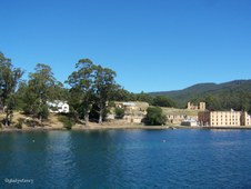
 Port Arthur Port Arthur
Panorama of the Historic Site of Port Arthur on the Tasman Peninsula.
|  Early 1860's Early 1860's
View of Settlement Hill across Mason Cove, early 1860s. The large building in the foreground is the Penitentiary, with the Commissariat Stores on the waterfront to the left. Visible at the top left of the photograph is the semaphore.
|  Ferry Terminal Ferry Terminal
Departure point for Harbour Cruises to Point Puer and Isle of the Dead.
|  Port Arthur Cruises Port Arthur Cruises
|
 Port Arthur viewed from Ferry Port Arthur viewed from Ferry
|  Dockyards Dockyards
Between 1834 and 1848 Port Arthur was home to an industrious shipbuilding enterprise that saw 15 large timber vessels, and over 140 smaller boats, built at the dockyard.
|  Australian Red Ensign Australian Red Ensign
The Australian Red Ensign - Merchant Navy, as for the Australian flag, but with a red field with white stars. Proclaimed in the Flags Act 1953. Covers Australian registered ships under section 30 of the Shipping Registration Act 1981.
|  Dockyards viewed from Ferry Dockyards viewed from Ferry
Clerk of Works House on Left, and Shipwrights House on Right, with Lime Kiln in foreground.
|
 Jetty at Point Puer Jetty at Point Puer
3,000 boys ranging in age from 9 to 18 passed through Point Puer Boys' Prison from 1834-49. It was the first reformatory built exclusively for juvenile male convicts in the British Empire and was renowned for its regime of stern discipline and harsh punishment.
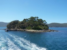
|  Isle of the Dead Isle of the Dead
The Isle of the Dead is a small island located in the harbour adjacent to the Port Arthur Historic Site. Originally called Opossum Island, it was selected as a burial place by the Reverend John Manton in 1833.
|  Isle of the Dead Isle of the Dead
Between 1833 and 1877, about one thousand burials took place on the island. The majority were convicts and ex-convict paupers who were buried mostly in unmarked graves on the lower part of the island. The graves of free people were located on the high side of the island and were sometimes marked by elaborate headstones cut by the convict stonemasons.
|  Port Arthur viewed from returning Ferry Port Arthur viewed from returning Ferry
|
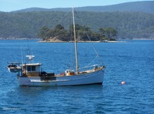 Fishing Boat at anchor in Mason Cove Fishing Boat at anchor in Mason Cove
|  Port Arthur from Jetty Port Arthur from Jetty
|  Tasmanian Blue Gums Tasmanian Blue Gums
An avenue of Tasmanian Blue Gums (Eucalyptus globulus) line the road to the Dockyards at Port Arthur.
|  Lime Kiln Lime Kiln
|
 Lime Kiln Lime Kiln
Historic Lime Kiln built in the Dockyard area of Port Arthur in 1854.
|  Belladonna Lilies at the Dockyards Belladonna Lilies at the Dockyards
|  Eucalyptus globulus Eucalyptus globulus
Tasmanian Blue Gum timber quickly established a reputation with early settlers for its toughness and durability. Its timber is stronger and denser than other similar types of gum tree and is suitable for ship building and similar uses.
|  Younger Blue Gums Younger Blue Gums
Near Port Arthur Dockyards.
|
 Young Tree Young Tree
Young Tasmanian Blue Gum shows a mix of blue juvenile leaves on lower half and mature green leaves on upper half.
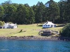
|  Government Gardens Government Gardens
A distinct precinct of the Port Arthur Historic Site, containing a historically comprised landscape and built features, plant materials and other elements of high significance. The gardens were originally established in the late 1830's as an outdoor leisure space for the civil and military officials at Port Arthur, and survived until well after the closure of the settlement in 1877.
|  Government Gardens Government Gardens
The elements of Government Gardens display deliberate design and arrangements reflecting the order and hierarchy of the military and convict occupation of the Historic Site. The Government Cottage Gardens, as well as the Commandant's Garden, are the only two formal gardens within the present Historic Site dating from the convict period reflecting various aspects of civic life.
|  Oyster Plant Oyster Plant
The Government Gardens were reconstructed in accordance with an 1858 survey. Extensive research of historic photographs, palynological soil analysis and archaeological investigations were used to establish the planting species, the type and location of paths, fences and other landscape features originally extant within the precinct. The central pathway, fountain and plantings from the original 1840s were retained.
|
