 Gairdner River looking Downstream Gairdner River looking Downstream
The Gairdner River flows through the pristine Fitzgerald River National Park to the Southern Ocean.
|  Gairdner River looking Upstream Gairdner River looking Upstream
The Gairdner River is popular for Canoeing and provides a pleasant flatwater paddle.
|  Gairdner River Gairdner River
Upstream View of the Gairdner River.
|  Gairdner River Gairdner River
Downstream View of the Gairdner River.
|
 River Bank River Bank
On the Bank of the Gairdner River.
|  Parting view of the Gairdner River Parting view of the Gairdner River
Upstream view of the Gairdner River.
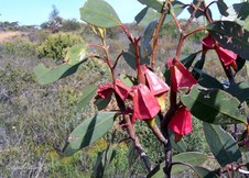
|  Four-Winged Mallee Four-Winged Mallee
Young Four-Winged Mallee (Eucalyptus tetraptera).
|  Four-Winged Mallee Flower Four-Winged Mallee Flower
The opening Flower of the Eucalyptus tetraptera.
|
 Flowers Four-Winged Mallee Flowers Four-Winged Mallee
Flower Buds of the Eucalyptus tetraptera.
|  Grevillea nudiflora Grevillea nudiflora
One of many species of Grevillea.
|  Toothbrush Grevillea Toothbrush Grevillea
Unusual Grevillea with Toothbrush-shaped Flower.
|  Toothbrush Grevillea Toothbrush Grevillea
Side view showing Toothbrush-shape of flower.
|
 Far Horizons Far Horizons
View across Southern Mallee Shrublands towards farming land of Jerramungup.
| 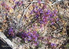 Posy Starflower (Calytrix leschenaultii) Posy Starflower (Calytrix leschenaultii)
|  Pink Myrtle Pink Myrtle
|  Vegetation beside the Road Vegetation beside the Road
Southern Mallee Shrublands.
|
 Fitzgerald Biosphere Fitzgerald Biosphere
A Biosphere reserve is an area dedicated to exploring how people and nature can flourish together.
|  Caterpillar Tractor Caterpillar Tractor
This Caperpillar Tractor now rests at Jerramungup after being used to clear the land for farming.
|  Clawflower Clawflower
Colourful Clawflower at Jerramungup.
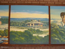
|  Jerramungup Story 1 Jerramungup Story 1
Mural depicting the History of Jerramungup. The first inhabitants were the Aborigines.
|
 Jerramungup Story 2 Jerramungup Story 2
Early Explorers Sailed around the Coastline.
|  Jerramungup Story 3 Jerramungup Story 3
Following exploration by John Septimus Roe, graziers arrived with flocks of Sheep.
|  Jerramungup Story 4 Jerramungup Story 4
Further exploration took place in the Gairdner River area.
|  Jerramungup Story 5 Jerramungup Story 5
The Hassell Homestead was built of stone in 1859 by the Hassell Family.
|
 Jerramungup Story 6 Jerramungup Story 6
The second Hassell Homestead was built in the late 1800's, about 6km from where the town of Jerramungup now stands.
|  Jerramungup Story 7 Jerramungup Story 7
In 1953 under the War Service Land Settlement Scheme, 133 farms were created and ex-servicemen who had completed war service became soldier settlers.
|  Jerramungup Story 8 Jerramungup Story 8
The unique and Internationally recognised Fitzgerald River National Park represents 48% of the Biosphere.
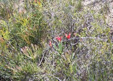
|  Colourful Pea Flowers Colourful Pea Flowers
Flowering brightly in Jerramungup.
|
 Flower Buds of Yate Flower Buds of Yate
Long-fingered flower buds of this Jerramungup Eucalypt.
|  Buds and Seed Cones Buds and Seed Cones
Long-fingered flower bud and spikey seed cones of Jerramungup Yate.
|  Jerramungup Farmlands Jerramungup Farmlands
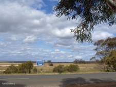
Explorer John Septimus Roe first used the name Jerramungup to refer to the area.
|  Zoomed to Farmlands Zoomed to Farmlands
The Wheat and Sheep Farming Shire of Jerramungup is located 429km SE of Perth.
|
 Jerramungup Road Jerramungup Road
|  Rural View at Jerramungup Rural View at Jerramungup
|  Tall Trees at Jerramungup Tall Trees at Jerramungup
|  Can you find the Bird? Can you find the Bird?
The Bird was a bonus when I zoomed up to photograph these flowers.
|
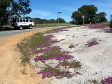 Roadside Colour Roadside Colour
Roadside Colour while travelling between Jerramungup and Dumbleyung with www.wanderer.com.au
|  Round-leaved Pig Face Round-leaved Pig Face
(Disphyma crassifolium).
| 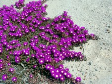 Colour Contrast Colour Contrast
(Disphyma crassifolium).
|  The Road Behind The Road Behind
The road from Jerramungup.
|
