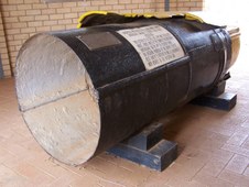
 Damaged Water Pipe Damaged Water Pipe
First stop at Meckering where this 30 inch Water Pipe was damaged in the 1968 Earthquake.
| 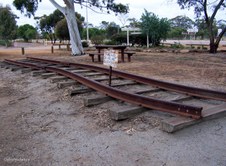 Buckled Railway Line Buckled Railway Line
A section of Standard Gauge Line which was damaged in the Earthquake.
|  Meckering Earthquake Damage Meckering Earthquake Damage
|  Meckering Earthquake Meckering Earthquake
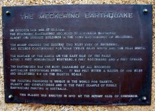
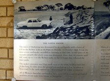
On 14 Oct 1968 at 10.59am the strongest Earthquake recorded in Australia destroyed almost 100 buildings in the town and district of Meckering. It was felt in a radius of 450 miles and registered 6.9 on the Richter Scale.
|
 Meckering Earthquake Meckering Earthquake
The Earth Shook and left a Fault Line 32km long. In some areas the ground was pushed up 1.5m and in other areas a deep crack opened up.
|  Meckering Earthquake Meckering Earthquake
Many of the town's services were cut including Road and Rail connections, and Power, Telephone and Water Supplies.
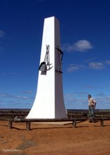
|  Goldfields Pipeline Goldfields Pipeline
Pipeline Display on Lookout Hill, Southern Cross. Water is piped from Mundaring near Perth to the Goldfields through 557km of Steel Pipeline.
|  Centenary of Southern Cross Centenary of Southern Cross
Commemorating the Australian Bicentenary 1788-1988 and Southern Cross Centenary 1888-1988.
|
 Goldfields Pipeline Goldfields Pipeline
The town of Southern Cross framed by Pipeline.
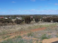
|  Southern Cross 1 Southern Cross 1
View of town from Lookout Hill.
|  Southern Cross 2 Southern Cross 2
The first major Gold Discovery of the Eastern Goldfields District was made here in 1888.
|  Southern Cross 3 Southern Cross 3
Southern Cross now has a mixture of Gold Mining and Wheat Farming.
|
 Southern Cross 4 Southern Cross 4
Southern Cross is located 357 m above sea level, and is 368 km east of Perth on Great Eastern Highway.
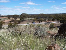
|  Southern Cross 5 Southern Cross 5
Goldfields Pipeline running parallel with Great Eastern Highway.
|  Southern Cross 6 Southern Cross 6
Risely and Toomey claimed they had been led to their discovery of Gold by the Southern Cross and they named the goldfield after the constellation.
|  Southern Cross 7 Southern Cross 7
Today the area produces oats, barley, wheat, sheep and gold but the average annual rainfall of 279 mm means that the land is marginal.
|
 Southern Cross 8 Southern Cross 8
In recent times the fluctuating price of gold has seen renewed interest in the Southern Cross area with both Broken Hill Metals NL and Golden Valley Mines NL being the main operators in the region.
|  Salmon Gums at Coolgardie Salmon Gums at Coolgardie
Late afternoon light on these majestic Salmon Gums (Eucalyptus salmonophloia) at Coolgardie.
|  Grave of Ernest Giles Grave of Ernest Giles
The Grave of early Explorer Ernest Giles in Pioneer Cemetery, Coolgardie.
|  Plaque Ernest Giles Plaque Ernest Giles
Respected Explorer Ernest Giles, 1835-1897.
|
 Main Street of Coolgardie Main Street of Coolgardie
Late afternoon on the main street of Coolgardie which is 558 km east of Perth.
|  Dramatic Sky Dramatic Sky
Dramatic Sky over now vacant land and rubble from prior buildings at Coolgardie.
| 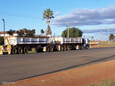 Heavy Haulage Heavy Haulage
These wide streets were made for Camel Trains which have now been replaced by Heavy Haulage Trucks.
|  Road Train Road Train
Road Train under Dramatic Coolgardie Sky.
|
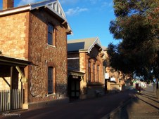
 Historic Coolgardie Buildings Historic Coolgardie Buildings
Two of Coolgardie's Historic Buildings.
|  Restored Coolgardie House Restored Coolgardie House
This Coolgardie House is beautifully maintained.
|  Verandah and Rain Water Tank Verandah and Rain Water Tank
There is a Rain Water Tank at the end of the Verandah.
|  Coolgardie General Store Coolgardie General Store
|
 Window Display Window Display
The Window Display in an old Shop at Coolgardie.
|  Abandoned House Abandoned House
Derelict House at Coolgardie.
|  Historic Old Goal Historic Old Goal
Golden Rays of the evening Sun on the Historic Old Goal at Coolgardie.
|  Golden Sun Rays Golden Sun Rays
Golden Rays of the Setting Sun on the Historic Buildings of Coolgardie.
|
 Warden's Court Building Warden's Court Building
Historic Warden's Court Building which is now used as a Visitor's Centre.
|  Historic Warden's Court Historic Warden's Court
Historic Warden's Court Building at Coolgardie.
|  Typical House in Fading Light Typical House in Fading Light
Typical Houses in Coolgardie were built of Corrugated Iron.
| 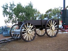 Coolgardie Museum 1 Coolgardie Museum 1
Display at Ben Prior's open air Museum, Coolgardie.
|
 Coolgardie Museum 2 Coolgardie Museum 2
Display at Ben Prior's open air Museum, Coolgardie.
|  Coolgardie Museum 3 Coolgardie Museum 3
Display at Ben Prior's open air Museum, Coolgardie.
|  Coolgardie Museum 4 Coolgardie Museum 4
Display at Ben Prior's open air Museum, Coolgardie.
|  Coolgardie Museum 5 Coolgardie Museum 5
Display at Ben Prior's open air Museum, Coolgardie.
|
