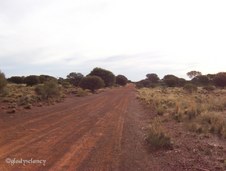
 Gunbarrel Highway continues Gunbarrel Highway continues
The Gunbarrel Highway was surveyed and constructed by Len Beadell.
|  The Len Beadell Desert Bloodwood Tree The Len Beadell Desert Bloodwood Tree
Len Beadell put a plaque on this Desert Bloodwood Tree (Eucalyptus terminalis).
|  Plaque on Len Beadell Tree Plaque on Len Beadell Tree
|  Shadow of Len Beadell Tree across Gunbarrel Highway Shadow of Len Beadell Tree across Gunbarrel Highway
|
 The Len Beadell Desert Bloodwood Tree The Len Beadell Desert Bloodwood Tree
Len Beadell put a plaque on this Desert Bloodwood Tree (Eucalyptus terminalis).
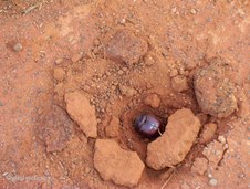
|  Mulga Ant's Nest Mulga Ant's Nest
The Mulga Ant's Nests have a slit-like opening instead of the usual round hole.
|  Junction Gunbarrel Highway and Heather Highway Junction Gunbarrel Highway and Heather Highway
|  The Gunbarrel Highway goes on ahead The Gunbarrel Highway goes on ahead
|
 Looking back on Gunbarrel Highway behind us Looking back on Gunbarrel Highway behind us
|  Turning onto the Heather Highway Turning onto the Heather Highway
|  Spinifex and Mulga vegetation Spinifex and Mulga vegetation
|  Early Morning on Heather Highway Early Morning on Heather Highway
|
 Roadside Wildflowers at Dawn Roadside Wildflowers at Dawn
|  Green Crumbweed (Chenopodiaceae) growing between the stones Green Crumbweed (Chenopodiaceae) growing between the stones
|  Wildflowers along Heather Highway Wildflowers along Heather Highway
Verbenaceae. Dicrastylis (Dicrastylis exsuccosa)
|  Small Beetle burrowing in the road Small Beetle burrowing in the road
|
 Breakaways, 90 kms east of Warburton Breakaways, 90 kms east of Warburton
|  Caves where Stick Nest Rats live Caves where Stick Nest Rats live
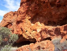
|  Rock Formations Rock Formations
|  Close-up of Cave in Breakaways Close-up of Cave in Breakaways
|
 Breakaways viewed from road Breakaways viewed from road
| 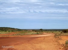 Great Central Road between Warburton and Giles Great Central Road between Warburton and Giles
We are now travelling on the Great Central Road between Warburton and Giles in Western Australia.
|  Stopped for Lunch Stopped for Lunch
|  Two types of Lichen on Rocks Two types of Lichen on Rocks
|
 Tjukurlapini Rockholes (Gnamma Holes) Tjukurlapini Rockholes (Gnamma Holes)
The Tjukurlapini Rockholes, or Gnamma Holes, were used as a water supply by the Aborigines.
|  Rick at Tjukurlapini Rockholes (Gnamma Holes) Rick at Tjukurlapini Rockholes (Gnamma Holes)
The Tjukurlapini Rockholes, or Gnamma Holes, were used as a water supply by the Aborigines.
|  Rick and Joe at Tjukurlapini Rockholes Rick and Joe at Tjukurlapini Rockholes
|  Great Central Road at Tjukurlapini Rockholes Great Central Road at Tjukurlapini Rockholes
|
 Magnificent Rawlinson Range Magnificent Rawlinson Range
|  Giles Weather Station Giles Weather Station
The Giles Weather Station was established in 1956 by the Weapons Research Establishment to provide weather data for the UK atomic weapons tests at Emu Plains and Maralinga, and to support the rocket testing program based at Woomera. In 1972, it was transferred to the Bureau of Meteorology.
| 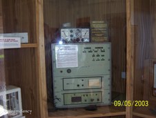 Giles Weather Station Codan Radio Giles Weather Station Codan Radio
|  Giles Weather Station Sunshine Recorder Giles Weather Station Sunshine Recorder
|
 Giles Weather Station Display Giles Weather Station Display
| 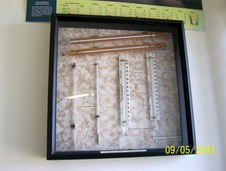 Giles Weather Station Display of Instruments Giles Weather Station Display of Instruments
|  Giles Weather Station Display Giles Weather Station Display
|  Map made from Burnt Matches Map made from Burnt Matches
|
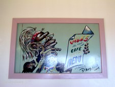 Giles Weather Station cartoon by Len Beadell Giles Weather Station cartoon by Len Beadell
|  Giles Weather Station cartoon by Len Beadell Giles Weather Station cartoon by Len Beadell
|  Giles Weather Station cartoon by Len Beadell Giles Weather Station cartoon by Len Beadell
|  Remains of the Blue Streak Rocket Remains of the Blue Streak Rocket
The remains of the Blue Streak Rocket which landed near Giles Weather Station.
|
