 Bremer Bay Mural 1 Bremer Bay Mural 1
Salmon (Western Australian): Catch your own from the large schools that inhabit our waters between February-May.
|  Bremer Bay Mural 2 Bremer Bay Mural 2
Southern Right Whale: Can be seen frolicking in our waters between July-September.
|  Bremer Bay Mural 3 Bremer Bay Mural 3
Leafy Sea Dragon: See one for yourself along the dive trail situated at Little Boat Harbour.
|  Bremer Bay Bremer Bay
Bremer Bay was named in 1848 by Surveyor General John Septimus Roe. This popular holiday and fishing resort has a permanent population of 300 and is situated near the Fitzgerald National Park.
|
 Pristine Waters of Bremer Bay Pristine Waters of Bremer Bay
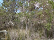
|  Coastal Vegetation Coastal Vegetation
|  Eucalypt species in flower Eucalypt species in flower
| 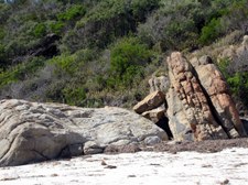 Rock Formations Rock Formations
|
 Bremer Bay Town Beach Bremer Bay Town Beach
The azure blue water and endless white sand make the Town Beach popular for swimming, or fishing from the rocks.
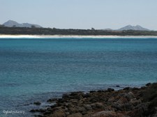
|  Zoomed across Bremer Bay Zoomed across Bremer Bay
Mt Maxwell (184m) and West Mt Barren (340m) on the horizon.
|  Clouds moving over Bremer Bay Clouds moving over Bremer Bay
|  View across the Bay View across the Bay
|
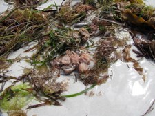
 Seaweed left by the Tide Seaweed left by the Tide
|  Remains of a Shell Remains of a Shell
|  White Sand and Rock Formations White Sand and Rock Formations
|  White Sands of James Cove White Sands of James Cove
|
 Walking towards the Sandbar at mouth of Bremer River Walking towards the Sandbar at mouth of Bremer River
|  Left by the receding Tide Left by the receding Tide
|  Life on the White Sand Life on the White Sand
|  Sand Dune Re-vegetation Sand Dune Re-vegetation
|
 Dune Cabbage introduced from Africa Dune Cabbage introduced from Africa
Dune Cabbage (Arctotheca populifolia), prostrate perennial with thick silver hairy stems and leaves. Introduced from Africa, grows only on coastal dunes, used as a stabilizing plant.
|  The Sandbar at mouth of Bremer River The Sandbar at mouth of Bremer River
|  Off Road Vehicle Prohibition Area Off Road Vehicle Prohibition Area
|  Wind Turbine generates Power Wind Turbine generates Power
|
 Black-winged Stilts in the shallows of Wellstead Estuary Black-winged Stilts in the shallows of Wellstead Estuary
|  Paperbark Trees and Sedges in the Wetlands Paperbark Trees and Sedges in the Wetlands
|  Recreational Areas Recreational Areas
|  Last view of Bremer Bay beyond the Sandbar Last view of Bremer Bay beyond the Sandbar
|
 Peppermint Trees beside the Road Peppermint Trees beside the Road
Agonis flexuosa grows to 15m and occurs on coastal sands and limestone heaths.
|  At the end of Cuneo Drive, Bremer Bay At the end of Cuneo Drive, Bremer Bay
|  James Cove across the Bay James Cove across the Bay
|  Mt Maxwell & West Mt Barren above James Cove Mt Maxwell & West Mt Barren above James Cove
Viewed from Lookout at end of Cuneo Drive.
|
 View across the Bay towards Peppermint Beach area View across the Bay towards Peppermint Beach area
|  Blue Waters of Bremer Bay Blue Waters of Bremer Bay
|  Rock Cairn Rock Cairn
The original rock cairn on this site was built by the early Wellstead family under Government maritime supervision as a means of alerting visiting coastal ships when there were travellers or cargo to go aboard. By means of a white day flag or a lantern at the head of the central pole the crew would know that there could be, for example, wool, tree bark or produce to be picked up for one or other of the ports around the south coast which they visited regularly.
|  Plaque on Rock Cairn Plaque on Rock Cairn
The service was phased out in the early 1930s when shipping ceased and road transport took over. With the passing years the cairn collapsed and suffered from vandalism. In the 1980s the local Progress Assoication, together with the then active Tourism Committee, decided to reconstruct the cairn as something of historical interest, but it was built in a slightly different form from the original.
|
 Windpower for the town Windpower for the town
|  Looking at the Southern Ocean Looking at the Southern Ocean
|  Waves splash on the Rocks below Waves splash on the Rocks below
|  Rocky Island off-shore Rocky Island off-shore
|
