
1
Tasmania #06 Collage
| 
2
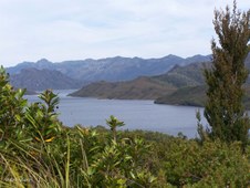
Panorama Lake Pedder
Lake Pedder was created by the construction of a large rockfill dam on the upper reaches of the Huon River at Scotts Peak and another on the Serpentine River above its junction with the Gordon. A small dam was also constructed across a low marshy area at Lake Edgar, near Scotts Peak, thus flooding the Original Lake Pedder and all its natural beauty.
| 
3
Lake Pedder
The Man-made Lake Pedder has a surface area of 242 square kilometres and a total volume of 3.3 cubic kilolitres. Variation in the level of Lake Pedder is limited to 1.5 metres. This enhances its popularity as a venue for fishermen and tourists.
|

4
Lake Pedder
The wild beauty of the original Lake Pedder and its surrounds was formed 10,000 years ago, at the end of the last ice age. There was a wall of mountains, guarding what's called a glacial outwash lake, with high dunes and a beach of fine pink quartz sand.
| 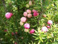
5
Mountain Berry (Cyathodes)
Endemic to Tasmania
| 
6
Snow Berry (Gaultheria hispida)
At Lake Pedder
|
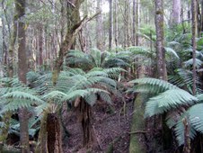
7
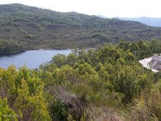
Lake Pedder
Campaign to restore Lake Pedder in the heart of the Tasmanian wilderness World Heritage Area. In 1972 the flooding of Lake Pedder for a minor hydro-electric scheme created an international environmental furore. Though Tasmania's authorities cling to the age of large engineering works, there are renewed calls for the waters to be drained to restore Lake Pedder to its natural splendor.
| 
8
Native Plum (Cenarrhenes nitida)
At Lake Pedder
| 
9
Lake Pedder
Some Tasmanians believe that Lake Pedder might again see the light of day. In 1996, a Federal Enquiry confirmed it was scientifically possible for Pedder to be restored - but money, and perhaps the political will to proceed, are short.
|
10
Lake Pedder
Lake Pedder provides about 41 percent of the water used in the Gordon Power Station. Water from the lake flows via McPartlan Canal into Lake Gordon.
| 
11
Gordon Road
The Gordon Road was built during the 1960's to access the construction sites of the Gordon River Power Developement.
| 
12
Golden Rosemary ((Oxylobium ellipticum)
|

13
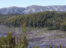
Lake Gordon
The Gordon River scheme has created the largest water storage in Australia. This is a region of very high rainfall with an average of 2450mm falling in the development's catchment area every year. Snowmelt from surrounding mountains also replenishes the storages each spring.
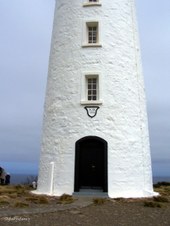
| 
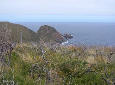
14
Lake Gordon
Lake Gordon from roadside. Low water level shows wasted timber lost though hastily flooding the valley before it could be logged.
| 
15
Lake Gordon
Lake Gordon from roadside - zoomed in to show low water level revealing wasted timber lost because the valley was hastily flooded before it could be logged. Some call it Progress, others call it Man-made Destruction.
|

16
Gordon Dam
Lake Gordon was created by the building of a 140 metre high concrete arch dam across the Gordon River above its junction with the Serpentine River. Water from Lake Gordon and Lake Pedder is used in the underground Gordon Power Station situated near the Gordon Dam.
| 
17
Gordon Dam
Lake Gordon has a surface area of 272 square kilometres and total volume of 11.9 cubic kilolitres. It represents 35 percent of the Tasmania's total energy storage capacity.
| 
18
Gordon Dam
Water from Lake Gordon drops through an intake tunnel to the Gordon Power Station, 183 metres underground before rejoining the Gordon River downstream of the dam.
|

19
Gordon Dam information
Height 140 metres; Length of Crest 198 metres; Thickness at Base 17.7 metres; Thickness at Crest 2.8 metres; Volume of Concrete 154,000 cubic metres; Volume of Water at full capacity 12,450 million cubic metres.
| 
20
Gordon Dam
From Gordon Dam site showing low water level and towering cliffs rising above lake.
| 
21
Lake Gordon
Lake Gordon from Gordon Dam site, zoomed in to show the low water level revealing the waste of timber because the valley was hastily flooded before logging could take place.
|

22
Quartz Cliffs
Towering Quartz Cliffs rise above the Gordon Dam.
| 
23
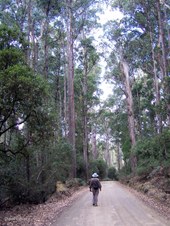
Tall Trees Walk
Returned to Mt Field National Park for the Tall Trees Walk.
| 
24
Swamp Gums
Swamp Gums (Eucalyptus regnans) in Mt Field National Park.
|

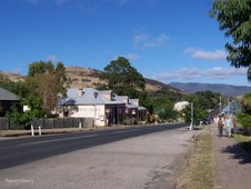
25
Tall Trees Walk, Mt Field National Park
| 
26
Tree Ferns
Mt Field National Park.
| 
27
Tall Trees Walk, Mt Field National Park
|

28
Mt Field's Tallest
Tasmania's Swamp Gum (Eucalyptus regnans) is the tallest Hardwood and the tallest Flowering Plant in the World. The tallest recorded in Tasmania was 98 m high.
| 
29
Tall at 79 metres
This Swamp Gum is around 79 m tall and still growing. The top is occasionally pruned by the wind.
| 
30
Tall Trees Walk at Mt Field National Park
|

31
Misty Harbour
Misty rain at Kettering while waiting to board the Ferry to Bruny Island.
| 
32
Seagulls and Shags at Kettering
| 
33
Leaving Kettering
On board the Ferry from Kettering to Roberts Point, Bruny Island.
|

34
Kettering hillside from Ferry
| 
35
McCrackens Gully on Bruny Island
| 
36
Birdwatchers
Searching for the elusive Forty-Spotted Pardalote which is endemic to Tasmania and reliant on one species of Eucalypt for survival.
|

37
Private Forest Reserve
McCrackens Gully which contains White Gum (Eucalyptus viminalis) which is crucial to the survival of the Forty-Spotted Pardalote.
| 
38
McCrackens Gully
More than half of the original White Gum forest and woodland has been cleared thus reducing the habitat of the Forty-Spotted Pardalote.
| 
39
Lacking Sunshine on the McCrackens Gully road
|

40
Coast of Bruny Island
| 
41
Unusual Seed Pods
| 
42
On Bruny Island
|

43
Still Birdwatching in McCrackens Gully, Bruny Island
| 
44
Natural Weatherboards
These walls are made Weatherboards with natural edges that have not been trimmed as usual. At Adventure Bay, Bruny Island.
| 
45
Adventure Bay, Bruny Island
|

46
Adventure Bay Beach on Bruny Island
| 
47
Bruny Island Coastline
Bruny Island has approximately 300 km of coastline.
| 
48
Bruny Island coastline
|
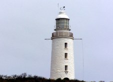
49
Cape Bruny Lighthouse
Latitude 43° 29.6' S, Longitude 147° 08.5' E. The Cape Bruny Lighthouse is is the third oldest Commonwealth lightstation in Australia. The lighthouse is also the oldest continuous lighthouse tower in Australia under Commonwealth control.
| 
50
View of Bay
Overlooking the Bay and Keepers Cottages from Cape Bruny Lighthouse.
| 
51
Southerly View
Looking south to the Southern Ocean from Cape Bruny Lighthouse.
|
52
Lighthouse Entrance
Colonial architect John Lee Archer designed the 13-metre high Cape Bruny Lighthouse. It was built from local stone and cost 2,500 pounds to build even though it was constructed using Free convict labour.
| 
53
Upper Lighthouse
The Cape Bruny Lighthouse was lit in 1838 and is the oldest continuously-manned lighthouse in Australia. It was decommissioned in 1996, when it was replaced by a solar powered tower. The original parabolic reflectors used approximately half a litre of sperm (whale) oil every hour of use.
| 
54
Information
On a clear day the Cape Bruny Lighthouse offers views to two white-tipped islands, Pedra Branca and Eddystone Rock, 22 nautical miles to the south-west.
|

55
Historic Map
Historic Map of Southern Tasmania. Abel Tasman was the first European in the region and partially chartered the shoreline in 1642. Tobias Furneaux followed in 1773 and named Adventure Bay. The Island is named after the French explorer Bruny d'Encastrecasteaux who visited between 1792-93.
| 
56
Southern Ocean from Cape Bruny Lighthouse
| 
57
Looking South from Cape Bruny Lighthouse
|

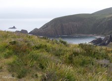
58
Rugged Coastline
Coastal Cliffs to the south of Cape Bruny Lighthouse.
| 
59
White Heath at Cape Bruny
| 
60
Tea-tree (Leptospermum) at Cape Bruny
|

61
Lighthouse Keeper's Cottages
| 
62
Cape Bruny Lighthouse
| 
63
Vehicular Ferry
Waiting to board the vehicular ferry Mirambeena for return to Kettering.
|

64
Roberts Point on North Bruny Island
| 
65
Roberts Point
Surrounding landscape at Roberts Point while waiting to board the ferry.
| 
66
Boarding Mirambeena
Ready to board the Mirambeena for the 30 min journey to Kettering.
|

67
Sunset over Constitution Dock at Hobart
| 
68
Hobart Sunset
Hobart Sunset through the masts of the Lady Nelson at Constitution Dock,Hobart.
| 
69
Hobart Sunset
Lady Nelson at Sunset over Constitution Dock, Hobart.
|

70
Historic Richmond Bridge
The Richmond Bridge, built in 1823, is the oldest bridge in Australia still in use. Situated in Richmond, Tasmania, roughly 25kms from the state capital, Hobart, the Richmond Bridge spans the Coal River in the heart of a region known for it’s boutique wineries, history, and beauty.
| 
71
Richmond Bridge
The bridge was built by convict labour and, like much of Tasmanian convict history, the bridge is shrouded in tales of hardship, tragedy, and restless spirits.
| 
72
Historic Richmond Bridge
|

73
Red Berries along river bank near Richmond Bridge
| 
74
Coal River
Reflections in Coal River at Richmond Bridge.
| 
75
Coal River
Coal River looking upstream from top of Richmond Bridge.
|

76
Coal River
Coal River looking downstream from top of Richmond Bridge.
| 
77
Richmond Bridge
Looking through the arch under Richmond Bridge.
| 
78
Richmond Bridge
View through the arch of Richmond Bridge.
|
79
Richmond Bridge
Beautiful Sandstone of the convict-built historic Richmond Bridge.
| 
80
Colonial Accommodation
Australia's most original Georgian village 24kms from Hobart. First explored in 1803 by Lieutenant Bowen. A few years later when the settlers came and the area was called Sweetwater. The discovery of coal along its banks caused the river to be named the Coal River, and the town itself (officially named by Lt Gov. William Sorell on February 23, 1824), was so called as the 90 acres on which it was established had once been part of a property called Richmond Park.
| 
81
Richmond Cottages
Richmond is a remarkably well preserved Georgian township which offers a rare insight into the types of buildings which some of Australia's earliest settlers lived in.
|

82
Peppercorn Gallery
Richmond's close proximity to Hobart (which is only 27 km away) has ensured that it has become one of the most popular tourist attractions in Tasmania. This has meant that old Georgian stone houses, commercial buildings and hotels have been converted into gift shops, Devonshire tea places, restaurants, craft shops, and museums.
| 
83
Richmond Village Store
| 
84
Waiting for Dad
Waiting for their Dad while he was in the Richmond Village Store.
|

85
Mural on Richmond Village Store
| 
86
Mural on Richmond Village Store
| 
87
Mural on Richmond Village Store
|

88
Live to Ride
Throughout Tasmania we saw many members of the Ulysses Club who were promoting motorcycle awarness as they travelled to Ulverstone for their 23rd Annual General Meeting.
| 
89
Ride to Live
The Ulysses Club is an Australian motorcycle club that caters for the needs of the more mature rider. The club was established in December 1983 and is the largest motorcycle club in the southern hemisphere.
| 
90
Richmond Arms Hotel
One of the town's highlights is the gracious Richmond Arms Hotel at 42 Bridge Street which dates from 1888. It replaced the Lennox Hotel (1827) which had been burnt down two years earlier. The elegant cast iron lacework is a symbol of the confidence and flair of the Victorian era. It contrasts sharply with the rather ascetic Georgian buildings which dominate in the town.
|

91
Hollyhock Cottage
It was called Hollyhock Cottage, but no Hollyhocks in sight!
| 
92
Red Flowering Gum at Hollyhock Cottage, Richmond
| 
93
Richmond Church
|

94
Richmond Scene
| 
95
Model Village
| 
96
Richmond Street Scene
|

97
Richmond Post Office
| 
98
Richmond Letter Box
| 
99
Return to Richmond Bridge
Ducks resting in heavy shade in foreground.
|

100
Ducks at Richmond Bridge
| 
101
Ducks at Richmond Bridge
| 
102
Historic Richmond Bridge
The sandstone arches of the Richmond Bridge, set against the hills of the Coal River Valley, have straddled Tasmania's Coal River since their completion in 1825. Built by convict labour in its picturesque setting and framing views of one of Richmond township's historic churches, the Richmond Bridge has long inspired artists, tourists and lovers of beautiful places almost since it was completed.
|

103
Coal River reflections near Richmond Bridge
| 
104
Historic Richmond Bridge
The bridge itself has outstanding heritage value to the nation because of its rarity as the earliest Australian large stone arch bridge and because it has survived with few significant changes since it was first constructed. It is widely recognised across the nation featuring in numerous publications, tourist and historic literature and in the work of major Australian artists. Images of Richmond Bridge have also appeared on postage stamps.
| 
105
Coal River looking downstream from Richmond Bridge.
|
