
1
Tasmania #5 Collage
| 
2
Tessellated Pavement
The Tessellated Pavement in the Tasman National Park is an unusual geological formation, which gives the rocks the effect of being rather neatly tiled.
| 
3
Tessellated Pavement
The pavement appears tessellated (it's tiled) because the rocks forming it were fractured by earth movements.
|

4
Tessellated Pavement
The flatness of the pavement is due to initial erosion by waves carrying sand and gravel and nearer to the cliff, to chemical action by sea water.
| 
5
Pittosporum bicolor
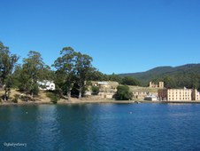
Pittosporum means Pitch Fruit referring to the bitter-tasting sticky seeds which may be seen after the capsule opens.
| 
6
Pirates Bay
The Tessellated Pavement area of Pirates Bay.
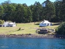
|

7
Tall Eucalypts at the car park
| 
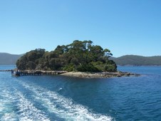
8
Towering Trees
| 
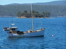
9
Pirates Bay
|

10
Martin Cash Memorial
Memorial to mark the Centenary of the Death of Martin Cash. He was known as a Gentleman Bushranger because he never used Violence. He received a Pardon and died a Free Man on 27 Aug 1877.
| 
11
Tasman Arch
| 
12
Eucalypt Buds
|

13
Eucalypt Bark
| 
14
Tasman Sea
Rugged Coast joining the Tasman Sea on east coast of Tasmania.
| 
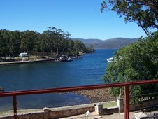
15
Devil's Kitchen 60 m deep
|

16
Looking down into Devil's Kitchen
| 
17
Port Arthur
Panorama of the Historic Site of Port Arthur on the Tasman Peninsula.
| 
18
Early 1860's
View of Settlement Hill across Mason Cove, early 1860s. The large building in the foreground is the Penitentiary, with the Commissariat Stores on the waterfront to the left. Visible at the top left of the photograph is the semaphore.
|

19
Ferry Terminal
Departure point for Harbour Cruises to Point Puer and Isle of the Dead.
| 
20
Port Arthur Cruises
| 
21
Port Arthur viewed from Ferry
|
22
Dockyards
Between 1834 and 1848 Port Arthur was home to an industrious shipbuilding enterprise that saw 15 large timber vessels, and over 140 smaller boats, built at the dockyard.
| 
23
Australian Red Ensign
The Australian Red Ensign - Merchant Navy, as for the Australian flag, but with a red field with white stars. Proclaimed in the Flags Act 1953. Covers Australian registered ships under section 30 of the Shipping Registration Act 1981.
| 
24
Dockyards viewed from Ferry
Clerk of Works House on Left, and Shipwrights House on Right, with Lime Kiln in foreground.
|

25
Jetty at Point Puer
3,000 boys ranging in age from 9 to 18 passed through Point Puer Boys' Prison from 1834-49. It was the first reformatory built exclusively for juvenile male convicts in the British Empire and was renowned for its regime of stern discipline and harsh punishment.
| 
26
Isle of the Dead
The Isle of the Dead is a small island located in the harbour adjacent to the Port Arthur Historic Site. Originally called Opossum Island, it was selected as a burial place by the Reverend John Manton in 1833.
| 
27
Isle of the Dead
Between 1833 and 1877, about one thousand burials took place on the island. The majority were convicts and ex-convict paupers who were buried mostly in unmarked graves on the lower part of the island. The graves of free people were located on the high side of the island and were sometimes marked by elaborate headstones cut by the convict stonemasons.
|

28
Port Arthur viewed from returning Ferry
| 
29
Fishing Boat at anchor in Mason Cove
| 
30
Port Arthur from Jetty
|

31
Tasmanian Blue Gums
An avenue of Tasmanian Blue Gums (Eucalyptus globulus) line the road to the Dockyards at Port Arthur.
| 
32
Lime Kiln
| 
33
Lime Kiln
Historic Lime Kiln built in the Dockyard area of Port Arthur in 1854.
|

34
Belladonna Lilies at the Dockyards
| 
35
Eucalyptus globulus
Tasmanian Blue Gum timber quickly established a reputation with early settlers for its toughness and durability. Its timber is stronger and denser than other similar types of gum tree and is suitable for ship building and similar uses.
| 
36
Younger Blue Gums
Near Port Arthur Dockyards.
|

37
Young Tree
Young Tasmanian Blue Gum shows a mix of blue juvenile leaves on lower half and mature green leaves on upper half.
| 
38
Government Gardens
A distinct precinct of the Port Arthur Historic Site, containing a historically comprised landscape and built features, plant materials and other elements of high significance. The gardens were originally established in the late 1830's as an outdoor leisure space for the civil and military officials at Port Arthur, and survived until well after the closure of the settlement in 1877.
| 
39
Government Gardens
The elements of Government Gardens display deliberate design and arrangements reflecting the order and hierarchy of the military and convict occupation of the Historic Site. The Government Cottage Gardens, as well as the Commandant's Garden, are the only two formal gardens within the present Historic Site dating from the convict period reflecting various aspects of civic life.
|

40
Oyster Plant
The Government Gardens were reconstructed in accordance with an 1858 survey. Extensive research of historic photographs, palynological soil analysis and archaeological investigations were used to establish the planting species, the type and location of paths, fences and other landscape features originally extant within the precinct. The central pathway, fountain and plantings from the original 1840s were retained.
| 
41
Himalayan Honeysuckle
Government Gardens, Port Arthur.
| 
42
Ginger Lily (Hedychium gardnerianum)
Government Gardens, Port Arthur.
|

43
Colourful in Orange
Government Gardens, Port Arthur.
| 
44
Asylum
By the early 1860's a large numberof men who were in need of care shuttled between the Pauper's Depot, the Hospital and the Lunatic Asylum, depending on their state of mental health. Most of the men in the Lunatic Asylum would today be diagnosed with depression, dementia or mental disability. This Ideal Asylum was designed to cure the Lunatics in a calm, clean environment with kindness, exercise and amusement, religious consolation and work to soothe the mind.
| 
45
Pauper's Mess, Asylum, Separate Prison
|

46
Hospital
The Hospital built in 1841-42 was the third constructed at Port Arthur. Placed on top of Settlement Hill, above the prisoners' barracks, the hospital was made up of wards, kitchen, baking room, laundry and morgue. As the convicts of Port Arthur worked in heavy industries such as timber-getting, accident victims at the hospital were common. The hospital was staffed by a doctor and a number of untrained convict orderlies. In the 1890s, the hospital building was sold to the Catholic Church, but was unfortunatley burnt in the 1895 and 1897 fires.
| 
47
Guard Tower
Upper level of the Guard Tower which was built on high ground overlooking the settlement at Port Arthur.
| 
48
Inside Guard Tower
|
49
Mason Cove
View over Mason Cove from the upper level of the Guard Tower, Port Arthur.
| 
50
Penitentiary from Guard Tower at Port Arthur
| 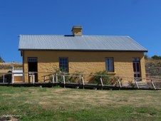
51
Old School House, Port Arthur
|

52
Officer's Quarters
| 
53
Decorative Arch with Officer's Quarters beyond
| 
54
Corner of Compound Wall
Military area of Port Arthur.
|

55
Compound Wall
Military area of Port Arthur.
| 
56
Guard Tower
The Guard Tower contained a storeroom for guns and ammunition, a guard room and a watch tower. After the settlement closed, most of the military complex was demolished. The 1897 bushfires destroyed much of waht remained.
| 
57
Commandant's House
The most senior official at Port Arthur was the Commandant. Located on the fringe of settlement, the Commandant's House enjoyed a commanding prospect over the rest of the settlement. The house began life in 1833 as a simple wooden cottage, to become a many-roomed complex fringed by ornate gardens and pathways. High masonry walls divided the residence from the rest of settlement. After the close of the convict period in 1877, the building became the Carnarvon Hotel in 1885 and later a guest house which operated until the 1930's.
|

58
Interior of the Commandant's House
| 
59
Penitentiary
The former flourmill and granary was converted into the Penitentiary. This mill had been completed in 1845 to try to supply all the settlement's flour. It was powered by both a water wheel and a convict-driven treadmill.
| 
60
Penitentiary
The Penitentiary was gutted by fires in 1897 but symbolises the machine of reform at work, containing within itself both the machinery of punishment and of self-improvement.
|

61
Penitentiary
| 
62
Policeman's Residence
The Policeman's Residence was a later addition to Port Arthur.
| 
63
Church
The Church and the Commandant's House stand on the highest ground at either end of the site, expressing the absolute authority of God and the State, and their earthly representatives the Parson and the Commandant.
|

64
Inside Church
Religion was most energetically engaged in the process of reform. Everyone had to attend church. Each Sunday up to 1100 people worshipped here. The Convicts were marched to Church by armed guards and sat in the body of the building, while the free people sat on raised wooden pews to the left and right behind a curtain. A choir of well-behaved convicts sang hymns.
| 
65
Church
Constructed in 1836-37, Port Arthur's church is a tribute to its convict builders. Built of timber and stone, the church overlooked the convict settlement from the high ground to the west and could accommodate a prison population of over one thousand souls. Never consecrated due to its usage by a number of different denominations, the church was representative of the authorities goals to reform through religion. Standing throughout the convict period, the church was destroyed in an 1884 fire and has since seen many conservation works throughout the 20th century.
| 
66
Violent Crime
On Sunday 28 April 1996, the Port Arthur Historic Site was the site of a devastating violent crime. In this area, and at other locations nearby, a single gunman killed 35 people and injured dozens more. Staff from the Historic Site were among the victims. The man was captured next day. He pleaded guilty and was sentenced to imprisonment for life with no eligibility for parole.
|

67
Memorial Garden
Many people still suffer as a result of the tragedy. It was agreed that a memorial garden, incorporating the shell of the Broad Arrow Cafe, would be established as a place of quiet beauty and calm contemplation.
| 
68
Memorial Garden
View from Memorial Garden at Port Arthur. In this peaceful place, open to the wind, rain and sky, we may reflect on that tragedy, and remember its many victims.
| 
69
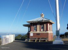
Mt Nelson Signal Station
Historic Signal Station on Mt Nelson overlooking Hobart and the Derwent River.
|

70
State Flag of Tasmania
The State Flag of Tasmania flying on the historic Mt Nelson Signal Station.
| 
71
View from Signal Station
| 
72
View from Signal Station
|

73
Tasman Bridge
Hobart and Tasman Bridge viewed from Mt Nelson Signal Station.
| 
74
Hobart
Hobart viewed from Mt Nelson Signal Station.
| 
75
Hobart
Hobart viewed from Mt Nelson Signal Station.
|

76
Tasman Bridge
Tasman Bridge and Hobart viewed from Mt Nelson Signal Station.
| 
77
Tasman Bridge
Tasman Bridge and Hobart viewed from Mt Nelson Signal Station.
| 
78
Suburban Hobart
Suburbs of Hobart viewed from Mt Nelson Signal Station.
|

79
Outer Hobart
Outer areas of Hobart viewed from Mt Nelson Signal Station.
| 
80
Towards Tasman Peninisula
Looking SE towards Tasman Peninsula from Mt Nelson Signal Station.
| 
81
Towards Tasman Peninisula
Looking towards Tasman Peninsula from Mt Nelson Signal Station.
|

82
Eagle's Nest
Eagle's Nest high in Swamp Gum (Eucalyptus regnans) at Mt Field National Park.
| 
83
Mt Field National Park
The natural beauty of Mt Field has been officially recognised for over one hundred years. Tasmania's first nature reserve was created around Russell Falls in 1885. The area set aside for protection and public enjoyment was then greatly extended with the formation of the Mt Field National Park in 1916.
| 
84
Russell Falls in Mt Field National Park
|

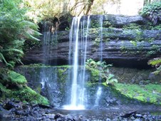
85
Russell Falls in Mt Field National Park
| 
86
Lush Tree Ferns
Beautiful Tree Ferns beside the magnificent Russell Falls at Mt Field National Park.
| 
87
Russell Falls
Black washed rocks at the base of Russell Falls in Mt Field National Park.
|

88
Russell Falls
Lower level of Russell Falls at Mt Field National Park.
| 
89
Tree Fern Walk
Mt Field National Park.
| 
90
Tasmanian Pademelon
Pademelon in a cool dark spot in the Rainforest at Mt Field National Park.
|

91
Dogwood
Dogwood (Pomaderris apetala) in Mt Field National Park.
| 
92
Swamp Gum
Russell Falls walk in Mt Field National Park.
| 
93
Swamp Gum
Swamp Gum (Eucalyptus regnans) is the tallest flowering plant in the world. It can grow to 100 metres high. Known as Tasmanian Oak, it is used extensively for house construction and for making furniture.
|

94
Creepy-Crawly Walk
Moss covered trunk along the Creepy-Crawly Walk of the wet Myrtle Forest.
| 
95
Orange Fungi
Brilliant Orange Fungi in the cool temperate rainforest of the Creepy-Crawly Walk.
| 
96
Sunlit Trees
Trees on the Creepy-Crawly Walk.
|

97
Treetops
Trees on the Creepy-Crawly Walk.
| 
98
Looking Skywards
Trees on the Creepy-Crawly Walk.
| 
99
Horizontal Thicket
Horizontal (Anodopetalum biglandulosum) is known as the curse of bushwalkers in Tasmania's forests. Horizontal is only found in Tasmania and grows as an understorey species in wet eucalypt and farinforests. The tough springy wood has a fine even grain which polishes well. Horizontal has long been used for axe and broom handles, and is now popular as a craftwood.
|

100
Climbing Heath
Prionotes cerinthoides is a Tasmanian endemic alpine plant which is often found in shady rainforest.
| 
101
Climbing Heath
Prionotes cerinthoides beside the Creepy-Crawly Walk.
| 
102
Sentinel Range
Wedge River Picnic Area beneath the Sentinel Range.
|

103
Sentinel Range
Sentinel Range viewed from Wedge River Picnic Area.
| 
104
Sentinel Range
Sentinel Range viewed through Arch of Picnic Shelter.
| 
105
Picnic Area
Wedge River Picnic Area viewed through Arch of Shelter.
|
