In 2011, the Troop 24 Kickass Trekkers made a trip to Robber's Roost Canyon near Hanksville, Utah. Because of limited time, we were not able to explore the upper reaches of the canyon and only made it as far as the mouth of White Roost Canyon. The photo album of that trip can be found HERE. At the time I regretted that I probably would never get the chance of a return trip, as opportunities are limited when you are approaching 70 years of age.
But this year, as I was looking for a Utah trip that would allow dogs as well as a large group, the idea of returning to Robber's Roost Canyon was appealing as both were allowed. However, I didn't want to redo our 2011 trip by entering the mouth of the canyon via the Dirty Devil. In 2011, the rest of the group went up the White Roost and found what is called the “White Roost Exit”. I thought that if we could enter the canyon by using this exit, we could explore the upper reaches of Robber's Roost that we were not able to do in 2011.
Robber's Roost Canyon gets its name from the legendary Wild Bunch gang that included the famous outlaws, Butch Cassidy and the Sundance Kid. A history of the Wild Bunch and the Robber's Roost hideout can be found HERE.
After my two trips here, I must say that this canyon complex is probably my favorite of all the places we've hiked in Utah.
Somehow we were able to fit 10 people, one dog, and all our food and gear into two vehicles for the drive down to Utah (Fred drove up from New Mexico). I didn't think it could be done.
Note photos ending in "bill" are by Bill M; "mike" are by Mike Stong; and "Austin" by Austin Peckinpaugh.
Kickass Trekkers on this trip:
Bill Mooseker, Gary Shively, Roger Shively, Kevin Shively, Fred Stong, Shelby Stong, Derek Stong, Mike Stong, David Brown, Austin Peckinpaugh, Danny Stallings, and Walter "The Wonder Dog".
The descriptions under the photo thumbnails in the album sometimes contain links to maps or additional information. These are identified by “Blue” text.
I've also prepared a Google Map of the trip with links to photos taken at or near the marked location. The map can be found HERE.
Troop 24 "Kickass Trekkers" Backpacking Trip
-Cascade Bill Mooseker
Date(s): April 14-19, 2014. Album by Cascade Bill. 1 - 450 of 450 Total. 35664 Visits.
Bill -- I am so impressed with your drive and stamina -- I hope some of that came from the Turner side and that it shows up in my life. I look forward to visiting and hiking Utah, WY, and CA in my retirement. - Jeff Turner, Mon, 12 May 2014 6:51PM
enlarge 521KB, 1024x1022 1 pic&vids
To get the plugin just Google "videolan" or CLICK HERE FOR DOWNLOAD for Windows. There is a MAC version as well. Disable the Quicktime plugin if you use Videolan.
If you want to save photos to your computer, click the box under the thumbnails of the photos you want to download. Then click the "Download" button at the top of the album. Pick the size you'd like to download (Original is best)and the photos will be downloaded to a folder of your choice.
Almost into Utah, after a very long day(700 mi Lynnwood - Tremonton) in the Shelbymobile - Derek, Walter, Danny, and David. Mike and Shelby in the front seat.
We got off to a pretty early start after spending the night at the Marble Motel in Tremonton, UT. This is on US 6 between Price and I70. You know you are getting close to I70 when you see that pointed peak at the end of the range.
View from UT24 - You can see the Henry Mountainsin the distance to the left.
I first travelled this road on the way to California in 1965. I blew one of my retreads along this stretch and had to get a new tire in Hanksville for $55 (which is equivalent to $415 today)
Another one of my memories from 1965 along this stretch is of a Corvair (air cooled) on a very very hot day sitting along the road with it's hood (in the rear) up cooling down. My dad had a Corvair while I was in college.
enlarge 218KB, 1024x768 5 2014 Robbers Roost 0014-mike Before we hit the trail, we stopped for lunch at Blondies in Hanksville. We've been stopping here for many years either coming or going.
Shelby, David, and Kevin at Blondies waiting for their burgers.
enlarge 201KB, 1024x768 7 2014 Robbers Roost 003-bill Austin and Danny at Blondies.
enlarge 236KB, 1024x768 8 2014 Robbers Roost 0015-mike Getting ready to drive from Hanksville to the trailhead.
enlarge 359KB, 1024x916 9 white roost roads
Route to the White Roost Trailhead (view at original size) from ACME Mapper 2.1. Map can be found HERE
Blondies and Hanksville are at the lower left. Note that near Texas Hill, you leave the main road just after it turns east by turning south. Shortly after the turn, the road goes through a ranch compound, just bear to the right. After this the road becomes much rougher.
enlarge 390KB, 1152x610 10 White roost exit 1
Google Earth Image of Start of hike into White Roost Canyon. (View at Original Size). You can see the parking area is quite a ways from Waypoint 01. There is no parking at the start as there is only soft sand on either side of the one lane road. So we hiked down the road to Waypoint 01 and used the GPS to point us toward 02.
You can see that there is a possible trail between Waypoint 01 and 02. While it was not obvious when we left the road, we soon found a path that got more evident as we progressed.
enlarge 385KB, 1152x611 11 White roost exit 2
This shows the remainder of the route into White Roost Canyon (View at Original Size). There was a good trail down to about Waypoint 10, where we followed cairns the rest of the way.
Note that at Waypoint 12a there was fairly steep slickrock that I found to be uncomfortable going down carrying a pack. Everyone else was fine though.
After lunch, we backtracked about 16 miles north on UT24 and headed out about 25 miles over dirt roads to the Parking Area which was quite a ways from the actual "trailhead".
Walter wonders what the holdup is. In fact it is hard to get all the gear and food stowed in your packs after travelling about 1100 miles.
enlarge 222KB, 1152x647 14 2014 Robbers Roost 006-bill Packs on: David, Kevin, Gary, and Roger. 04/14/14 3:26 pdt
enlarge 78.60MB, 1152x648 Download MPEG4 15 2014 Robbers Roost Vid 001.mp4 VIDEO - Click Photo to View. Video showing the preparations to get our asses in gear.
enlarge 115KB, 1024x768 16 2014 Robbers Roost 007-mike Telephoto shot of Henry Mountains in the distance.
After hiking down the road from the parking area to GPS waypoint 1, we head out over the mesa looking for the faint trail that could be seen on Google Earth - Fred, Kevin, and Mike. 04/14/14 at 3:45 pdt
Bill, Kevin, Gary, and Fred - Note that the flat terrain has no landmarks to let you know where you are going. Using Google Earth to load waypoints into a GPS helped a lot to get us going in the right direction.
At the end of the gully, we come to a steep section of slickrock. You can see me at the top taking off my pack as I didn't feel comfortable coming down this stretch. Danny (down by Walter) is coming up to take my pack.
enlarge 234KB, 1024x768 38 2014 Robbers Roost 028-mike Derek and Walter on the Slickrock.
It's fairly flat at the bottom as we make our way around the big dome seen in the previous photos.
Note that when we got to this point, we found that there was another series of cairns that appeared to take a more northerly and moderate route. We took that route when we left the canyon. 04/14/14 4:15 pdt
Going around the big dome, the way leads down to a series of steps and landings that make the descent from here very easy - Bill Gary, and Roger.
You can see the cairn in the foreground - Note that Danny took my pack all the way to the bottom, which you can see to the left of the photo.
enlarge 226KB, 768x1024 42 2014 Robbers Roost 032-mike Kevin and Roger going down the "Stairs"
enlarge 171.01MB, 1152x648 Download MPEG4 43 2014 Robbers Roost Vid 003.mp4 VIDEO - Click Photo to View. Video showing the descent to the bottom of White Roost.
enlarge 221KB, 1024x768 44 2014 Robbers Roost Vid 003.mp4 Gary and Fred go down the middle section of the descent.
enlarge 230KB, 1024x768 45 2014 Robbers Roost 035-mike Gary and Roger on their way down the final ramp.
enlarge 235KB, 1024x768 46 2014 Robbers Roost 036-bill Bill and Danny on the middle ramp.
enlarge 210KB, 1024x768 47 2014 Robbers Roost 037-bill Danny rounding the turn for the next portion of the descent.
enlarge 269KB, 1024x768 48 2014 Robbers Roost 038-bill Danny and Fred.
enlarge 253KB, 1024x768 49 2014 Robbers Roost 039-mike The bottom is in sight.
Walter trying on his "booties" to protect his feet from cactus spines. These didn't last long as they came off and got wet and sandy going through the stream and would do more harm than good.
It was kind of funny to see him walk in them as he was prancing like a deer!!
We've lost the sun, but there is still lots of daylight left. I had thought that this was as far as we were going to get, but it looked like we could get much farther down the canyon.
enlarge 32.92MB, 1152x648 Download MPEG4 62 2014 Robbers Roost Vid 004.mp4 VIDEO - Click Photo to View. Hiking down the White Roost in a narrow section of the canyon.
enlarge 233KB, 768x1024 63 2014 Robbers Roost 053-mike Bill finds a spot of sunlight. This is the same location as the previous photos.
White Roost opens up and there is a pretty well defined path, but there are a few spots that take some time to figure out the best way to go through or around an obstacle.
Mouth of the Middle Fork is around the next bend to the right. Note the distinctive Hoodoos atop the two domes at center. See if you can find them in This Photo or in This One
From Left to right, I'm naming them "The Wild Bunch", Sundance Kid, and Butch Cassidy. Click HERE for a map. click your mouse cursor over the markers for descriptions.
enlarge 248KB, 1024x768 100 2014 Robbers Roost 089-bill Another view - Mike (at center), Gary and Roger behind bushes.
enlarge 278KB, 768x1024 101 2014 Robbers Roost 091-mike Gary and Roger approaching the junction with the Middle Fork.
enlarge 218KB, 768x1024 102 2014 Robbers Roost 092-mike Austin taking a break at the Middle Fork.
enlarge 232KB, 1024x768 103 2014 Robbers Roost 093-bill Danny at the mouth of the Middle Fork (looking down the main R.R. Canyon) 04/15/14 10:05 pdt
enlarge 249KB, 1024x768 104 2014 Robbers Roost 094-bill Mike at the mouth of the Middle Fork (view is looking up the Middle Fork).
Around the bend the "Moki Steps" exit comes into view. This exit is used by canyoneers to complete the Mindbender canyon runs. Info can be found HERE (scroll down to 'Moki Step').
enlarge 230KB, 1024x768 120 2014 Robbers Roost 111-mike Looking back to the last bend - Derek and Fred.
enlarge 319KB, 1024x768 121 2014 Robbers Roost 112-mike Taking our Lunch break at the Moki Steps exit. 04/15/14 10:42 pdt.
enlarge 310KB, 1024x768 122 2014 Robbers Roost 113-mike Kevin and Walter. If anyone had beef jerky, he was Walter's best friend.
They gave up as they felt that there was no way to get down safely after they had gotten up. There are petroglyphs on the ledge above the steps that they wanted to see.
enlarge 250KB, 1024x768 130 2014 Robbers Roost 123-mike Derek explores the alcove to the left of the Moki Steps.
Mike - When climbers go up the Moki Steps they cross over the "bridge" at the top of the alcove and then climb to the upper canyon rim where they've left their car.
enlarge 301KB, 768x1024 135 2014 Robbers Roost 130-mike Heading down - You can see the "bridge" more clearly in this view.
enlarge 252KB, 1024x768 136 2014 Robbers Roost 131-mike Overall view of the Moki Steps.
Mike taking a photo. This telephoto view shows the "Borg" like cube at the junction of the North Fork of R.R. (to the left) and the "Mindbender" fork (to the right).
enlarge 373KB, 1024x768 141 2014 Robbers Roost 135-bill Walter taking a break.
Looking back down canyon. The Moki Steps below the Big Dome and Sundance and the Wild Bunch in the far distance beyond. Mike and Fred are making their way up canyon. 04/15/14 11:58 pdt.
enlarge 180KB, 1024x768 145 2014 Robbers Roost 139-bill Looking up the Mindbender fork with the Borg Cube to the left.
Finally, we find some water trickling over the sand. Not knowing the water situation in the upper canyon (Kelsey's map shows that most of it is dry) we decide to camp here in a cottonwood grove atop a sandy outwash. 04/15/14 12:38 pdt.
enlarge 267KB, 768x1024 161 2014 Robbers Roost 155-mike The stream has eroded a path beneath this ledge.
enlarge 202KB, 768x1024 162 2014 Robbers Roost 156-mike View of overhang the creek has cut into the sandstone.
enlarge 270KB, 768x1024 163 2014 Robbers Roost 157-mike The water ends in the sand in front of our camp.
enlarge 224KB, 1024x768 164 2014 Robbers Roost 158-mike Cottonwood leaves in the sand.
Camp life - note the "rugged" Ozark Trail (Walmart) tent - it had a special flap that would let you pass an extension cord into the tent. It also had a note that warned you to vacate all personnel and valuables from the tent in inclement weather!!
After we had been in camp awhile, the water flow seemed to be slowing down. Shelby decided to dig out a hole so that we could dip water without getting a lot of sand in it.
enlarge 292KB, 1024x768 171 2014 Robbers Roost 165-mike Bill is checking the construction with an Engineer's eye.
We saw these three dark areas on the cliff behind our camp and were wondering if they were nests, but if you enlarge the picture you can see that they are very hardy plants taking root.
enlarge 254KB, 1024x768 174 2014 Robbers Roost 168-mike David checking out the cliff.
enlarge 205KB, 1024x768 175 2014 Robbers Roost 169-mike The "Nest" area is to the right.
enlarge 338KB, 1024x768 176 2014 Robbers Roost 170-bill A view of the "Nest" area a little ways up canyon from our camp.
enlarge 317KB, 1024x768 177 2014 Robbers Roost 171-bill This meadow is just up canyon from our camp.
enlarge 368KB, 1024x768 196 2014 Robbers Roost 189-bill New Day - 04/16/14 9:40 pdt
Canyon above camp - a lot of bushwacking through brush. We decided to day hike the upper North Fork and then on our return, head back down canyon and go up the Mindbender fork.
enlarge 293KB, 1024x768 197 2014 Robbers Roost 190-mike Heading up canyon along a nice undercut.
Coming up to a pouroff pool - there was still a lot of water flowing in the canyon, but we still hadn't come upon any suitable campsites, so it looks like it was a good decision to camp where we did.
Mouth of the "Crack" which is located HERE. Fred and I started up this and were soon joined by Walter.
enlarge 274KB, 1024x768 221 2014 Robbers Roost 219-mike Austin and Derek weren't far behind Walter.
enlarge 206KB, 768x1024 222 2014 Robbers Roost 221-mike Our progress up the side canyon was disrupted by a deep pool of water.
enlarge 262KB, 1024x768 223 2014 Robbers Roost 222-mike We built a step from rocks that were handy and with Shelby pulling and Roger and David giving me a shove from behind, I was able to get over the hump.
It wasn't too long before we came to the end of the easy part of the Crack. Shelby has already started to climb up the chimney to the next level. 04/16/14 10:42 pdt.
In Michael Kelsey's book, he has a nice picture of the "Crack", and I was a little disappointed that the slot portion of the canyon was not a "walk in" but a "climb in".
At one point I heard yelling in the distance. When I looked up I could see Shelby on top of the Canyon rim. It had taken him about 20 minutes to get to the top. You can see him if you look closely. 04/16/14 11:11 pdt.
enlarge 133KB, 768x1024 248 2014 Robbers Roost 250-bill Telephoto of Shelby on top.
We continued up canyon and went up the next fork as far as we could easily go until we came onto this boulder fall blocking our way. If you enlarge the photo you can see Kevin up at the boulders. Fred and Mike in the foreground.
Looking down the main canyon as we come down from the entrance of the last side canyon.
enlarge 42.60MB, 1152x648 Download MPEG4 264 2014 Robbers Roost Vid 007.mp4 VIDEO - Click Photo to View. Mike and Fred heading back down the canyon after our last side canyon.
enlarge 297KB, 1152x647 265 2014 Robbers Roost 266-bill This was as far as we went.
After getting back to camp we had lunch and hoisted our packs and headed down canyon. We can see the "Hat" dome and Sundance and the Wild bunch domes in the distance.
Coming up to the bend in the canyon. We met two canyoneers who had done one of the Mindbender slots just before this spot. They were the first people we had seen on our hike.
While it was a spectacular place and where we had planned to camp (per Kelsey's reference as a great camp spot), it was very damp and the sand was saturated and unappealing for a camp site.
enlarge 234KB, 1024x768 293 2014 Robbers Roost 294-mike You can see that the wet sand went all the way to the side of the canyon.
enlarge 245KB, 1024x768 294 2014 Robbers Roost 295-mike Looking down canyon from the Great Falls.
enlarge 226KB, 1024x768 295 2014 Robbers Roost 296-mike Heading back down canyon.
enlarge 231KB, 1024x768 296 2014 Robbers Roost 297-bill We kept looking for a good campsite but there were none in the upper canyon.
enlarge 222KB, 1024x768 297 2014 Robbers Roost 298-mike We finally went all the way pack to the pouroff pool, and found a spot below it. Here Derek is getting water.
Unusual rock formation near camp. David found one that looked like a dog bone with emerald colored marrow. He was going to take it to the geology lab to see what it was.
enlarge 253KB, 1024x768 308 2014 Robbers Roost 308-mike Another view.
enlarge 261KB, 1024x768 309 2014 Robbers Roost 309-mike Pouroff pool
Near the mouth of the Middle Fork, it is quite different than what we have seen - it seems as the bedding of the rock is horizontal leading to a different texture with a lot of flat slabs as can be seen here.
enlarge 342KB, 1024x768 333 2014 Robbers Roost 334-mike Mushroom like rock outcrops.
enlarge 344KB, 1024x768 334 2014 Robbers Roost 335-mike Full speed ahead - Shelby, Derek, Austin, David, and Gary.
Arch forming in canyon wall. Past the Notch falls, the canyon became rougher with more vegetation. Mike went up a bluff on the right side. Fred went through the jungle and then had to climb over a boulder field to get up to where Mike was. I went back and tried to go up where Mike went, but it was too much for me.
You can see the boulder fall from the arch emerging from the far wall has covered the valley floor. It looks like there is an impassible pouroff below the wall with the holes in the distance. We decided to call it a day here.
enlarge 180KB, 1152x432 375 Middle Fork RR
Semi panoramic shot made from Mike's photos at our stopping point.
Getting back near our camp we spy the Douglas Fir Grove. When we got back, I found a mutiny on my hands as there was a movement pull up stakes and move back to our original Camp 1 and go out a day early.
I was a little pissed off, but Danny set up a secret ballot to see who wanted to move camp and who wanted to go out a day early.
Well, it wasn't the best camp so I agreed to hiking back to Camp 1 which was a much better camp site.
By Secret ballot, the Shively's - Gary, Roger, and Kevin opted to hike out the next day (4/18). The rest voted to stick to the original schedule. Unfortunately, because of car space, Mike had to go out early as well.
Here are Roger, Gary, and Shelby back at Camp 1 near the mouth of White Roost.
enlarge 368KB, 1024x768 385 2014 Robbers Roost 389-mike Shelby practicing "fly casting" with another "Hillbilly Grass".
enlarge 261KB, 1024x768 386 2014 Robbers Roost 391-mike Fun with Hillbilly Grass.
enlarge 236KB, 1024x768 387 2014 Robbers Roost 394-mike Shelby, Derek, and Fred Stong.
enlarge 179KB, 1024x768 388 2014 Robbers Roost 395-mike Close up.
Almost to the cars - There is a 4th vehicle there. We saw a tent just down the main canyon from our Camp the previous night - this must have been theirs.
After breakfast, Everybody but Fred and I headed down canyon. Danny was making for the Dirty Devil all the way down to find the petroglyphs near the mouth of Robbers Roost. The rest of the group went as far down as the arch.
It was very hot in the morning, and I was glad that I hadn't gone down with the rest. As the day went along it got cloudier and the weather more unsettled.
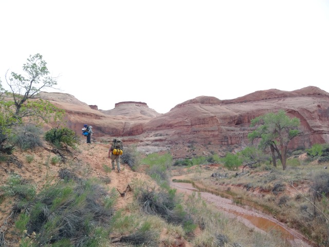
When the guys got back, we headed up the White Roost. This is near the mouth of the White Roost and you can see Derek making his way up canyon.
enlarge 289KB, 1024x768 411 2014 Robbers Roost 421-bill Going up the White Roost.
enlarge 347KB, 1024x768 412 2014 Robbers Roost 422-bill Fred at a narrow section of the canyon.
enlarge 309KB, 1024x768 413 2014 Robbers Roost 423-bill A reflecting pool.
enlarge 338KB, 1024x768 414 2014 Robbers Roost 424-bill The upper end of the pool.
When we got to the exit. We had lunch. Shelby, David, and Derek went up canyon to explore one of the White Roost slots. Austin, Fred, and I waited till they got back.
enlarge 275KB, 768x1024 423 2014 Robbers Roost 432a-austin Waiting for they guys to get back from exploring the White Roost Slot.
The weather was deteriorating - the wind was kicking up and the skies were threatening, so a collective decision was made (I was out on a dump run) to forgo camping another night and go out that evening instead. They already had redistributed my gear and were ready to go.
All I had to carry was my little day pack (little blue pack to the left of my elbow).
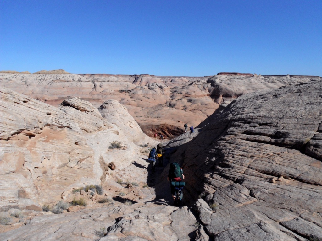
The upper end of the third ramp - Fred has already made the switchback to the fourth ramp.
enlarge 254KB, 1024x768 433 2014 Robbers Roost 444-bill Looking back down the third ramp.
enlarge 256KB, 1024x768 434 2014 Robbers Roost 446-bill The fourth ramp leads to the lower canyon rim - you can see the switchback below.
enlarge 138KB, 1152x647 435 2014 Robbers Roost 447-bill Fred on the slickrock above the lower rim. A cairn is to his right.
enlarge 76.67MB, 1152x648 Download MPEG4 436 2014 Robbers Roost Vid 012.mp4 VIDEO - Click Photo to View. Panoramic video from atop the lower rim of the White Roost.
enlarge 158KB, 1152x647 437 2014 Robbers Roost 449-bill Looking east - you can barely make out the canyon from on top.
enlarge 179KB, 1152x647 438 2014 Robbers Roost 450-bill Looking back toward where we climbed up to the rim.
This shows where we came in - between the two conical domes to the right of the photo and down the steep slickrock. On our way out we are taking a less steep alternative.
enlarge 186KB, 1152x647 440 2014 Robbers Roost 454-bill Looking at the erosion gully to the right of where we came down.
Rather than go over the last slickrock hill, I traversed over to the left to reach the trail that we had come down on. When I got to it, I could see Shelby and Austin just going over hill on the horizon.
enlarge 150KB, 1024x768 447 2014 Robbers Roost 461-bill Telephoto of Shelby and Austin.
When we got out and on our way, we bid goodbye to Fred for his trip south. We headed north and had excellent burgers, etc. at Rays Tavern in Green River. Fortunately, we were able to get room reservations in Tremonton at the Sandman even though we got there about 1 or 2 in the morning.
We found this car the next morning outside of the Tremonton Dennys. I assume he was heading to or from Cliven Bundy's ranch in Nevada! Although this isn't the type of vehicle that one envisages for that.
Making our way home we made our way through the rest of Utah and all the way across Idaho without making a gas stop. Aways into Oregon, Shelby stated that he needed to make a gas stop at the next exit (Farewell Bend). I told him that the Farewell Bend Gas station (shown here) was closed and that there weren't any stations till Baker.
Another view of the infamous Farewell Bend Truck Stop. We had stopped here on our first Wyoming trip in 1998 and had the absolute worst dinner I have ever had in a restaurant. It's a wonder this place stayed open as long as it had.
We backtracked a little ways (13 miles on side roads) to Weiser, Idaho and got gas and had pizza at Idaho Pizza. Very good pizza.
It was a long drive home, hitting a red box every couple of hours listening to movies - Anchorman 2, the Wolf of Wall street, etc. (Not to mention the Mighty Boosh)