Don't Tread on Me! - Canyon Resident We Met on Trail
Attendees: Bill Mooseker, Fred Stong, Joel Fuller, Nick McMahan
This was the 12th springtime trip to Utah's Canyons for the Troop 24 Kickass Trekkers. There were only four of us for this trip. I've often wondered about going to Dark Canyon, but the trailheads are above 8000 feet and usually are snow covered when we usually make our trips.
This year we were making the trip in mid May, and the access roads were open. It takes two days to reach the trailhead from Lynnwood. After a long, long first day we overnight in Tremonton, Utah (about a 700 mile day)
The next day was much shorter and we hoped to meet Fred at the National Bridges National Monument Headquarters in mid afternoon, but it took us longer as we were wandering all over Price, UT to find an auto parts store to get some fuses to fix the taillights on the Gray Ghost.
It was late afternoon when we pulled into the parking lot at National Bridges NM. We sorted out our gear and got our packs ready and transferred them to Fred's truck. Taking off we made our way on a fairly good dirt road up and through the Bear's Ears. We dropped the car off at the Peavine Trailhead and all of us piled into Fred's Truck for the long drive to the Big Notch Trailhead.
The Dark Canyon Wilderness is very remote, and we did not see many people during our trip. It was quite different from our other canyon treks due to the higher elevation. Water was a concern as 2012 was a very dry year, and any visitor should consult local sources for the latest information before making a trip here.
In order to locate where the photos in the album were taken i've used the online map tool, Acme Mapper. This is a superb application which gives you linked topo and aerial photo (google) maps. I used to use some Bing maps but those didn't work anymore, so I've converted them to Google Maps.
Note that photo titles ending in "Joel" are by Joel Fuller. The rest are mine.
Troop 24 Kickass Trekkers Backpacking Trip
-Cascade Bill Mooseker
Date(s): May 15 -19, 2012. Album by Cascade Bill. 1 - 214 of 214 Total. 11493 Visits.
To get the plugin just Google "videolan" or CLICK HERE FOR DOWNLOAD for Windows. There is a MAC version as well. Disable the Quicktime plugin if you use Videolan. To view fullscreen videos click the icon on the top right of the video when it starts playing.
If you want to save photos to your computer, click the box under the thumbnails of the photos you want to download. Then click the "Download" button at the top of the album. Pick the size you'd like to download (Original is best)and the photos will be downloaded to a folder of your choice.
enlarge 591KB, 1024x768 2 DC2012-001-IMG 0563 Fred, Joel, and Nick - Near the start of the trail at the Big Notch Trailhead.
After a long drive from Tremonton, we met Fred at the Natural Bridges NM parking lot. After packing up our packs and getting our gear in order, we took off on a rough road up through the Bears Ears.
enlarge 551KB, 1024x768 3 DC2012-002-IMG 0564 Nick, Bill, and Joel at the Notch Trailhead, heading down into Dark Canyon. The Big Notch Trailhead is located HERE
enlarge 394KB, 1024x768 4 DC2012-003-IMG 0565 The trail drops sharply and we were soon down on the valley floor.
enlarge 465KB, 1024x768 5 DC2012-004-IMG 0566 The trail crosses grassy flats, dotted with aspens and evergreens.
enlarge 182KB, 1024x768 6 DC2012-005-IMG 0567 Heading down the trail. When you notice a faint fork in the trail head to the left to avoid a big gully which opens up and will leave you stranded. If you see a big dropoff to your left head back to go down the other side close to the hill on the south side of the canyon.
enlarge 372KB, 1024x678 7 DC2012-006-2012-05-15 at 17-48-36-Joel Rock formation across the canyon - the sun is dropping fast.
enlarge 288KB, 1024x678 8 DC2012-007-2012-05-15 at 17-52-49-Joel Nick, Bill, and Fred - the sun is almost down and we start looking for a camp spot.
enlarge 312KB, 1024x678 9 DC2012-008-2012-05-15 at 17-53-47-Joel "Canyon" Bill??
enlarge 425KB, 1024x768 10 DC2012-009-IMG 0568 Here you can see the "Gully" - it's deep with steep sides - we are on the south side.
enlarge 84.65MB, 1024x682 11 DarkCanyon01.mp4 VIDEO - Click Photo to View Heading down the Canyon as the sun sets.
enlarge 277KB, 1024x768 12 DC2012-010-IMG 0571 Rock formation across from our camp site - you can the the Gully in between.
enlarge 340KB, 1024x678 13 DC2012-011-2012-05-15 at 20-27-57-Joel Joel - trying his hand at star photography. Do you see the meteor he caught. Enlarge for best view.
enlarge 260KB, 1024x678 14 DC2012-012-2012-05-15 at 20-39-51-Joel Another star shot.
enlarge 496KB, 1024x768 15 DC2012-013-IMG 0572 Nick, Joel, and fred on our first morning. It was a great spot to camp and we were lucky that we didn't go much further as we were hiking down the wet and muddy Gully bottom for a long time.
enlarge 481KB, 1024x768 16 DC2012-014-IMG 0573 Fred and my tents. Just beyond my tent the trail dips down into and crosses the gully to the other side. Our Camp was located HERE
enlarge 400KB, 1024x768 17 DC2012-015-IMG 0574 Breakfast on a chilly morning.
enlarge 454KB, 1024x768 18 DC2012-016-IMG 0575 Looking down into the wash from our camp. You can see the trail climbing up the other side on a sandy slope. There was a little water in the wash here.
enlarge 372KB, 1024x768 19 DC2012-017-IMG 0576 Beautiful flower along the way - I couldn't identify it but you don't have to know what it is to enjoy it.
enlarge 288KB, 1024x768 20 DC2012-018-IMG 0577 Back on top of the vally floor on the north side of the gully heading down canyon.
enlarge 400KB, 1024x768 21 DC2012-019-IMG 0578 The rocks are similar to our other canyon hikes, but the evergreens are not. After a while we came to a point where we had to descend down into the gully wash again. There was a trail up the other side so we took it only to find out that we were just on a peninsula between another gully coming down a side canyon. Looking down we could see a trail going down the wash. For Location: CLICK HERE
enlarge 481KB, 1024x768 22 DC2012-020-IMG 0579 Fred and I decided to go back down and head down the wash where we saw the trail. Nick and Joel decided to drop down into the gully coming down the side canyon. Not the most pleasant hiking as we had to contend with brush, mud, and water in the wash. Eventually, Fred and I stopped for a break where we found a trail up out of the wash. Nick went up to investigate. I think that this is located HERE
enlarge 51.09MB, 1024x682 23 DarkCanyon02.mp4 VIDEO - Click Photo to View Fred and Joel, waiting for Nick to tell us if it was a go or not. Our map showed that the trail up out of the wash was further back, but we never found it. After looking around, Nick came back and told us that there was another side canyon gully blocking the way, so we decided to keep on going down the wash.
enlarge 465KB, 1024x768 24 DC2012-021-IMG 0581 A short while later we found another trail up the side - this is the view from the top. Since a cairn marks the spot we were pretty confident that we were on the right path.
enlarge 413KB, 1024x768 25 DC2012-022-IMG 0582 Looking down canyon from the top of the trail to the bluff. I think that this is located HERE
enlarge 327KB, 1024x678 26 DC2012-023-2012-05-16 at 10-23-02-Joel The trail crossed the level valley floor headed towards this interesting rock formation.
enlarge 426KB, 678x1024 27 DC2012-024-2012-05-16 at 10-26-35-Joel When we got near the rocks we could see that we had to cross another deep gully from a side canyon on the north side. This was Drift Canyon, although I didn't realize it at the time and I thought that Drift was further down canyon.
enlarge 446KB, 1024x768 28 DC2012-025-IMG 0583 Looking down into the wash at Drift Canyon and back up canyon where we had come down (we had crossed the gully and climbed back up to the valley floor). You can see the steep trail down the side of the gully and that there was a little water Drift Canyon.
enlarge 286KB, 1024x768 29 DC2012-026-IMG 0584 Another view looking up canyon. The wash crossing is located HERE
enlarge 355KB, 1024x678 30 DC2012-027-2012-05-16 at 10-33-06-Joel Looking across to the rock formations on the other side of Drift. You can see Nick if you look closely.
enlarge 405KB, 678x1024 31 DC2012-028-2012-05-16 at 10-37-52-Joel Bill hiking through the sage brush.
enlarge 327KB, 678x1024 32 DC2012-029-2012-05-16 at 10-36-54-Joel Close up view of the rock formation at the mouth of Drift Canyon.
enlarge 366KB, 678x1024 33 DC2012-030-2012-05-16 at 10-37-20-Joel Fred and Bill.
enlarge 280KB, 768x1024 34 DC2012-031-IMG 0585 Fred rounding the rock at the mouth of Drift.
enlarge 388KB, 1024x768 35 DC2012-032-IMG 0586 Joel and Nick at the mouth of Drift Canyon.
enlarge 397KB, 1024x768 36 DC2012-033-IMG 0587 After rounding the rocky point at the mouth of Drift, the trail entered a wooded basin - this view is looking back up canyon.
enlarge 507KB, 1024x768 37 DC2012-034-IMG 0588 Fred at some of the Ponderosa pines in the basin - very pleasant spot.
enlarge 406KB, 1024x768 38 DC2012-035-IMG 0589 Fred
enlarge 401KB, 1024x768 39 DC2012-036-IMG 0590 Bill
enlarge 390KB, 768x1024 40 DC2012-037-IMG 0591 I'm gettin too old for this!
enlarge 376KB, 1024x768 41 DC2012-038-IMG 0592 Rounding another knob, we find rocky cliffs surrounding the next little basin - as we walked by, Joel spotted a ruin in the cliff above. Enlarge the photo and see if you can find it.
enlarge 391KB, 1024x768 42 DC2012-039-IMG 0593 Telephoto view of ruin. I don't know how they got up there. Enlarge for best view.
enlarge 405KB, 1024x768 43 DC2012-040-IMG 0594 Another view.
enlarge 374KB, 1024x768 44 DC2012-041-IMG 0595 After passing the basin with the cliff ruin, the next basin (or more correctly a "box canyon" harking back to my Gene Autry and Roy Rogers terminology) was a large meadowed one. We left the trail to find a good spot for lunch (as seen here). After lunch Nick and Joel took off to explore the basin. As Fred and I waited, the sky clouded up and we had a short period of wind and rain.
enlarge 332KB, 1024x768 45 DC2012-042-IMG 0596 This is the rock buttress at the south end of the box canyon where we had lunch. You can see what looks to be an alcove. Nick and Joel went on down the trail while Fred and I went up to explore the alcove.
enlarge 295KB, 1024x768 46 DC2012-043-IMG 0597 Getting a closer view of the alcove. We dropped our packs and went up to explore.
enlarge 399KB, 1024x768 47 DC2012-044-IMG 0598 In the alcove are a few random rocks - remnants of a ruin? probably not.
enlarge 292KB, 1024x768 48 DC2012-045-IMG 0599 Looking back up canyon from the alcove. This box canyon is located HERE
enlarge 403KB, 1024x768 49 DC2012-046-IMG 0600 Hiking down from the alcove, I was holding the camera and I accidently snapped this photo. Fred and I decided that we would explore the basin.
enlarge 459KB, 1024x768 50 DC2012-047-IMG 0601 Desert paintbrush - seems "stringier" than those in Cascade meadows.
enlarge 359KB, 1024x768 51 DC2012-048-IMG 0602 Telephoto looking back to the up-canyon end of the meadow.
enlarge 288KB, 1024x768 52 DC2012-049-IMG 0603 Fred heading to the upper end of the meadow.
enlarge 296KB, 1024x768 53 DC2012-050-IMG 0604 Fred climbed up the rocks at the head of the basin and got this photo.
enlarge 53.57MB, 1024x682 54 DarkCanyon03.mp4 VIDEO - Click Photo to View Video taken by Fred as he climbed up the cliff at the head of the meadow.
enlarge 319KB, 1024x768 55 DC2012-051-IMG 0605 View from the cliff looking back toward the main canyon.
enlarge 466KB, 1024x768 56 DC2012-052-IMG 0606 View looking back along the cliffs surrounding the meadow.
enlarge 422KB, 1024x768 57 DC2012-053-IMG 0607 Another view.
enlarge 241KB, 1024x768 58 DC2012-054-IMG 0609 After our side trip, we returned to our packs and headed back down canyon. Rounding the Rocky point that had the alcove, we traversed another small basin. Rounding the bluff at the end of the basin, we were surprised when we found that we had arrived at the Scorup Cabin at the mouth of Horse Canyon. This is a view looking down canyon at the mouth of Horse Canyon.
enlarge 432KB, 1024x768 59 DC2012-055-IMG 0610 Fred sitting on the steps of the Scorup Cabin, reading the history of Al Scorup a copy of which can be found online: CLICK HERE. We camped at the campsite Located Here.
enlarge 347KB, 1024x678 60 DC2012-056-2012-05-16 at 12-38-14-Joel The Scorup Cabin. Photos of the interior of the cabin can be found HERE The cabin was originally located in Rig Canyon (1927) where it was used as a base for an oil drilling operation until it was moved here in 1930 for the summer headquarters of the Dugout Ranch Cattle cowboys. In 1970 the cabin was turned over to the Forest Service.
enlarge 320KB, 1024x678 61 DC2012-057-2012-05-16 at 15-02-31-Joel Nick heading up Horse Canyon - Nick and Joel took an afternoon sidetrip a ways up Horse.
enlarge 276KB, 1024x678 62 DC2012-059-2012-05-16 at 15-04-01-Joel Horse Canyon is wide at the mouth with a big meadow. Fred was telling me about the book "Dark Canyon" by Louis L'amor with it's tales of rustlers hiding cattle in it's side canyons. Horse Canyon does appear to be a place to hide a bunch of steers.
enlarge 273KB, 1024x678 63 DC2012-061-2012-05-16 at 15-04-18-Joel Nick in Horse Canyon.
enlarge 369KB, 1024x678 64 DC2012-063-2012-05-16 at 15-31-11-Joel Claret Cup cactus flowers in Horse Canyon.
enlarge 218KB, 1024x678 65 DC2012-064-2012-05-16 at 15-31-45-Joel Close up of Claret Cup flowers.
enlarge 442KB, 678x1024 66 DC2012-065-2012-05-16 at 15-32-15-Joel Group of Claret cup flowers.
enlarge 293KB, 1024x678 67 DC2012-066-2012-05-16 at 15-34-26-Joel Nick doing some "bouldering" in Horse Canyon.
enlarge 300KB, 1024x678 68 DC2012-067-2012-05-16 at 15-34-42-Joel Note the interesting hoodoo's in the background.
enlarge 342KB, 1024x768 69 DC2012-068-IMG 0611 Looking up Horse Canyon from it's mouth.
enlarge 335KB, 1024x768 70 DC2012-069-IMG 0612 Fred in Horse Canyon.
enlarge 335KB, 1024x768 71 DC2012-070-IMG 0613 View of Horse Canyon.
enlarge 557KB, 1024x768 72 DC2012-071-IMG 0614 Cattlemen's shed near Scorup Cabin - filled with interesting junk.
enlarge 289KB, 1024x768 74 DC2012-073-IMG 0616 View from near the "waterfall" below Scorup Cabin.
enlarge 404KB, 1024x768 75 DC2012-074-IMG 0617 Waterfall at Scorup Cabin - there was some seepage but no water coming down the wash. There was a big pour-off pool below the falls.
Off to the right of this picture there was a pipe (3/4" maybe) jutting out from the hill dripping water. We would put our big pot under the drip and come back an hour or so later to transfer it to our 5 gal jugs.
enlarge 365KB, 678x1024 76 DC2012-075-2012-05-17 at 08-55-17-Joel Looking down canyon from the "falls".
enlarge 406KB, 1024x768 77 DC2012-076-IMG 0618 Fred - Heading out on our 3rd day. This is really an impressive view.
enlarge 427KB, 1024x768 78 DC2012-077-IMG 0619 The Old Man.
enlarge 429KB, 1024x768 79 DC2012-078-IMG 0620 Another view.
enlarge 374KB, 1024x768 80 DC2012-079-IMG 0621 Looking back towards the falls. It was very swampy here and we had to make detours frequently to avoid going over out boot tops.
enlarge 300KB, 768x1024 81 DC2012-080-IMG 0622 Hoodoo down canyon from Horse Canyon.
enlarge 418KB, 1024x768 82 DC2012-081-IMG 0623 Further down the canyon, the wash dries up. This is another "Falls" as noted on the topo map. The road (accessible by ATV from Peavine Canyon) winds around this spot. This Pour-off is located Here
enlarge 310KB, 1024x768 83 DC2012-082-IMG 0624 Looking back up canyon. You can see the road as it comes down the bank into the wash from a side canyon.
enlarge 336KB, 1024x678 84 DC2012-083-2012-05-17 at 10-37-47-Joel Another bank of phlox flowers.
enlarge 386KB, 1024x768 85 DC2012-084-IMG 0625 Horned toad - the first I've seen.
enlarge 391KB, 1024x768 86 DC2012-085-IMG 0626 When we got to the mouth of Peavine Canyon, we met this group of hikers who are members of a seniors bicycle club who were doing the Woodenshoe - Peavine Canyon loop trip. It's all relative when I say senior as they were all junior to me. They told us that other than where we were, there was no water available until the spring just up canyon from the Mouth of Trail Canyon. We had planned to camp somewhere near Rig Canyon, but with no water our options were either staying put or hiking all the way down to the next water. As it was still early in the day, we decided to hike all the way down the canyon.
enlarge 304KB, 1024x768 87 DC2012-086-IMG 0627 Looking up Peavine Canyon. You can see the "Seniors" heading up the trail.
enlarge 325KB, 1024x678 88 DC2012-087-2012-05-17 at 12-01-06 (2)-Joel Nick at the mouth of Peavine - we took a break for lunch here.
enlarge 477KB, 1024x768 89 DC2012-088-IMG 0628 Nick looking for a little shade!
enlarge 324KB, 1024x678 90 DC2012-089-2012-05-17 at 10-44-20-Joel If you look closely you can see the Peavine Arch in the rocks above.
enlarge 357KB, 1024x678 91 DC2012-090-2012-05-17 at 12-01-21-Joel A view of the arch.
enlarge 388KB, 1024x768 92 DC2012-091-IMG 0629 Another view.
enlarge 182KB, 1024x678 93 DC2012-092-2012-05-17 at 12-12-30-Joel Close up of Phlox flowers.
enlarge 365KB, 1024x768 94 DC2012-093-IMG 0630 Another view looking towards Peavine Arch from the wash at the mouth of Peavine Canyon.
enlarge 367KB, 1024x768 95 DC2012-094-IMG 0631 On our way down to Rig Canyon - this shot is looking back up canyon to Steamboat Point,which is the peak dividing Dark (which goes to the left) and Peavine (which goes to the right). The path here is the Peavine-Rig Corridor which is a strip in the wilderness that allows ATV access.
enlarge 241KB, 1024x768 96 DC2012-095-IMG 0632 Joel & Nick ahead on the way to Rig Canyon.
enlarge 373KB, 1024x768 97 DC2012-096-IMG 0633 At the mouth of Rig Canyon, the ATV track turns left and heads up Rig Canyon. The backpacker trail (no vehicles) turns right for a few hundred yards and then heads back down Dark Canyon. This photo shows Fred along the stretch between Rig Canyon and Poison Canyon.
enlarge 517KB, 1024x768 98 DC2012-097-IMG 0634 Some flowers along the way.
enlarge 295KB, 1024x768 99 DC2012-098-IMG 0635 Almost to the mouth of Poison Canyon.
enlarge 322KB, 1024x768 100 DC2012-099-IMG 0636 Now heading down the main canyon after the junction with Poison Canyon - Dark Canyon is a broad valley now with imposing buttresses along it's length. The wash is to the left as the trail shortcuts a loop in the wash - note that the headland above is the same one as in the previous picture.
enlarge 351KB, 1024x768 101 DC2012-100-IMG 0637 This one faked me out - I thought we had reached the big loop that the trail shortcuts, but this is just one of the many side canyons. We still had a long way to go.
For location of Photo: CLICK HERE. If you put the coordinates into Google Earth, you get the view shown in the photo when you switch to "Ground View".
enlarge 324KB, 1024x768 102 DC2012-101-IMG 0638end After a while the following amphitheater massif comes into view - It would take a long time to get past it. The trail is sometimes in the wash and then it will climb up on the banks as we go around loops and bends.
enlarge 383KB, 678x1024 103 DC2012-102-2012-05-17 at 15-31-36-Joel A close up view of the Amphitheater. Very Scenic, but strange that it doesn't have a name.
enlarge 311KB, 1024x678 104 DC2012-103-2012-05-17 at 16-14-04-Joel Joel's photo of some Cryptobiotic Soil along the way. You're not supposed to walk on this as it destroy's the colony.
enlarge 277KB, 678x1024 105 DC2012-104-2012-05-17 at 16-14-23-Joel Another shot.
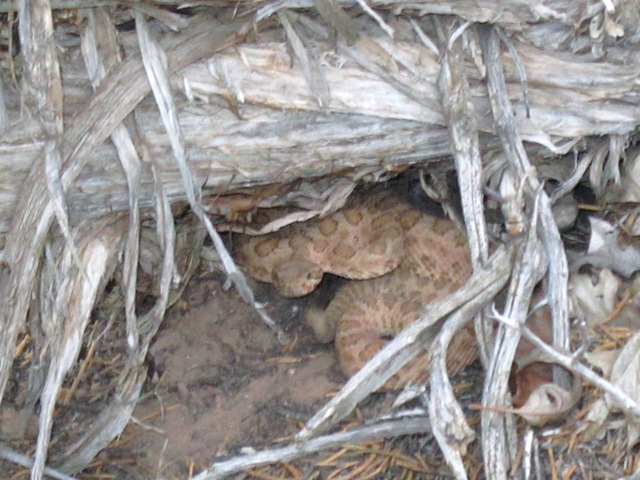
enlarge 282KB, 1024x768 106 DC2012-105-IMG 0639 This little guy was laying astride the trail when we came by. He scurried into this snug hiding place, where he was shaking his rattle very vigorously.
enlarge 28.82MB, 1024x682 107 DarkCanyon04.mp4 VIDEO - Click Photo to View Little rattle snake seen along the trail - this is the first one I have seen in my many years of hiking and growing up in Penna.
enlarge 249KB, 1024x768 108 DC2012-106-IMG 0641 Right next to the rattlesnake was this birdnest - sorry for the focus.
enlarge 356KB, 1024x768 109 DC2012-107-IMG 0642 We finally reached the big bend loop that the trail short circuits by going actoss the headland between the loop. You can see Nick and Joel already down in the wash - as you can see we've climbed a fair amount above the wash. The trail switchbacks down through the trees an re-enters the wash.
enlarge 314KB, 1024x768 110 DC2012-108-IMG 0643 For location of the Photo: CLICK HERE.
enlarge 304KB, 1024x768 111 DC2012-109-IMG 0644 View from the headland we crossed over, looking back up the loop we were shortcutting.
enlarge 170KB, 1024x678 112 DC2012-110-2012-05-17 at 20-02-36-Joel Joel got this shot of Nick at night at our campfire in our camp. It was a long, long day and I was too tired to take any pictures. The spring fed water in the wash was really a welcome sight.
enlarge 80KB, 1024x678 113 DC2012-111-2012-05-17 at 20-03-07-Joel For location of our camp CLICK HERE.
enlarge 464KB, 678x1024 114 DC2012-112-2012-05-18 at 07-11-40-Joel Day 4: In the morning Joel and Nick climbed up to this point near our camp. Actually, the point is on the finger of land that the wash loops around. We found that there was a trail across the headland that we missed as we were coming down the canyon.
enlarge 397KB, 1024x678 115 DC2012-113-2012-05-18 at 07-12-16-Joel Joel about to roll a rock over the edge. For location of this point CLICK HERE.
enlarge 450KB, 1024x768 116 DC2012-114-IMG 0645 Heading back up canyon (retracing our Day 3 hike) we see these landmarks as the trail switches in and out of the wash.
enlarge 649KB, 1024x768 117 DC2012-115-IMG 0646
enlarge 389KB, 1024x768 118 DC2012-116-IMG 0647 It was a much brighter and sunnier day as we climbed back over the headland shortcutting the big loop in the wash.
enlarge 499KB, 1024x768 119 DC2012-117-IMG 0648 Fred on the trail over the headland.
enlarge 344KB, 1024x768 120 DC2012-118-IMG 0649 Hiking along the bank of the wash with this headland as a backdrop.
enlarge 328KB, 1024x768 121 DC2012-119-IMG 0650 Even closer as the wash loops around.
enlarge 343KB, 1024x768 122 DC2012-120-IMG 0651 Back in the wash. Hiking in the wash was more difficult due to the loose sand - you can see the trail on the bank in the background.
enlarge 271KB, 1024x678 123 DC2012-121-2012-05-18 at 09-53-28-Joel Nick and Joel find another Horned Toad.
enlarge 227KB, 678x1024 124 DC2012-122-2012-05-18 at 09-53-38-Joel Lunch?
enlarge 154KB, 1024x678 125 DC2012-123-2012-05-18 at 09-54-12-Joel Close up - He doesn't appear to be amused.
enlarge 270KB, 678x1024 126 DC2012-124-2012-05-18 at 09-54-18-Joel Nick with toad.
enlarge 603KB, 1024x768 127 DC2012-125-IMG 0652 These cactus flowers are comint into bloom. If I were to hazard a guess, I would guess that it is one of THESE or closely related.
enlarge 390KB, 1024x768 128 DC2012-126-IMG 0653 Fred - almost to Poison Canyon.
enlarge 380KB, 1024x768 129 DC2012-127-IMG 0654 Fred - the trail goes through these pines.
enlarge 331KB, 1024x768 130 DC2012-128-IMG 0655 Fred Looking for the trail - we lost it crossing the wash, so we just kept heading up canyon. Unfortunately we were heading up Poison Canyon rather than turning into Dark Canyon. It looked like it was the main canyon. I did see this puny little wash coming in from the right but it didn't look like a major canyon so we just kept going. When we couldn't find any trail or footprints we headed back. I think that hooodoo above is just Poison Canyon giving us the finger.
enlarge 443KB, 1024x768 131 DC2012-129-IMG 0656 After bushwhacking around in the sage brush trying to find the trail, we found this old fencepost - at last a clue that humans had once come this way. All in all we pissed away about an hour.
enlarge 368KB, 1024x768 132 DC2012-130-IMG 0659 Finally we found the right trail - Here Fred takes a self portrait.
enlarge 433KB, 1024x768 133 DC2012-131-IMG 0660 If you look on the Google Satellite map you can see two circles at the mouth of rig canyon - These are corrals of some long gone cattle operation. For location CLICK HERE.
enlarge 91.25MB, 1024x682 134 DarkCanyon05.mp4 VIDEO - Click Photo to View Fred took this video of the Corrals.
enlarge 359KB, 678x1024 135 DC2012-132-2012-05-18 at 12-29-11-Joel Joel got this shot of me as I came up the backpacker trail to meet the ATV road at the mouth of Rig Canyon. The sign says "Wilderness Boundary - No vehicles beyond this point. Violators will be prosecuted."
enlarge 427KB, 1024x768 136 DC2012-133-IMG 0661 Taking a break at Rig Canyon. Joel and Nick were wondering where the hell we had gotten to.
enlarge 460KB, 1024x768 137 DC2012-134-IMG 0662 Nick, Joel, and Bill.
enlarge 328KB, 1024x768 138 DC2012-135-IMG 0663 Heading back towards Peavine Canyon.
enlarge 436KB, 1024x768 139 DC2012-136-IMG 0664 We camped about a hundred yards up Peavine Canyon in a nice developed camp, located HERE.
enlarge 438KB, 1024x768 140 DC2012-137-IMG 0665 Sign at the mouth of Peavine Canyon. Our starting point was at Big Notch on Rd #378.
enlarge 296KB, 1024x768 141 DC2012-138-IMG 0670 After we settled in, Joel and Nick took off to see if they could hike up to Peavine Arch, seen here.
enlarge 338KB, 768x1024 142 DC2012-139-IMG 0669 View of the arch.
enlarge 291KB, 768x1024 143 DC2012-140-IMG 0668 Another view.
enlarge 254KB, 768x1024 144 DC2012-141-IMG 0667 Extreme telephoto (as much as my camera allows) of arch.
enlarge 248KB, 678x1024 145 DC2012-142-2012-05-18 at 14-35-01-Joel The following photos are from Joel and Nick's day hike up to the arch - Here is an old ruin they found along the way.
enlarge 246KB, 1024x678 146 DC2012-143-2012-05-18 at 14-35-08-Joel Nick playing hide and seek.
enlarge 299KB, 1024x678 147 DC2012-144-2012-05-18 at 14-45-20-Joel Another ruin - Steamboat Point across the valley.
enlarge 425KB, 678x1024 148 DC2012-145-2012-05-18 at 14-48-20-Joel Getting closer to the arch.
enlarge 301KB, 678x1024 149 DC2012-146-2012-05-18 at 14-48-31-Joel 2 Nick looking for a route.
enlarge 393KB, 678x1024 150 DC2012-147-2012-05-18 at 15-03-17-Joel They made it - Nick on the other side of the arch.
enlarge 412KB, 678x1024 151 DC2012-148-2012-05-18 at 15-03-25-Joel Note that Nick and Joel are also mountain climbers. For location of the arch CLICK HERE
enlarge 301KB, 678x1024 152 DC2012-149-2012-05-18 at 15-22-42-Joel Slot along the way - These Ponderosa pines have found a home.
enlarge 302KB, 678x1024 153 DC2012-150-2012-05-18 at 15-23-38-Joel Looking out another slot.
enlarge 295KB, 1024x678 154 DC2012-151-2012-05-18 at 15-49-56-Joel Nick on the edge of another precipice.
enlarge 282KB, 1024x678 155 DC2012-152-2012-05-18 at 15-50-06-Joel Walking along the edge - For location, CLICK HERE
enlarge 274KB, 1024x678 156 DC2012-153-2012-05-18 at 15-50-09-Joel Another shot.
enlarge 218KB, 678x1024 157 DC2012-154-2012-05-18 at 15-50-20-Joel Getting close to the monolith.
enlarge 227KB, 1024x678 158 DC2012-155-2012-05-18 at 15-58-28-Joel Joel on top. Looking back up Dark Canyon.
enlarge 298KB, 1024x678 159 DC2012-156-2012-05-18 at 15-58-33-Joel Another view.
enlarge 342KB, 1024x678 160 DC2012-157-2012-05-18 at 15-59-43-Joel Joel (why are his shorts pulled up?) from the same spot looking back to the monolith seen in previous photos.
enlarge 272KB, 1024x678 161 DC2012-158-2012-05-18 at 16-11-26-Joel Nick looking over the edge - Steamboat Point is opposite.
enlarge 253KB, 1024x678 162 DC2012-159-2012-05-18 at 16-11-30-Joel Another view.
enlarge 307KB, 1024x678 163 DC2012-160-2012-05-18 at 16-12-13-Joel Nick on the Edge.
enlarge 326KB, 678x1024 164 DC2012-161-2012-05-18 at 16-12-21-Joel View of the Cliff - that's quite a drop.
enlarge 328KB, 1024x678 165 DC2012-162-2012-05-18 at 16-13-32-Joel Joel at the same spot.
enlarge 390KB, 678x1024 166 DC2012-163-2012-05-18 at 16-13-50-Joel Joel - I think that this is where he is sitting: CLICK HERE
enlarge 307KB, 1024x678 167 DC2012-164-2012-05-18 at 16-34-02-Joel Working their way back down.
enlarge 262KB, 1024x678 168 DC2012-165-2012-05-18 at 16-34-16-Joel Now that looks scary to me.
enlarge 310KB, 1024x678 169 DC2012-166-2012-05-18 at 16-34-26-Joel Looking back through the slot over to Steamboat Point.
enlarge 275KB, 678x1024 170 DC2012-167-2012-05-18 at 16-34-50-Joel View from Slot - I think that this slot is located HERE. The slot leads back to the Arch.
enlarge 314KB, 678x1024 171 DC2012-168-2012-05-18 at 17-01-56-Joel Nick having a little fun.
enlarge 304KB, 678x1024 172 DC2012-169-2012-05-18 at 17-02-34-Joel Doing a little bridging.
enlarge 481KB, 1024x768 173 DC2012-170-IMG 0671 DAY 5: Getting ready to leave camp.
enlarge 469KB, 1024x768 174 DC2012-171-IMG 0672 Fred squeezing the air out of his Thermarest. Enlarge photo to see the elaborate fireplace.
enlarge 449KB, 1024x768 175 DC2012-172-IMG 0673 Nick and Joel pumping water for the day.
enlarge 346KB, 1024x768 176 DC2012-173-IMG 0674 We met John, a Doctor for the Hopi, who was doing the Woodenshoe-Peavine Loop. He gave Nick and Joel, two 16 ounch cans of Coors, which made them fans for life.
enlarge 439KB, 1024x768 177 DC2012-174-IMG 0675 Heading up Peavine.
enlarge 322KB, 1024x768 178 DC2012-175-IMG 0676 Along the way we met several AWD convoys headed out for the weekend - The road appears to be fairly heavilly travelled. If you're not the first vehicle in the convoy, you're eating a lot of dust.
enlarge 307KB, 1024x768 180 DC2012-177-IMG 0678 Lower Peavine is a wide open valley. We passed several grassy meadows, such as those to the left.
enlarge 285KB, 1024x678 181 DC2012-178-2012-05-19 at 08-31-56-Joel We found these bones along the way.
enlarge 324KB, 1024x678 182 DC2012-179-2012-05-19 at 08-32-10-Joel Joel having a little fun.
enlarge 314KB, 678x1024 183 DC2012-180-2012-05-19 at 08-32-17-Joel No, Joel did not carry these out.
enlarge 242KB, 1024x678 184 DC2012-181-2012-05-19 at 08-32-31-Joel This looks like some kind of Dragonbone armor from Skyrim.
enlarge 262KB, 1024x678 185 DC2012-182-2012-05-19 at 08-32-50-Joel Bones.
enlarge 471KB, 1024x768 186 DC2012-183-IMG 0679 Fred Taking a Break.
enlarge 420KB, 1024x768 187 DC2012-184-IMG 0680 Hiking up the road.
enlarge 442KB, 1024x768 188 DC2012-185-IMG 0681 Joel relaxing with a book. We stopped for lunch where the backpacker trail up Peavine split off from the ATV road, which leaves Peavine Canyon and goes up Kigala Canyon to Little Notch.
enlarge 422KB, 1024x768 189 DC2012-186-IMG 0682 Nick - (When you're young and fit you can take a 500 page hardcover book along). Note the Bearcans - we used them to keep the food organized and as camp chairs.
enlarge 373KB, 1024x768 190 DC2012-187-IMG 0683 Trail marker for the Junction - we were heading up the Peavine Trail. The Junction is located HERE
enlarge 302KB, 1024x768 191 DC2012-188-IMG 0684 Fred heading up the Peavine trail.
enlarge 380KB, 1024x768 192 DC2012-189-IMG 0685 Fred crossing a sage brush meadow - It looks like the canyon is closing in a bit.
enlarge 614KB, 1024x768 193 DC2012-190-IMG 0686 Fred - Leaving the open sage we enter an aspen forest. Very pleasant hiking.
enlarge 499KB, 1024x768 194 DC2012-191-IMG 0687 Very pretty along this stretch.
enlarge 502KB, 1024x768 195 DC2012-192-IMG 0688 Joel and Nick waiting for Fred and I at the water trough.
enlarge 406KB, 1024x768 196 DC2012-193-IMG 0689 Fred inspecting the water trough.
enlarge 413KB, 1024x768 197 DC2012-194-IMG 0690 We were going to camp here but there weren't any really good spots to camp so we decided to keep going.
enlarge 33.17MB, 1024x682 198 DarkCanyon06.mp4 VIDEO - Click Photo to View There isn't much flow here!
enlarge 529KB, 1024x768 199 DC2012-195-IMG 0694 Fred going up the trail.
enlarge 29.20MB, 1024x682 200 DarkCanyon07.mp4 VIDEO - Click Photo to View Fred heading up the trail - it almost seems that we are somewhere in the Pasayten.
enlarge 509KB, 1024x768 201 DC2012-196-IMG 0695 Joel & Nick - after giving up on camping at the water trough, we hoped to find a camp in upper Peavine where the creek would provide water. We got there and it was very pleasant, but there were no camp spots. We decided to hike out to the car and spend the night in Blanding.
enlarge 356KB, 1024x768 202 DC2012-197-IMG 0696 The guys headed out and soon left me behind. This is the boundary of the Dark Canyon Wilderness.
enlarge 503KB, 1024x768 203 DC2012-198-IMG 0697 Some Lupine meadows.
enlarge 451KB, 678x1024 204 DC2012-200-2012-05-19 at 16-23-22-Joel Joel's photo of the Sun through the trees.
enlarge 285KB, 678x1024 205 DC2012-201-2012-05-19 at 16-25-05-Joel Another artistic shot.
enlarge 299KB, 678x1024 206 DC2012-202-2012-05-19 at 16-25-13-Joel Fred hiking through the aspens - the last 1/2 mile was really steep gaining 500-600 feet.
enlarge 542KB, 1024x678 207 DC2012-203-2012-05-19 at 16-25-22-Joel The sun is setting - we've had a long day.
enlarge 315KB, 1024x768 208 DC2012-199-IMG 0698 The trail marker near the trailhead.
enlarge 473KB, 1024x768 209 DC2012-204-IMG 0699 I'm finally in sight of the car - Joel came down and got my pack. Even with the pack, he could go about three times as fast as I could.
enlarge 458KB, 1024x768 210 DC2012-205-IMG 0700 Going down the trail.
enlarge 477KB, 1024x678 211 DC2012-206-2012-05-19 at 17-10-44-Joel The Sign at the trailhead.
enlarge 345KB, 768x1024 212 DC2012-207-IMG 0701 Enlarge to read.
enlarge 301KB, 1024x768 213 DC2012-208-IMG 0702 Another view.
enlarge 509KB, 1024x768 214 DC2012-209-IMG 0703 Bill and the "Silver Bullet" aka "The Gray Ghost" (1985 Camry). This was the third trip to Utah for it. On the way in we put all our stuff in Fred's truck and left my car here. All we had to do was drive to the Big Notch trailhead. On the way out, we had to drive to Big Notch and return with Fred's Truck. When we got back to the Peavine trailhead it was almost dark. After packing everything up, we headed back through the Bear's Ears, chasing steers down the road. Unfortunately, we got to Blanding just as the last restaurant was closing. We had to settle for a Quik Mart sandwich. The next morning we said our goodbyes to Fred and started on our two day trip back to Lynnwood.