Climbing Out of Grand Gulch via the Government Trail
Our last day on the trail was only about 3 miles from Polly's Canyon to the Government Trailhead, but it included a 500 foot climb up to the rim. The Government Trail starts a short ways down canyon from our camp. As it climbs out or the canyon, the views become ever more spectacular.
After you reach the rim, the trail crosses the mesa leaving all visual evidence that Grand Gulch even exists. With far away views of the Bear's Ears and other tall mesas, we finally reach the stockpond that marks the trailhead. We all piled into Shelby's truck and made our way back to the Kane Gulch Ranger station where we said our goodbyes to Fred and Cindy.
Heading north, we stopped in Blanding for lunch and after dropping Mike and Madison off in Salt Lake, Shelby and I continued on to Mountain Home, Idaho where we found a motel for the night.
Note photo takers are given in the titles under the thumbnails.
Kickass Trekkers on this trip were: Bill Mooseker, Shelby Stong, Mike Stong, Madison Stong, Fred Stong, and Cindy Stong.
The descriptions under the photo thumbnails in the album sometimes contain links to maps or additional information. These are identified by "Blue” text for links. I've also inserted links to Google Maps to show where certain photos in the album were taken or to locate features shown in the photos. Click on the link, close the sidebar, and choose satellite view. Basically, you can then zoom in and out using the mouse wheel or drag the map by clicking and holding.
For panoramic photos, I would recommend clicking on the thumbnail photo to enlarge. View at original size for most detail. The thumbnails do not do justice to petroglyphs and pictographs, so I would recommend enlarging them as well. Please take the time to view the many videos to better experience what it was like to be there.
Troop 24 Kickass Trekkers Backpacking Trip
-Cascade Bill Mooseker
Date(s): May 12. Album by Cascade Bill. 1 - 95 of 95 Total. 505 Visits.
enlarge 521KB, 1024x1022 1 pic&vids
To get the plugin just Google "videolan" or CLICK HERE FOR DOWNLOAD for Windows. There is a MAC version as well. Disable the Quicktime plugin if you use Videolan.
If you want to save photos to your computer, click the box under the thumbnails of the photos you want to download. Then click the "Download" button at the top of the album. Pick the size you'd like to download (Original is best)and the photos will be downloaded to a folder of your choice.
enlarge 180.51MB, 1152x648 Download MPEG4 2 2016 ut may 12 gp001a.mp4 VIDEO - Click Photo to View. Last morning - Water is on to boil for hot chocolate and oatmeal. The sun is showing on the canyon rim.
enlarge 120KB, 1024x768 3 2016-05-12 05-29-56 bill DSC01459 Leaving camp - looking down the Gulch
enlarge 156KB, 1024x768 4 2016-05-12 05-30-16 bill DSC01463 Cindy and Fred - due to the big pool at the mouth of the canyon we had to scramble under the cottonwoods of the camp to cross the stream to avoid wading the pool.
enlarge 186KB, 1024x768 5 2016-05-12 05-31-48 cindy IMG 9379 Bill - ready to head out
enlarge 173KB, 768x1024 6 2016-05-12 05-31-52 cindy IMG 9380 Bill
enlarge 297.48MB, 1152x648 Download MPEG4 7 2016 ut may 12 gp 002.mp4 VIDEO - Click Photo to View. Leaving Polly's Canyon and hiking down the slickrock towards the Gov't Trail.
enlarge 97KB, 1024x768 12 2016-05-12 05-35-32 bill DSC01464 We started up this trail, but I soon realized that it wasn't the right one. Shelby kept going and made his way cross country. The Government Trail was much further down the canyon.
enlarge 155KB, 1024x768 13 2016-05-12 05-37-18 cindy IMG 9385 Heading up the false trail
enlarge 267KB, 1024x768 14 2016-05-12 05-52-34 cindy IMG 9387 We're finally on the right trail.
enlarge 239KB, 1024x768 15 2016-05-12 05-50-34 bill DSC01466 Gaining elevation quickly, the views get better as well.
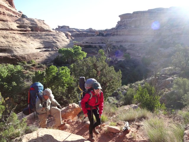
enlarge 182KB, 1024x768 16 2016-05-12 05-50-38 bill DSC01467 Mike and Madison climbing up the trail.
enlarge 186KB, 1024x768 17 2016-05-12 05-54-20 bill DSC01468 Cindy and Fred
enlarge 218KB, 1024x698 18 2016-05-12 05-55-00 bill DSC01469 A Kodak moment
enlarge 254.77MB, 1152x648 Download MPEG4 19 2016 ut may 12 gp 003.mp4 VIDEO - Click Photo to View. Climbing the Gov't Trail - I'm huffing and puffing away as it is a steep trail (Even Mike is huffing a little). This video gives a good sense of what this trail is like.
enlarge 116KB, 1024x768 20 2016-05-12 05-55-18 bill DSC01470 View of Polly's Island across the way. Polly's Island was formed as the water used to flow around it but then cut the current channel that we came down today, leaving the isolated block known as Polly's Island.
enlarge 177KB, 1024x768 21 2016-05-12 05-55-28 bill DSC01471 Ruin just under the rim of Polly's Island.
enlarge 183KB, 768x1024 23 2016-05-12 05-56-40 cindy IMG 9390 Bill getting a photo of Polly's Island.
enlarge 200KB, 1024x768 24 2016-05-12 05-57-00 mike DSCF4525 Bill, Cindy, and Fred climbing up the trail
enlarge 145KB, 768x1024 25 2016-05-12 05-57-08 mike DSCF4527 Looking back up canyon - Our camp was in the cottonwoods in the sunlight at the center of the photo. You can see the slickrock section with the water pools.
enlarge 141KB, 1024x768 26 2016-05-12 05-57-18 mike DSCF4528 Closeup of the ruin on Polly's Island
enlarge 203KB, 768x1024 27 2016-05-12 05-57-24 mike DSCF4529 Cindy and Fred have passed me by.
enlarge 261KB, 1024x768 28 2016-05-12 06-01-16 cindy IMG 9391 Fred getting his breath
enlarge 195KB, 1024x768 29 2016-05-12 06-01-18 cindy IMG 9392 Madison up ahead - soon we'll be in shadow again.
enlarge 232KB, 1024x768 30 2016-05-12 06-01-20 cindy IMG 9393 View looking back up canyon - we've come quite a way so far.
enlarge 154KB, 768x1024 31 2016-05-12 06-02-38 mike DSCF4532 Madison on the trail
enlarge 183KB, 1024x768 32 2016-05-12 06-03-52 mike DSCF4534 Bill making his way slowly up the climb.
enlarge 241KB, 1024x768 33 2016-05-12 06-04-28 cindy IMG 9394 Taking a break on a big ledge - meeting up with Shelby after his cross country climb.
enlarge 153KB, 1024x768 34 2016-05-12 06-04-50 cindy IMG 9395 view along the canyon wall
enlarge 149KB, 1024x768 35 2016-05-12 06-05-58 bill DSC01475 Almost to the same level as the ruin across the way
enlarge 167KB, 1024x768 36 2016-05-12 06-06-08 bill DSC01476 Telephoto view up canyon to bend above Polly's canyon
enlarge 303.79MB, 1152x648 Download MPEG4 37 2016 ut may 12 gp 004.mp4 VIDEO - Click Photo to View. Taking a break at big ledge before forging ahead.
enlarge 163KB, 1024x768 38 2016-05-12 06-06-52 bill DSC01477 Mike & Madison
enlarge 102KB, 1024x768 40 2016-05-12 06-09-26 bill DSC01480 Selfie of the Old Man
enlarge 466.40MB, 1152x648 Download MPEG4 41 2016 ut may 12 gp 005a.mp4 VIDEO - Click Photo to View. Hiking along the trail from the big ledge to just below the rim
enlarge 220KB, 1024x768 42 2016-05-12 06-14-46 bill DSC01481 Yellow evening primrose along the trail
enlarge 212KB, 1024x768 43 2016-05-12 06-14-52 bill DSC01482 Don't know what these white flowers are - look like Phlox but have 4 petals instead of 5.
enlarge 226KB, 1024x768 44 2016-05-12 06-17-46 cindy IMG 9397 Looking across to Polly's Island
enlarge 135KB, 1024x768 45 2016-05-12 06-17-50 cindy IMG 9398 Getting up to the rim
enlarge 178KB, 1024x768 46 2016-05-12 06-17-54 cindy IMG 9399 Here comes Bill
enlarge 115KB, 1024x768 58 2016-05-12 06-31-00 bill DSC01488 Mike & Madison
enlarge 442.34MB, 1152x648 Download MPEG4 59 2016 ut may 12 gp 007.mp4 VIDEO - Click Photo to View. Video showing Madison trying to get cell reception (everyone else had it); Bill arriving at the rim; Last look into the canyon before heading to the trailhead.
enlarge 189KB, 1024x768 60 2016-05-12 06-33-26 cindy IMG 9409 Ready for the last lap
enlarge 142KB, 1024x768 61 2016-05-12 06-33-00 bill DSC01491 Bill
enlarge 112KB, 1024x768 62 2016-05-12 06-33-14 bill DSC01493 Bill at the rim
enlarge 131KB, 1024x768 64 2016-05-12 06-33-54 bill DSC01494 Mike at the rim
enlarge 126KB, 1024x768 65 2016-05-12 06-36-16 mike DSCF4536 Mike got this shot as we left the rim.
enlarge 198KB, 1024x768 66 2016-05-12 06-36-24 mike DSCF4537 Telephoto - note Polly's Island ruin to right of Bill.
enlarge 144KB, 1024x768 67 2016-05-12 06-36-40 - mike DSCF4538 On the Gov't trail - note how quickly the canyons disappear.
enlarge 280KB, 1024x768 68 2016-05-12 06-37-12 cindy IMG 9412 Madison & Shelby -The Windgate and Mossback Buttes in the background.
enlarge 120KB, 1024x768 69 2016-05-12 06-40-00 bill DSC01495 To the north are the Bear's Ears
enlarge 125KB, 1024x768 70 2016-05-12 06-40-54 mike DSCF4539 Telephoto of the Bear's Ears - we drove through them in 2012 for our backpack in Dark Canyon.
enlarge 134KB, 1024x768 71 2016-05-12 06-41-08 mike DSCF4541 Moss Back Butte
enlarge 174KB, 1024x768 72 2016-05-12 06-41-14 mike DSCF4542 Red House Cliffs
enlarge 200KB, 1024x768 73 2016-05-12 06-45-10 cindy IMG 9413 Shelby passes some cryptobiotic soil on top of the mesa. Since these organisms are damaged easily, you avoid walking on them if at all possible.
enlarge 291KB, 768x1024 74 2016-05-12 06-50-42 mike DSCF4544 Yucca plant about to bloom
enlarge 195KB, 768x1024 75 2016-05-12 06-50-48 mike DSCF4545 Close up of yucca blooms
enlarge 138KB, 1024x768 76 2016-05-12 07-01-00 mike DSCF4559 Up ahead are Madison, Cindy, and Shelby
enlarge 161KB, 1024x768 77 2016-05-12 07-00-28 mike DSCF4555 Telephoto view
enlarge 150KB, 768x1024 78 2016-05-12 07-00-42 mike DSCF4557 Another view
enlarge 130KB, 1024x768 80 2016-05-12 07-05-02 mike DSCF4564 Another view
enlarge 73KB, 1152x248 81 2016-05-12 07-16-22 cindy IMG 9414 Panorama view from Gov't trail (enlarge to original size)
enlarge 339KB, 1024x768 82 2016-05-12 07-39-44 cindy IMG 9420 Goodbye to the last primrose on the hike.
enlarge 224KB, 1024x768 83 2016-05-12 07-43-52 cindy IMG 9422 Cindy at the stock pond at the trailhead.
enlarge 205KB, 1024x768 84 2016-05-12 07-43-36 cindy IMG 9421 Cindy at the end of a long hike.
enlarge 118KB, 1024x768 85 2016-05-12 07-43-58 mike DSCF4570 Madison points to the Gov't Trailhead on the map
enlarge 200KB, 1024x768 86 2016-05-12 07-46-30 cindy IMG 9427 1 Our route as shown on the trailhead map (enlarge to show our camps and the route)
enlarge 353KB, 1024x768 87 2016-05-12 07-44-12 cindy IMG 9424 Flowers at the end of the trail
enlarge 279KB, 768x1024 88 2016-05-12 07-45-04 cindy IMG 9425 End of the trail - Shelby's truck.
enlarge 323KB, 1024x768 89 2016-05-12 07-45-26 cindy IMG 9426 Trail sign - 3 miles to the gulch.
enlarge 237KB, 768x1024 90 2016-05-12 07-49-40 madison IMG 6699 Start (or end in our case) of the Gov't trail
enlarge 127KB, 1024x768 91 2016-05-12 07-56-12 cindy IMG 9429 Getting the gear into the truck for the trip back to Kane R.S.
enlarge 124KB, 1024x672 92 2016-05-12 09-19-18 mike DSCF4574 Back at the Ranger Station I do a little bandaging on my blister (it was a big one) that had been slowing me down for the last 3 days.
enlarge 101KB, 768x1024 93 2016-05-12 09-19-32 mike DSCF4577 Not fun
enlarge 130KB, 768x1024 94 mike DSCF4587 We said our goodbyes to Fred & Cindy at the Ranger Station as they were heading south via the Moki Dugway. Here we pass through the notch in Comb Ridge and leave Cedar Mesa country behind. We had a great lunch in Blanding at the Homestead Steakhouse. Heading north we dropped Mike and Madison off in Salt Lake. Shelby and I made it to Mountain Home, Idaho for the night. Then on to Washington the next day.
enlarge 189KB, 1152x643 95 the end-2400px.png CLICK HERE for Previous Album (Day 4) CLICK HERE Back to Grand Gulch 2016 Folder