Our third trip to the Sierras started out at Sonora Pass and ended at Kennedy Meadow.
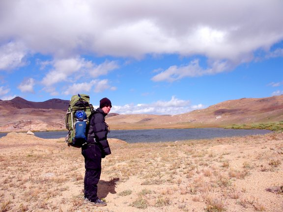
Roger at Upper Emigrant Lake
Photos titles ending in "b" are by Bill, in "a" are by Allison, and in "r" by Roger.
Troop 24 Kickass Trekkers: "The High Adventure Troop" Alumni Backpacking Trip
-Cascade Bill Mooseker
Date(s): September 2006. Album by Cascade Bill. Photos by WHM/ Roger/ Allison. 1 - 143 of 143 Total. 1170 Visits.
enlarge 139KB, 800x600 1 ca06-001r Trailhead at Sonora Pass
enlarge 163KB, 800x600 2 ca06-002r
enlarge 108KB, 800x600 3 ca06-003r
enlarge 171KB, 800x600 4 ca06-004r
enlarge 96KB, 800x600 5 ca06-005r Shelby
enlarge 97KB, 800x600 6 ca06-006r Getting ready to head out - Bill, Allison, Shelby.
enlarge 153KB, 800x600 7 ca06-007b Roger, Shelby, Allison heading out at the start of the trail.
enlarge 139KB, 600x800 8 ca06-008b Checking out the Reader Board.
enlarge 125KB, 800x600 9 ca06-009r The trail traverses the moutain beyond below the snowfields and then turns back to crest the ridge just to the right of the large snowfield at the center.
enlarge 133KB, 600x800 10 ca06-010b Allison climbing the trail just before the crossing of Sardine Creek.
enlarge 183KB, 600x800 11 ca06-011b Looking back at our car parked at Sonora Pass - this was about 35 minutes from the trailhead (as measured by slow old Bill)
enlarge 88KB, 800x598 12 ca06-012a As we get higher, the views expand - this is looking towards the northeast.
enlarge 90KB, 800x598 13 ca06-013a Another view.
enlarge 141KB, 800x598 14 ca06-014a View of the trail as it gets to the eastern side ridge to begin the main traverse.
enlarge 152KB, 800x598 15 ca06-015a Roger and Shelby heading up the trail.
enlarge 90KB, 800x598 16 ca06-016a Still Climbing - view to the east.
enlarge 128KB, 800x598 17 ca06-017a Looking back at the trailhead.
enlarge 129KB, 800x598 18 ca06-018a You can see the trail below as it winds along .
enlarge 104KB, 800x598 19 ca06-019a Roger and Shelby taking a break at the ridge top - about 10800'.
enlarge 80KB, 800x600 20 ca06-020r Roger strikes a pose. You can see Highway 108 below as it climbs up to Sonora Pass fro the east.
enlarge 81KB, 800x600 21 ca06-021r Looking south from our break point.
enlarge 94KB, 800x600 22 ca06-022b After our break at the ridge we head south on a long traverse - Deadman Lake is in the cirque to the right. Leavitt Peak is the peak to the left.
enlarge 105KB, 600x800 23 ca06-023b Shelby, Roger, and Allison heading out along the ridge.
enlarge 108KB, 800x598 24 ca06-031a Looking back along the trail you can see Bill (the white dot) on the trail
enlarge 63KB, 800x600 25 ca06-027r Looking west from the ridge you can see the Deadman Cr valley (location of Route 108).
enlarge 91KB, 800x600 26 ca06-026r Close up of view to west - if you zoom in you can see Rt. 108 at the bottom left of the photo.
enlarge 93KB, 800x600 27 ca06-028r Small tarn to the east of Deadman Lake just below Leavitt Peak.
enlarge 99KB, 800x600 28 ca06-029r Another view of the small tarn
enlarge 91KB, 800x600 29 ca06-030r Creek draining the cirque. Deadman Lake is in the cirque at the far right.
enlarge 123KB, 800x600 30 ca06-024b We take a short break at the point the trail swings over to the other side of the ridge. You can see the steep climb to the ridge above Latopie Lake at the center of the photo.
enlarge 95KB, 600x800 31 ca06-025b Close up of ascent to the ridge above Latopie Lake - as it was getting late we decided to camp above the small tarn in the basin just below the ridge in the picture.
enlarge 115KB, 598x800 32 ca06-032a Looking to the east from the point where the trail crosses the ridge.
enlarge 123KB, 800x598 33 ca06-033a Another small tarn that lies to the right of the trail crossing the ridge. We camped here the first night.
enlarge 116KB, 800x598 34 ca06-034a Shelby looking at the pond. The trail crosses the pass at the center of the photo.
enlarge 100KB, 800x598 35 ca06-035a Day 2: The old heart was pumping as we climbed to the pass (+10800') through the ridge. Bill and Shelby are taking in the view from the south side of the ridge.
enlarge 82KB, 800x600 36 ca06-036r Looking down to Koenig Lake and the larger Leavitt Lake (Elev 9556 ft).
enlarge 84KB, 800x598 37 Latopie Lake ca06-037a Koenig Lake below to the left and Latopie Lake to the right.
enlarge 104KB, 800x600 38 Latopie Lake ca06-038b Latopie Lake - the trail traverses to the right and disappears in the snowbank at the upper right. If you zoom the photo you can see it.
enlarge 88KB, 800x600 39 ca06-039r Another view.
enlarge 121KB, 800x600 40 ca06-040r A telephoto of Latopie Lake - you can see some deer at center of the photo near the bottom.
enlarge 101KB, 800x598 41 ca06-041a Leavitt Lake can be reached with a 4 wheel drive. An old mining road continued up and over the ridge near the snowfield at the center of the photo and down the other side. We would join up with that old road much later in the day.
enlarge 93KB, 600x800 42 ca06-042b
enlarge 97KB, 800x598 43 ca06-043a Roger on the trail: After losing the trail in the snowfield, we climbed up a couple of hundred feet and had to make a descent down the the trail as it traversed this desolate basin on the other side of the ridge.
enlarge 111KB, 600x800 44 ca06-044b Hiking along the trail as it traverses on the opposite side of the ridge from Latopie and Leavitt Lakes.
enlarge 89KB, 800x598 45 Leavitt Lake ca06-045a Looking down into Leavitt Lake - you can see the 4 wheel drive road below.
enlarge 69KB, 800x598 46 ca06-046a Shelby at overlook to Leavitt Lake.
enlarge 125KB, 800x598 47 ca06-047a This is where the ridge trail meets the old mining road. You can see Leavitt peak in the far distance. Shelby says we go "That a way!" (someone had made an arrow in the dirt).
enlarge 103KB, 800x600 48 ca06-048r Looking across the valley. You can see Lost Lake and Molo and Kennedy Peaks to the right.
enlarge 65KB, 800x598 49 ca06-049a You can see the old mining road as it switchbacks down into the valley.
enlarge 102KB, 800x600 50 ca06-050b Our route took us along the old mining road up and over the peak to the far right in the picture.
enlarge 58KB, 800x598 51 ca06-051a Looking back along the ridge towards Leavitt Peak. If you zoom you can see the traill traversing the ridge.
enlarge 139KB, 600x800 52 ca06-052b Our camp for the 2nd and 3rd nights was at the head of Kennedy Creek, which has a nice spring. You can see our tents below.
enlarge 187KB, 800x600 53 ca06-053b Close up of our camp. We had expected Eric and Danny to arrive on the 2nd day but they didn't show up. On the third day it got very cold and windy, slowing up Danny and Eric who didn't show up until very late in the day, much to our relief.
enlarge 109KB, 800x600 54 ca06-054b Looking down Kennedy Creek from the spring.
enlarge 145KB, 800x600 55 ca06-055r Camp deer.
enlarge 146KB, 800x600 56 ca06-056r A lot of nice spots in the woods for the deer to hide.
enlarge 194KB, 800x600 57 ca06-057r Some other "wildlife" in the meadows too.
enlarge 167KB, 800x600 58 ca06-058r These critters were pretty wild.
enlarge 189KB, 800x600 59 ca06-059r Roger, be careful, I think that cow is looking for romance.
enlarge 158KB, 800x600 60 ca06-060r A grouse near our camp.
enlarge 132KB, 800x598 62 ca06-062a Whether its a scorpion or a grouse it can't hide from Shelby (this was strictly catch and release).
enlarge 120KB, 800x598 63 ca06-063a Shelby and Danny.
enlarge 106KB, 598x800 64 ca06-064a Shelby and friend.
enlarge 91KB, 800x598 65 ca06-065a Eric at camp.
enlarge 95KB, 800x600 66 ca06-066b Day 4: Starting out on our fourth day, it was bitter cold and very windy. It looks nice but you wouldn't want to hike in it. Our camp was to the right of center.
enlarge 208KB, 800x600 67 ca06-067b Ice, Ice, Baby! This creek was covered in ice.
enlarge 100KB, 800x598 68 ca06-068a Looking back at our camp and the old mining road as it switchbacks down the ridge.
enlarge 148KB, 800x598 69 ca06-069a Telephoto view of our camp.
enlarge 152KB, 800x598 70 ca06-070a Shelby and Eric head up the trail. Bill is further up the trail to the right.
enlarge 103KB, 800x598 71 Kennedy Lake ca06-071a Looking down the valley at Kennedy Lake.
enlarge 103KB, 800x598 72 ca06-072a Looking back the way we came (our camp is almost out of sight on the right).
enlarge 117KB, 800x598 73 ca06-073a Shelby and Eric (Bill far below) - you can see we have every bit of clothes on we can.
enlarge 90KB, 800x598 74 ca06-074a Man it was so cold going over the mountain (no pass just over the top of the 10825' peak) and then switchbacking down the other side. Allison braved the cold to get this shot from near the top. You can see High Emigrant Lake to the Left, and unnamed lake, the larger Emigrant Meadow Lake, and Middle Emigrant Lake in the far distance. You can also see the trail far below. It then turns to the left going to the outlet of High Emigrant Lake.
enlarge 93KB, 800x600 75 ca06-075b I got the same shot too.
enlarge 86KB, 800x598 76 ca06-076a Eric on the way down.
enlarge 85KB, 800x598 77 ca06-077a Allison - Molo mtn in the background.
enlarge 125KB, 800x600 78 ca06-078b Taking a break in a semi-sheltered spot along the trail.
enlarge 78KB, 800x598 79 ca06-079a High Emigrant Lake.
enlarge 116KB, 800x598 80 ca06-080a High Emigrant Lake - we found a sheltered spot in the rocks that was out of the wind to have our lunch break.
enlarge 108KB, 800x598 81 ca06-081a Rocks at High Emigrant Lake - we saw a couple of horsemen go up the trail and camp there. Man it was too cold for me.
enlarge 105KB, 800x598 82 ca06-082a Eric at High Emigrant Lake.
enlarge 98KB, 800x600 83 High Emigrant Lake ca06-083b Roger at High Emigrant Lake.
enlarge 97KB, 800x600 84 ca06-084b Bill at the outlet of High Emigrant Lake. Emigrant Meadow Lake is below, we went cross country to pick up the trail there.
enlarge 103KB, 800x598 85 ca06-085a Outlet of High Emigrant Lake.
enlarge 81KB, 800x598 86 ca06-086a High Emigrant Lake
enlarge 138KB, 800x598 87 ca06-087a Eric and Danny at outlet of High Emigrant Lake.
enlarge 82KB, 800x598 88 ca06-088a Outlet stream from High Emigrant Lake.
enlarge 106KB, 800x598 91 ca06-091a Our cross country route.
enlarge 62KB, 800x600 92 ca06-092b Hiking along Emigrant Meadow Lake - the clouds have come in and it is still cold as hell. You can see the guys strung out along the lakeshore. You can also see that mad mother of a mountain we came over as well.
enlarge 130KB, 800x600 93 ca06-093b Shelby and Danny hiking around Emigrant Meadow Lake.
enlarge 114KB, 800x600 94 ca06-094b Day 5: After passing Emigrant Mdw Lake and Middle Emigrant Lake, we found no suitable campspots and kept hiking until we reached the very large Emigrant Lake where we found a good campsite. The next morning the weather had warmed up considerably so I tried some fishing in the lake - a beautiful Sierra lake.
enlarge 116KB, 800x600 95 ca06-095b Another view of Emigrant Lake - this picture is looking north.
enlarge 234KB, 800x600 96 ca06-096b A nice brook trout from the lake.
enlarge 195KB, 800x600 97 ca06-097b A long and lanky rainbow as well. The fishing was pretty good.
enlarge 98KB, 800x600 98 ca06-098b A view looking south.
enlarge 182KB, 800x600 99 ca06-099b Near the upper end of the lake.
enlarge 200KB, 800x600 100 ca06-100b The lakeshore trail as it winds along the northern end of the lake.
enlarge 149KB, 800x598 101 ca06-101a Eric and Shelby letting off a little steam.
enlarge 149KB, 800x598 102 ca06-102a Shelby and Eric.
enlarge 170KB, 800x598 103 ca06-103a Eric
enlarge 174KB, 800x598 104 ca06-104a Eric and Shelby goofing off.
enlarge 136KB, 800x598 105 ca06-105a Bill getting water.
enlarge 81KB, 800x598 106 ca06-106a
enlarge 127KB, 800x598 107 ca06-107a Serene bay near our campsite.
enlarge 121KB, 800x600 108 ca06-108r Day 6: Leaving the lake the next morning - looking south.
enlarge 166KB, 800x600 109 ca06-109b Roger
enlarge 116KB, 800x600 110 ca06-110r Meadows near Emigrant Lake on the way out.
enlarge 96KB, 800x600 111 ca06-111r The trail heads up this valley.
enlarge 113KB, 800x600 112 ca06-112r Granite Buttress along the trail.
enlarge 135KB, 800x600 113 ca06-113r Shelby going up the trail.
enlarge 112KB, 800x600 114 ca06-114b Nearing the top of the pass.
enlarge 128KB, 800x598 115 ca06-115a Eric taking a break near the pass.
enlarge 138KB, 800x598 116 ca06-116a Granola bar time.
enlarge 111KB, 800x598 117 ca06-117a Eric.
enlarge 105KB, 800x598 118 ca06-118a The pass is a long fairly level stretch in which the trail winds along through the rocky landscape.
enlarge 142KB, 800x600 119 ca06-119b Roger, Danny, Shelby, Eric, and Allison: Break time at the junction of our trail with the trail that goes up Summit Creek.
enlarge 173KB, 800x600 120 ca06-120b Shelby.
enlarge 140KB, 800x600 121 ca06-121b Danny
enlarge 148KB, 600x800 122 ca06-122r Summit Creek below Lunch Meadow.
enlarge 141KB, 800x600 123 ca06-123b Found a nice camp in the woods for our last night.
enlarge 166KB, 800x600 124 ca06-124b Roger & Shelby
enlarge 70KB, 800x598 125 ca06-125a The main course - Grub!
enlarge 98KB, 800x598 126 ca06-126a No! No! We have to cook it first.
enlarge 145KB, 800x603 127 ca06-127a1 Getting the chili ready.
enlarge 149KB, 800x600 128 ca06-129b Sauteing the Grub (with onions)