Adults on this trip:
Bill "Blisters" Mooseker
Bill "Izaac Walton" Peckinpaugh
Jorge (George) "Mr Clean" Gonzales
Scouts on this trip:
Adam "Lucky" Phillips
Danny "Shaggy" Stallings
Chip "I Meant to Do That!" Walker
Peter "Bucketfoot" Goodwin
Roger "Halfstroke" Shively
Brian "Just One More Cast" Sisk
Shelby "Bugman" Stong
Austin "Firebug" Peckinpaugh
This was a 7 day backpacking trip along the Chelan Summit. We call it the "George" Hike, because at the pack check the night before we left, Bill Peckinpaugh's childhood friend, Jorge (George) Gonzalles was looking wistfully as we were getting ready. I asked him if he wanted to go, and he agreed to come. The Chelan Summit trails are probably my favorite backpacking destination in the Cascades. It has it all: High Meadows; Spectacular vistas; Beautiful lakes; good fishing; and it opens up early due to lower snowpack than the peaks to the west.
Although it opens early this comes with clouds of mosquitos that greet you along the way. I have hiked the routes described in this album many times, beginning in 1982 with my son Greg; solo trips in 1989 and 2003; with Troop 24 Scouts in 1996 and 1997 (this album); and with the Troop 24 Trekkers in 2009. Unfortunately, I didn't get photos for the middle of the trip due to a camera malfunction, and so I missed a lot of scenery. I have inserted photos from my other trips to cover the missing days
The descriptions under the photo thumbnails in the album sometimes contain links to maps or additional information. These are identified by "Blue” text for links.
Note: I have added map images for each day of the hike from online CalTopo maps. Links to the online Caltopo Maps can be found in the description under the map image thumbnails. CalTopo gives the option of viewing the online map using several different base layers. Use the right sidebar "Layer" entry to choose the layer displayed as follows: CalTopo Mapbuilder (T), Hybrid (H), Imagery (I), Scanned Topos (U), and Forest Service Maps. (values in parentheses are keyboard shortcuts for those layers). If you are a Caltopo suscriber, you may also view the map using current Google Satellite Maps. This can be problematic as the satellite image may show the area covered with snow. In that case, use the Imagery layer or the method described below.
The routes and waypoints shown on the Caltopo online maps can be exported to KML (Google Earth) and GPX formats (edit with notebook+ to replace "><" with ">\n<" to properly format text). These can be imported into Google Earth. With "historical imagery" checked in the "View" menu, you can usually find an non snow covered image of the area.
I have also added a table for miles traveled, elevation gains. and losses for each day of the hike as well as cumulative gains and losses for the trip. An explanation of how I have derived the distances and elevation gain/losses can be found HERE.
Map images are best viewed at "Original" size. To view at "Original" size, click on Thumbnail to enlarge the map, then click again to access the original resolution. Move the cursor to the point on the map that you want to enlarge and then click the cursor to zoom in or out.
Troop 24 "The High Adventure Troop"
-Cascade Bill Mooseker
Date(s): July 1997. Album by Cascade Bill. 1 - 87 of 87 Total. 4746 Visits.
enlarge 480KB, 1024x670 1 Chelan Summit - July 1997
enlarge 354KB, 1024x702 2 pics 1
To enlarge photos, click on the thumbnail - the photo will pop up enlarged to 1024 pixels max (height or width). To view at Original size, just click on the enlarged photo, which will show the photo enlarged to fit the screen. Click on the screen to enlarge that portion of the photo at original resolution. Click again to reduce.
If you want to save photos to your computer, click the box under the thumbnails of all the photos you want to download. Then click the "Download" button at the top of the album. Pick the size you'd like to download (Original is best)and the photos will be downloaded as a zip file to the folder of your choice.
enlarge 398KB, 1024x758 3 Map Day 1 DAY 1
Online Caltopo Map for Day 1 is HERE
From Eagle Lakes TH to Martin Lake
The first day of this trip doesn't have many awe inspiring views to enliven the hike. It's always a late start because its a long drive from Lynnwood to the trailhead that's coupled with a car shuttle over Forest Service roads to place a vehicle at our exit point. When you finally get to Martin Lake the sun is sinking in the sky.
enlarge 221KB, 1024x940 4 Day 1 Stats for Day 1
Waypoints (WP) correspond to those shown on the Caltopo Map. Stats include the Elevation; change in Elevation from the previous WP; Up/Down; Cumulative Elevation gain/loss; Distance in miles from previous WP; Cumulative Mileage for the Day; Cumulative Mileage for the Trip/
enlarge 355KB, 1024x644 5 Map Day 2 DAY 2
Online Caltopo Map for Day 2 is HERE
From Martin Lake to Cooney Lake
If we really wanted to make time, we could have combined Day 2 and Day 3 for a reasonable hike that would have been equivalent to Day 1. But as the wise Troop 24 Trekker, Jason Smith, once speculated about halfway thru a day of hiking, "Why do we have to hike all day to get to a nice lake, when we are already at one?" Some of us spent a leisurely
day at Lake Cooney; Bill M/Bill P/Brian scoped out the route up the Angel Staircase; Shelby/Danny/Chip/Peter hiked up to the top of nearby Peak 8250.
enlarge 151KB, 1024x679 6 Day 2 Stats for Day 2
Additional stats:
Scoping out the Angel Staircase - +1.5 mi +738'
Hike up to Peak 8250 - 2.0 mi +996'
Waypoints (WP) correspond to those shown on the Caltopo Map. Stats include the Elevation; change in Elevation from the previous WP; Up/Down; Cumulative Elevation gain/loss; Distance in miles from previous WP; Cumulative Mileage for the Day; Cumulative Mileage for the Trip/
enlarge 499KB, 668x1024 7 97George001
It's a long grind to Martin Lake, and since I'd been on this hike a couple of times already, I didn't get any photos on the first day. This is on the morning of the 2nd day at Martin Lake.
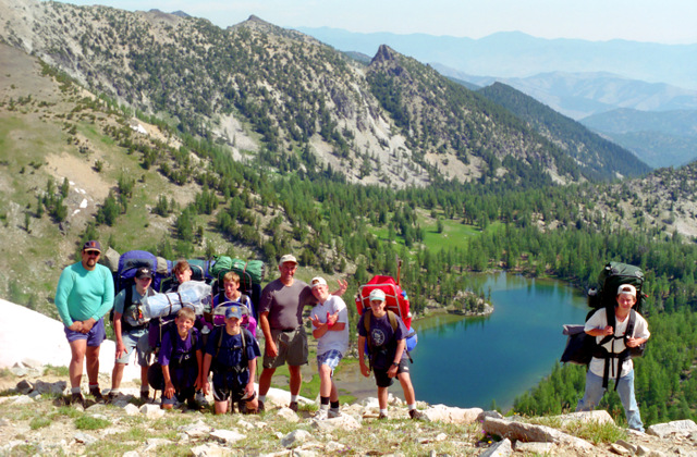
enlarge 416KB, 1024x674 8 97George002 Gang at Lower Martin Lake.
enlarge 490KB, 674x1024 9 97George003 Martin Peak and Lower Martin Lake.
enlarge 462KB, 1024x653 10 97George004 Shelby, Peter (behind tree), Danny, and Adam.
enlarge 417KB, 671x1024 11 97George005 On the trail between Martin and Cooney Lake. Adam, Peter, Danny, Chip, Brian, Bill P., Austin, Roger, and George.
enlarge 527KB, 1024x678 12 97George006 Bill Peckinpaugh bringing his gear into the campsite.
It was an easy day to get to Cooney Lake from Martin Lakes. All the good camps at the lake were taken so we made our camp in the meadows below the lake.
enlarge 456KB, 1024x674 13 97George007 Brian and Bill P. on the Angel Staircase above Lake Cooney. Additional stats for side trip up the Angel Staircase: 1.5 miles and 750' climbed
Not having hiked the Angel Staircase before, Bill P., Brian, and I headed up the trail to check it out. There was a large snowfield that we could see from the lake, and I was worried that the trail would not be open (it was still early in the year).
enlarge 301KB, 674x1024 14 97George008
Brian on the Angel Staircase Trail - Martin Peak in the background.
enlarge 365KB, 1024x762 15 97George009 Cropped version of previous photo.
enlarge 315KB, 1024x674 16 97George010 The signpost here marks the junction with the Sunrise Lake trail.
The first pass along the Angel Staircase - we found that the trail was open (the trail skirted the snowfield that had me worried).
enlarge 311KB, 1024x670 17 97George011
View of Sunrise Lake and Merchant's Basin from the pass above Cooney Lake (Elev 7950').
enlarge 420KB, 1024x671 19 97George013 On our way back down - Brian and Bill.
enlarge 363KB, 644x1024 20 Map Day 3 DAY 3
Online Caltopo Map for Day 3 is HERE
Day 3: From Cooney Lake to Junction Camp via the Angel Staircase
This was very pleasant hiking - very scenic vistas of the cascades from atop the Angel Staircase and the lush meadows and forests of the Chelan Summit. Camping at the "Junction Camp", gave us enough leisure time to try our hands at fishing in Boiling Lake (Bill P, Brian, Austin, Shelby, Peter, Danny, Chip, and Adam) or just to relax around the campfire and watch the sun go down (Bill M, Roger, George).
enlarge 188KB, 1024x769 21 Day 3 Stats for Day 3
Additional Stats for Day 3:
Day trip to Boiling Lake: +2.0 mi +419'
Waypoints (WP) correspond to those shown on the Caltopo Map. Stats include the Elevation; change in Elevation from the previous WP; Up/Down; Cumulative Elevation gain/loss; Distance in miles from previous WP; Cumulative Mileage for the Day; Cumulative Mileage for the Trip
enlarge 366KB, 1024x673 22 97George014 Day 3: Danny, Chip, and Peter in camp pumping water.
Peter got his nickname as "Bucketfoot" by putting his foot in the Pot we had cooked supper in. Fortunately, we had already doled out the portions.
As you can see, if you are going to hike the Chelan Summit in July there are going to be hordes of bugs!
Cascade Bill tip: If you are going to pump water, always pump from a water jug or pail and not directly from a stream or lake. Doing so allows sediment to settle and you can find a comfortable spot to sit while pumping. As a bonus, your filter will last much longer.
Heading up the Angel Staircase. You can see the snowfield that had me worried. From L to R: Austin (red pack), Roger, Shelby, and George.
enlarge 415KB, 1024x674 25 97George017
Shelby and George below with Brian and Bill P. above heading up the very steep Angel Staircase. You can see the trail as it goes past the snowfield.
enlarge 372KB, 1024x672 26 97George019 View of Cooney lake from this vantage point is very spectacular.
enlarge 351KB, 1024x674 27 97George020
Standing: George, Peter, Chip, Danny, Bill P., Adam, Austin, and Roger. Kneeling: Shelby, and Brian.
enlarge 382KB, 1024x674 28 97George021
If you look close you can see Brian's purple Jansport Pack. He took so much crap about it we never saw it on another trip.
enlarge 311KB, 1152x603 29 Angel Staircase E
Google Earth Ground Level view of the Angel Staircase trail (KML file exported from Caltopo map) as it climbs above Cooney Lake.
enlarge 374KB, 1024x674 30 97George022
You can see the guys going up the trail as it crosses the talus slope just below the ridge crest. When you get to the pass above Cooney Lake you groan as you see that you have another 150-200' to climb to reach the ridge above Merchant's Basin.
enlarge 360KB, 1024x671 31 97George023
Chip, Peter, Adam, and Danny at the crest. You can't see Lake Chelan from here but you can see the peaks on the western side of the lake. You can just make out Glacier Peak at the center as it is masked by a nearer peak on the west side of Lake Chelan.
enlarge 379KB, 1024x671 32 97George024
Once you reach the crest, the trail continues to traverse in a southerly direction before going over to the other side for the descent. Pyramid Mountain (on the west side of Lake Chelan) can be seen on the opposite ridge above and to the right of the last hiker.
enlarge 405KB, 1024x674 33 97George025 Another view.
enlarge 297KB, 1152x706 34 2003-401-35-40
Composite photo from a solo trip I made in September 2003 looking north from the crest of the ridge. Fall colors are dominant in this photo.
enlarge 267KB, 1152x603 35 Angel Staircase W
Google Earth Ground Level view from the vantage point of the previous photo. The route in red was generated from a KML file exported from the Caltopo map of the trip. If you enlarge the photo you can see Gray Peak far in the distance that we would reach 4 days later.
enlarge 365KB, 1024x672 36 97George026 Chip, Peter, Danny Adam, George, Roger, Austin, Shelby, Bill P., and Brian.
Its a steep descent on the western side of the Angel Staircase to the junction with the Chelan Summit Trail. This is typical of the stretch north of the trail junction as the trail traverses pleasant meadows with views in all directions. Star Peak is in the far distance.
Unfortunately, when I changed the film after this shot, it wasn't engaged and I got no pictures from here to the pass above Tuckaway Lake. I've added photos from other trips along this hike to fill in the missing gap in photos.
enlarge 297KB, 1024x678 37 1991-191-014 Boiling Lake (1991 photo)
I had made the mistake of camping at Boiling Lake on my first trip along the Chelan Summit Trail. Because of the clouds of mosquitos around the lake, camping at the junction of the Eagle Lakes Trail and the Summit Trail is much more pleasant.
enlarge 267KB, 680x1024 38 1989-166-010 Boiling Lake (1989 photo)
It's a little less than a mile and about a 300' climb from Junction Camp to Boiling Lake and some of us hiked up there to wet their lines in the lake. As Shelby was casting a group of horse riders went by, and a lady asked, "How is the fishing?". Shelby pulls a trout out of his pocket and says, "pretty good", and then pulls a frog out of his other pocket and says, "Frogs aren't bad either".
This is probably my favorite campsite. It has a table, a firepit, and a KYBO (pit toilet in boy scout jargin). As we were sitting around the campfire, someone found a huge green cricket like bug. Somebody said, "how much money would it take for you to eat that bug?". Shelby said he would for 20 bucks. So the rest of us ponied up the money Shelby ate that "cricket" like bug that was about 2 inches long, not just swallowing it, but crunching it with his teeth. When asked why he did that, he said that "If I'm going to eat it, I might as well see what it tastes like!
enlarge 355KB, 1024x668 40 2003-401-026 2003 photo looking west from Junction Camp
The Signpost shows the junction of the Cub Lake Trail with the Summit Trail. The sounds of the nearby creek soothe you to sleep and the trees provide welcome shade and the views as the sun sets are divine.
As we were sitting around the campfire, Bill Peckinpaugh looks at me and says, "You're that Guy!". Turns out, several years before, we had hired a local wood worker to refinish several tables and other items for us. I have our living room wall covered with photos of our hiking and backpacking adventures and the finisher was amazed and said he wished that he and his boys could do the same. After several backpacking trips and overnight outings with me since his boys had joined Troop 24, Bill P. recognized that I was indeed, "That Guy"!
enlarge 357KB, 1024x675 41 Map Day 4 DAY 4
Online Caltopo Map for Day 4 is HERE
From Junction Camp to the Upper Surprise Lake Camp
This was the longest hiking day of the trip in miles and a close second in elevation gain. After climbing to Chipmunk pass with good views the trail dips down into forested areas followed by a long climb back up to meadows near the top of the ridge above Surprise Lake. We camped at the Upper Camp so we wouldn't have to drag our packs up from the lake the next day. Most of us stayed in camp but Brian/Austin/Shelby did a day trip down to the lake.
enlarge 199KB, 1024x807 42 Day 4 Stats for Day 4
Additional Stats for Day 4:
Day trip to Surprise Lake: +1.6 mi +694'
Waypoints (WP) correspond to those shown on the Caltopo Map. Stats include the Elevation; change in Elevation from the previous WP; Up/Down; Cumulative Elevation gain/loss; Distance in miles from previous WP; Cumulative Mileage for the Day; Cumulative Mileage for the Trip/
enlarge 303KB, 1024x677 43 1989-166-021 1989 Photo View of Cub Lake far below as we approach Chipmunk Pass
View to the north from Chipmunk Pass. We would descend to the valley below and climb up the forested belt at the center of the photo and head to the left towards Surprise Lake.
enlarge 327KB, 1152x591 45 chipmunk pass
Google Earth Ground Level view from Chipmunk Pass (see previous photo). The routes in red and blue were generated from a KML file exported from the Caltopo map of the trip.
enlarge 292KB, 1024x689 46 2002-387-001
2002 photo of Danny Stallings & Kyle Meissner at the camp above Surprise Lake.
We camped here in 1997 and in 2002. I don't think we went down to Surprise Lake on this trip as we had had a long day. One memorable moment (well that may be stretching it, maybe unforgettable is more appropriate) of this camp is that we got to see a double full moon. As the moon was rising above our camp, George decided to bend over when he was taking a bath in the creek.
enlarge 415KB, 758x1024 47 Map Day 5 DAY 5
Online Caltopo Map for Day 5 is HERE
Upper Surprise Camp to Tuckaway Camp
This part of the route is why I love hiking the Chelan Summit - you stay high for most of the day and the views make your feet seem to step more lightly. Only one pass to climb so there isn't that much elevation gain and the Tuckaway camp is one of the best along the route. In the years since this trip, there was a forest fire so it is a little less pleasant than it was: as shown in THIS 2009 photo along the section before reaching Tuckaway Camp.
enlarge 178KB, 1152x700 48 Day 5 Stats for Day 5
Additional Stats for Day 5: Day trip to Tuckaway Lake: +1.1 mi +412'
Waypoints (WP) correspond to those shown on the Caltopo Map. Stats include the Elevation; change in Elevation from the previous WP; Up/Down; Cumulative Elevation gain/loss; Distance in miles from previous WP; Cumulative Mileage for the Day; Cumulative Mileage for the Trip
enlarge 268KB, 1024x683 49 1989-167-004
Surprise Lake Trail as it climbs to the ridge above the lake. View is to the west. A trail over the pass in the distance leads to Indianhead Basin. I camped there in 1989.
enlarge 225KB, 734x1024 50 1989-167-003
View of Surprise Lake from the Trail. The lake is good fishing for small brook trout - but it is a long way down if you camp at the lake.
enlarge 357KB, 1152x603 51 Ridge above Surprise Lake
Google Earth Ground Level view from the ridge above Surprise Lake (see previous photo). The routes in red was generated from a KML file exported from the Caltopo map of the trip showing the trail we had hiked the previous day.
enlarge 184KB, 1152x351 52 1989-167-009-10-11 Composite photo of View to the north from Pass 7420
enlarge 242KB, 1152x602 53 Pass 7420
Google Earth Ground Level view from Pass 7420 (see previous photo). The route in red was generated from a KML file exported from the Caltopo map of the trip showing the trail ahead of us.
This is one of the best camps along the Summit Trail. We camped here in 1997 and 2009. I can't remember if I camped here in 1989. It has a great view and an awesome firepit. The trail to Tuckaway Lake and the Oval Lakes starts here.
enlarge 358KB, 676x1024 55 1989-167-013 Tuckaway Lake - 1989 Photo
In 1982 my son Greg and I traveled along the Summit Trail. As we crossed the creek from Tuckaway Lake (you can step over it), we saw a small trout swimming in a pool, which was so strange for such a small stream. I filed in the back of my mind.
This photo is from my solo trip in 1989. When I scanned this image in I thought it was from Star Lake (Where Greg and I had camped in 1982) as I didn't remember going up to Tuckaway Lake that trip. Day 5 of the 1997 hike was fairly short with a moderate climb, we had a lot of time to hike up and do some fishing for small trout.
enlarge 374KB, 1024x671 56 1989-167-014 Basin Below Tuckaway Lake - 1989 Photo Hiking back down to the Tuckaway Basin camp from Tuckaway Lake.
enlarge 419KB, 1024x772 57 Map Day 6 DAY 6
Online Caltopo Map for Day 6 is HERE
From Tuckaway Basin Camp to West Oval Lake with a side trip up to Gray Peak.
A very short and fun day over an old trail to W Oval Lake. Fishing was very good and the views from the top of Gray Peak were spectacular.
enlarge 204KB, 1024x868 58 Day 6 Stats for Day 6
Waypoints (WP) correspond to those shown on the Caltopo Map. Stats include the Elevation; change in Elevation from the previous WP; Up/Down; Cumulative Elevation gain/loss; Distance in miles from previous WP; Cumulative Mileage for the Day; Cumulative Mileage for the Trip/
enlarge 359KB, 1024x670 59 97George027 Hey, the camera is working again.
Roger, Austin, and Chip taking a break at the pass above Tuckaway Lake.
Some of us headed up the ridge to climb Gray Peak. While we were away, Bill P. and George put a 15 pound rock in Adam's pack. (to be continued.)
enlarge 412KB, 1024x672 60 97George028
On the way to Gray Peak - we get this view of tiny Tuckaway lake, aptly named as it is truly tucked into a basin.
The previous day we had day hiked up to the lake to do some fishing for small trout.
enlarge 315KB, 1024x670 61 97George029 Another view from the ridge on the way to Gray Peak.
enlarge 246KB, 1024x671 62 97George030 Gray Peak is a "bump" along the ridge.
enlarge 240KB, 1024x671 63 97George031
If you enlarge the photo you can see the guys as stick figures along the ridge.
enlarge 230KB, 1024x671 64 97George032
Enlarge to original size to see the guys at the summit of Gray Peak (Elev 8082).
enlarge 257KB, 1024x669 65 97George033
Adam, Shelby, Austin, and Brian at the summit of Gray Peak.
enlarge 228KB, 1024x673 66 97George034
Looking SW from the summit - Pyramid Peak can be seen at the left side of the picture (peak with finger like snowfield extending to the ridge.
enlarge 373KB, 1024x670 67 97George035 The guys are heading back down the ridge.
enlarge 346KB, 1024x670 68 97George036
Looking north from the summit towards Tuckaway Lake. If you enlarge to original size, you can see the packs and the guys that didn't want to climb Gray Peak on the ridge just above where the trail down to the W Oval Lake heads down the slope.
enlarge 422KB, 1024x668 69 97George037
Looking east, we can see West Oval Lake, which is our day's destination.
enlarge 290KB, 1024x675 70 97George038
Looking south from the summit. If you enlarge the photo to original size, you can see the old sheepherder trail as it reaches the crest of the ridge below Gray Peak. My son Greg and I tried to find this trail in 1982, which was marked on the old Green Trails map, but we couldn't find it. In 2002, Danny Stallings, Kyle Meissner, and I came up it after Danny found the vague tread. The Chelan Summit Trail comes over the pass (7420) to the right of the peak above the snowfield at the center of the picture.
enlarge 385KB, 1024x672 71 97George039 Another view of Tuckaway Lake from Gray Peak.
enlarge 480KB, 1024x670 72 97George040
Packs on and heading down. We don't go on the trail that extends up to the top of the photo as that goes over the ridge to Middle Oval Lake. You can't see the junction with the Oval Lakes Trail from here.
By the way, I wonder if Adam is feeling the extra weight!
enlarge 290KB, 1024x670 73 97George041
On the way down, a snowfield covered the trail. Shelby took a spectualar spill along here, and Adam found a "lucky" horseshoe.
enlarge 307KB, 1024x674 74 97George042 On the way down.
enlarge 256KB, 1024x674 75 97George043 Chip and Danny - taking a dip in West Oval Lake.
When we got to the lake, we were all sitting around deciding where to set up camp, when Bill P. and George pulled big rocks of their packs (which they had just surreptitiously put in). George looked at Adam and said, "I can take a lot of things, but this is just BULLSHIT!. Adam said "It wasn't me, it wasn't me", and then found the big rock in his pack. We all got a big laugh.
enlarge 454KB, 1024x673 76 97George044
The fishing was good in the lake. We had a pool going for the biggest fish (about 25 bucks), and there were some big fish caught.
Adam (it just wasn't his day) got a really big one on. Bringing it in he picked up the line, and gave it a whack with his "Lucky" horseshoe. Instead of killing the fish, he knocked it back into the water.
enlarge 172.12MB, 1024x682 77 BillP-Luckyhorseshoe.mp4 VIDEO - Click Photo to View.
Bill Peckinpaugh tells the story of the "Lucky" horseshoe and the rocks in the pack. - Troop 24 Kickass Trekkers 2010 reunion.
enlarge 334KB, 675x1024 78 Map Day 7 DAY 7
Online Caltopo Map for Day 7 is HERE
Not much to say about Day 7's hike - "Time to Get Outta Dodge" is the main sentiment so long and boring. I remember playing "20 Questions" as we hiked out. The Pasayten Burger in Winthrop was as good as ever.
enlarge 186KB, 1024x747 79 Day 7 Stats for Day 7
Waypoints (WP) correspond to those shown on the Caltopo Map. Stats include the Elevation; change in Elevation from the previous WP; Up/Down; Cumulative Elevation gain/loss; Distance in miles from previous WP; Cumulative Mileage for the Day; Cumulative Mileage for the Trip/
enlarge 491KB, 1024x670 80 97George045 Day 7 - heading out from our camp at West Oval Lake.
When you leave camp and climb the minor ridge above the lake, It's just a relentless slog down the valley to the trailhead where our shuttle car is parked. The only thing you're thankful for is that you're not hiking up the trail.
enlarge 410KB, 1024x641 81 97George046
Cascade Bill, Austin, Shelby, Brian, Peter, Adam, Bill P., George, Danny, Chip, and Roger.
enlarge 486KB, 1024x671 82 97George047 Another view.
enlarge 402KB, 1024x673 83 97George048 The Peckinpaugh Clan:Bill, Brian "Buckwheat" Sisk, and Austin.
enlarge 383KB, 1024x671 84 97George049 The old Farts: Bill P., Bill M., George.
enlarge 383KB, 1024x672 85 97George050 The "kids": Austin, Shelby, and Roger.
enlarge 559KB, 1024x1008 87 Car Shuttle Online Caltopo Map for the Car Shuttle is HERE
This is one of the longest car shuttle trips you will find. Not only is it long (28 mi with 3900/5600 ft elev gain/loss, but it snakes up and down mountains and valleys over gravel Forest Service roads so your average speed is minimal.