Adults on this trip:
Cascade Bill Mooseker, Sam Spencer
Scouts on this trip:
Kyle Meissner, Cary Walker, Andrew Mooseker, Scott Ragan, Ben Spencer
Troop 24’s monthly outing for June 1996 was split into two overnight hikes. One group hiked up Thunder Creek and the other hiked up the west side of Ross Lake to Big Beaver Camp. This album describes the Ross Lake/Big Beaver hike.
Because the snowpack at the higher elevations hadn’t melted it was necessary to do a low elevation hike and the west bank of Ross Lake Trail certainly fills the bill. The one way distance for the hike is 7.25 miles, making a 14.5 mile round trip. Unfortunately, the high point of the trip is at the start, which makes the return trip much harder. For the trip in to Big Beaver Camp there is an elevation gain of 800 ft and a loss of 1330 ft (which has to be regained on the return trip) giving a net 2130 ft of total elevation gain for the hike.
I hadn’t taken very many photos in 1996 so I’ve supplemented them with a few images from 2005 when I repeated this hike with my college friend, Peter Sexton. These have been noted in the album.
Big Beaver Camp is a boat camp but we were able to use it as the water level in the lake was too low for boats to land at the camp.
The descriptions under the photo thumbnails in the album sometimes contain links to maps or additional information. These are identified by "Blue” text for links.
Note: I have added a map (JPG files suitable for printing) for the hike from the CalTopo map which can be found HERE. CalTopo gives the option of viewing the map using several different base layers (I have used the Caltopo "Topo" layer for this album as the Forest Service map does not cover some areas of the National Park and Ross Lake Recreation Area). Use the right sidebar "Layer" to choose the displayed layer: Topo (T), Hybrid (H), Imagery (I), Scanned Topos (U), and Forest Service. (values in parentheses are keyboard shortcuts).
Maps are best viewed at "Original" size. To view at "Original" size, click on Thumbnail to enlarge the map, then click again to access the original resolution. Move the cursor to the point on the map that you want to enlarge and then click the cursor to zoom in or out.
Troop 24 "The High Adventure Troop"
-Cascade Bill Mooseker
Date(s): June 1996. Album by Cascade Bill. 1 - 22 of 22 Total. 87 Visits.
enlarge 349KB, 759x1024 1 1996 Ross Dam to Big Beaver Camp Online Caltopo Map can be accessed HERE
enlarge 356KB, 713x1024 2 RossLk05-02 Pete Sexton and Ross Dam from trail (From my 2005 hike with Pete Sexton)
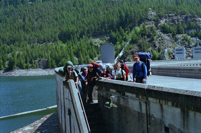
The hike begins at a parking lot off of Highway 20 and descends through forest on a combination of trail and access roads until the west end of Ross Dam is reached. From there you hike across the top of the dam to reach the main trail that goes up the west bank of Ross Lake.
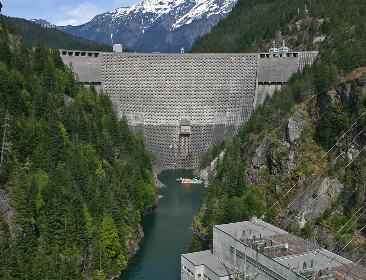
enlarge 235KB, 713x1024 3 RossLk05-03 View of Powerhouse below Ross Dam from the trail (From my 2005 hike with Pete Sexton)
enlarge 333KB, 768x1024 4 diablod-033b View of Powerhouse and Ross Dam from Diablo Lake Boat Tour (2008)
enlarge 228KB, 679x1024 5 96-269-010 Spillway of Ross Dam and upper end of Diablo Lake
enlarge 298KB, 1024x674 6 96-269-011
Guys looking over the downstream edge of Ross Dam and the east spillway below - It's a long way down. A view of the downstream side of the dam can be found HERE, which can be used to locate the spot where the photos were taken.
enlarge 292KB, 1024x676 7 96-269-012
Ben Spencer, Scott Ragan, Sam Spencer, Kyle Meissner, Cary Walker, Andrew Mooseker
enlarge 318KB, 1024x676 8 96-269-013 Cary, Ben, Andrew, Kyle, Scott, and Sam
The dam (after all I'm a structural Engineer) is designed as an arch which curves into the water transferring the forces generated by the water pressure to the bedrock on either side of the dam.
enlarge 286KB, 713x1024 9 RossLk05-04 Peekaboo View of Ruby Mountain (From my 2005 hike with Pete Sexton)
enlarge 326KB, 750x1024 10 RossLk05-05 Looking up Ross Lake from trail (From my 2005 hike with Pete Sexton)
enlarge 288KB, 1024x675 11 96-269-014 Scott, Andrew, Cary, Kyle, and Ben
The trail after crossing Ross Dam is miles and miles of forest hiking, which though pleasant, is not really scenic with limited views of Ross Lake. We took a break at this bridge over Pierce Creek near the end of our hike.
enlarge 393KB, 713x1024 12 RossLk05-13 Suspension Bridge over Big Beaver Creek (From my 2005 hike with Pete Sexton)
enlarge 362KB, 1024x732 13 RossLk05-14 Big Beaver Creek from Suspension Bridge (From my 2005 hike with Pete Sexton)
enlarge 261KB, 1024x679 14 96-269-015 Jack Mtn across the Lake from the trail to Big Beaver Camp
After you cross Big Beaver Creek on a bridge you join the Big Beaver Trail. If you go left you follow Big Beaver Cr up to Beaver Pass in North Cascades NP. But we go right as we're in shouting distance of our destination at Big Beaver Boat Camp.
enlarge 220KB, 681x1024 15 96-269-016 Looking back up Big Beaver Creek to 6607' Niaka-Pamux Peak (on the left)
Because this was in early June the water level in the lake is much lower because the snowmelt is continuing. Later in the summer this area will be flooded as the dam reaches its capacity.
enlarge 249KB, 1024x677 16 96-269-017
Looking up Pierce Creek to the long ridge of snow covered Sourdough Mountain. All the stumps you see will be underwater later in the summer
Packed up and ready to leave our camp at Big Beaver Camp. Sam Spencer had left earlier with Ben and Scott but we decided to linger a while longer at the lake. Being new scouts Ben and Scott were introduced to "Snipe" hunting the previous night by the older scouts.
enlarge 274KB, 1024x677 18 96-269-019 Cary and Kyle
Note the Bear Box at the left where you can safely put your food to keep it away from all pesky wildlife up to and including bears.
enlarge 241KB, 678x1024 19 96-269-020 On our way out, Andrew, Cary and Kyle
enlarge 260KB, 675x1024 20 96-269-021 Kyle, Andrew, and Cary
It was a long hike back to the cars. I remember that when we got back to the dam, somebody said that since we'd been out of touch a nuclear bomb could have gone off and we wouldn't know it. Kyle as usual (see 1996 Olympic NP Beach hike) wanted a quantitative measurement: "Could you hear it if it went off in Seattle? How about Spokane? Etc?
enlarge 290KB, 1024x677 21 96-269-022
Heading back we took another break at the Pierce Creek bridge. I like the use of the rock pier in the center. Seems to me that the rectangular notches in the side logs were used in times past for rail posts. The rock abutment wall and the bridge are possibly the work of a CCC crew in the 1930's.
enlarge 297KB, 1024x713 22 RossLk05-06 Cascade Bill (From my 2005 hike with Pete Sexton)
Apparently the old bridge over Pierce Creek succumbed to either rot or flooding and this new one had been built in the intervening 9 years since I had been there with the scouts in 1996
