Olympic NP: Rialto Beach to Lake Ozette
April 11-14, 1996
by Cascade Bill Mooseker
Red Hot Chilean Rockpounders Rounding Cape Johnson
Sandpoint Beach Bums (Sand Point to Rialto Beach)
Adults in this group:
Greg "Packhorse" Phillips
Cliff "I'll Be On the Next Ferry" Mayes
Scouts in this group:
Jason "I Want To Be Home By 4 O'clock" Smith
Adam "Whattdoya Mean It's One More Mile" Phillips
Thomas "Where's My Oatmeal" Mayes
Shelby "Raccoon Doom" Stong
Eric "It Must Be a Jansport, Cuz Your Sleeping Bag Hits Your Butt On Every Step" Walkingshaw
Red Hot Chilean Rockpounders:
Adults in this group:
Bill "Foilman" Mooseker
Greg "Can't Light a Fire In a Hailstorm" Mooseker
Steve "Who Talked Me Into This" Goodwin
Scouts in this group:
Cary "Shoreline" Walker
Peter "I Hate This Pack" Goodwin
Kyle "Sandman" Meissner
Andrew "Dirtyface" Mooseker
For spring vacation, we had originally planned to hike the Chelan Lakeshore Trail but the dock at Prince Creek was under repair, so we had to find an alternate trip. In April, the mountain trails are covered with snow and about the only alternative is the ocean even though we had done the Cape Alava - Sand Point loop the previous year.
This year our trip was to be much more ambitious- the rugged 20 mile hike from Rialto Beach to Lake Ozette. In order to do a one way trip we had to split into two groups. These shall hereinafter be known as the "Sand Point Beach Bums", who went south from Lake Ozette to Rialto Beach, and the "Red Hot Chilean Rockpounders", who went north from Rialto Beach to Lake Ozette.
There is something elemental about hiking along the coast. The weather is constantly changing and as you hike along, the tides are always in a state of flux. The terrain is never the same. Ideally, you go over hard packed sand but more likely it is soft and sticky, sapping energy and speed. Then there is small pebbles, mid size pebble, larger ones that can roll your ankle. Always there is the roar of the waves rolling in and the wind whistling by (hopefully at your back). Then stretches of scrambling over rocks, driftwood jams, and steep headlands that you have to clamber over. If you want to get a feel for this hike, this unnarrated YOUTUBE VIDEO the describes the first couple of days of our trip is worth watching.
Note: References to "Petroleum Creek" in this album are incorrect. Petroleum Creek is located much further north on Shi Shi Beach. I was going on what we were told on the trip by a group of day hikers we met. The creek we mistakenly called, "Petroleum" Creek is actually an unnamed creek a little ways south of the Norwegian Memorial.
The descriptions under the photo thumbnails in the album sometimes contain links to maps or additional information. These are identified by "Blue” text for links.
Depending on your screen resolution, the photo thumbnails may appear fairly small. You can enlarge the thumbnails by holding down the "Ctrl" key (bottom left of the keyboard) and then use the mouse wheel up or down to optimize the thumbnail size.
Note: I have added maps (JPG images suitable for printing) for each day of the hike from an online map that I created for the hike using Caltopo mapping software. This Caltopo map can be found HERE. While viewing the online map you can switch the view by hitting the "T" key for the "Mapbuilder Topo" layer; the "U" key for the "Scanned Topos" layer; and, the "I" key for the "Sattelite Imagery" layer. The Default layer is the "Scanned Topos" layer (I think it is a little cleaner than the "Mapbuilder" layer). Switching to the "Satellite Imagery" layer can be illuminating as it shows the actual terrain.
Map images shown in the album are best viewed at "Original" size. To view at "Original" size, click on the map thumbnail to enlarge the map (usually in a new tab). While holding down the "Ctrl" key click on the enlarged image to access the original resolution. Move the cursor to an area on the map that you want to enlarge and then click the cursor to zoom in or then click again to zoom out.
Troop 24 "The High Adventure Troop"
-Cascade Bill Mooseker
Date(s): April 11-14, 1996. Album by Cascade Bill. 1 - 21 of 21 Total. 105 Visits.
enlarge 354KB, 1024x702 1 pics 1
To enlarge photos, click on the thumbnail - the photo will pop up enlarged to 1024 pixels max (height or width). To view at Original size (best for maps, etc.), Ctrl-Click on the Photo, and finally a 3rd click to enlarge to the original resolution. Click again to reduce back to fit the screen again.
If you want to save photos to your computer, click the box under the thumbnails of all the photos you want to download (or check the "select all" box at the bottom of the album). Then click the "Download" button at the top of the album. Pick the size you'd like to download (Original is best)and the photos will be downloaded as a zip file to the folder of your choice.
enlarge 194KB, 791x1024 2 Washington State Ferries - Route map1
The R.H.C. Rockpounders got to Rialto Beach late due to a ferry mix-up. While we took the correct ferry (Edmonds) the Sandpoint Beachbums incorrectly took the Mukilteo ferry(????) and ended up on Whidbey Island rather than the Olympic Peninsula. When the other group didn't show up we were really perplexed and it took a long time and many phone calls to get it straightened out. The Beachbums had to take the Coupeville Ferry to Port Townsend ferry to get to the peninsula. After a couple of hours we finally met up. Since one group was going south and the other group north, we switched cars so each group would have their own cars to drive home.
When we go to the trailhead the wind was blowing hard and the rain was coming down in buckets. We had a cozy lunch in the rest room - out of the wind and rain. Hoping that it would let up we would peek out every 5 minutes or so, but it kept pouring. After a long wait we suited up in our rain gear because it looked like the rain was never going to let up so we hit the beach despite the weather.
enlarge 284KB, 686x1024 4 1996 Pac Beach Day 1 Day 1: Rialto Beach to Camp 1 (3.8 mi) Caltopo Map for Day 1 is HERE
Fortunately, after being pelted for about 15 minutes the rain stopped and the sun came out soon after. It was easy going on the hard sand of Rialto Beach and we soon came to our first obstacle: Ellen Creek. Later in the summer this is just a trickle but it was swollen with the rain now. Greg made a run for it but all he got for his efforts was wet feet. The rest of us backtracked along the creek and found a relatively easy crossing over some handy logs. This Video shows how big an obstacle Ellen Creek can become.
enlarge 320KB, 699x1024 5 1969s-01-003 My dad, Hank Mooseker, at The Hole in The Wall
Because of the rain I had the camera in the pack so didn't get any photos on our first day. This photo was taken in 1969. At that time my dad was 50. In 1996, I was 3 years older at 53.
On our way again we soon made it to the "Hole in the Wall" which is a jutting "head" of rock which juts out blocking travel along the beach. The wind and waves have eroded a tunnel through the rock, which can be used at low tide to get to the other side where beach ends and rocks begin. You have to be careful here as it becomes impassible as the tides come in.
enlarge 261KB, 1024x699 6 1969s-01-004 Bill Mooseker - North Side of The Hole in the Wall 1969
After rounding several more heads, we came to the last one before the cove that contains the Chilean Memorial where we hoped to camp. The tide was coming in strongly as we rounded this head. On the north side, we saw 8 eagles soaring in the updrafts- an awesome sight. There was a nice camp at the tip of the head on the north side, but there was no water close by so we pushed on. Some of the boys saw a dead seal in the rocks here.
The tide had already covered the beach, so we had to clamber over rocks for the last half mile. Greg and Andrew were both caught by water splashing up from big waves. Near the memorial we found a couple of hardscrabble camps. The tents were soon pitched as well a tarp shelter for cooking. Odds and ends of driftwood etc. were collected and a serviceable cooking area with benches and a table constructed. Dinner was soon cooking - Beef Stroganoff, Hot cocoa, and Pudding.
enlarge 568KB, 768x1024 7 Chilean Memorial Chilean Memorial Photo -from Trillium's WTA report 8/6/2023
After dinner Greg decided he would build a fire. Looking for firewood, he found one side of the lower jaw of a bear. The front tooth was awesome looking like it could punch a hole through your skull. Just as he lit the first match the rain started up again. The more success he had, the harder it rained. The rest of us, huddled under the dining tarp, thought it was almost as amusing as Bill hanging the food. When it looked like it was finally going to get going, it started to hail - and that was the end of the fire. The kindling and twigs were dancing around as if they were targets of a machine gun. Greg muttered that the "Fire Gods" must not want him to start a fire and he beat a hasty retreat under the tarp with the rest of us.
enlarge 275KB, 674x1024 8 1996 Pac Beach Day 2 Day 2: Lot of Rockpounding but Scenic (5.5 mi) Caltopo Map for Day 2 is HERE
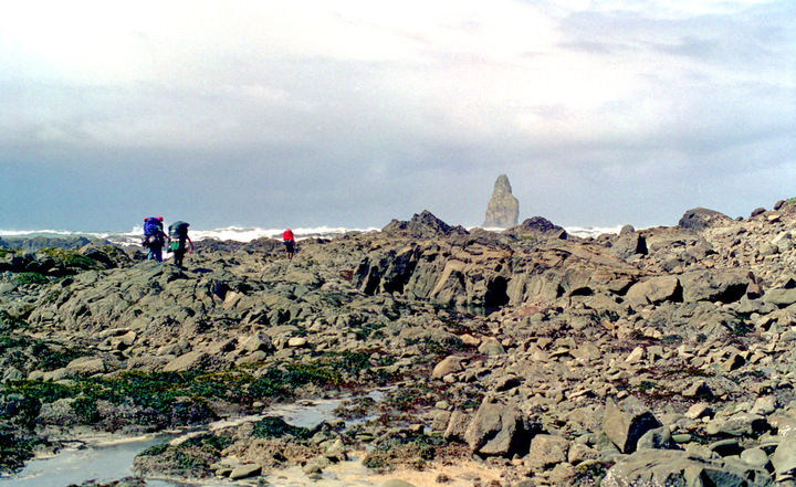
enlarge 488KB, 1152x706 9 96-268-011 Rounding Cape Johnson - Andrew, Kyle, & Steve
It rained hard all night along with strong winds that shook the tents. We didn't have to rush in the morning, because we had to wait for an outgoing tide to make it around Johnson Head. We packed up leisurely and were entertained by the sight of two eagles being chased by several seagulls.
After packing up, we headed out around Johnson Head. After rounding a couple more of the same, the rocks gave way to a hard packed curving beach. We met a couple with a boy who said that they were camped at "Petroleum" Creek, just south of the Norwegian Memorial where we had planned to camp that night. They told us that there was no water at the memorial so we forged ahead not knowing where we would end up.
enlarge 155KB, 1024x692 10 1969s-01-007 Bill Approaching Head That Needs to be Climbed - 1969
At the end of that beach, was a head that couldn't be rounded but had to be climbed over on a short trail. The boys had made some bets as to who would be the first person in our group would make it to the base of the head.
enlarge 323KB, 672x1024 11 96-268-015
The race was on! Cary was out in front about a 100 yards ahead of Bill, who was bringing up the rear as usual. The beach was curved in a long crescent. The tide had gone out a long way so Bill made a beeline for the trail by skirting close to the water's edge. Cary, however, kept a constant distance from the shoreline following a long curving traverse along the crescent. He was surprised near the end when he looked up and found that Bill was ahead of him. This was how he got his nickname: "Shoreline" Cary.
enlarge 225KB, 695x1024 12 1969s-01-011 Hank Mooseker Climbing the Head in the previous photos - 1969
On the other side of the head, were more sand beaches that made easy going. We passed several camps, and saw an old coast watcher's hut from World War II perched atop a cliff. It would have been nice to explore but it was a stiff climb and we had to make time while we could. As we made our way north the tide was coming in fast. We got wet feet a couple of times crossing some streams.
There is a shelter at Cedar Creek that would have made a nice camp. Some of the group wanted to stay there but we had one more head to get around to get on the same beach as the Norwegian Memorial. There were several very tame deer at the shelter when we passed. As we rounded the last head we could tell that the tide was almost in. We soon made our way to "Petroleum" Creek.
enlarge 366KB, 1024x671 14 96-268-013 Kyle, Greg, Cary, and Andrew at "Petroleum" Cr Camp (note color of water in the jugs) Andrew cooking dinner - Mountain Chili and Cheesecake.
Back in the woods south of the creek there appeared to be some packs, which we thought belonged to the couple we had seen earlier. We sat down on a log to figure out what we should do. There was another camp on the north side of the creek but it was full. It looked like we would have to push on ahead to the Norwegian Memorial after all and take our chances on the water. We sent Kyle back to check if there were any other sites back in the woods near where we had seen the packs. He yelled that what we thought were packs were just a pile of old floats someone had dragged up from the beach. That was enough for us- and we quickly had staked our claim to the site. There was even enough room for the southbound group if they made it this far.
enlarge 149KB, 398x1024 16 1996 Pac Beach Day 3 Day 3: The longest and hardest day (7.1 mi) Caltopo Map for Day 3 is HERE
We were a little leary of the racoons because the southbound party had had their food raided at Sand Point the night before. Fortunately when we woke, our food bag appeared undisturbed except for a few holes which we thought some crows had made earlier in the morning.
We gave the S.P. Beachbums some of our oatmeal and soups to make up for what had been eaten by the raccoons. After the food had been redistributed, Thomas came over looking for his private stash of oatmeal Bill told him it was now "group" oatmeal - that way everybody had the same amount. As Rockpounders hit the trail in the late morning, the Beach Bums were still packing up. We said our goodbyes and made plans to meet at Fat Smitty's near the turn off for Port Townsend at about 5:00 the next day (Sunday).
enlarge 268KB, 1024x686 17 96-268-014 Taking a break - Steve, Greg, Kyle, & Andrew
As we made our way up the beach, the winds were blowing hard from the south and the boys had fun kicking a cylindrelical float up the beach - it would roll and roll. We all decided we were glad we were going north and not south against the wind.
Near the Norwegian Memorial , we spotted an otter that ran into the water and swam parallel to the beach. Steve thought that it was a river otter that had carved a niche here on the ocean beach. Bill wondered if it was a sea otter because of its white whiskers.
I quess the otter knew what he was anyway. We soon hit the rocks and began a seemingly endless day of rockpounding. Kyle kept Greg "entertained" by asking him questions like: "Could 7 seagulls and 5 crows take 4 eagles? or Could 14 seagulls take 5 eagles, etc.. Fortunately Greg kept his sanity and sense of humor. Ummm, could 7 seagulls and 5 crows really take 4 eagles??? I wonder.
enlarge 290KB, 1024x653 18 96-268-016 Taking a Break - Kyle, Peter, & Andrew
As we rounded the umpteenth head, we were met with the welcome sight of Yellow Banks - a curving set of cliffs with a wide sandy beach. Our feet were very relieved and grateful for the hard sand which ended all too soon at the head north of Yellow Banks. The tide was visibly coming in now and we had to do a little scrambling up the rocks to round the head. There were some very deep tidepools worn into the rocks there that would have been fun to explore but it was getting late and we needed to get into camp. Doing dishes by flashlight gets old after a while.
enlarge 240KB, 791x1024 19 Yellow Banks to Camp 3 Click Thumbnail for easier reading
enlarge 270KB, 759x1024 20 1996 Pac Beach Day 4 Day 4: Boring walk to Trails End (4 mi) Caltopo Map for Day 4 is HERE
enlarge 276KB, 791x1024 21 Day 4 Trails end Click Thumbnail for easier reading