1983 Halfway Around Glacier Peak
Carne Mtn/Leroy Cr High Route
Spider Meadow - Lyman Lake
Cloudy Pass/ Image Lake
Dolly Vista/ Whitechuck TH
August 1983
Greg Emens & Pat Haller - Near the top of Spider Gap
Troop 24 Scouts: Greg Mooseker, Pat Haller, Randy Miller, Corby Miller, Greg Emens, Mike Ruhsenberger, Mike Baker
Troop 24 Adults: Bill Mooseker, Merl Weatherhogge, Bob Miller
Troop 24 "The High Adventure Troop" Backpacking Trip
-Cascade Bill Mooseker
Date(s): August 1983. Album by Cascade Bill. 1 - 104 of 104 Total. 860 Visits.
If you want to save photos to your computer, click the box under the thumbnails of the photos you want to download. Then click the "Download" button at the top of the album. Pick the size you'd like to download (Original is best)and the photos will be downloaded to a folder of your choice.
enlarge 467KB, 662x1024 2 t24-83 day 1-2
Map showing route for Days 1 & 2. - View Map at Original size for best view - red circles with numbers show locations of certain photos in album. (Note I've misplaced a tiny red 3 on the map- ignore
enlarge 102KB, 1152x669 3 day 1 Statistics for Day 1 along the trail - 3.2 miles and 2784' climbed.
This is from a BASIC program I wrote using a database compiled from using a "roller" measurement device along a route on a topo map. I still use the same program, but now I get the database from coordinates obtained from topo maps on CD's (Maptech).
enlarge 329KB, 674x1024 4 97kickass001 This photo is from Troop 24's 1997 trip.
The Carne Mtn Trail relentlessly climbs up out of the Phelps Creek Valley. Fortunately, most of the climb is in the shade of the forest, but near the top the trail enters meadows with expansive views.
enlarge 422KB, 1024x671 5 97kickass002 This photo is from Troop 24's 1997 trip.
Our first nights camp was in Carne Mtn. Basin, below Carne Mountain. This photo shows our camp from the ridge above the camp. It was only 3.2 miles from the trailhead to our camp, but we had to climb almost 2800 feet.
enlarge 417KB, 1024x674 6 97kickass007 This photo is from Troop 24's 1997 trip, but we camped in the same spot in 1983.
Our Camp in Carne Mtn. Basin - My first trip here was in 1969 - Sue and I, with her carrying Greg (2 years old) were very tired when we got to the basin and looking forward to making camp. Unfortunately, we found that the basin was occupied by about a thousand sheep and two Basque sheepherders.
enlarge 250KB, 1024x999 7 day 2 1 Stats for Day 2:
This is one of the hardest days, packs are still very heavy and much of the route is off trail. One of my favorite routes. I've done it 6 times now - 1969, 1980, 1983, 1986, 1994, and 1997.
enlarge 405KB, 1024x669 8 83-001-121-000 Looking east from the summit of Carne Mtn to Entiat Ridge.
enlarge 351KB, 1024x670 9 83-002-121-001 Looking up Phelps Cr towards Spider Meadow from the summit of Carne Mtn.
enlarge 354KB, 1024x672 10 83-003-120-008
Another view - you can see the Spider Glacier (the long thin ribbon of white to the left of Spider Meadow)
enlarge 336KB, 1024x668 11 83-004-121-002
Looking towards Phelps Ridge with Buck Cr Pass way in the distance from the summit of Carne Mtn.
enlarge 297KB, 1024x669 12 83-005-121-003
Looking across the Chiwawa Valley to Buck Mtn with a peekaboo view of Glacier Peak just to it's right.
enlarge 267KB, 1024x670 13 83-006-121-004
Looking SW from the summit of Carne Mtn.
enlarge 303KB, 1024x671 14 83-007-121-005 Cascade Bill at the summit of Carne Mtn.
enlarge 298KB, 674x1024 15 83-008-120-009 Greg Mooseker with Buck Mtn and Glacier Peak in the background.
enlarge 295KB, 1024x668 16 83-009-121-006
Descending Carne Mtn - the guys can be clearly seen if you enlarge the photo.
enlarge 294KB, 1024x665 17 83-010-121-007 Another view.
enlarge 296KB, 1024x666 18 83-011-121-008
enlarge 324KB, 1024x669 19 83-012-121-009 Looking back towards Buck Mtn.
enlarge 365KB, 674x1024 20 83-013-121-010
This shows how far we have climbed up from the valley below (Phelps Cr). Buck Mtn across the valley.
enlarge 376KB, 1024x671 21 83-014-120-010 Location 1 on Map D1
Taking a break on the Carne Mtn - Leroy Cr High Route - Mike Ruhsenberger (seated), Corby Miller, Pat Haller, and Randy Miller.
enlarge 380KB, 1024x673 22 83-015-120-011 Location 2 on Map D1
Heading up to the Pass above Chipmunk Creek - No trail here, you just try to find the best way up. Bob Miller and Merl Weatherhogge (and myself) bringing up the rear.
Click Here for a view of Troop 24 climbing the same hill in 1997.
enlarge 381KB, 673x1024 23 83-016-120-012
Looking back towards Box Cr. basin from near the pass to Chipmunk Creek.
enlarge 340KB, 672x1024 24 83-017-120-013
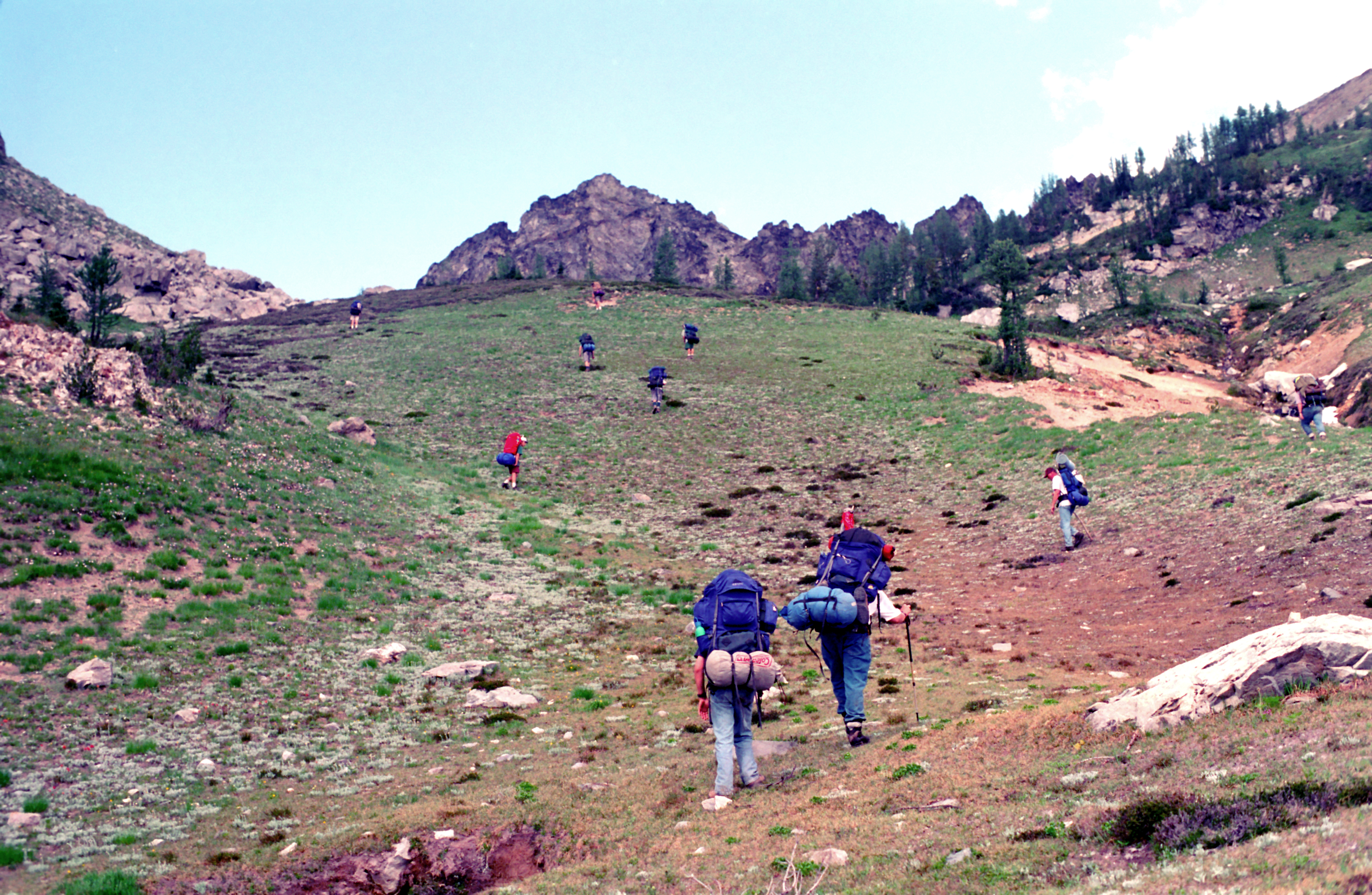
Chipmunk Cr Basin - there is some old tread down from the pass to this point, but it soon disappears in the meadows beyond.
enlarge 348KB, 1024x678 25 83-019-120-014
Greg - looking towards Spider Gap from meadows just past Chipmunk Cr basin.
From here on, the route gets much rougher as you have to drop down into a rocky basin around the corner. Traverse around the shoulder till you come to a talus slope, which you can work around on the left.
enlarge 307KB, 1024x669 26 83-020-121-011 Location 3 on Map D1
Group picture from ridge before descending into Leroy Cr basin.
As I noted a couple of photos ago, the route from Chipmunk Creek to Leroy Creek Basin is really rough, especially dropping down into the talus on the slopes of Seven Fingered Jack, which we are about to do here.
enlarge 216KB, 1024x672 27 83-021-121-012
(L to R): Merl Weatherhogge, Corby Miller, Greg Emens, Mike Ruhsenberger, Pat Haller, Randy Miller, Mike Baker, Bob Miller, Bill Mooseker
enlarge 431KB, 678x1024 28 83-022-120-015 Leroy Cr. Basin - Camp 2: Mtn in background is Seven Fingered Jack.
It was getting dark as we staggered into camp the previous night - Although the hiking was very scenic, it was also very taxing and quite a few of us went to bed as soon as the tents were pitched without having supper.
enlarge 481KB, 1024x662 29 t24-83 day 3 Map for Day 3: Leroy Cr Basin to Spider Meadow. Best viewed at Original Size.
enlarge 111KB, 1152x573 30 day 3 Stats for Day 3:
If it wouldn't be for the ankle killing steep descent for the ever worsening Leroy Creek trail, this would be a very easy day. After a relatively short day, you get to spend a relaxing time at one of my favorite camps: Spider Meadow.
enlarge 470KB, 662x1024 31 t24-83 day 4 Map for Day 4: Spider Meadow to Lyman Lake. (Best viewed at Original size.
enlarge 182KB, 1024x781 32 day 4 Stats for Day 4:
All I can say is it seemed much easier in 1980 and 1983 than in 2012 when I was 69!
enlarge 413KB, 1024x670 33 83-023-120-016 Group at Spider Meadow (Camp 3)- Beginning our hike up and over Spider Gap to Lyman Lake.
Bob Miller, Merl Weatherhogge, Mike Baker, Greg Emens, Corby Miller, Greg Mooseker, Mike Ruhsenberger, Pat Haller, Randy Miller.
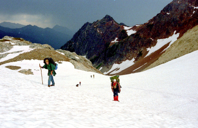
enlarge 289KB, 1024x669 34 83-024-121-013 Rain is moving in as we climb the Spider Glacier.
enlarge 327KB, 1024x665 35 83-025-121-014 Greg Emens and Pat Haller near the top of Spider Gap.
enlarge 301KB, 1024x670 36 83-026-121-015
Randy Miller, Bill M. and Bob Miller (way down the hill), Corby Miller, Merl Weatherhogge, and Mike Baker
enlarge 397KB, 1024x673 43 83-035-120-017 View from Spider Gap looking north.
Cloudy Mtn is obscured by clouds at the right of the picture. The incoming front can be seen at the left as the clouds are spilling over the Cascade Crest from the west.
enlarge 310KB, 665x1024 45 83-038-120-020 Mike Ruhsenberger & Merl Weatherhogge
enlarge 345KB, 1024x670 46 83-039-120-021 Looking back towards Spider Gap.
enlarge 224KB, 676x1024 47 83-040-120-022 Greg M. above the Lyman Glacier.
enlarge 285KB, 674x1024 48 83-041-120-023 Snout of the Lyman Glacier.
enlarge 328KB, 674x1024 49 83-042-120-024
Greg M. - you can see the moraine (dirty rock on top of the glacier) signifying that it is still active.
enlarge 365KB, 673x1024 50 83-043-121-023 view of the moraine building at the snout.
enlarge 372KB, 1024x669 51 83-044-121-024 Another view.
enlarge 427KB, 1024x661 52 83-045-121-025
The previous photos do not show the scale of the glacier - the blue speck left of center is Greg (enlarge photo), which shows exactly how massive the snout is.
enlarge 378KB, 671x1024 53 83-046-121-026
Another view. You can see that those crevasses could swallow a person very easily.
enlarge 295KB, 1024x676 54 83-048-120-025 Bill M - Lyman glacier in the background.
Bonanza Peak from the ridge above Lyman Lake. From here on there is a trail down to the lake.
enlarge 446KB, 1024x662 57 t24-83 day 5 Map for Day 5: Lyman Lake to Glacier Peak Mines. Best viewed at Original Size.
enlarge 187KB, 1024x805 58 day 5 Stats for Day 5: Not a hard day either in miles or climb. Scenery wasn't bad either.
enlarge 443KB, 673x1024 59 83-051-120-028
Our Camp (Camp 4) at Lyman Lake. Notice the old style single wall tents (from Sears). We did a service project for the Forest Service here as they were moving a Kybo and needed a new hole dug.
enlarge 291KB, 670x1024 60 83-052-120-029 View of Lyman Lake from near our camp.
enlarge 350KB, 1024x673 61 83-053-120-030
Another view - You can see that the rainy weather is gone here, but the wispy clouds forming over the ridge show that the west side of the crest was still cloudy due to an onshore flow.
enlarge 291KB, 1024x674 62 83-054-120-031
View from the west side of the lake, looking down Railroad Cr. - Bonanza Peak is to the left.
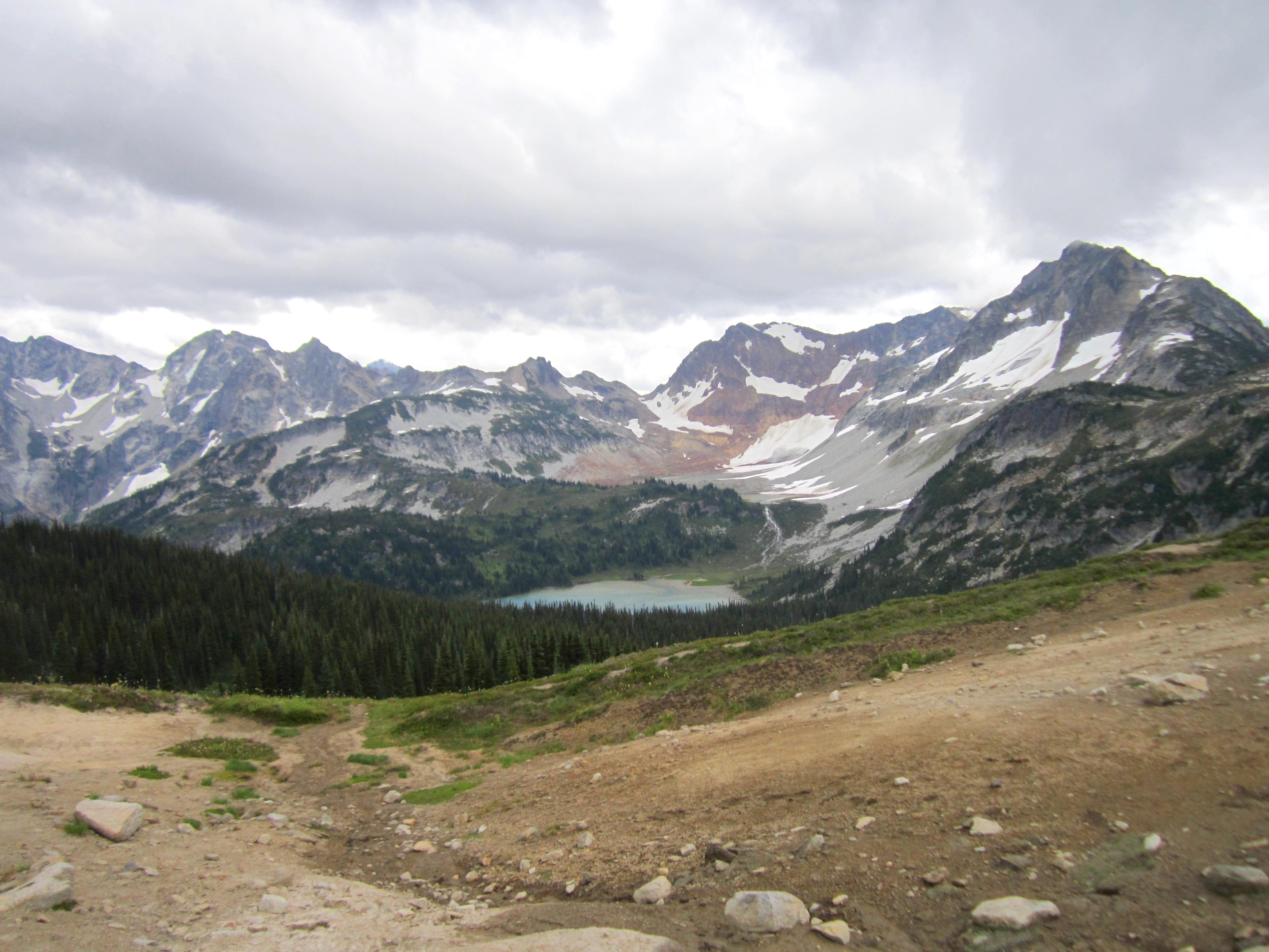
enlarge 324KB, 1024x670 63 83-055-120-032
View from Cloudy Pass, showing Lyman Lake and Glacier, as well as a good view of our route down from Spider Gap.
enlarge 296KB, 671x1024 64 83-056-120-033 Another view.
enlarge 296KB, 1024x673 65 83-057-120-034
Another view: Click Here to see how much the Lyman glacier has receded in 29 years in this photo from the same spot in 2012.
enlarge 312KB, 1024x671 66 83-058-121-028
The view from Cloudy Pass is considered as on the the best in the Cascades. Another of the best is the view from Image Lake towards Glacier Peak. It's sad that the the Crest Trail was relocated to a very unscenic valley pound from the Suiattle River to Suiattle Pass and most through hikers miss both of those views.
enlarge 282KB, 676x1024 67 83-059-120-035 Telephoto view. (Yes I used to lug a telephoto lens along).
enlarge 334KB, 1024x678 68 83-060-120-036
Another telephoto view. If you compare the extent of the snowfields in 1983 vs 2012 you can see the it was a lot easier to negotiate the route in 1983 than 2012 as there was much more snow glissading than talus.
enlarge 353KB, 671x1024 69 83-061-121-033
View of Cloudy Pass and Cloudy Peak - Greg took this one from the ridge above the pass. You can see our packs at the pass. I can make out Merl and Bob just below the trees at the center of the photo (view at Original size).
enlarge 448KB, 1024x670 70 83-062-121-032 Another view of our group down at Cloudy Pass.
enlarge 287KB, 1024x669 71 83-063-121-031 Looking back towards Spider Gap.
enlarge 264KB, 1024x670 72 83-064-121-029
Looking down the Agnes Cr. from the vantage point above Cloudy Pass.
enlarge 424KB, 1024x662 74 t24-83 day 6 Map for Day 6: Glacier Peak Mines to Suiattle River. Best viewed at Original Size.
enlarge 211KB, 1024x870 75 day 6 Stats for Day 6: A long descent from Scenic Miner's Ridge. Note I have an error in the Elev loss of -2700 feet. The actual day loss would be 4100 ft. It looks like I had an extra data point of "0" elevation.
enlarge 268KB, 669x1024 76 83-066-121-034
Greg Mooseker on ridge north of Image Lake. View is looking north. Dome Peak can be seen in the far distance.
enlarge 279KB, 1024x671 77 83-067-121-035
Sitting Bull Mtn from vantage point on Miner's Ridge above Image Lake.
enlarge 229KB, 1024x670 78 83-068-121-036
View of Glacier Peak and Image Lake from vantage point on Miner's Ridge.
enlarge 251KB, 670x1024 79 83-069-121-037
Greg with Image Lake and Glacier Peak in background.
enlarge 279KB, 1024x669 80 83-070-122-001 View from Image Lake.
We didn't camp at Image Lake - instead we camped at the Glacier Peak Mines (Camp 5) further back along Miner's Ridge.
enlarge 482KB, 1024x672 88 83-078-122-010
On our way down Miner's Ridge, our way was blocked by a couple of bears. If you enlarge the photo to Original size, you will be able to see the bear, who was probably gorging himself on blueberries.
enlarge 523KB, 670x1024 89 83-079-122-015 Another view of the bear- Enlarge photo.
enlarge 295KB, 1024x670 90 83-080-122-012 Looking north from Miner's Ridge toward Bannock Peak.
enlarge 212KB, 1024x665 91 83-081-122-011 As we waited for the bears to disperse. View of Glacier Peak.
enlarge 143KB, 1024x678 93 83-083-122-014 Bill, Bob, and Merl contemplate the view across the wide Suiattle valley.
enlarge 167KB, 1024x673 94 83-084-122-016
Troop 24 - Bill Mooseker, Merl Weatherhogge, Mike Ruhsenberger, Pat Haller, Greg Mooseker, Randy Miller, Mike Baker, Greg Emens, Bob Miller, and Corby Miller.
After this we began the long, long descent down to the Suiattle River, where we made our camp for the night (Camp 6).
enlarge 387KB, 1152x547 95 t24-83 day 7 Map for Day 7: Suiattle River to Horseshit Basin Best viewed at Original Size.
enlarge 152KB, 1152x622 96 day 7 Stats for day 7:
Probably the hardest day of the trip - climbing out of the Suiattle River gorge back up to the meadows at 6000 ft only to drop back down to 3700 ft. To top it off, ending the day with a 700 ft climb to one of the worst camps ever.
enlarge 467KB, 662x1024 97 t24-83 day 8 Map for Day 8: Horseshit Camp to Pumice Creek Best viewed at Original Size.
enlarge 97KB, 1152x496 98 day 8 Stats for Day 8:
At the end of the day we were about 60 miles into our "50 miler".
enlarge 395KB, 1024x671 99 83-085-122-017
Day 8 - taking a Kool Aid break (Back then we would mix up a big batch for the group as opposed to individual canteens as we do now). No photos from Day 7 - a long climb up from the Suiattle and winding up at the worst campsite ever (Horseshit Camp - Camp 7). We ran out of daylight and had to stop short of our goal at the nice camps below Mica Lake.
Greg Emens, Mike Baker, Pat Haller, Randy Miller
enlarge 312KB, 1024x675 100 83-086-122-018 Clouds enshroud Glacier Peak from this view from the Crest Trail.
enlarge 364KB, 677x1024 101 83-087-122-019
Another view - Close to our camp at Pumice Creek (Camp 8). Day 9, was continuing along the Crest trail, then down Kennedy Ridge, past Kennedy Hot Springs and out via the Whitechuck River Trail.
enlarge 422KB, 1024x662 102 t24-83 day 9 Map for Day 9: Pumice Creek to the Whitechuck Trailhead. Best Viewed at Original Size.
enlarge 147KB, 1024x647 103 day 9 Stats for Day 9:
A pretty long day to end a trip. We were met at the trailhead by a group of Troop 24 parents who provided us a great lunch and a much appreciated cold beer for the dads.
At present, the Whitechuck trail is not passable due to erosion due to flooding, so this trip would not be possible today.
enlarge 354KB, 1024x702 104 pics 1
To enlarge photos, click on the thumbnail - the photo will pop up enlarged to 1024 pixels max (height or width). To view at Original size, just click on the enlarged photo, which will show the photo enlarged to fit the screen. Click on the screen to enlarge that portion of the photo at original resolution. Click again to reduce.
If you want to save photos to your computer, click the box under the thumbnails of all the photos you want to download. Then click the "Download" button at the top of the album. Pick the size you'd like to download (Original is best)and the photos will be downloaded as a zip file to the folder of your choice.