 Northern approach to the Murray River Bridge Northern approach to the Murray River Bridge
Looking north towards Perth along Kwinana Freeway Extension.
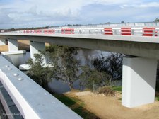
|  Bridge over the Murray River Bridge over the Murray River
One of the prominent features of the new Highway is the Murray River bridge with is located directly south of the Pinjarra Road Interchange, crossing Pinjarra Road and the Murray River.
|  Twin Spans over the Murray River Twin Spans over the Murray River
The twin structures are the longest on the project at 272 metres and were constructed using an incremental launch method to allow traffic on Pinjarra Road to continue to flow, and to lessen the construction impact on the environmentally sensitive river area.
|  Looking east along Pinjarra Road below Looking east along Pinjarra Road below
|
 Green Fields between Pinjarra Road and Murray River Green Fields between Pinjarra Road and Murray River
|  Murray River below the Twin Spans Murray River below the Twin Spans
Each bridge deck is comprised of 18 segments, which individually took an average of between 6 and 7 days to pur, stress and launch from the northern side of the Murray River.
|  Pinjarra Road below Pinjarra Road below
The 272 metre connection took just over 6 mths to reach the southern embankment, with 36 launches in total. More than 5,500 cubic metres of concrete and 815 tonnes of reinforcement was used for the bridge decks and combined, the two structures weigh approx 15,500 tonnes.
|  Seating for the Official Ceremony Seating for the Official Ceremony
Decorated Marquee on the Murray Bridge.
|
 Official Posters decorated the walls of the Marquees Official Posters decorated the walls of the Marquees
| 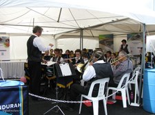 Mandurah Concert Band Mandurah Concert Band
Performing at the ceremony
|  Mandurah Concert Band Mandurah Concert Band
|  Python Display by Peel Zoo Staff Python Display by Peel Zoo Staff
|
 Part of Pinjarra Road Interchange to North-East Part of Pinjarra Road Interchange to North-East
|  Pinjarra Road heading east beyond the Trees Pinjarra Road heading east beyond the Trees
|  The Murray River below The Murray River below
|  View South towards Bunbury View South towards Bunbury
Walking down to board waiting bus for free tour of Iconic Artwork.
|
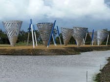
 Iconic Public Artwork beside Forrest Highway Iconic Public Artwork beside Forrest Highway
This artwork is comprised of eight cone-like structures, which represent a 'water marker' concept. The cones are situated on an island and are individually lit by solar power at night.
|  Closer view of Iconic Public Artwork Closer view of Iconic Public Artwork
Each cone is 5m in height and is constructed from marine-grade aluminium. Externally silver, the internal colour is blue which is visable through the cut out patterns in the structures.
|  Lone Tree was retained to compliment the Artwork Lone Tree was retained to compliment the Artwork
This old tree has nesting hollows for parrots.
|  Tree and Iconic Artwork on Islands beside Forrest Highway Tree and Iconic Artwork on Islands beside Forrest Highway
Note the sky...
|
 Rural Scene along Forrest Highway Rural Scene along Forrest Highway
Forrest Highway is named after Sir John Forrest (1847-1918), explorer and statesman.
|  Northerly view from Iconic Artwork Northerly view from Iconic Artwork
|  Artwork at Pinjarra Road Interchange Artwork at Pinjarra Road Interchange
Crossing the Murray River, the northern bridge wall abutment features grey and blue embossed swirl patterns representing the shimmering, flowing water endemic to the area.
|  Boat on Murray River below Boat on Murray River below
|
 Boats on the Murray River Boats on the Murray River
|  Pinjarra Road Interchange Pinjarra Road Interchange
East towards Pinjarra.
|  Wetlands Landscaping at Interchange Wetlands Landscaping at Interchange
To offset the environmental impact of the freeway’s construction a 23 hectare area adjacent to the road in Karnup has been transformed into dedicated wetlands to provide an extensive breeding habitat for waterbirds and attract fauna to the region.
| 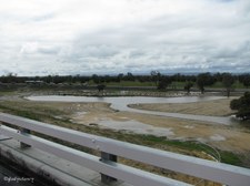 Wetlands at the Interchange Wetlands at the Interchange
Protection of native fauna has been achieved through the provision of underpasses to enable the animals to pass safely underneath the highway rather than attempt to cross it, causing danger to themselves and traffic.
|
 Politicians and V.I.P.'s pose for Photos under Ominous Sky Politicians and V.I.P.'s pose for Photos under Ominous Sky
Rain pelted down within a few minutes, luckily I was on the shuttle bus heading home.
| |
