
Lima - Plaza Mayor
Plaza Mayor - the heart of the historic center of Lima - is flanked on one side by the Palacio de Gobierno (President's Palace), one side by the Catedral and the other sides by commercial buildings.
| 
Lima - Archbishop's Palace
Constructed in 1924, the Archbishop's Palace is located on the same side of the Plaza Mayor as the Catedral.
| 
Lima - Archbishop's Palace
The Archbishop's Palace features several Moorish-style, wooden balconies. There are free walking tours (in English) of the downtown area that are given twice daily.
|

Lima - Archbishop's Palace Interior
The Palace has recently been reopened after extensive interior renovation work.
| 
Hostal El Patio - Lima
View of the courtyard at Hostal El Patio - where we stayed for a few nights. But the other recommended place we stayed was Hotel San Antonio Abad also in Miraflores area. Although El Patio has a more central location, San Antonio -with free airport pick-up and a terrific breakfast - just may edge out El Patio.
| 
Lima - Huaca Pucllana
An ancient ceremonial center - built about 400 AD - is located in the heart of the Miraflores area of Lima.
|

Lima - Huaca Pucllana
The adobe bricks are assembled in a V-shaped pattern to strengthen the wall's structure.
| 
Lima - Peruvian Hairless Dog
The Peruvian Hairless Dog has been around Peru for at least 4,000 years. They were revered by the ancient cultures as both guardians and guides of the dead.
| 
Lima - Peruvian Hairless Dog
They have often been used as animal bed warmers because the dogs have an unusually high body temperature. They also make excellent sight dogs for the blind. It was declared a distinct breed in 1986.
|

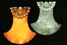
Lima - Larco Museum
Museo Larco contains the largest collection of Peruvian ceramics in the world. The mitt-shaped ceramic depicts sacrificial victims being tossed off a mountainside.
| 
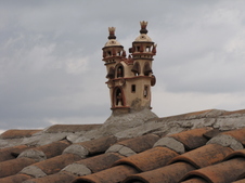
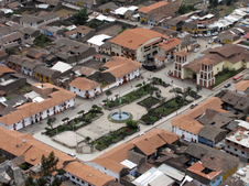
Cajamarca - Iglesia San Francisco
Nestled in the northern range of the Andes, Cajamarca sits at about 9,000 feet above sea level. The San Francisco church borders the Plaza de Armas (visible in the front of the photo). Although church construction began in the 17th century, it has only recently been completed.
| 
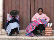
Cajamarca - Street scene
Cajamarca is often compared to Cusco - the Cusco of 30 years ago. Don Paco is our choice for the best eats in town. Find it at the street address: Puga 726.
|

Banos Del Inca - Outside Cajamarca
These thermal baths were being used by the Inca king Atahaulpa at the time Pizarro arrived in 1532. Only a 10-minute taxi ride from Cajamarca.
| 
Banos Del Inca - Outside Cajamarca
View across the thermal baths. There are private bathing rooms and public thermal pools. Click here to watch this steamy video
| 
Banos Del Inca - Outside Cajamarca
Sign above an outdoor thermal bath warning caution - about 106 degrees Fahrenheit. Click here to watch a bubbling video
|

Los Pinos Inn - Cajamarca
The place we stayed - Los Pinos Inn - is a gilded mirrored oddity with superb rooms on its top floor. A view of one of common area parlors - complete with a suit of armor and a deer in the fireplace.
| 
Cumbe Mayo - Outside Cajamarca
A few miles southwest of Cajamarca is the highland area known as Cumbe Mayo. The area contains many strange rock formations collectively known as the Bosque de Piedras (Forest of Stone).
| 
Cumbe Mayo - Outside Cajamarca
Constructed in approximately 1000BC, the pre-Inca canal/ aqueduct may be among some of the oldest man-made structures in South America. The canal runs for about 5 1/2 miles.
|

Cumbe Mayo - Outside Cajamarca
Cumbe Mayo (Quechua for "well made water channel") carried water - through a series of tunnels and canals - from the Atlantic to the Pacific watershed (from the east to west side of the Andes range).
| 
Cumbe Mayo - Outside Cajamarca
Local woman selling food and drink the Cumbe Mayo area.
| 
Cajamarca - The Ransom Chamber
El Cuarto del Rescate was the room where Inca leader Atahaulpa was imprisoned by the Spanish. It is the only surviving Inca construction in Cajamarca. The room was to house Atahaulpa's gold ransom; this has since been disputed.
|

Ventanillas de Otuzco
Located a few miles further from Cajamarca than the Banos, the "windows" were actually pre-Inca burial chamber.
| 
Ventanillas de Otuzco
The tombs, where Cajamarca chiefs were supposedly buried, were carved into the hillside's volcanic stone.
| 
Ventanillas de Otuzco
|

Ventanillas de Otuzco
The Ventanillas can be seen via a well marked walking path in from the main roadway.
| 
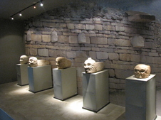
Museo de las Tumbes Reales de Sipan - Lambayeque
Renowned as one of the best museums in South America, Museo Tumbes Reales de Sipan is a recent addition to Peru's museum scene. It is built in a style reminiscent of a Moche pyramid.
| 
Museo Tumbes Reales de Sipan - Lambayeque
In 1987, an undisturbed royal tomb was found on the outskirts of Chichlayo. One enters the museum on the top floor, only to work your way down to the tomb on the bottom floor.
|
Museo de las Tumbes Reales de Sipan - Lambayeque
| 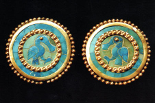
Museo Tumbes Reales de Sipan - Lambayeque
Earrings or - more accurately - ear studs from the royal tomb.
| 
Museo Tumbes Reales de Sipan - Lambayeque
|

Museo Tumbes Reales de Sipan - Lambayeque
Gold spider necklace. The reverse design has serpent and cross forms.
| 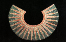
Museo Tumbes Reales de Sipan - Lambayeque
Beaded neck piece.
| 
Mercado Modelo - Mercado de Brujos - Chiclayo
The entrance to the witches market in the Mercado Modelo in Chichlayo. It is one-stop shopping for any local shaman.
|

Mercado Modelo - Mercado de Brujos
A wide assortment of charms and amulets are available as well as hallucinogenic cacti (San Pedro cacti) as pictured here.
| 
Mercado Modelo - Mercado de Brujos
They have a medicine or an herb for whatever ails you - from pain relievers to love potions.
| 
Tucume - Valley of the Pyramids
This area - about 20 miles north of Chichlayo - is home to 26 pyramids, in various states of erosion.
|

Tucume - Valley of the Pyramids
El Purgatorio (the place to purge) has the best views in the area - as can be seen from this vulture's point of view. This spot is still used by local curanderos (healers) for shamanic rituals. Tucume has a reputation among locals as magical place.
| 
Tucume - Valley of the Pyramids
All were made with adobe (mud, straw and water) bricks. The Sican culture began here in about 1100 AD. There is evidence that the Sican people traded with others in what is modern-day Ecuador and Columbia. They were expert seafarers.
| 
Tucume - Valley of the Pyramids
At its peak in the 13th and 14th centuries, Tucume was probably a pilgrimage site. It was later conquered by the Chimu and the Inca. But by the time the Spanish arrived, it was already in ruins.
|

Tucume - Valley of the Pyramids
An owl in the woods bordering Tucume. Thor Heyerdahl found at Tucume inspiration to support his theory that there was a link between coastal Peruvian cultures and south Pacific peoples.
| 
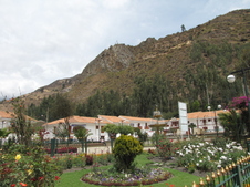
Lambayeque
About 7 miles north of Chiclayo, is the quiet, suburban town of Lambayeque - home to two world-class museums and to the dessert sweet known as a King Kong. A view of the church off the main square.
| 
Hosteria San Roque - Lambayeque
Hands down. The best place to stay in Lambayeque - Hosteria San Roque. Charming and quiet - a converted colonial house. Only a 10-minute taxi or combi ride from Chiclayo and within easy walking distance to Lambayeque's great museums.
|

Chan Chan - Trujillo
Chan Chan was the capital city of the Peru's largest pre-Inca empire - home to the Chimu people. The site encompasses about 5,000 acres. It was declared a UNESCO World Heritage site in 1986.
| 
Chan Chan - Trujillo
The main plaza where religious ceremonies were held. The altar -seen in the center of the photo - was where human sacrifices took place.
| 
Chan Chan - Trujillo
The walls are carved with seemingly endless rows of sea otters - a traditional fertility symbol since Moche times - and cormorants.
|

Chan Chan - Trujillo
It was once home to between 30,000 to 60,000 people. The carved adobe walls towered to 30-feet tall and were elaborately painted. Chan Chan has been eroded by numerous floods and El Nino rains.
| 
Chan Chan - Trujillo
At the center of the complex is a giant pool of water that once served as the main water supply for the complex. Chan Chan was built around 1300 AD and later abandoned around 1470.
| 
Chan Chan - Trujillo
At the center of the site are 10 royal compounds (ciudadelas). Only the upper classes were allowed into these palaces. Once the king died, the palaces were sealed off and converted into mausoleums.
|

Chan Chan - Trujillo
Unlike the Inca, the Chimu worshipped the moon over the sun because the moon was out both day and night and also controlled the nearby ocean. Detail of pelican relief.
| 
Trujillo - Downtown
After conquering Peru, Pizarro came to Trujillo in 1535 and named the city after the town of his birthplace in Spain. Later, it was the first city to declare itself independent of Spain in 1820. Trujillo has a population of nearly 300,000.
| 
Museo Casinelli - Trujillo
One of the best museums in town is located in the basement of Mobil gas station - the Museo Casinelli. The museum contains an outstanding array of ceramic treasures. Click here to listen to the demo
|

Museo Casinelli - Trujillo
The pieces were acquired by Senor Casinelli (with the help of local huaqueros - tomb robbers) over the past 40 years.
| 
Museo Casinelli - Trujillo
Moche, Chimu, Nasca, Huari and Inca cultures are all represented here.
| 
Museo Casinelli - Trujillo
But Senor Casinelli also has a special locked section of erotic Moche ceramics. (Sorry, this is not a picture of those.) But this is a curious ceramic of a bearded man (possibly a Viking?) which is unusual in pottery of that time.
|

Museo Casinelli - Trujillo
Senor Casinelli can often be found at a desk at the entry to the museum. He seems always willing for a photo op. Pictures of his younger self and his wife are hung above him on the wall.
| 
Museo de Zoologia - Trujillo
Rabbit - with plastic, orange carrot - on view at the Zoology museum in Trujillo.
| 
Huaca del Sol - Trujillo
Huaca del Sol and Huaca de la Luna (known in the area as the Huacas de Moche) were built by the Moche people between 1 and 700 AD. Huaca del Sol is the largest adobe structure in the Americas.
|

Huaca de la Luna - Trujillo
The adobe bricks utilized in the construction of the Huacas often contained the maker's (or family's) mark to account for their tribute to the elite.
| 
Huaca de la Luna - Trujillo
It has been estimated that is required between 50 and 140 million adobe bricks to complete the pyramid.
| 
Huaca de la Luna - Trujillo
The painted friezes are that most striking feature of the Huaca. The symbol known as Ai-Apaec is a serpent (symbol of the earth) also known as the master between life and death. It is a stylization similar to earlier Chavin feline representations.
|

Huaca de la Luna - Trujillo
The Huaca was built layer upon layer - each ruler building on top of the other structure. The building is about 10 stories high. In this photo, archeologists and restorers are working on one of the largest paintings.
| 
Huaca de la Luna - Trujillo
| 
Huaca de la Luna - Trujillo
On the north face of the huaca, archeologists have uncovered a multi-storied horizontal mural depicting soldiers in the midst of a victory dance.
|

Huanchaco
This seaside fishing village - about a 10 minute taxi ride from Trujillo - has become a destination for travelers looking for a more laid-back alternative to a stay in Trujillo.
| 
Huanchaco
The pier is the perfect spot for watching the sunset in Huanchaco. For a splurge, we stayed in one of the ocean-view suites at Hostal Caballito de Totora.
| 
Huanchaco
The town has become a surfer's mecca: surfing schools, surf shops and even surfer hostels.
|

Huanchaco
Fishermen still use these reed boats - caballitos (little horses) de totora (of reed) - to fish the way their ancestors did nearly 2,000 years ago.
| 
Huanchaco
The fishermen of Huanchaco are one of the few remaining peoples along the northern coast that remember how to make and use the reed boats. The reeds for the boats are grown at the northern stretch of the town.
| 
Huanchaco statue
Each boat only last for a few months before it becomes too waterlogged to continue to be used.
|

Ballestas Islands
On route to the Ballestas Islands, boat passengers first past this massive 400+ foot high trident form carved into the hillside. The exact age or function of the symbol is still unknown.
| 
Ballestas Islands
Although some have suggested that it was carved as a navigational aid, most now believe it was a pre-Inca ritual object to worship the setting sun.
| 
Ballestas Islands
The Ballestas Islands - off the west coast of Peru near Ica - are often called the Galapagos Islands of Peru.
|

Ballestas Islands
Ballesta is a Spanish word meaning "crossbow" - possibly the harpoon-like weapon fisherman originally used to hunt the islands' animals.
| 
Ballestas Islands - Penguins
There are many islands in the Ballestas group - some no larger than a rock outcropping or two; others as large a couple of football fields.
| 
Ballestas Islands - Seals
Seals, penguins, boobies and cormorants are all part of the wildlife that can be seen from the tourist boats that circle the islands. Visitors are not allowed to walk on the islands.
|
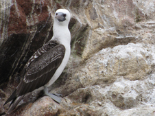
Ballestas Islands - Booby
The Booby's name was possibly based on the Spanish slang term bubi, meaning "dunce", as these tame birds had a habit of landing on board sailing ships, where they were easily captured and eaten.
| 
Ballestas Islands
Guano Island. The roosting birds can cover an island like this with guano (originally a Quechua word). Guanos is a highly prized fertilizer than contains 20 times more nitrogen than cow manure.
| 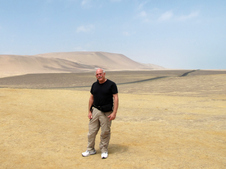
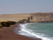
Paracas National Reserve
The Paracas Reserve was set up on 1975 to preserve about 827,000 acres of desert land along the Peruvian coastline south of the of the Ballestas Islands.
|
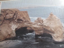
Paracas National Reserve
The Paracas coastline has been compared to the rugged coastlines of Oregon and northern California except that it is a desert. This is a view of La Catedral rock formation before it was destroyed (separated) by a devastating earthquake in 2007.
| 
Paracas National Reserve
The earthquake of 2007 destroyed the nearby historic city of Pisco which is still reeling from that natural tragedy.
| 
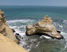
Paracas National Reserve
The southwesterly ocean winds blast the Paracas coastline each afternoon. The winds - along with the pounding surf - have helped sculpt the dramatic coastline.
|

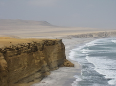
Paracas National Reserve
The cool Hulmboldt current ocean winds hit the warm coastline and create a moisture-laden fog (garua) that blankets the area during the mornings mainly between July and October.
| 
Paracas National Reserve
Playa Colorado (Red Beach) on the road to the fishing village of Lagunillas.
| 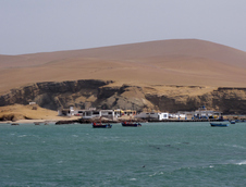
Lagunillas - Paracas Reserve
The tiny fishing village of Lagunillas is the lunch destination of most day-trippers to the Paracas reserve.
|

Paracas National Reserve
From 1,000 BC the coastline's rich fishing waters sustained the Paracas culture until it was subsumed by the Nasca culture in about 200 AD.
| 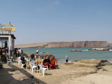
Lagunillas - Paracas Reserve
A handful of beach-side restaurants serve the tour group lunchtime crowds. In the town of Paracas we stayed at Posada del Emancipador - a servicable mid-range option along the main Paracas road.
| 
Lagunillas - Paracas Reserve
Pelicans wait outside the restaurants' kitchens for any scraps or droppings.
|

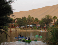
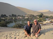
Huacachina
According to local lore, the desert oasis of Huacachina came into being when a princess was bathing, looked in her mirror and saw a man, dropped the mirror and the mirror turned into the lagoon. (Question: So what body of water was she bathing in before she dropped her mirror?)
| 
Huacachina
During the 1940s, this town was an elegant resort for the Peruvian elite. Now, this town of only 200 persons, is one of the top 5 chill-out spots for the backpacker set along the Peruvian Gringo Trail.
| 
Huacachina
Huacachina's lagoon is featured on the back side on one of their bills: the $50 sole note.
|
Huacachina
The lake's subterranean water source has grown erratic but has been supplemented by water pumped from nearby artesian wells.
| 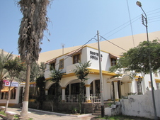
Huacachina
The Hotel Suiza probably had the best and quietest spot in town. It is located lagoon-side with sands lapping at its rear yard.
| 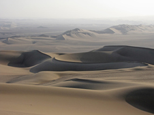
Ica Desert
The Ica Desert is one of the world' richest hunting grounds for marine fossils. The area used to be covered with sea water and marine life.
|
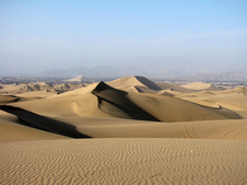
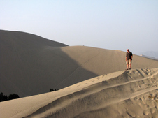
Ica Desert
Huacahina, in the heart of the Ica Desert, is home to some of the world's tallest dunes.
| 
Ica Desert
| 
Ica Desert
|
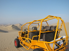
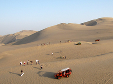
Arenero (Dune Buggy) - Huacachina
Most tourists opt for a high adrenaline dune buggy ride through the desert. Click here to see a short video of our ride.
| 
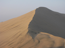
Ica Desert
A view of sand boarders waiting to go down one of the 50 degree-angled dunes.
| 
Sand Boarding - Huacachina
Sand boarding is the favorite pastime of tourists to the area. We were no different.
|

Sand Boarding - Huacachina
Most tourists opt to go down sled-style on the sand boards. It's safer.
| 
Ica Desert
| 
Huacachina
The mud from the lake is supposed to have curative powers - curing arthritis, asthma and rheumatism.
|

Nasca Airport
5-seater planes waiting to take off for the typical 35-minute flyover the Nasca Lines.
| 
Nasca Lines
The spider monkey as viewed from above. It is speculated that the lines were created by the Paracas and Nasca cultures between 900 BC and 600 AD.
| 
Nasca Lines
The whale. Most of the lines were made with a single continuous line - mainly by clearing away the brush and large stones to reveal the fine sand underneath.
|

Nasca Lines
Spaceman. The lines were possibly created as some kind of agricultural calendar, water locater or ritual paths to connect sacred power spots (huacas).
| 
Nasca Lines
The condor. There are over 70 animal or plant line drawings in the area but most are not perceptible from the ground. There are also some 800 straight lines and 300 geometric figures (geoglyphs) that have been discovered.
| 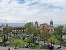
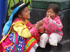
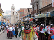
Ayacucho
View of the Plaza de Armas in Ayacucho (meaning "Purple Soul" in Quechua). During the 1980's and 1990's it was the home of the terrorist group Sendero Luminoso ("the Shining Path").
|
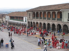
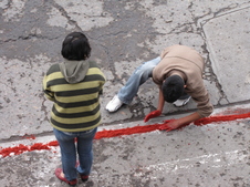
Ayacucho
The town of 151,000 sits at an elevation of 9,200 feet in Peru's central Andes mountains. On this morning, children were gathering to create sawdust carpets in commemoration of their school anniversary.
| 
Ayacucho
Early morning view of carpet creation from the balcony of the restaurant of the hotel Via Via. Via Via has the best food and accommodations in town.
| 
Ayacucho
The first language of many of the residents is Quechua. Spanish, though, is widely spoken.
|
Ayacucho
The first language of many of the residents is Quechua. Spanish, though, is widely spoken.
| 
Ayacucho
| 
Ayacucho
Ayacucho was the seat of the Wari Empire which dominated this area of Peru between 500 and 1000 AD. They built of the roadways and stone buildings that the Inca later possessed.
|
Ayacucho
Ayacucho is one of Peru's more artistic towns. Some of the best huayno singers originated here. Guitar playing - necessary for serenading - is an essential skill for most Ayacucho men.
| 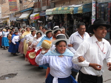
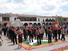
Ayacucho
This group of singers, dancers and musicians snaked throughout the city during most of the afternoon.Click here to listen and see the parade
| 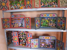
Retablo Studio
A view of the retablos (wooden boxes containing 3-dimensional scenes) on display in the studio of Luis and Julia Huamani Rodriguez in the crafts barrio of Santa Ana in Ayacucho.
|

Retablo exterior
The word retablo comes from the Latin "retro-tabulum" (meaning behind the table or altar) because retablos were originally placed behind the altars in Catholic churches. Most retablos feature religious scenes (the Nativity, Noah's Ark, etc.) but many recreate everyday scenes.
| 
Corn Harvest Retablo
Luis and Julia, a husband and wife retablista team, have a studio above their house. Luis sculpts the figures; Julia paints them.Watch video of Luis sculpting.
| 
Corn Harvest Retablo Close-Up
The clay for the figures is made of flour, plaster, chalk, marble dust and water. Depending on the weather they could take a few hours to a day to dry.
|

Corn Harvest Retablo Close-Up
Once dry, Julia paints them using handmade cat's hair brushes and an acrilyic paint. The figures are then glued in place and then painted with a clear gloss.
| 
Jungle scene retablo
Julia was from the San Miguel area of Ayacucho but her family fled to Iquitos (the northern jungle area of Peru) during the years of the Shining Path.
| 
Retablo Studio
Luis and Julia also create clay masks, ornaments and skeleton figures. The skeleton beings are a melding of a Mexican-inspired figures with traditional Andean dress.
|

Jungle retablo detail
Julia returned to Ayacucho in 1996. Watch Luis paint an exterior of a retablo.
| 
Local musicians retablo
Luis and Julia also take pedidos (requests) for specially designed retablos. When we were at their studio, they had just finished a school room retablo scene for a teacher.
| 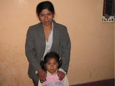
Julia Huamani Rodriguez
Julia and one of her daughters. Luis learned his craft in the Lima retablo studio of Claudio Jimenez. Julia has been working on retablos with her husband for about 10 years.
|
Huari
Historians believe that the site used to house some 50,000 people just over 1,000 years ago.
| 
Huari
A stone sculpture at the Huari (Wari) site about 14 miles from Ayacucho.
| 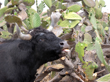
Huari
Prickly pear cactus (tuna) appears to be a treat for the local roaming cattle at the Huari ruins.
|
Quinua Church
The town of Quinoa, about 23 miles outside of Ayacucho, is a pleasant cobblestone village.
| 
Quinua Church
Miniature ceramic churches are placed on most of the rooftops of the buildings for good luck.
| 
Quinua
Quinoa was the site of many encounters between the militia and the Shining Path. Many residents felt forced to flee to avoid the violence.
|

Huaraz
Rooftop view of Huaraz from the comfortable hostal Albergue Churup. Huaraz is not a pretty town but when the clouds lift, its mountain surroundings reveal its appeal.
| 
Lake of Querococha - near Huaraz
On the road from Huaraz to Chavin, this beautiful lake (known as the "lake of teeth" in Quechua) could be glimpsed from the bus. The lake got its name from the jagged, teeth-like rock formations that surround it.
| 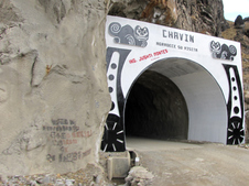
Tunel de Cahuish
This tunnel - at 15,000 feet - is the only route through the mountains to travel by bus from Huaraz to Chavin.
|
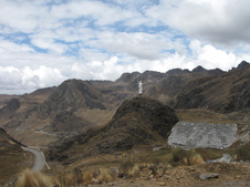
Statue of Christ - Callejon de Cochucos
After passing through the Tunel de Cahuish from Huaraz, this view is the first glimpse of the valley. A Christ statue, built by Italian missionaries, dominates the vista.
| 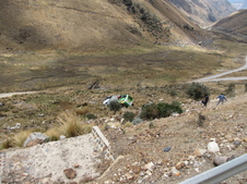
Curva del Diablo/Salvate Si Puedes
On the road between Chavin and Huaraz, a bus had slipped over the side of the road the night before. One curve in the road is known as Curva del Diablo ("the devil's curve") and the other Salvate si puedes ("Save yourself if you can").
| 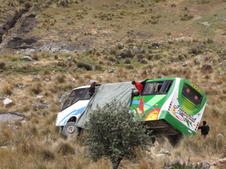
Curva del Diablo/Salvate Si Puedes
No one was killed but the number of injured was unknown. Unfortunately this is a not so uncommon occurrence on these mountain roads.
|
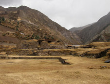
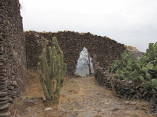
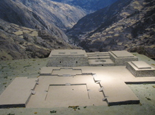
Chavin de Huantar Ruins
A UNESCO World Heritage site since 1985, Chavin de Huantar is the only major structure left from the Chavin culture. The temples were built between 1200 BC and 800 BC. There is a vast network of tunnels beneath the buildings.
| 
Chavin de Huantar Ruins - Replica
| 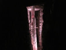
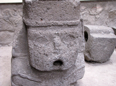
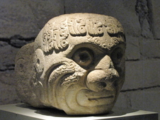
Chavin de Huantar Ruins
The Lanzon de Chavin - in the "basement" of the Chavin ruins - is a carved, low-relief stone obelisk depicting a person with snakes emanating from their head and a grotesque set of fangs.
|
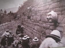
Chavin de Huantar Ruins
A photo of a photo - found at the Museo Nacional in town - shows one wall of the ruins that contains several large projecting tenons. The site has withstood many earthquakes and periodic mudslides over the years.
| 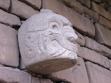
Chavin de Huantar Ruins
The mortar-less stone walls used to contain many tenons (projecting keystones representing human/animal heads in a hallucinogenic state?) but now only one remains in place. The rest of the recovered tenons can be found at the new, local museum.
| 
Museo Nacional de Chavin
The tenons were moved to museum's indoor location to help better preserve them. The Chavin people appeared to worship three major god-forms: the moon (represented by a fish); the sun (shown as an eagle or hawk) and a creator, normally depicted as a fanged cat.
|
Museo Nacional de Chavin
The Museo Nacional, opened in 2009, houses a small but wonderfully displayed collection of the Chavin tenons. The museum also contains the Tello Obelisk that had been originally housed in Lima.
| 
Chavin
Chavin, a small Andean town of 2,000 inhabitants, is nestled in a valley at an elevation of about 11,000 feet. This is a view of the Plaza de Armas from the hillside above the town.
| 
Chavin
View of the Plaza de Armas and the hillside above. In town, the most comfortable place to stay is La Casona - overlooking the main square.
|
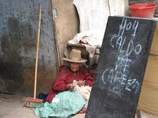
Chavin
In the market at Chavin, a woman selling Caldo de Cabeza - "soup of the head" (the head of what?).
| 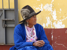
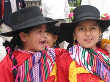
Carhuaz
On Sunday, the market day, Carhuaz comes alive. Many of the women wear wide-brimmed hats - often adorned with ribbons to denote their marital status (blue is for married; red is for single).
| 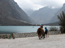
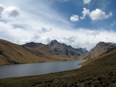
Llaganuco Lakes
There is no easy way to get to these beautiful mountain lakes. It is a 2-hour, bumpy van-ride from the town of Yungay - about 1 1/4 hours from Huaraz - along a narrow dirt road.
|
Llaganuco Lakes
A view of Chinan Cocha - the first lake in the Llaganuco series - was named after a legendary princess. Row boats can be rented. There are also several picnic areas.
| 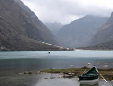
Llaganuco Lakes
View of Chinan Cocha. On a clear day, several snow-capped mountains would be visible. Unfortunately, rain and clouds prevailed.
| 
Llaganuco Lakes
The lakes are a great place for spotting the quenual tree - a small, wind-bent tree that is highest-growing tree in the world. It can thrive in altitudes over 15,000 high.
|

Llaganuco Lakes
The Cordilleras Blancas - an arm of the Andes - is the second highest (after the Himalayas) mountain range in the world. It contains 22 summits that stretch over 20,000 feet into the sky.
| 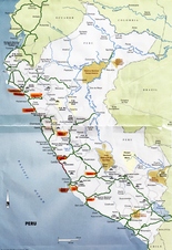
Peru Map
Peru map highlighting the destinations visited.
| 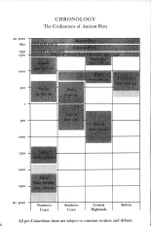
Timeline
Timeline of the ancient cultures of Peru.
|