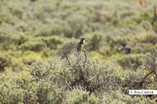
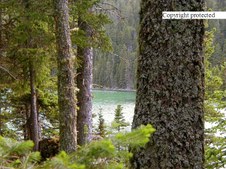
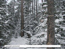
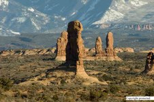
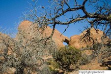
1
IMG 8922
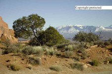
This squirrel isn't dumb. He went up on this bush so he could see around as to what and who was in the neighborhood...it's survival isn't it? He was in Tetons National Park.
| 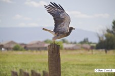
2
IMG 6636- Swainson's Hawk
He was on the verge of take off when I got this photo!! September 9, 2010
| 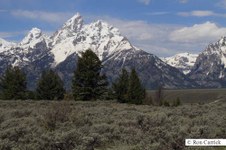
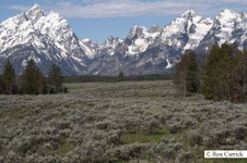
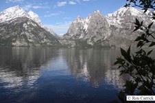
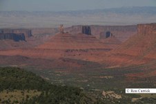
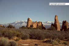
3
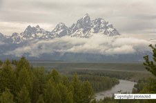
IMG 3145
13,770 ft Grand Teton Peak in Tetons National Park this Past June 15, 2010
12,804 ft.Middle Teton on right, 12,828 ft. Mount Owens on right.
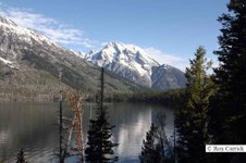
| 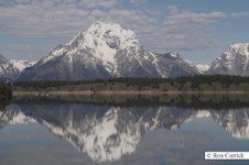
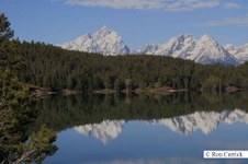
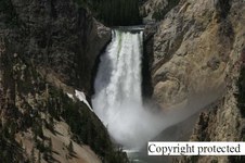
4
IMG 3065
Tetons National Park - 12,605 ft. Mount Moran across Jackson Lake
|
5
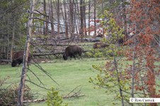
IMG 3047
Middle Teton, Grand Teton, Mount Owen Peak, on the left - not sure of the other peaks on the right. If anyone knows what they are please let me know? Thanks!
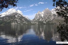
| 
6
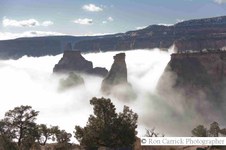
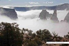
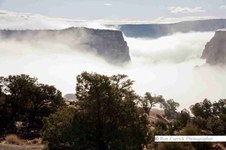
IMG 3033
Peaks looking across Jenny Lake
| 
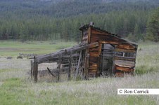
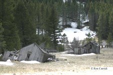
7
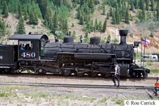
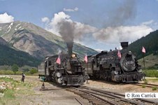
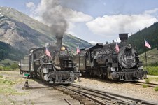
IMG 3031
11,144 ft. Rock Chuck Peak NW over Jenny Lake
| 
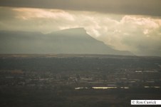
8
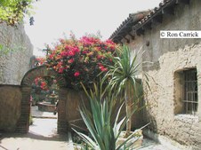
IMG 3030
Rock Chuck Peak 11,144 ft - looking north west over Jenny Lake
|
9
IMG 3016
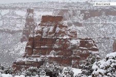
Mount St John 11,430 ft - across Jenny lake on right. Again not sure of the other peaks
| 
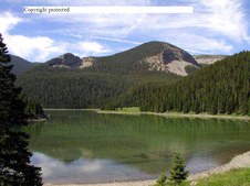
10
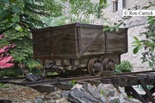
IMG 3013
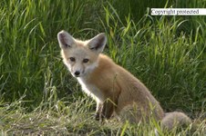
Mt St John on right again
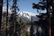
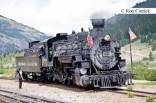
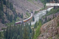
| 
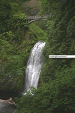
11
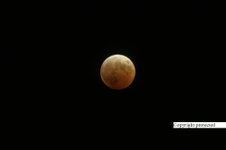
IMG 3063
Middle Teton, Grand Teton, and Mount Owen across Jackson Lake. Last Tetons Photo
| 
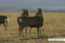
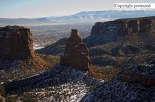
12
IMG 7176
Mt. Garfield near Grand Junction, Colorado June 6,2010
|
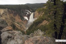
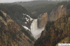
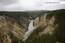
13
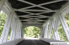
IMG 2153
Lower Yellowstone Falls
| 
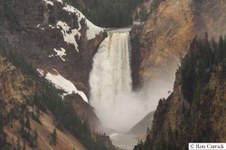
14
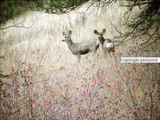
IMG 2156
Lower Yellowstone Falls - 06_02_2010 close up.
| 
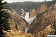
15
IMG 2056
Lower Yellowstone Falls June 2010 from another viewing area than previous photo's
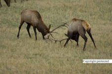
| 
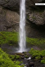
16
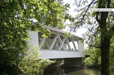
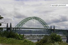
IMG 2059
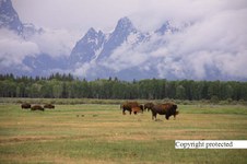
Lower Yellowstone falls another view point close up 2010.
|
17
IMG 2079
June 2010
| 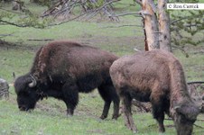
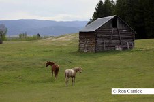
18
IMG 2037
Buffalo in Yellowstone summer 2010
| 
19
IMG 2029
| 
20
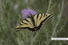
IMG 1800
Teton Buffalo June 2010
|
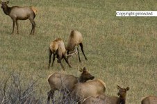
21
IMG 7037 copy
Castle Valley Rock - in the Castle Valley east of Moab,Utah
| 
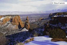
22
IMG 2792
Almost see the ground near the bottom of Independence Monument in Colorado National Monument near Fruita, CO,September 2009
| 
23
IMG 2787
See that thing on the left...... I went up close with the 100-400 lens from the location before this and you'll see it up close in a few more shots.
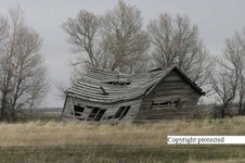
| 
24
IMG 2796
Framed.......
|
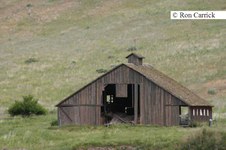
25
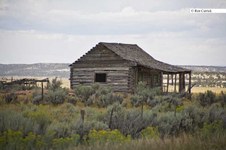
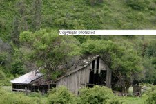
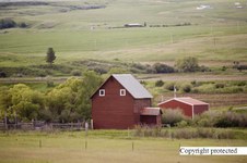
152 5254 RJ copy
Old chicken house among a bunch of abandoned ranch buildings on high way 200 between Missoula and Ovando in MT. Taken: May 20, 2004
| 
26
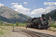
IMG 2927 copy
Narrow Gauge Steam Locomotive at Silverton, Colorado July 4,2008
| 
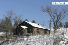
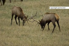
27
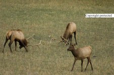
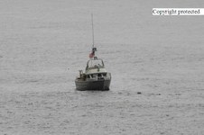
233 3334 RJXcopy
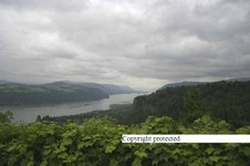
These guys were busy for a while back and forth same as previous on October 7, 2005 at the Charles M. Russell Wildlife Refuge viewing area along the Missouri River near north central Montana.
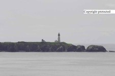
| 
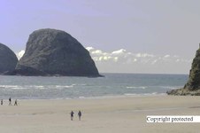
28
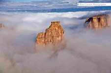
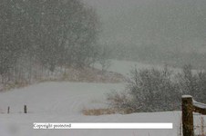
IMG 2930 copy
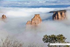
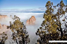
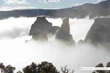
|
29
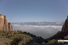
IMG 7182 1
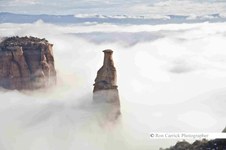
A view looking north from just inside the Monument across the fog covered Valley, With Fruita, Colorado below the blanket of fog.
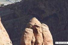
Taken October 2, 2007
| 
30
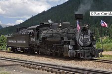
IMG 2932.2 copy
Narrow Gauge RR Steam Locomotive - July 4th 2008
| 
31
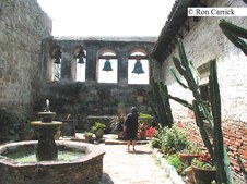
P4121125.copy
Part of the San Juan Capistrano Mission accessible from the court yard. Taken April 12, 2001
| 
32
IMG 2939 copy
Pair of N.G. RR Steamers
|
33
200_0095 RJXcopy
Part of the bunch Mule doe just out side the north west city limits of Lewistown, Montana
Taken: Oct. 26,2004
| 
34
IMG 2941
One more shot of the Steamers
| 
35
IMG 0524 copy
Independent Monument in a snow storm. Another view.........Taken February 28,2007
| 
36
IMG 9443 copy
Getting ready to back up and hook up
|
37
1 P7170591xcopy
This one won 1st place in it's catagory at a fair.
This is a view of Crystal Lake 20 miles south of Lewistown, Mt. in the Big Snowy Mountains. Taken: July 17, 2003
| 
38
IMG 9495 copy
An old ore car display in down town Silverton near a business
| 
39
165_6501 RJXcopy
My favorite pose of a Fox Kit. Taken: June 19, 2004 south of Moore, Montana
| 
40
IMG 9488 copy
The Narrow Gauge Locomotive leaves Silverton, Co with a load of tourists headed for Durango, Colorado.
|
41
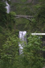
151 5160 copy
Can't remember the name of this Pretty Water Falls but it is just west and Near Multinomah falls. Taken: May 19, 2004
| 
42
200_0016 RJXcopy
The moon taken October, 27, 2004
| 
43
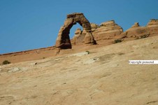
245 4585 RJ copy
Delicate Arch in Arches National Park , near Moab Utah. Notice the size of the person standing to the left of the arch?
Taken: February 23, 2006
| 
44
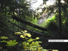
P9244264 copy
These trees are all Cedar, the yellow/green leaves in the near ground are called Devils Claw. The large fallen tree bridges the small canyon it fell in. It was dark because of the heavy over growth. It was a pretty valley with steep sides. This location is just west of Coville, Washington which is in the N.E. corner of the state.
Taken: September 9, 2003
|
45
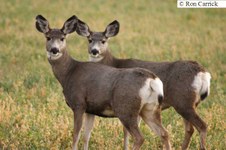
198 9830 copy
Two female Mule deer on Beaver Creek near Lewistown, Montana. Taken Oct 10, 2004
| 
46
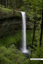
147 4774 RJ.copy
177 Ft. Drop South Falls - Silver Falls State Park - Oregon May 9, 2004
| 
47
233 3392 RJXcopy
Hmmmm what was that? More wild life refuge photo's. This guy was also at CMR Refuge in Central Montana October 7, 2005
| 
48
P4121127.copy
Inside the area just past the arch at the San Juan Capistrano Mission accessible from the court yard. Taken April 12, 2001
|
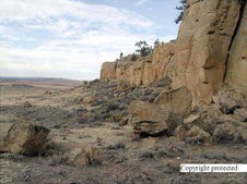
49
PA250032Xcopy
I call this Sand Stone Picture window. This photo was taken on the top of the Plateau near Wennett, MT.
Taken: Oct 25, 2000
| 
50
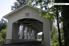
148 4848 RJ.up copy
Crabtree Creek (Larwood) Covered Bridge
County: Linn
Stream: Crabtree Creek
Truss Type: Howe
Bridge Length (ft): 105
Year Built: 1939. Taken May 12, 2004
| 
51
P6240036.CrystalXThroughXTheXFir
This photo was taken in June of 2000 at Crystal Lake also.
| 
52
148 4844 RJupXcopy
Crabtree Creek (Larwood) Covered Bridge
County: Linn - State Oregon
Stream: Crabtree Creek
Truss Type: Howe
Bridge Length (ft): 105
Year Built: 1939
Photo taken: May 12, 2004
|
53
148 4849 RJ.up copy
Crabtree Creek (Larwood) Covered Bridge
County: Linn - State Oregon
Stream: Crabtree Creek
Truss Type: Howe
Bridge Length (ft): 105
Year Built: 1939
Taken: May 12, 2004
| 
54
PA260028Xcopy
They were grazing on the hill side. Mom and young Mule deer, 6 miles up Spring Creek from Lewistown then on towards Heath, Montana.
Taken: October 26, 2000
| 
55
P2110012 copy
Deep woods at Show Down Ski Area.... Big Belts of central Montana south of Great Falls, MT. Taken: February 11, 2001. I with snow shoes on went into those woods while a friend snow boarded the slopes. Haven't been back there since that day.
| 
56
222 2289 RJ B UPXcopy
Still closer with spray and snow on the left. This was June 30, 2005
|

57
236 3610 copy
Mallard Drake at Zoo Montana, Billings Montana. He was a wild duck swimming in the stream that runs through the zoo. November 14, 2005
| 
58
115 1552 RT8 copy
Castle Creek... S.E of Lewistown, Montana 10 miles or so ... it was snowing as you can see.
Taken: Oct. 30, 2003
| 
59
PA250002Xcopy
Bottom of a sand stone type plateau.. near Winnett, Montana
Taken: Oct 25, 2000
| 
60
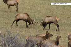
233 3311 RJXcopy
More clanking of antlers and beating of hooves with cows near by. Same place and time as previous photo. Taken: October 7, 2005
|
61
151 5182 RJXcopy
Lower Multinomah Falls east of Portland, Or.
Taken: May 19, 2004
| 
62
149 4953 RJ copy
This is the Bridge at New Port Oregon.
Taken: May 16, 2004
| 
63
5D IMG 0775 copy
Buffalo in Teton National Park on June 14, 2006
| 
64
207 0774 RJ .copy
Just out of Lewistown, Montana up Spring Creek 2 miles.
Taken the winter of 2004
|
65
246 4660JR copy
More Towering rock out crops with La Sal Mountain back drop. Arches National Park. February 23, 2006
| 
66
149_4990_RJ_copy
I was pretty close and this seagull wasn't sure what to do as I slowly walked towards it snapping pictures. It flew shortly after I took this photo. I was to close for it's comfort I guess.
Taken: May 16, 2004 on the Oregon Coast
| 
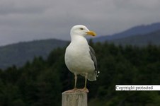
67
152 5222 RJ copy
This is west of Lewiston, Idaho on high way 12 in Washington State. Taken: May 19, 2004
| 
68
233 3335 RJXcopy
The one on the right has 5 points on one side and six on the other. The other has six on both sides. The with 5 points on one side was a bit bigger than the other bull. They were pretty evenly matched though. Taken: October 7, 2005
|
69
146 4670 RJ.copy
Old hay barn near Ovando, MT on Highway 12 in the summer with horses posing. Taken: May 20, 2004
| 
70
5D 0803 copy
Mountains looking up a Yellow Stone Valley out of the park. Taken June 14,2006
| 
71
134 3459 copy
These old buildings are at Maiden and old mining town 22 miles north of Lewistown, Montana - Taken: March 28, 2004
| 
72
233 3309 RJXcopy
Contact made, but not to much action. Same place and time as previous photo.
|
73
5D 0873 copy
Lower Yellowstone Falls one stop below on the west side.
June 14, 2006
| 
74
246 4624 JR copy
La Salle Mountains from Arches National Park, taken February 23, 2006
| 
75
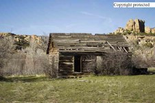
IMG 7002 copy
This old log house/cabin is just south of the Glade Park store between Fruita, Colorado and the Utah border.
Taken August 30, 2007
| 
76
5D 0734 copy
Grand Teton in Teton National Park with the Snake River below. Taken June 14, 2006
|
77
172 7222 RJXcopy
Northeastern Swallow Tail on a Canadian Thistle bloom
Taken: Near Lewistown, Montana on July 26, 2004
| 
78
151 5185 RJXcopy
Lower Multinomah Falls, taken through the foliage. Taken:May, 19, 2004
| 
79
DPP 0001 copy
Independent Monument - Taken: January 30,2007
| 
80
233 3302 RJXcopy
They lowed their heads in a challenge while as cow elk casually strolled by. Taken: October 7, 2005 at Slippery Anne Wildlife Viewing area in the Charles M. Russell Wild Life Refuge in the Missouri Breaks of Montana along the Missouri River in Montana. Taken October 7, 2005
|
81
246 4601 RJ copy
Unique view of Skyline Arch. Taken: Feb. 2006, Arch in Arches National Park , near Moab Utah. Taken: February 23, 2006
| 
82
P4121126.copy
A part of the San Juan Capistrano Mission accessible from the court yard. Taken April 12, 2001
| 
83
246 4622 JR copy
La Sal Mountains with rock formations in the fore ground. Arches National Park, near Moab, Utah.
February 23, 2006
| 
84
238 3827 RJ copy
This rock is over 400 feet tall. called Independence Monument it is in Colorado National Monument in western Colorado. Taken January 20,2006
|
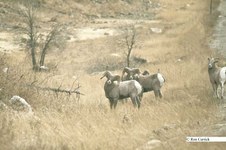
85
IMG 1716.2 copy
4 Rocky Mountain sheep rams and a ewe along I-70 west of Denver, November 29, 2007
| 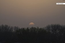
86
IMG 2356 copy
Sunset over trees at the west end of the Grand Valley near Grand Junction, Colorado on the evening of April 20, 2008
| 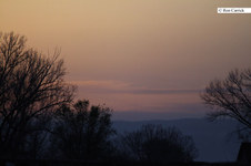
87
IMG 2375.copy
Another look at the Grand Valley western end sunset same day.
| 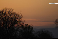
88
IMG 2380.copy
Another exposure of the same area and day
|
89
106 0676 RT8Xcopy
I think this was in 2004. The location is just east of Lewistown, Montana on the divide.
| 
90
137 3728 RJ up copy
same old barn and house near Kendal April 9, 2004
| 
91
139 3915 RJ copy
This one has been about to fall over for several years.... near the other old abandoned farms on the same gravel road. Taken April 18, 2004
| 
92
145 4504 RJ.copy
Ranch buildings in the hills of on Bever Creek road....near Lewistown, Montana.
|
93
152 5212 RJXcopy
Old barn with a tree that has grown through the roof on High way 12 between Walla Walla, WA and Lewiston, Idaho. May 20, 2004
| 
94
182 8280 RJ.copy
Old barn between Hobson and Utica west of Lewistwon,MT
| 
95
226 2679 RJ copy
Sign on a stained shed in Lewistown of my next door neighbors.
| 
96
250 5079 RJ copy
This picture was taken on April 2, 2006. This was located on the road to the Grand Mesa, on the right just before the Collbran turn off.
|
97
5D 0953 copy
More of the cute hay barn on June 16, 2006
| 
98
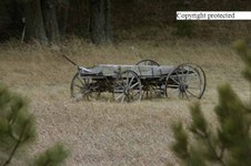
205 0552 RJ UPXcopy
Old wagon in a back yard of a summer home on Maiden Canyon Road close to Maiden, MT an old abandoned Mining town and 20+ miles from Lewistown, MT. on December 7, 2004
| 
99
IMG 6996 copy
This Old roof less log house is a mile or two farther south than the next photo. This photo was taken Aug. 30, 2007 in Glade Park above Colorado National Monument. Taken August 30, 2007
| 
100
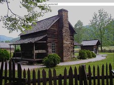
P5181033.JPGX-XSmokeyXMtnXCabinXcopy
May 18, 2000 This old cabin is at the East entrance of Smokey Mountain National Park I am quite sure of. I went through there in May of 2000 with my Dad.
|
101
P9100089 copy
Old Log miners cabin off Yogo Canyon in the Belt Mountains of Central Montana. Taken in 2002
| 
102
PB050002 copy
Old barn on Bever Creek west of Lewistown, MT taken 2000
| 
103
PB300003 copy
| 
104
5D 3776 copy
Old weathered shack at Abondoned mining town of Maiden, Montana town site. Summer time July 7, 2006
|
105
149 4983 RJ copy
Coast Guard boat anchored off shore. Taken May 16, 2004
| 
106
151 5137 RJXcopy
Looking up the Columbia River near Crown Point Look out. May 19, 2004
| 
107
149 4972 RJ copy
Coming closer to the light house north of New Port Oregon. May 16, 2004
| 
108
150 5049 RJ copy
......just off Oceanside, OR May 16, 2004
|
109
115 1552 RT8 copy
Castle Creek... S.E of Lewistown 10 miles or so ... it was snowing. October 30, 2003
| 
110
IMG 2747
Left center is Independent Monument in the fog..... Tuesday the 24th of February 2009 at straight up 9 am. It was so foggy over Fruita and most of the Valley.
| 
111
IMG 2761
Not much movement now... taken 2009_02_24
| 
112
IMG 2762
included the bushes in the for ground too.
|
113
IMG 2764
I noticed several vehicles parked along the road... I was sure it had to be people with cameras. Sure enough when I got to the area there, there were several people with cameras taking photo's of this...
| 
114
IMG 2776
regular lens on the 5D
| 
115
IMG 8102 copy
This formation looks like the swirl top of a chocolate ice cream cone. It is rock though.
| |
