1
0
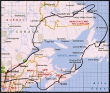
Route of Expedition
| 
2
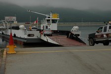
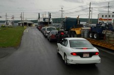
DSC 0234
July 6 2005
Ferry across Lake Champlain, NY
The boats turn to ships real soon
| 
3
1
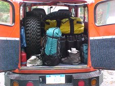
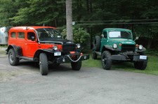
Total inspection, Hardening the nose and loading GPS way points
|

4
2
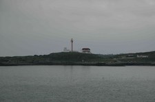
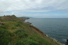
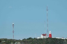
| 
5
3
| 
6
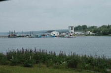
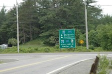
4
|

7
5
| 
8
6
Loaded, ready to roll
| 
9
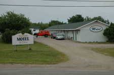
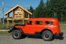
DSC 0248
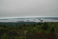
Top of Cadillac Mountain, Acadia
National Park, Bar Harbor, Maine
|
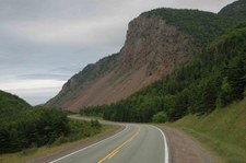
10
DSC 0249
| 
11
DSC 0251
| 
12
DSC 0254
|

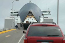
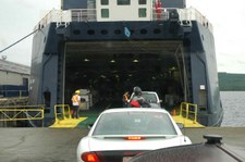
13
DSC 0256
Line up to board Cat Ferry
| 
14
DSC 0259
| 
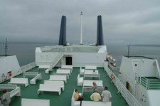
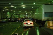
15
DSC 0269
Inside Cat Ferry car/truck deck
|
16
DSC 0290
Cape Forchu Lighthouse, Yarmouth, Nova Scotia
| 
17
DSC 0307
East Baccaro, Nova Scotia
| 
18
DSC 0311
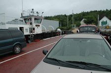
|

19
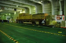
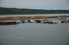
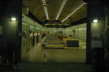
DSC 0312
| 
20
DSC 0314
| 
21
DSC 0317
Liverpool, NS
|

22
DSC 0318
| 
23
DSC 0321
| 
24
DSC 0322
|

25
DSC 0323
| 
26
DSC 0326
| 
27
DSC 0331
Visit to cdnBRUCEcdn in Bridgewater, NS
Thanks Bruce for the GREAT route to bypass Halifax
|

28
DSC 0333
cdnBRUCEcdn 1957 Power Wagon
| 
29
DSC 0338
Trans Canada Highway 102 heading for Truro, NS Running 60 mph
| 
30
DSC 0339
Canso Causeway to Cape Breton
Nova Scotia
|
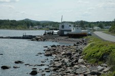
31
DSC 0340
Motel at Inverness, NS
That evening all the local kids and their trucks showed up to check out the Carryall.
| 
32
DSC 0343
Inverness, NS
| 
33
DSC 0345
|

34
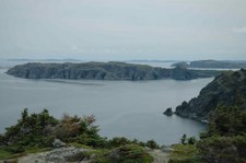
DSC 0346
| 
35
DSC 0351
Heading North up Cape Breton Island
| 
36
DSC 0354
|

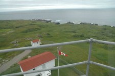
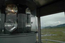
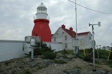
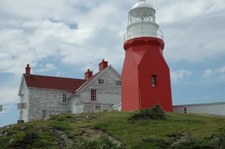
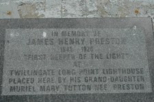
37
DSC 0359
The next series of pictures are all within the Park
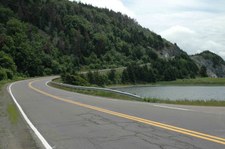
| 
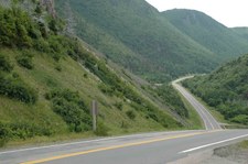
38
DSC 0361
| 
39
DSC 0362
|
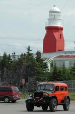
40
DSC 0363
| 
41
DSC 0364
| 
42
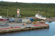
DSC 0365
|
43
DSC 0368
| 
44
DSC 0369
| 
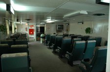
45
DSC 0370
|
46
DSC 0373
| 
47
DSC 0375
| 
48
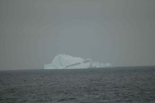
DSC 0377
|

49
DSC 0383
| 
50
DSC 0384
| 
51
DSC 0386
|
52
DSC 0388
| 
53
DSC 0401
Whale Watching at Pleasant Bay, NS
| 
54
DSC 0446
|

55
DSC 0495
| 
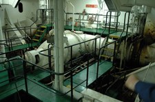
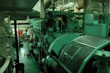
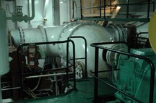
56
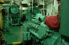
DSC 0530
Cape North, NS
Really Great Food and right across from Motel
| 
57
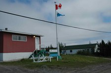
DSC 0531
Motel, Cape North, NS
Again tonight, many people stopped at the motel to look at the Carryall. Its hared to miss from the road
|
58
DSC 0532
| 
59
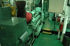
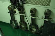
DSC 0536
| 
60
DSC 0537
Heading south towards North Sydney, NS
|

61
DSC 0538
| 
62
DSC 0539
| 
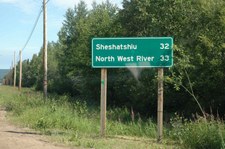
63
DSC 0540
|
64
DSC 0546
| 
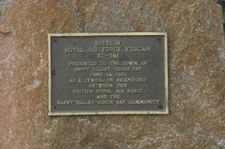
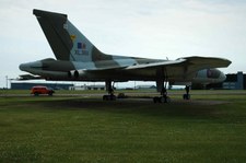
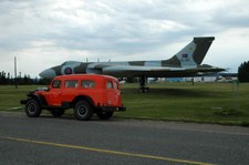
65
DSC 0548
Englishtown, NS
Another cable ferry. Short 5 minute ride that saves tons of miles
| 
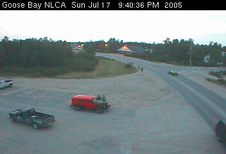
66
DSC 0549
|

67
DSC 0555
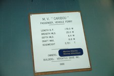
NOrth Sydney, NS
Marine Atlantic Terminal. The ship is the MV Caribou which we will take north for 6 hours to Channel-Port aux Basques, Newfoundland. Note trailers loading top and bottom decks.
| 
68
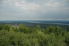
DSC 0558
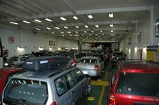
We are in the boarding lanes. Before we boarded, the entire lot was full of cars and trucks.
| 
69
DSC 0565
|

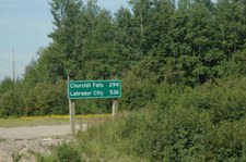
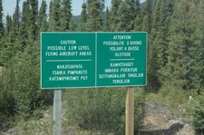
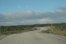
70
DSC 0576
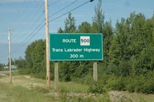
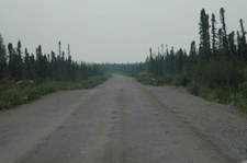
| 
71
DSC 0582
| 
72
DSC 0583
|

73
DSC 0600
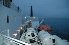
Rain and Fog = Fog Horn every 2 minutes. After a while you get used to the fog horn and dont hear it.
| 
74
DSC 0604
| 
75
DSC 0605
|

76
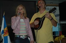
DSC 0607
Bugs Green and Debbie, Newfoundland. Newfie music is something like Bluegrass and country. You should hear him on the fiddle doing the Orange Blossom Special. Bought a few CD's for the ride.
| 
77
DSC 0608
| 
78
DSC 0609
|

79
DSC 0615
| 
80
DSC 0616
MV Caribou Chief Steward playing the Spoons.
| 
81
DSC 0617
|

82
DSC 0618
Sunset from the MV Caribou. It will be after 10m pm Newfoundland time when we arrive in Channel-Port aux Basques, Newfoundland
| 
83
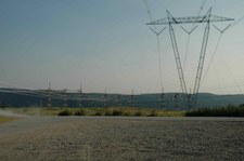
DSC 0620
| 
84
DSC 0623
|

85
DSC 0631
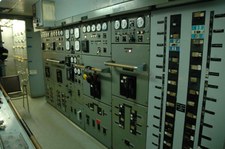
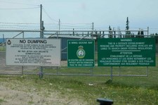
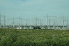
Channel- Port aux Basques, Newfoundland. Today the crossing took 6 hours. A crew member told me during the winter with Ice and heavy seas he has seen the crossing take 15 hours.
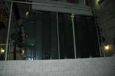
| 
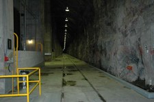
86
DSC 0632
Ready to unload
| 
87
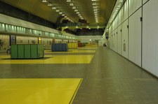
DSC 0633
|

88
DSC 0635
I never saw this beautiful Plymouth load. I believe its a 1959 ???
| 
89
DSC 0642
Snow Plow on the old Channel-Port Aux Basques to St. John's Train
| 
90
DSC 0644
|

91
DSC 0650
Now that the TCH connects the Island of Newfoundland the train is no longer in service. However the road bed is a atv and snbowmobil trail for the entire distance of almost 900 km.
| 
92
DSC 0651
Controls for the Snowplow
| 
93
DSC 0652
Picture of this Plow fighting snow on the tracks
|
94
DSC 0654
| 
95
DSC 0657
| 
96
DSC 0658
|
97
DSC 0659
| 
98
DSC 0660
| 
99
DSC 0662
|
100
DSC 0666
| 
101
DSC 0668
| 
102
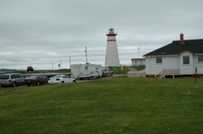
DSC 0670
Cape Ray Lighthouse
|
103
DSC 0671
| 
104
DSC 0673
| 
105
DSC 0674
TCH headiung north towards Stephenville, NL
|

106
DSC 0677
| 
107
DSC 0678
| 
108
DSC 0684
|
109
DSC 0685
Little Burnt Bay, NL
| 
110
DSC 0686
| 
111
DSC 0687
|

112
DSC 0689
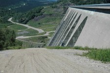
| 
113
DSC 0690
Clioff is a great guy. I stopped at his little park, he came out to look at the Carryall. he built his home and gardens and park. He was born on Exploits Island. CLiff invited me in for some pie. We had a nice visit and I left some PW Maple with him.
| 
114
DSC 0691
|

115
DSC 0692
Original Fish Scale
| 
116
DSC 0695
| 
117
DSC 0696
|
118
DSC 0697
| 
119
DSC 0702
| 
120
DSC 0703
|

121
DSC 0705
High School was having a car wash and The Carryall really needed a Bath
| 
122
DSC 0709
The following pictures are all from north Twillingate Island, NL
| 
123
DSC 0713
|

124
DSC 0715
| 
125
DSC 0724
| 
126
DSC 0725
|

127
DSC 0726
| 
128
DSC 0727
| 
129
DSC 0728
|

130
DSC 0730
| 
131
DSC 0736
Long Point Lighthouse, North Twillingate Island, NL
| 
132
DSC 0737
|

133
DSC 0738
| 
134
DSC 0748
| 
135
DSC 0755
|

136
DSC 0766
| 
137
DSC 0782
| 
138
DSC 0783
|
139
DSC 0785
| 
140
DSC 0789
| 
141
DSC 0794
Long Point Lighthouse /Carryall
|
142
DSC 0799
| 
143
DSC 0800
| 
144
DSC 0806
|
145
DSC 0808
| 
146
DSC 0809
| 
147
DSC 0817
|

148
DSC 0832
MV Sir Robert Bond will be our home for the next 43 hours up Ice Berg Alley to Goose Bay, Labrador
| 
149
DSC 0836
Time to Load. This is the point of no return. From here you are committed to the 539 Miles of Gravel that lay ahead. Carryall is running as expected, green light, load her in.
| 
150
DSC 0838
|
151
DSC 0845
| 
152
DSC 0849
| 
153
DSC 0850
|

154
DSC 0851
| 
155
DSC 0852
| 
156
DSC 0855
Seating on the MV Bond. Some people elect to sit in one of these seats for 43 hours. I got a nice cabin. After 43 hours the people in these seats have a blank stare and are drooling
|

157
DSC 0857
| 
158
DSC 0859
| 
159
DSC 0864
|

160
DSC 0867
My Cabin on the MV Sir Robert Bond
| 
161
DSC 0868
| 
162
DSC 0869
|

163
DSC 0871
| 
164
DSC 0872
| 
165
DSC 0877
|
166
DSC 0888
Some of the Ice Bergs coming down Ice Breg Alley
| 
167
DSC 0889
| 
168
DSC 0891
|

169
DSC 0898
| 
170
DSC 0926
Cartwright, Labrador.
The Logs will be loaded on ocean going barges and towed south for 8 days. They will end up at Grand Falls/Windsor for processing.
| 
171
DSC 0933
|

172
DSC 0936
The next series are from Cartwright, Labrador. We were in port while cargo was unloaded. Then back to sea, finally into the Hamilton Inlet and Lake Melville to Goose Bay/Happy Valley Labrador
| 
173
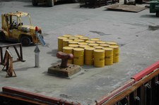
DSC 0937
Wonder what is in those salvage overpack drums ?????maybe I dont want to know
| 
174
DSC 0941
|

175
DSC 0943
| 
176
DSC 0944
| 
177
DSC 0945
|

178
DSC 0946
| 
179
DSC 0947
| 
180
DSC 0949
|

181
DSC 0950
| 
182
DSC 0956
| 
183
DSC 0957
Cartwright, Fire Dept
|

184
DSC 0960
| 
185
DSC 0961
| 
186
DSC 0964
|

187
DSC 0969
| 
188
DSC 0971
While in Cartwright, the Chief Engineer came by and wanted to see the Carryall. We went down on the cargo deck and I gave him the Nickle tour. Then I looked at him and said ITS YOUR TRUN....I want to see the engine room and everything below decks. He said follow me.
| 
189
DSC 0972
|
190
DSC 0973
| 
191
DSC 0974
The MV Bond is Twin Screw. There are two 2200 hp diesels on each prop, driving thru a reduction gear box providing a constant prop shaft speed of 200 RPM's. Speed and direction is controlled by prop pitch
| 
192
DSC 0976
|
193
DSC 0977
CO2 fire protection systems
| 
194
DSC 0978
| 
195
DSC 0979
Stern Thruster
|

196
DSC 0980
Prop Shaft
| 
197
DSC 0981
| 
198
DSC 0982
|

199
DSC 0983
| 
200
DSC 0984
| 
201
DSC 0985
|
202
DSC 0986
Bow Thruster
| 
203
DSC 0987
Air Operated valve on bow Thruster
| 
204
DSC 0988
Spare Connecting Rods for engines.
|
205
DSC 1044
| 
206
DSC 1045
| 
207
DSC 1046
|

208
DSC 1048
| 
209
DSC 1051
| 
210
DSC 1053
|

211
DSC 1064
If you dont get a cabin, some people opt to sleep on the floor. Must be a hard trip
| 
212
DSC 1077
Arriving at Goose Bay, line handlers coming out to meet ship
| 
213
DSC 1079
Landing at Goose Bay/Happy Valley Labrador
|
214
DSC 1082
| 
215
DSC 1083
I pulled over to get a picture and before I was done people started to stop and ask questions. I was here for over an hour
| 
216
DSC 1087
Heading to North West River. The end of all roads in this part of North America. They say to drive further north, one must go to Alberta, Canada
|

217
DSC 1098
This is it !!! The end of all roads
| 
218
DSC 1099
| 
219
DSC 1101
This is the former USAF SAC Base at Goose Bay, Labrador
|
220
DSC 1102
| 
221
DSC 1104
| 
222
DSC 1105
RAF Vulcan Bomber
|
223
DSC 1106
| 
224
DSC 1107
| 
225
DSC 1108
|
226
DSC 1109
| 
227
DSC 1110
Live Newfoundland/Labrador Highway Camera, Goose Bay/Happy Valley Labrador
| 
228
DSC 1111
|

229
DSC 1112
| 
230
DSC 1005
| 
231
DSC 1113
|

232
DSC 1114
| 
233
DSC 1115
| 
234
DSC 1116
|

235
DSC 1117
| 
236
DSC 1130
View from mountain top of Former USAF Sac Base, Now 5 Wing Goose Bay
| 
237
DSC 1133
Chruchill River. The water you see has gone thru the Hydro Power Project at Chruchill Falls
|

238
DSC 1143
Best Motel on trip. Simply beautiful at Goose Bay
| 
239
DSC 1144
| 
240
DSC 1145
Here we are, the purpose for this trip
|
241
DSC 1146
| 
242
DSC 1147
Belive the sign, there is nothing ahead but you and the gravel for a long time
| 
243
DSC 1148
|
244
DSC 1149
This next series of pictures are from Goose Bay to Churchill Falls, Labrador
| 
245
DSC 1151
East / West Hammer Lane on the Trans Labrador Highway.
| 
246
DSC 1152
|

247
DSC 1153
| 
248
DSC 1155
| 
249
DSC 1156
|
250
DSC 1158
| 
251
DSC 1159
| 
252
DSC 1163
|

253
DSC 1165
When a truck passes, stop, close the window, your in for a white out of dust.
| 
254
DSC 1167
| 
255
DSC 1172
|

256
DSC 1173
| 
257
DSC 1177
| 
258
DSC 1183
|
259
DSC 1185
| 
260
DSC 1187
| 
261
DSC 1188
|

262
DSC 1189
| 
263
DSC 1191
The original Highway went up that hill. Many hills and curves have been rebuilt or moved
| 
264
DSC 1192
|

265
DSC 1197
| 
266
DSC 1198
| 
267
DSC 1200
|

268
DSC 1201
| 
269
DSC 1202
| 
270
DSC 1204
|
271
DSC 1205
| 
272
DSC 1206
| 
273
DSC 1207
The road gets worse, better, worse and better. Its a road of constantly changing conditions
|

274
DSC 1208
| 
275
DSC 1209
| 
276
DSC 1211
|

277
DSC 1212
| 
278
DSC 1213
| 
279
DSC 1215
Osprey Nest
|

280
DSC 1216
Here comes my friend, the Grader. Smooth road for a while. Keep off the wind rows where he grades. Stones as large as concrete blocks lurk in the wind rows. Eventually they will be graded off the road
| 
281
DSC 1217
| 
282
DSC 1220
|
283
DSC 1222
| 
284
DSC 1223
| 
285
DSC 1226
Caribou are shot and quartered right along roads
|

286
DSC 1231
The sign red numberf showing Mega Watt output did not come out well. AT the time of this picture, the Site was supplying 3513 Mega Watts. During the winter, the output is 5500 Mega Watts.
| 
287
DSC 1234
| 
288
DSC 1235
Churchill Falls is a company town with about 200 people. All homes are only on one side of each street to make room for blowing snow
|

289
DSC 1237
Engine Heater plug'in everywhere
| 
290
DSC 1238
| 
291
DSC 1240
|
292
DSC 1241
| 
293
DSC 1242
Security, Fire Station and Main Control Room
| 
294
DSC 1243
11 Penstocks are 40 feet below the water and drop 1000 feet the the turbines
|
295
DSC 1249
Main transformer room for the 11 transformers. You are now 1000 feet underground
| 
296
DSC 1251
| 
297
DSC 1252
|

298
DSC 1256
Pipes are drilled into the walls to measure if any water is seeping in behind the rock
| 
299
DSC 1260
| 
300
DSC 1265
These cars are always here, key in and run each shift. They are the emergency escape. Its about 2km till they reach the outside thru the tunnel system
|

301
DSC 1269
| 
302
DSC 1271
Refuge behind these doors. Fire/Smoke/water tight. Inside is food, water for 60 people for a month. Fresh air to the outside and diesel emergency power
| 
303
DSC 1272
|

304
DSC 1273
| 
305
DSC 1278
| 
306
DSC 1280
|

307
DSC 1284
| 
308
DSC 1286
| 
309
DSC 1287
Your at 1000 feet underground. This is the largest Under Ground Hydro Plant in the World.
|

310
DSC 1289
| 
311
DSC 1290
| 
312
DSC 1291
|

313
DSC 1296
This device marries the two huge over head cranes so they can lift the 600 ton rotors in the generators . One is shown on the next page with the tour guide
| 
314
DSC 1297
| 
315
DSC 1300
This is the turn to the Esker Railroad station. I went in about 50 miles, more on Esker In the Trip Log
|

316
DSC 1302
Following few pictures are on the Esker Road
| 
317
DSC 1305
| 
318
DSC 1307
|

319
DSC 1309
| 
320
DSC 1319
| 
321
DSC 1325
|

322
DSC 1330
| 
323
DSC 1332
Back on the Trans Labrador Highway heading to Labrador City
| 
324
DSC 1333
|

325
DSC 1334
| 
326
DSC 1336
| 
327
DSC 1339
|

328
DSC 1343
| 
329
DSC 1345
| 
330
DSC 1349
|

331
DSC 1350
Cindy II an old Bombardier was sitting by the railroad tracks on the Trans Lab Highway. Its like a trun back in time, both rigs are old. I would love to have brought her home with me. When I got to Labrador City, I found the owner
uses it all the time in the winter.
| 
332
DSC 1351
| 
333
DSC 1352
|

334
DSC 1353
| 
335
DSC 1358
TAR, TAR, TAR WOW, coming into Labrador City.
| 
336
DSC 1359
Leaving Labrador at km 0. At the Quebec Border. Now the road will get really bad in places
|
337
DSC 1360
Into Quebec, the Tar only lasts for about 15 miles.
| 
338
DSC 1362
This sign is CRITICLE !!! If any of the lights are on, the road is closed between those points. There is no bypass or other road. STop turn back.
| 
339
DSC 1363
I am now on the road at Mount Wrght Iron Mine. The road base is mine tailings, ungraded, pot holes, worse than worse.
|

340
DSC 1365
Fermont is the last little town before going back into the bush
| 
341
DSC 1366
Yor now on Quebec Rt 389 and will be on it for many a long hour. 11 hours from Labrador City to Baie-Comeau Quebec
| 
342
DSC 1367
|
343
DSC 1368
| 
344
DSC 1369
| 
345
DSC 1375
|

346
DSC 1379
| 
347
DSC 1380
| 
348
DSC 1394
|
349
DSC 1395
Towers at the closed Fire Lake Iron Mine
| 
350
DSC 1397
Back on Tar as we approach the Ghost Twon of Gagnon
| 
351
DSC 1402
Note the driveway cuts wherre the homes once stood
|

352
DSC 1407
| 
353
DSC 1408
| 
354
DSC 1413
You will see this a few times on Rt 389. Your on Tar,and road goes back to Gravel
|
355
DSC 1415
| 
356
DSC 1419
The old road heading up the hill
| 
357
DSC 1420
|
358
DSC 1424
| 
359
DSC 1427
| 
360
DSC 1428
|

361
DSC 1429
| 
362
DSC 1430
| 
363
DSC 1433
|

364
DSC 1434
| 
365
DSC 1435
| 
366
DSC 1436
|

367
DSC 1443
| 
368
DSC 1444
Hard to figure, no house, no road, no path, just a mail box ?
| 
369
DSC 1446
|
370
DSC 1450
| 
371
DSC 1452
| 
372
DSC 1460
Relais Gabreil comming into view
51.19.34 LAT
068.07.21 lONG
The only fuel on this bush road
|

373
DSC 1461
The Motel unit in the rear is available
| 
374
DSC 1462
These overnight Cottages are also available.
| 
375
DSC 1463
Diesel 1.19 Per Liter. I filled up, as I wanted to keep my Jerry cans for an emergency
|

376
DSC 1465
I hope its not a real SOS. That phone is 97 km away.
| 
377
DSC 1470
| 
378
DSC 1476
|

379
DSC 1483
| 
380
DSC 1484
No Moose, No Bear, No Caribou, just a lone Porky. I think he spoke French, I called at him to turn around for the picture, he just kept going. Oh Well
| 
381
DSC 1486
|

382
DSC 1487
Top of Manic 5 Hydro Project
| 
383
DSC 1488
| 
384
DSC 1489
Check the 18% grade, with twists and switchbacks
|
385
DSC 1491
| 
386
DSC 1493
| 
387
DSC 1494
|

388
DSC 1499
| 
389
DSC 1500
| 
390
DSC 1501
Manic 5 and water from Space Shuttle
|

391
DSC 1502
This is it, back on TAR. At Manic 5, TAR starts all the way to Baie-Comeau
| 
392
DSC 1504
Ferry at Tadoussac Quebec, crossing the Saguenay Fijord. Very Beautiful Area
| 
393
DSC 1505
|

394
DSC 1506
| 
395
DSC 1507
I think the Big Guy coppied my Color
| 
396
DSC 1508
Crossed the St Lawrence River at St Simeon / Riviere du loup, Quebec
|
397
DSC 1514
Line up for Ferry
| 
398
DSC 1516
| 
399
DSC 1526
|

400
DSC 1539
Running on Auto Route 20 in Quebec, heading home. Running 60 mph and they were blowing my doors off passing me
| 
401
DSC 1540
Almost home, I will be in my own bed tonight. After 18 days on the road, it will good to get home
| 
402
DSC 1542
I got the T Shirt
|

403
DSC 1543
Sweetheart got the Badge
| 
404
DSC 1550
Scanned picture of Western Brook Pond, Gros Morne National Park in Newfoundland. I will return with my M-37 Bandit. Its a 2 day hike into this point
| 
405
R01
|

406
R02
| 
407
R03
| 
408
R04
|

409
R05
| 
410
R06
| 
411
R07
|

412
R08
| 
413
R09
| 
414
R10
|

415
R11
| 
416
R12
| 
417
to-rebuild
Follow the link in the picture to visit the complete reconstruction.
From a Rusty Bucket of Bolts to Sweetheart
|