
1
The Stirling Range through the Windscreen
The Stirling Range National Park was included in the National Heritage List on 15 December 2006.
| 
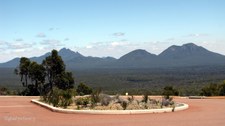
2
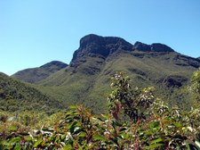
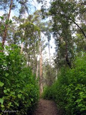
View from Bluff Knoll Carpark
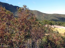
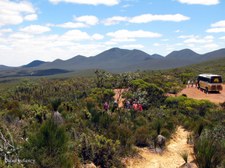
Formed over millions of years by weathering and erosion, the Stirling Range in south-west Western Australia is regarded as an area of great biogeographic and evolutionary interest and displays one of the richest floras in the world. The Stirling Range is a popular destination for its mountain views, wildflowers, bird and animal life.
| 
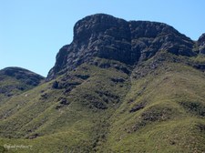
3
Bluff Knoll zoomed from Carpark
The Nyoongar people of the area referred to Bluff Knoll as Bular Mial (many eyes) or Bala Mial (his eyes), as they believed the rocks on the bluff were shaped like the eyes of an ancestral master spirit that are visible on the mountain.
|

4
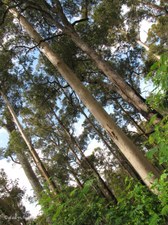
Viewing Platform at Bluff Knoll
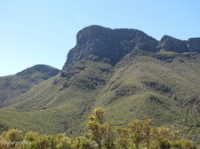
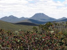
The range stretches for 65 kilometres from east to west and the tallest peak Bluff Knoll stands at 1059 metres above sea level.
| 
5
Stirling Range Panorama
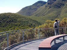
Stitched from the following five images.
| 
6
Panorama 1
|

7
Panorama 2
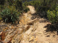
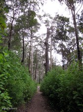
| 
8
Panorama 3
| 
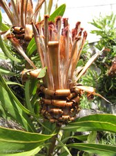
9
Panorama 4
|

10
Panorama 5
| 
11
The Stirling Range has many Peaks
| 
12
Bluff Knoll Carpark
|

13
Road Maintenance Crew Painting the White Lines
| 
14
The Stirling Range
Aboriginal Heritage -- The Mineng and Goreng people are believed to have originally lived in and around the mountains. Many Creation stories reflect the mystery and danger of the jagged peaks of the Stirling Range, particularly Bluff Knoll.
| 
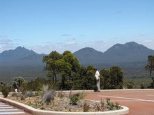
15
The distinctive Bluff Knoll Peak
Located in the Stirling Range National Park, Bluff Knoll is the highest and one of the most spectacular peaks in the south of Western Australia.
|

16
Other Peaks beside Bluff Knoll
| 
17
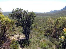
Hills and Valleys
| 
18
Views to Admire from Eastern Lookout
|

19
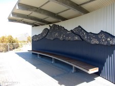
A Range of Biodiversity
Outline of the Stirling Range with images of some of its flora and fauna. This image forms a mural in the shelter facing Bluff Knoll.
| 
20
Mural in Information Shelter
Information shelters in the park provide information about the plant and animal life in the area and guide you to sites of interest.
| 
21
Mural -- section 1
|

22
Mural -- section 2
| 
23
Mural -- section 3
| 
24
Mural -- section 4
|

25
Walking Trail
Listed as one of Australia's 25 best hikes, Bluff Knoll provides an admirable and rewarding challenge for bushwalkers, rock climbers and abseilers of all levels.
| 
26
Trail to Bluff Knoll from Eastern Lookout
Bluff Knoll is one of the few places in the state to actually experience occasional snow fall.
| 
27
Entering the Bluff Knoll trail
This Top Trail commences from the car park, along a well formed and maintained path. The weather can often surprise you: no matter how hot you feel in the car park before beginning the climb, take a sweater with you. The weather can change quickly on the summit.
|

28
Stirling Range Vegetation
| 
29
Kingia australis
A perennial tree-like monocot which grows 1–8 m high.
| 
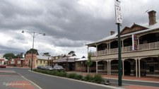
30
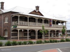
Flowerheads of Kingia australis
The Kingia australia has drum-stick like flowerheads which distinguish it from the Grasstree which has long spear-like flowerheads.
|

31
Agonis species
| 
32
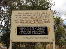
Fountain Triggerplant (Stylidium)
| 
33
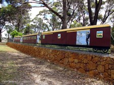
Mountain View
|

34
Northern end of the Stirling Range
| 
35
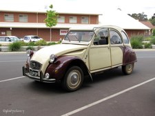
Walking Trail to Bluff Knoll
| 
36
Stirling Range Scenery
|

37
Kingia australis standing tall
| 
38
Southern Cross
Xanthosia rotundifolia
| 
39
These energetic Hikers hoped to reach the top
Time for me to return.
|

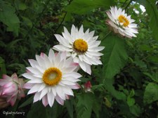
40
Bluff Knoll from Walking Trail
| 
41
Stirling Range Landscape
| 
42
Upright buds of Euculuptus species
|

43
Eucalypts beside the path
| 
44
Faded flower of Dryandra
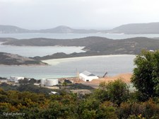
| 
45
Coloured Rocks on the Hillside
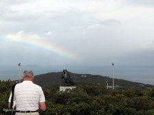
|

46
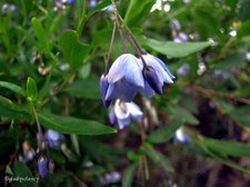
Kingia australis with a Mountain View
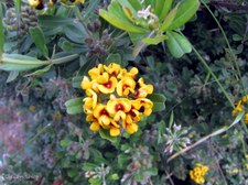
Kingia australis is endemic in south-western Australia, it has drumstick flower heads and develops a thick, fibrous trunk surrounded by persistent leaf bases trhough which the roots pass from the crown to the soil. It grows to 8m tall, occasionally in small clumps.
| 
47
Dried flowerheads of Kingia australis
| 
48
Bluff Knoll from Information Shelter
|

49
Return to Information Shelter
| 
50
Outline of Stirling Ranges in Mural
| 
51
Eco-Toilet with a View
|

52
The Folds of the Landscape
| 
53
Farmland in the Distance
| 
54
Diversity of Vegetation
|
55
Stirling Range Vegetation
| 
56
Stirling Range from Carpark
| 
57
Hills and Valleys
|

58
Agricultural Land in the Distance
| 
59
Bluff Knoll towers above
| 
60
One of the many Peaks in the Stirling Ranges
|

61
Colourful Artwork of Wicked Campers
| 
62
Stirling Range in Wideview
| 
63
View towards Agricultural Areas
|

64
Stirling Range from Carpark
| 
65
One last shot of the Stirling Range
| 
66
Time to move on again
|

67
Walking up to the Western Lookout
Another section of the Stirling Ranges along Stirling Range Road.
| 
68
Stirling Range Road winds between the Hills
This is the road we have just travelled along.
| 
69
Still climbing up the path
|

70
The View from the Top
Looking in a southerly direction from the Western Lookout.
| 
71
Mountain Views
| 
72
Zoomed in to the Mountains
Stirling Range National Park.
|

73
Clouds cast Shadows over the Land
| 
74
Melaleuca species
| 
75
Purple Wildflower
Leaves are very prickly.
|

76
Scenic View
| 
77
Landscape
| 
78
Adjacent Hilltop
|
79
Eucalyptus species
| 
80
Stirling Range National Park
| 
81
Vegetation of the Stirling Ranges
|

82
Yellow Starflower (Calytrix sp.)
| 
83
Returning down the pathway
| 
84
The winding path
|

85
Undulating Landscape
| 
86
Rocky Terrain
| 
87
Colours in the Rocks
|

88
Our Bus is waiting
Stirling Range Road travels 42 kms through the heart of the national park and offers scenic views when travelled in either direction.
| 
89
Flowerheads on Male Sheoak
Casuarinaceae species.
| 
90
Seed Capsules on Female Sheoak
Casuarinaceae species.
|

91
Stirling Range View 1
| 
92
Stirling Range View 2
| 
93
Stirling Range View 3
|

94
Plantagenet Wines at Mt Barker
| 
95
Plantagenet Wines Cellar Sales
| 
96
Bottlebrush flower
|

97
Shire of Plantagenet Council Chambers
Mt Barker.
| 
98
Mt Barker Visitor Centre
Formerly Mt Barker Railway Station.
| 
99
Modern Toilet Block featuring the Corrugated Iron Look
|

100
Mt Barker street scape
| 
101
Plantagenet Hotel
| 
102
Warrie Products
|

103
Window Display
Illustrating a Sheep Shearer using the Warrie Back-Aid.
| 
104
Warrie Back-Aid for Shear Relief
| 
105
Main Street of Mt Barker
|

106
Bees gathering Nectar from Flowering Gum
Eucalyptus species.
| 
107
Red Bottlebrush (Callistemon)
| 
108
Railway Mural at Mt Barker
This mural depicts a 1920's passenger train taking on water at the Guvvy (Government) Dam.
|

109
Train Mural
The Train was an integral part of the development of this region.
| 
110
Information
| 
111
WAGR Steam Engine
|

112
First Class Carriage
| 
113
Second Class Carriage
| 
114
The Guard's Van at the rear
|

115
Pin-Board made of Goundrey Wine Corks
| 
116
Protea Flowers in a local Garden
| 
117
Classic Citroen in Mt Barker
Appears to be a Citroen 2CV 'Dolly', 1986 model in Plum & Custard Decor.
|

118
Entering the Porongurup Ranges
The unique Porongurup Range is a 15 minute drive east of Mt Barker.
More than 1100 million years have passed since the formation of this distinctive landform. As the climate changed and the forests retracted, the deep red soils, high rainfall and towering granite peaks became host to the majestic karri trees, with their understorey of flowers and shrubs.
| 
119
Porongurup Ranges
Rising abruptly from the surrounding farmland, this spectacular forest is rich in rugged beauty, unique plant life and abundant fauna. Birdwatchers and photographers revel in the 78 species of birdlife, from majestic Wedge tailed eagles to small scarlet robins and the electric blue plumage of the splendid fairy wrens.
| 
120
Karri Trees and Understorey
Whilst most animals, such as possums, bandicoots and antechinuses are nocturnal, western grey kangaroos and brushtail wallabies can be seen amongst the lush undergrowth that provides a home for monitor lizards, skinks and racehorse goannas.
|

121
Karri Trees tower overhead
There are many walk trails to lead you into this fascinating, diverse habitat.
| 
122
Tree in the Rock
A tall Karri Tree grows out of a crack in the granite rock.
| 
123
Tree in the Rock
A tall Karri Tree grows out of a crack in the granite rock.
|

124
Lichen on a Branch
| 
125
Karri Trees straight and tall
| 
126
At Ground Level
Granite Rocks covered with moss and lichen, and dainty wildflowers.
|

127
Looking Upwards at Porongurups
| 
128
Lush Green Understorey
| 
129
Bracken Fern
Pteridium esculentum.
|
130
Clean Straight Trunks of the Karri Trees
| 
131
Creamy Candles
Stackhousia monogyna.
| 
132
Decay of a large Tree Stump
|
133
Everlastings
| 
134
Everlastings
| 
135
Everlastings
|
136
Walking Trail, Porongurup Ranges
| 
137
Albany Panorama in Misty Rain
Taken from Desert Mounted Corps Memorial on Mt Clarence.
| 
138
The Gallipoli Pine on Mt Clarence, Albany
|

139
Gallipoli Pine Planted 2nd Nov 1974
Commemorating the Diamond Jubilee of the first Australian troopships to leave Albany to take troops to the Great War in 1914.
| 
140
Desert Mounted Corps Memorial
Mt Clarence, Albany.
| 
141
Desert Mounted Corps Memorial
Unveiled in 1968, this memorial consists of a free-standing cast bronze figure of two troopers and their horses set on a granite base.
|

142
Desert Mounted Corps Memorial
It depicts a mounted Australian Light Horseman defending a New Zealander who stands besides his wounded horse.
| 
143
Plaque at Base
This Statue is a copy of one originally forming part of a Memorial which was erected at Port Said and unveiled on 23 November 1932 by the Rt Hon William Morris Hughes, KC, MP. It was irreparably damaged during the Suez Crisis in 1956. The masonry was salvaged and brought to Australia for re-erection on this site which, for many troops who sailed from King George Sound in 1914, was their last glimpse of Australian soil.
| 
144
Inscription on Wall
Erected by their comrades & the Governments of Australia & New Zealand in memory of the members of the Australian Light Horse, the New Zealand Mounted Rifles, the Imperial Camel Corps & the Australian Flying Corps who lost their lives in Egypt, Palestine & Syria. 1916 - 1918.
|

145
King George Sound from top of Mt Clarence
| 
146
Zoomed to Desert Mounted Corps Memorial
| 
147
King George Sound and Princess Royal Harbour
Woodchip export facility in foreground, and Whale World in the far distance.
|

148
Grain Silos and Princess Royal Harbour
| 
149
Princess Royal Harbour
New Entertainment Centre under construction, also Peace Park.
| 
150
A Rainbow in the Sky
I wasn't the only one who thought it worth a photo!
|

151
Fading Rainbow over Desert Mounted Corps Memorial
| 
152
Australian Bluebell
Sollya heterophylla.
| 
153
Silky Yellow Pea
Nemcia retusa on top of Mt Clarence.
|

154
Brass Plaque on top of Mt Clarence
Indicating points of interest which can be viewed from here.
| |
