Buckskin Ridge/Cascade Crest Trail
Day 1: Slate Pass to Silver Lake
Day 2: Silver Lake to Buckskin Lake
Day 3: Buckskin Lake Wild Goose Chase
Day 4: Buckskin Lake to Coney Basin
Day 5: Coney Basin to Goat Lake
Day 6: Goat Lake to Trailhead
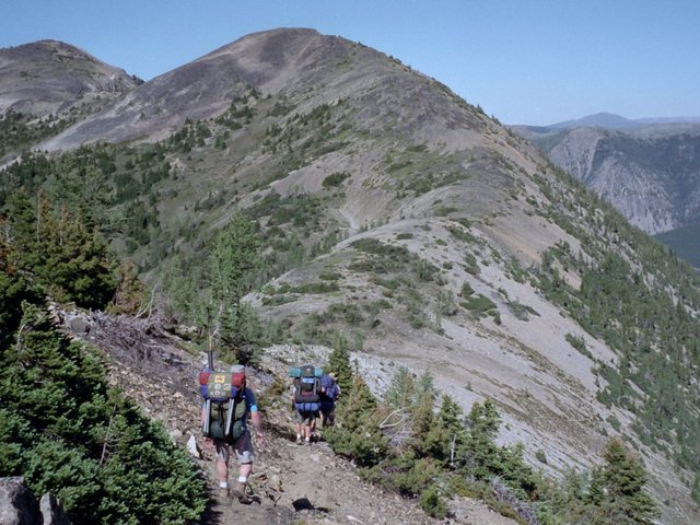
Beginning Descent from Top of Buckskin Ridge
A six day trip in the Pasayten Wilderness covering a little over 47 miles and with about 16000 feet of elevation gain and loss, including a wild goose chase at Buckskin Lake, a river that "flowed the wrong way", and a couple of 13 mile Death Marches (for me anyway).
Troop 24 Adults: "Cascade" Bill Mooseker, Greg Phillips
Troop 24 Scouts: Danny Stallings, Peter Goodwin, Shelby Stong, Roger Shively
Troop 24 "The High Adventure Troop" Backpacking Trip
-Cascade Bill Mooseker
Date(s): August 7-12, 2000. Album by Cascade Bill. Photos by Cascade Bill. 1 - 70 of 70 Total. 1528 Visits.
Hello Fellow Scouts ! Looks like a great trip ! I love that part of Washington ! I'm a Asst. Scoutmaster with Troop 714 based at St. Stephen The Martyr Church in Renton, WA. Stumbled on your site from a Google search !
Keep up the good work ! MC - Mark Cook, Wed, 30 Mar 2005 11:58AM
enlarge 193KB, 777x800 1 picsnvids
To enlarge photos, click on the thumbnail - the photo will pop up enlarged to 1024 pixels max (height or width). To view at Original size, just click on the enlarged photo, which will show the photo enlarged to fit the screen. Click on the screen to enlarge that portion of the photo at original resolution. Click again to reduce.
If you want to save photos to your computer, click the box under the thumbnails of all the photos you want to download. Then click the "Download" button at the top of the album. Pick the size you'd like to download (Original is best)and the photos will be downloaded as a zip file to the folder of your choice.
enlarge 86KB, 800x518 2 00-341-013 Shelby, Peter, Roger, Greg, and Danny at Slate pass (about 100 yds from trailhead) The Buckskin Ridge Trail takes off just a couple of switchbacks below the highest elevation that you can drive to in the state of Washington - the Slate Peak Lookout on peak in background.
enlarge 107KB, 800x561 3 00-341-014 Along Buckskin Ridge near Slate Pass.
enlarge 96KB, 800x554 4 00-341-015 Looking south - Robinson Pass at center
enlarge 70KB, 552x800 5 00-341-016 Greg fishing at Silver Lake - lots of small brookies.
enlarge 135KB, 800x523 6 00-341-018 Danny & Peter catchin a few rays in the late afternoon sun.
enlarge 91KB, 800x522 7 00-341-017 Shallow Silver Lake
enlarge 151KB, 800x518 8 00-341-019 Day 2 - Guys at Silver Pass
enlarge 119KB, 800x520 9 00-341-020 Valley on west side of Buckskin Ridge down from Silver Pass
enlarge 117KB, 522x800 10 00-341-021 Climbing up very steep stril on west side of Buckskin Ridge.
enlarge 93KB, 800x520 11 00-341-022 View from climb up Buckskin Ridge
enlarge 129KB, 800x519 13 00-341-024 Taking a break on climb up Buckskin Ridge.
enlarge 117KB, 800x522 14 00-341-025 Climbing over ridge crest down the eastern side of Buckskin Ridge.
enlarge 130KB, 800x600 15 00-341-025a Enlarged view of previous photo
enlarge 101KB, 527x800 16 00-341-026 Trail descends to this saddle and then switchbacks to the right down to a basin below.
enlarge 109KB, 800x521 17 00-341-027 Greg Phillips descending along ridge before dropping down switchbacks on east side of Buckskin Ridge.
enlarge 113KB, 800x520 18 00-341-028 Taking a break in the Meadowed Basin (far) below the ridge crest.
enlarge 118KB, 800x527 19 00-341-029 Day 3: Bill, Peter, Roger, Danny & Shelby - Leaving Buckskin Lake
enlarge 92KB, 800x520 20 00-341-030 Buckskin Lake - We would follow old abandoned trail on wild goose chase over pass above lake.
enlarge 86KB, 800x532 21 00-341-031 The Green Trails map shows the trail continuing along the ridge north of Buckskin Lake. But after a while our trail peters out - Where is the Trail?
enlarge 114KB, 800x527 22 00-341-032 Nothing but Meadows - no trail
enlarge 91KB, 800x525 23 00-341-033 Finally after heading back towards Buckskin Lake we find a faint trail, Lets see where it goes.
enlarge 105KB, 800x600 24 00-341-033a Heading along the trail above Buckskin Lake.
enlarge 91KB, 800x523 25 00-341-034 View of Buckskin Lake from the vague trail.
enlarge 80KB, 800x525 26 00-341-035 View from the ridge above Buckskin Lake.
enlarge 108KB, 800x522 27 00-341-036 Greg, Danny, and Roger following vague tread down opposite side of ridge (trail soon disappears and way is blocked by cliffs making a return to Buckskin Lake necessary.)
enlarge 134KB, 800x599 28 00-341-036a Enlarged view of previous photo
enlarge 67KB, 800x519 29 00-342-001 After our wild goose chase on an old abandoned sheep trail to nowhere we enjoy Moonlight and Campfire at Buckskin Lake - for 2nd night.
enlarge 132KB, 800x522 30 00-342-002 Bridge over river that runs the wrong way (due to a confusing Green Trails map we hiked a ways up the Point Defiance trail) - We found the correct trail out of Buckskin Lake and had to climb over hundreds of fallen logs that were over the unmaintained trail.
enlarge 141KB, 800x600 31 00-342-002a Enlarged view of previous photo - Greg, Danny, Peter, Shelby, and Roger.
enlarge 119KB, 800x521 32 00-342-005 Danny & Peter taking a dip in river. Brrrrr! That's cold!
enlarge 113KB, 800x531 33 00-342-004 Shelby watches Danny and Peter taking a dip in the stream.
enlarge 95KB, 800x526 34 00-342-006 Bill - about half way up Rock Creek - There's a campsite around here somewhere (a good half hour or so!) Climbing up Rock Creek, we met a Forest Service trail crew that had just finished clearing out an avalanche jungle of tumbled trees. There was one girl packing a 2-man saw that looked like she would win an arm wrestling match with any of us!
enlarge 122KB, 800x600 35 00-342-006a Enlarged view of previous photo - Unfortunately, we were never able to find "Brown Bear Camp" that was called out on the topo map, so we had to continue on to Coney Basin below Woody Pass. It was a really long day.
enlarge 73KB, 800x524 36 00-342-008 View of Rock Pass from our camp at Coney Basin.
enlarge 112KB, 800x521 37 00-342-009 Taking a breac at junction of Cascade Crest Trail/ Rock Cr. Trail in meadow below Woody Pass - Pete, Shelby, Roger, Danny, and Greg.
enlarge 87KB, 526x800 38 00-342-010 Descending switchbacks from Woody Pass onwards to Rock Pass.
enlarge 95KB, 800x522 39 00-342-011 Climbing up to Rock Pass - Looking north to Woody Pass.
enlarge 101KB, 800x523 40 00-342-012 Break at Rock Pass.
enlarge 117KB, 800x524 41 00-342-013 Break at Rock Pass - Pete, Shelby, Roger, Bill, and Danny.
enlarge 103KB, 800x600 42 00-342-013a Danny
enlarge 66KB, 800x528 43 00-342-014 Along Crest Trail south of Rock Pass.
enlarge 107KB, 800x536 44 00-342-015 Leaving Cascade crest Trail to head to Goat Lake.
enlarge 108KB, 550x800 45 00-342-016 Sunset at Goat Lake - We had a little bit of contention at our camp when Greg tore a page out of Peter's Fantasy novel and put it in the campfire. I later on read that same book and it turned out that that page was really crucial to the story!
enlarge 82KB, 800x522 46 00-342-017 Day 6 : Heading from Goat Lake back to Crest Trail. Rock Pass is to right of Peak.
enlarge 95KB, 800x527 47 00-342-018 We Were Lost! - Bill, Shelby, Roger, Peter, & Danny - They'll never let me forget the "River that runs the wrong way"!
enlarge 129KB, 686x800 48 00-342-018b Peter & Danny
enlarge 94KB, 545x800 49 00-342-018a Shelby & Roger
enlarge 76KB, 800x530 50 00-342-019 View along Crest Trail before descending to Holman Pass. Along this stretch, we met a "Thru-Hiker" that had done the entire trail from Mexico to Canada and was on the return trip. Hope he made it before the snows fell.
enlarge 93KB, 800x526 57 00-342-025 Looking back to Windy Pass.
enlarge 89KB, 800x523 58 00-342-026 Ridge hugging Crest Trail a couple of miles south of Windy Pass
enlarge 86KB, 800x533 59 00-342-027 Basin along Crest Trail.
enlarge 64KB, 800x535 60 00-342-028 Beautiful section of trail south of Windy Pass - we had planned on camping at the pass but it was mediocre at best so we decided to push on out to the trailhead.