Day 0: May 12:
Explore rim of Todie Canyon
Camp at Trailhead for Todie Canyon.
Day 1: May 13:
Head down Access #4 to Camp 1 at meadow.
Day 2: May 14:
Continue down Access #4 to mouth of Slickhorn.
Hike up Slickhorn to Camp 2 near mouth of Access #2.
Day 3: May 15:
Dayhike up Slickhorn from Camp 2 to visit Kiva Ruin
and other ruins above 2nd Access.
Head down canyon past Access #4 to Camp 3 at
mouth of Trail Canyon (Access #6).
Day 4: May 16:
Start up Trail Canyon (Access #6) & visit Big Ledge Ruins
Continue up canyon to trailhead, retrieve car, &start long drive back.
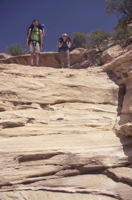
Nick & Allison - Pondering How to Get Down Dropoff
For our fourteenth trip to the canyons of southern Utah, we did a partial repeat of our 2004 trip to Slickhorn Canyon. This was mainly due to traveling in one car limits your options for a loop trip. This is a very scenic canyon complex with many opportunities for visiting ruins or Anazazi art.
While hiking in the main Slickhorn Canyon is fairly easy, going in and out via the access canyons is fairly hard for a 60 year old (as I was in 2004) and even more so as a 71 year old. I'm ever grateful to the younger Kickass Trekkers for making it possible for me to continue doing what I love. In 2004, I wasn't thinking about how much longer I would be backpacking, but now I realize that each year onward is a gift.
Note photos ending in "b" are by Bill; "a" are by Allison; and "j" by Joel.
Kickass Trekkers on this trip were: Bill Mooseker, Joel Fuller, Nick McMahan, and Allison Walkingshaw.
The descriptions under the photo thumbnails in the album sometimes contain links to maps or additional information. These are identified by "Blue” text for links. I've also inserted links to Google Maps to show where certain photos in the album were taken or to locate features shown in the photos. Click on the link, close the sidebar, and choose satellite view. Basically, you can then zoom in and out using the mouse wheel or drag the map by clicking and holding.
The thumbnails do not do justice to petroglyphs and pictographs, so I would recommend enlarging them as well. Please take the time to view the videos to better experience what it was like to be there.
Troop 24 Kickass Trekkers Backpacking Trip
-Cascade Bill Mooseker
Date(s): May 11-17, 2015. Album by Cascade Bill. 1 - 375 of 375 Total. 9606 Visits.
To get the plugin just Google "videolan" or CLICK HERE FOR DOWNLOAD for Windows. There is a MAC version as well. Disable the Quicktime plugin if you use Videolan.
If you want to save photos to your computer, click the box under the thumbnails of the photos you want to download. Then click the "Download" button at the top of the album. Pick the size you'd like to download (Original is best)and the photos will be downloaded to a folder of your choice.
enlarge 137KB, 768x1024 2 2015-05-11 06-53-07 - utah 2015-001-j Getting ready to depart after packing car. We were fully loaded with roof top carrier. Picked up Allison at park-n-ride in Bellevue near I-90. Our destination for the day was the Marble Motel in Tremonton, Utah and traditional dinner at the Tremonton Denny's.
enlarge 160KB, 1024x768 3 2015-05-12 12-14-33 - utah 2015-002-j View from car south of Price, Utah.
enlarge 209KB, 1024x768 4 2015-05-12 14-44-29 - utah 2015-003-j Hollow Mountain Gas Station in Hanksville, Utah. Made our usual stop at Blondies for lunch in Hanksville.
enlarge 284KB, 1024x768 5 2015-05-12 16-44-45 - utah 2015-004-j Allison and Nick at our campsite near the Todie Canyon trailhead. The Kane Ranger Station is only open till noon, so we couldn't pick up our permit until the next morning. Todie Canyon is fairly close to the Ranger station so we didn't lose too much time in getting a permit the next day. Our camp was located: HERE
enlarge 213KB, 1024x768 6 2015-05-12 17-36-45 - utah 2015-005-j Since we were in camp fairly early and there was quite a lot of daylight left, we decided to hike out along the rim of Todie Canyon.
enlarge 383KB, 1024x768 7 2015-05-12 17-41-02 - P1000735%a At this point (near the trailhead), the canyon is not very deep.
enlarge 404KB, 1024x768 8 2015-05-12 17-42-31 - P1000738%a Allison got this shot of a very red Indian Paintbrush.
enlarge 230KB, 1024x768 10 2015-05-12 17-42-47 - P1000739%a Nick & Joel - in the distance you can see me (Bill). In the distance is Moss Back Butte. Photo taken HERE.
enlarge 224KB, 1024x768 11 2015-05-12 17-43-03 - utah 2015-006-j Another view from same spot looking down into canyon.
enlarge 299KB, 1024x768 12 2015-05-12 17-43-09 - DSC00781-b Photo is looking back towards Joel, Nick, and Allison, where the previous pictures were taken.
enlarge 316KB, 1024x768 13 2015-05-12 17-43-16 - P1000740%a Allison's photo looking down photo -Bill is still across the way.
enlarge 304KB, 768x1024 14 2015-05-12 17-44-03 - P1000741%a Large Blocks at canyon rim.
enlarge 264KB, 1024x768 15 2015-05-12 17-44-48 - P1000742%a View of farther block from previous photo - location HERE.
enlarge 267KB, 1024x768 16 2015-05-12 17-51-21 - DSC00782-b Further along down canyon near rim access to Todie Canyon.
enlarge 297KB, 1024x768 17 2015-05-12 17-55-49 - DSC00783-b Looking back towards location of previous photo. This is the point at which you can descend down to the floor of Todie Canyon. Location is: HERE.
enlarge 299KB, 1024x768 18 2015-05-12 17-56-24 - DSC00785-b Here's where you go down into Todie - very steep and brushy. From the guide book there is a down climb off a boulder.
enlarge 317KB, 1024x768 19 2015-05-12 17-56-44 - DSC00786-b Another view of the access(??) - Joel and Nick decided to try it out and go down. Too much for me.
enlarge 267KB, 768x1024 20 2015-05-12 17-56-54 - P1000743%a Joel fooling around in crack at canyon rim.
enlarge 275KB, 768x1024 21 2015-05-12 17-57-10 - P1000744%a Joel, there doesn't seem to be a bottom to that thing!
enlarge 356KB, 1024x768 23 2015-05-12 18-04-30 - DSC00788-b Looking down into canyon - access is to the right.
enlarge 322KB, 1024x768 24 2015-05-12 18-04-52 - DSC00789-b If you enlarge this photo, you can see Nick descending to the floor of the Canyon - he is to the right of the center of the photo. You can see how steep it is - "Not recommended for novices" (or Septuagenarians, I might add).
enlarge 309KB, 1024x768 25 2015-05-12 18-07-46 - DSC00790-b View slightly down canyon from previous photo.
enlarge 215KB, 768x1024 26 2015-05-12 18-13-53 - P1000745%a Photo of Large Blocks at canyon rim - this is at a small side canyon located HERE.
enlarge 188KB, 1024x768 27 2015-05-12 18-14-04 - P1000746%a Another view of same block.
enlarge 314KB, 1024x768 28 2015-05-12 18-14-30 - P1000747%a View looking down side canyon into the main Todie Canyon.
enlarge 270KB, 1024x768 29 2015-05-12 18-29-10 - P1000752%a Allison got this photo of a little rattlesnake along the trail. I think that it is a Green Prairie Rattlesnake see THIS for info and photos.
enlarge 300KB, 1024x768 30 2015-05-12 18-30-17 - DSC00791-b I found a way around the side canyon and continued along the rim. This shows a large side canyon (Long Flat Canyon) joining the main canyon. The mouth of the canyon is located HERE.
enlarge 313KB, 1024x768 31 2015-05-12 18-31-30 - DSC00792-b Telephoto view of the mouth of Long Flat from south rim of Todie.
enlarge 313KB, 1024x768 32 2015-05-12 18-34-24 - DSC00793-b Todie Canyon just down canyon from Long Flat.
enlarge 289KB, 1024x768 33 2015-05-12 18-35-09 - P1000753%a Allison's photo of a series of "potholes" eroded into the sandstone.
enlarge 270KB, 768x1024 34 2015-05-12 18-35-15 - P1000754%a Another view.
enlarge 201KB, 1152x491 35 2015-05-12 18-36-49 - utah 2015-008-j Meanwhile, down in the canyon, Joel and Nick discovered some ruins. Here is a series of small granaries.
enlarge 252KB, 1024x768 36 2015-05-12 18-38-21 - utah 2015-009-j Nick at Ruin. Notice how high on the north wall of the canyon they are. The ruin at the right foreground is the one at the left of the previous photo.
enlarge 187KB, 1024x768 37 2015-05-12 18-39-55 - utah 2015-010-j A view looking down canyon along the ledge.
enlarge 179KB, 1024x768 38 2015-05-12 18-41-30 - utah 2015-011-j Nick walking along ledge.
enlarge 210KB, 1024x768 39 2015-05-12 18-42-48 - utah 2015-012-j Photo taken further along the ledge and around the bend of the previous photo.
enlarge 249KB, 1024x768 40 2015-05-12 18-48-44 - utah 2015-013-j Nick approaching ruins. This is beyond the bend of the previous photo.
enlarge 275KB, 1024x768 41 2015-05-12 18-59-31 - utah 2015-014-j Shot of group of ruins tucked under the overhang.
enlarge 142KB, 1024x768 42 2015-05-12 19-11-57 - utah 2015-015-j Joel got this photo of the sunset as they were heading back.
enlarge 249KB, 1024x768 43 2015-05-12 18-43-39 - DSC00794-b As I progressed along the rim, I got to where I could see the junction of Todie Canyon with the main canyon of Grand Gulch. Todie is the canyon from the bottom right; Grand Gulch comes in from the right making a big backwards "S" turn as it goes down canyon.
enlarge 232KB, 1024x768 44 2015-05-12 18-43-51 - DSC00795-b Another shot - That is Grand Gulch going around the far bend.
enlarge 326KB, 1024x768 45 2015-05-12 18-45-29 - DSC00796-b Looking back up "Long Flat" Canyon - ironically, there is a website for hiking Toadie (sic) Canyon that has this same photo and is captioned "Grand Gulch".
enlarge 137KB, 1024x768 46 2015-05-12 19-15-13 - DSC00797-b As I was heading back, I got this photo of the sun setting to the left of Moss Back Butte.
enlarge 302KB, 1024x768 47 2015-05-13 10-15-16 - DSC00798-b After getting up and getting our gear ready for the hike, we drove back to the Kane Ranger station to get our permit (after watching a mandatory video on do's and don'ts in the Grand Gulch).
It is a long drive to get to the "Trailhead" (Slickhorn Access #4 - located HERE) over questionable roads (for Joel's Honda as loaded down as it was). We made it OK with only a few scrapes. In 2004, we moved the car down to our exit point, but we didn't want to risk the extra mileage.
enlarge 243KB, 1024x768 48 2015-05-13 10-20-33 - P1000755%a Joel and Nick heading down canyon. Because of the long drought in the area, I had been worried that if we got stuck at the trailhead when we were on our way out due to bad roads, etc. that we wouldn't have any water. As you can see in this and the previous photo, there were pools of water just a short distance from the TH.
enlarge 288KB, 1024x768 49 2015-05-13 10-33-46 - DSC00801-b Unusual rock formation on the way down - notice the bedding in the sandstone slickrock.
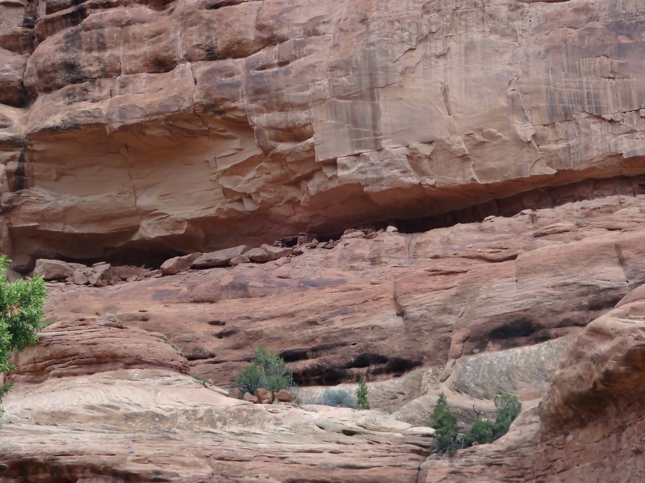
enlarge 402KB, 1024x768 50 2015-05-13 11-12-17 - DSC00806-b About a mile from the trailhead, the canyon opens up a bit. About a quarter of a mile further, a small granary can be seen on the north side of the canyon. This view is from the overhang containing the ruin.
enlarge 191KB, 768x1024 51 2015-05-13 11-04-21 - P1000756%a Nick at the ruin.
enlarge 240KB, 1024x768 55 2015-05-13 11-07-24 - DSC00802-b Nick and Allison under the overhang.
enlarge 243KB, 1024x768 56 2015-05-13 11-09-22 - P1000760%a Nick, Joel, and Bill (I finally got up there)
enlarge 230KB, 1024x768 57 2015-05-13 11-11-58 - DSC00805-b Nick and Joel. I wonder if those big boulders were moved there in order to construct the ruin.
enlarge 322KB, 1024x768 58 2015-05-13 11-12-05 - DSC00804-b Allison taking a break in the shade.
enlarge 258KB, 1024x768 60 2015-05-13 11-30-51 - DSC00809-b After exploring the ruin, Nick and I continued along the ledge to this viewpoint.
enlarge 268KB, 1024x768 61 2015-05-13 11-31-00 - DSC00811-b Another shot.
enlarge 253KB, 1024x768 62 2015-05-13 11-31-16 - DSC00812-b Nick
enlarge 338KB, 1024x768 63 2015-05-13 11-31-38 - DSC00813-b Viewpoint looking down canyon - you can see the pouroff where the canyon drops off much faster. The location of the viewpoint is HERE.
enlarge 323KB, 1024x768 64 2015-05-13 12-19-19 - P1000763%a About 1.5 miles from the trailhead, this pouroff is reached, and you can see that the canyon drops sharply from this point. This point is located HERE.
enlarge 334KB, 768x1024 65 2015-05-13 12-19-10 - P1000762%a There is a way around the pouroff on the left - it is very steep. I slipped on a loose rock and took a bad fall coming down, and ending up sprawled head first balanced on a boulder and couldn't move. Fortunately, Nick soon arrived to get me back up. If you enlarge the photo you can see me and Nick making our way down.
enlarge 253KB, 1024x768 66 2015-05-13 12-30-58 - P1000765%a Joel and Bill in the shade of the Pouroff. I'm doing first aid on my hand as I had injured it during my fall.
enlarge 249KB, 1024x768 67 2015-05-13 12-31-49 - P1000764%a Nick on the north rim taking in the view.
enlarge 214KB, 1024x678 69 2015-05-13 12-33-49 - utah 2015-018-j Below the pouroff, the going gets a lot rougher as you can see with all of these boulders.
enlarge 243KB, 1024x678 70 2015-05-13 12-34-19 - utah 2015-019-j Looking back at the pouroff - you can see me doing first aid.
enlarge 163KB, 1024x678 71 2015-05-13 13-27-35 - utah 2015-020-j Bill on slickrock as seen through a boulder tunnel.
enlarge 181KB, 678x1024 72 2015-05-13 13-27-50 - utah 2015-021-j Whoa! Looking for a way down.
enlarge 326KB, 1024x768 73 2015-05-13 13-28-22 - DSC00814-b I think these are Sego Lilies about to bloom.
enlarge 300KB, 1024x768 74 2015-05-13 13-44-00 - DSC00815-b Joel making his way down the canyon.
enlarge 292KB, 768x1024 75 2015-05-13 13-47-41 - P1000766%a Joel at center.
enlarge 324KB, 1024x768 76 2015-05-13 13-47-47 - P1000767%a A lot of boulder hopping through here (Nick's pack behind rock).
enlarge 252KB, 768x1024 77 2015-05-13 13-51-23 - P1000768%a Bill & Nick coming down - Nick went back and carried my pack down through a difficult stretch - (Nick's pack to right of center)
enlarge 291KB, 1024x768 78 2015-05-13 13-51-46 - P1000769%a A big drop beyond here. I think that this photo was taken HERE
enlarge 180KB, 678x1024 79 2015-05-13 14-07-30 - utah 2015-022-j Joel going down canyon.
enlarge 315KB, 1024x768 89 2015-05-13 15-09-23 - P1000774%a Joel, Nick, and Allison were waiting for Bill HERE while Bill was waiting for them HERE. There are many "trails" here and there and we took different paths (I took the wrong one to a point at which the canyon was blocked by a big house sized boulder).
enlarge 372KB, 768x1024 90 2015-05-13 15-23-09 - DSC00820-b The next obstacle (and the last of the day) was just a few yards down canyon from the house sized boulder cited previously.
enlarge 394KB, 768x1024 91 2015-05-13 15-23-33 - P1000775%a Nick negotiating the obstacle.
enlarge 314KB, 768x1024 92 2015-05-13 15-23-39 - P1000776%a Nick brought Allison and Bill's packs down previously. I remember this spot from 2004 - Hard for me even without a backpack on. Spot is located HERE.
enlarge 365KB, 1024x768 93 2015-05-13 15-23-46 - P1000777%a Took a break after the last obstacle.
enlarge 331KB, 1024x768 94 2015-05-13 15-38-42 - DSC00825-b After a short hike we found ourselves in this nice meadow.
enlarge 378KB, 1024x768 95 2015-05-13 15-38-45 - P1000779%a Bill getting some photos of flowers in the meadow.
enlarge 482KB, 1024x768 96 2015-05-13 15-39-27 - DSC00822-b Globemallow flowers, See Globemallows for more information.
enlarge 224KB, 678x1024 101 2015-05-13 15-48-40 - utah 2015-026-j Bill in meadow - There was a good camping spot in this meadow, and as we had gotten a late start and had quite a bit of hiking to do before we reached the mouth of the canyon, we decided to camp HERE for the night.
enlarge 205KB, 1024x678 102 2015-05-13 15-52-39 - utah 2015-027-j Looking back up canyon from camp.
enlarge 277KB, 678x1024 103 2015-05-13 16-05-00 - utah 2015-028-j Nick climbing up the north wall of the canyon near our camp.
enlarge 181KB, 678x1024 106 2015-05-13 16-16-13 - utah 2015-031-j Looking back at the meadow where our camp is located.
enlarge 235KB, 1024x768 107 2015-05-14 09-27-12 - P1000781%a Allison got this shot from her tent in the morning. During the night, the weather changed and we were subjected to thunder storms and pounding rain. In the morning, the rain kept up and we didn't feel like getting up and making breakfast and breaking camp in the rain, so we waited in our tents to the sounds of a bubbling brook near our tents due to "flash" flooding.
enlarge 193KB, 1024x678 108 2015-05-14 11-14-21 - utah 2015-032-j Clouds breaking up a little bit - you can see Allison, Nick, and Bill getting breakfast (lunch!) ready.
enlarge 413KB, 1024x768 110 2015-05-14 12-30-13 - DSC00826-b View of our camp - you can see my new Six Moons Designs Trekker 24 ounce solo tent (green tent). Very roomy and comfortable and weathered the storm very well.
enlarge 344KB, 1024x768 111 2015-05-14 12-30-33 - DSC00827-b Joel packing up his tent.
enlarge 405KB, 1024x768 112 2015-05-14 12-30-40 - DSC00828-b Allison in her tent.
enlarge 322KB, 1024x768 123 2015-05-14 14-00-47 - DSC00829-b Faint pictographs at large alcove with several ruins. We missed this one on our 2004 trip.
enlarge 232KB, 1024x768 136 2015-05-14 14-03-53 - DSC00836-b showing mud daubing seal at roof of alcove plastering in place a large flat rock.
enlarge 271KB, 1024x768 137 2015-05-14 14-04-07 - DSC00837-b Mud daubing and stick reinforcement at base of large flat rock - you can see where fingers have worked the mud into place.
enlarge 336KB, 1024x768 138 2015-05-14 14-05-39 - DSC00842-b Looking at the back side of granary.
enlarge 244KB, 1024x768 139 2015-05-14 14-06-45 - DSC00846-b close up of floor of 2nd story of granary. Also it is clear that the adjacent portion of the granary has collapsed.
enlarge 201KB, 1024x768 141 2015-05-14 14-07-24 - DSC00844-b Lower door in granary.
enlarge 245KB, 768x1024 142 2015-05-14 14-07-50 - P1000800%a Upper door of granary.
enlarge 264KB, 1024x768 143 2015-05-14 14-08-32 - DSC00845-b Close up of lintel of the upper door showing how the wooden logs have been lashed together (where the outer mud daubing has fallen away).
enlarge 338KB, 768x1024 144 2015-05-14 14-15-34 - P1000798%a Shot of down canyon end of the granary.
enlarge 306KB, 1024x768 145 2015-05-14 14-16-34 - DSC00852-b ruin of the collapsed end of the granary.
enlarge 327KB, 1024x768 146 2015-05-14 14-16-47 - DSC00853-b Wall construction - stick and mud with flat rock.
enlarge 245KB, 1024x768 147 2015-05-14 14-16-55 - DSC00854-b Examples of mud daubing that was probably the floor of the 2nd story of the granary, as you can see the impressions of the sticks to which the mud was applied.
enlarge 330KB, 1024x768 148 2015-05-14 14-17-08 - DSC00851-b Another view of granary and pictograph panel.
enlarge 233KB, 1024x768 155 2015-05-14 14-20-05 - DSC00847-b Large boulder showing grooves left from grinding grain.
enlarge 280KB, 1024x768 156 2015-05-14 14-20-20 - DSC00848-b Another view of the grooves worn into the rock.
enlarge 230KB, 1024x768 157 2015-05-14 14-20-31 - DSC00849-b More grooves in the top of the boulder.
enlarge 296KB, 1024x768 158 2015-05-14 14-20-48 - DSC00850-b View of the alcove.
enlarge 401KB, 1024x768 159 2015-05-14 14-20-50 - P1000797%a Down at the end of the alcove, the ground was pretty wet, but there were more pictographs, which Bill is photographing.
enlarge 346KB, 1024x768 160 2015-05-14 14-20-54 - DSC00855-b Pictograph panel at end of alcove.
enlarge 311KB, 1024x768 161 2015-05-14 14-21-04 - DSC00856-b Close up of figure - that is some headdress!
enlarge 408KB, 1024x768 163 2015-05-14 14-22-12 - DSC00858-b Closeup of Big horn sheep figure.
enlarge 525KB, 1024x768 164 2015-05-14 14-22-54 - DSC00859-b Pure white Columbines (which are appropriately named: Alcove Columbines) growing at this end of the alcove.
enlarge 329KB, 1024x768 165 2015-05-14 14-28-21 - DSC00860-b Allison and Nick going to get their packs.
enlarge 183KB, 1024x678 166 2015-05-14 14-31-23 - utah 2015-044-j Packs on, Allison and Nick head down canyon.
enlarge 353KB, 1024x768 167 2015-05-14 14-28-21 - DSC00860-b I found these yellow Monkey flowers - usually in the cascades, these grow along streams. These desert cousins are making do with much drier conditions.
enlarge 333KB, 768x1024 168 2015-05-14 14-42-29 - P1000801%a The hiking is easier the nearer the end of the canyon approaches. You can see the mud left over from the previous night's storm.
enlarge 300KB, 1024x768 169 2015-05-14 14-43-13 - DSC00861-b I was ahead of the rest and got this shot. Note large boulder to right of center as well as house sized boulder further down canyon.
enlarge 318KB, 1024x768 170 2015-05-14 14-42-37 - P1000802%a Joel and Nick hiking down canyon.
enlarge 218KB, 678x1024 171 2015-05-14 14-45-15 - utah 2015-045-j Allison (looking up canyon). Weather is improving as the sun is now out. See THIS PHOTO from our 2004 trip that was taken near this point showing Eric Walkinshaw with Allison right behind him.
enlarge 300KB, 768x1024 172 2015-05-14 14-45-22 - P1000803%a Another view - see the Large boulder that was noted in the previous photo.
enlarge 202KB, 1024x678 173 2015-05-14 14-45-27 - utah 2015-046-j Nick passing house sized boulder that was noted in previous photo. This location in the canyon is HERE.
enlarge 284KB, 768x1024 174 2015-05-14 14-45-29 - P1000804%a Joel at the same location with Nick further down canyon.
enlarge 319KB, 768x1024 175 2015-05-14 14-45-45 - P1000805%a View near the huge boulder, which is at the upper right of the photo.
enlarge 392KB, 1024x768 176 2015-05-14 14-46-48 - DSC00863-b Looking back up the canyon from near the Huge boulder, which is now on the left.
enlarge 297KB, 1024x768 177 2015-05-14 14-51-04 - DSC00864-b View looking down canyon near the end of Access #4.
enlarge 214KB, 678x1024 178 2015-05-14 15-02-38 - utah 2015-048-j Taking a break at the mouth of Access #4 in the main Slickhorn Canyon. The location of our break is HERE.
enlarge 289KB, 1024x768 179 2015-05-14 15-16-07 - P1000807%a very prominent headland of Slickhorn Canyon at the mouth of Access #4.
enlarge 370KB, 1024x768 180 2015-05-14 15-22-15 - DSC00868-b Mouth of Access #4. Note that Slickhorn wash is dry after the previous night's rain.
enlarge 239KB, 1024x768 181 2015-05-14 15-22-18 - DSC00867-b Looking down Slickhorn - As you come to the mouth of Access #4, it seems that the main Slickhorn is a continuation of Access #4 and that the up canyon branch of Slickhorn is merely a side branch.
enlarge 304KB, 1024x768 182 2015-05-14 15-22-50 - P1000808%a Nick doing a little exploration during our break at the mouth of Access #4.
enlarge 175KB, 1024x678 183 2015-05-14 15-26-15 - utah 2015-049-j Joel's photo of a Claret Cup Cactus bloom.
enlarge 256KB, 1024x768 184 2015-05-14 15-31-41 - DSC00870-b Very beautiful section of the canyon above the mouth of Access #4.
enlarge 181KB, 1024x678 185 2015-05-14 15-31-49 - utah 2015-050-j Almost to the junction of Access #2/3.
enlarge 319KB, 1024x768 186 2015-05-14 15-38-11 - P1000813%a Coming up to our camp site.
enlarge 428KB, 768x1024 187 2015-05-14 15-38-24 - P1000812%a Looking back down canyon - you can see Joel in the distance, if you enlarge the photo.
enlarge 215KB, 1024x678 189 2015-05-14 15-32-02 - utah 2015-051-j Joels photo of the mouth of Access of #2/#3. Our camp was in the grove of trees to the left of the headland at the center of the photo. Joel, Nick, and Allison climbed up the west side of the canyon after we arrived at camp, as there was plenty of daylight left.
enlarge 284KB, 1024x768 190 2015-05-14 16-24-42 - P1000821%a View showing the ledge above the canyon.
enlarge 213KB, 1024x678 191 2015-05-14 15-50-16 - utah 2015-052-j Looking at the southern headland for Access #2/#3.
enlarge 159KB, 1024x678 192 2015-05-14 15-51-19 - utah 2015-053-j A small granary in an alcove high on the canyon wall.
enlarge 226KB, 1024x768 193 2015-05-14 16-24-29 - P1000820%a Nick at granary.
enlarge 188KB, 678x1024 194 2015-05-14 15-53-52 - utah 2015-054-j View looking at the mouth of Access #2/#3 as it enters the main canyon.
enlarge 299KB, 1024x768 195 2015-05-14 16-09-37 - P1000815%a Joel and Nick on ledge- Pictograph panel is to the left.
enlarge 242KB, 1024x768 197 2015-05-14 16-10-36 - P1000818%a Nick & Joel at pictograph panel.
enlarge 239KB, 1024x768 198 2015-05-14 16-10-42 - P1000819%a Another view.
enlarge 140KB, 678x1024 199 2015-05-14 16-09-22 - utah 2015-055-j Closeup of Pictographs on wall of canyon.
enlarge 137KB, 678x1024 200 2015-05-14 16-09-34 - utah 2015-056-j Pictograph of ghostly human figure. Compare this to the ones shown previously at the kiva alcove.
enlarge 277KB, 1024x768 202 2015-05-14 16-09-54 - P1000816%a View of our camp from ledge.
enlarge 195KB, 678x1024 203 2015-05-14 16-23-04 - utah 2015-058-j Another view of our camp from ledge.
enlarge 273KB, 1024x768 204 2015-05-14 16-10-12 - P1000817%a Headland separating the main canyon and the mouth of Access #2/#3. If you enlarge the photo to original size, you will see me in camp (the white dot in the trees to the left of center.
enlarge 374KB, 1024x768 205 2015-05-14 17-47-12 - P1000822%a Dinner time - this is a great camp.
enlarge 398KB, 1024x768 206 2015-05-14 17-47-32 - P1000823%a Layout of our tents - we had some rain during the night.
enlarge 340KB, 1024x768 207 2015-05-14 17-47-52 - P1000824%a Another shot of our camp.
enlarge 126KB, 1024x768 208 2015-05-14 21-04-18 - utah 2015-059-j After dinner, Joel and Nick climbed to a ledge on the eastern side of the canyon and got this shot of this oft photographed "Hoodoo" that seems to appear in every Slickhorn web page.
enlarge 200KB, 1024x768 209 2015-05-14 21-16-24 - utah 2015-060-j Nick on the ledge.
enlarge 183KB, 1152x402 210 2015-05-14 21-20-16 - utah 2015-061-j Panoramic view from the ledge on the eastern side of Slickhorn. Our camp is in the green area above the boulder at the center of the photo.
enlarge 364KB, 1024x768 212 2015-05-15 08-51-50 - DSC00872-b Breakfast - my new tent is the green one.
enlarge 243KB, 768x1024 213 2015-05-15 09-37-16 - P1000825%a After breakfast, Joel and nick decide to explore a ledge on this headland, northwest of our camp. If you enlarge this to original size and you look closely, you can see them on the ledge.
enlarge 268KB, 768x1024 214 2015-05-15 09-37-16 - P1000828%a Nick and Joel on the ledge - looks pretty scary to me.
enlarge 191KB, 1024x768 215 2015-05-15 09-37-31 - P1000826%a Inspecting the pictographs on the ledge (Enlarge photo to Original Size) to see them.
enlarge 216KB, 1024x768 216 2015-05-15 09-38-04 - P1000827%a Another view - If you enlarge to Original Size, you can see that they are laughing at something.
enlarge 219KB, 1024x768 217 2015-05-15 09-39-47 - DSC00873-b Walking along the ledge.
enlarge 93.62MB, 1152x648 Download MPEG4 218 day2-1.mp4 VIDEO - Click Photo to View. Video of Joel and Nick on ledge west of camp.
enlarge 277KB, 768x1024 228 2015-05-15 11-00-05 - P1000837%a Making our way up the trail, you can see the alcove that contains the Perfect Kiva, framed by the trees on either side of the trail.
enlarge 215KB, 678x1024 229 2015-05-15 11-02-48 - utah 2015-063-j Bill, Allison, and Nick are just about to the point where the climb to the kiva.
enlarge 206KB, 678x1024 230 2015-05-15 11-03-27 - utah 2015-064-j Remnants of the previous night's rain are visible.
enlarge 388KB, 1024x768 231 2015-05-15 11-03-49 - DSC00876-b Joel - if you enlarge the photo to Original size, you can make out a small ruin in the Perfect Kiva alcove ahead.
enlarge 182KB, 1024x678 233 2015-05-15 11-13-20 - utah 2015-065-j Nick at the Perfect Kiva alcove - the stone circle demarks the area where you should'nt walk on the fragile roof structure.
enlarge 264KB, 1024x768 234 2015-05-15 11-13-21 - P1000845%a Entrance to the kiva - ladder at right - chimney for smoke at the left.
enlarge 239KB, 1024x768 235 2015-05-15 11-13-29 - DSC00879-b Another view of the entrance to the kiva.
enlarge 94KB, 678x1024 237 2015-05-15 11-14-29 - utah 2015-066-j Nick entering kiva on ladder.
enlarge 112KB, 1024x678 238 2015-05-15 11-15-25 - utah 2015-069-j Nick in kiva.
enlarge 101KB, 678x1024 239 2015-05-15 11-16-27 - utah 2015-070-j view of entrance ladder from side. note chimney opening at left.
enlarge 228KB, 768x1024 240 2015-05-15 11-20-40 - P1000838%a view of ladder, and roof structure.
enlarge 158KB, 1024x768 241 2015-05-15 11-20-50 - P1000839%a Inside of kiva - I don't know why there is a demarcation between the fire blackened and natural clay wall.
enlarge 297KB, 1024x768 243 2015-05-15 11-23-22 - P1000841%a view of the alcove and kiva.
enlarge 261KB, 1024x768 244 2015-05-15 11-23-27 - P1000842%a There is an ammo box with info about the kiva - Nick and Joel are reading these materials.
enlarge 323KB, 1024x768 245 2015-05-15 11-24-19 - P1000843%a Pottery shards at the site.
enlarge 322KB, 768x1024 246 2015-05-15 11-24-52 - P1000844%a The northern ledge of the alcove.
enlarge 384KB, 1024x768 247 2015-05-15 11-26-16 - P1000846%a Looking down into Slickhorn canyon from the alcove - it is quite a climb (for me anyways). There are some rock cairns here and there, but there is no definitive way to the top. You just pick your way as you see fit.
enlarge 184KB, 1024x678 248 2015-05-15 11-26-49 - utah 2015-071-j Allison and some of the other ruins in the alcove.
enlarge 235KB, 1024x768 249 2015-05-15 11-33-39 - P1000849%a view of the kiva roof - the white rectangle in the foreground is a notice not to walk on the roof area.
enlarge 173KB, 1024x678 250 2015-05-15 11-34-42 - utah 2015-074-j Bill (I finally made it up), Allison, and Nick.
enlarge 168KB, 1152x363 251 2015-05-15 11-34-48 - utah 2015-076-j Panoramic view of Alcove (Nick is at the left, reading the info on the alcove.
enlarge 237KB, 1024x768 255 2015-05-15 11-44-36 - DSC00881-b Collapsed Ruin- I think that this was a partial stone and log structure.
enlarge 233KB, 1024x768 256 2015-05-15 11-44-47 - DSC00882-b View of the inside of the collapsed ruin. Note smoke blackened walls and roof.
enlarge 269KB, 1024x768 257 2015-05-15 11-45-11 - DSC00892-b Granary at the north side of the collapsed ruin - construction is much different, with mud mortared rocks rather than just rock and log construction.
enlarge 290KB, 1024x768 258 2015-05-15 11-45-12 - DSC00883-b Very small ruin - don't know what it was for.
enlarge 238KB, 1024x768 259 2015-05-15 11-45-39 - utah 2015-072-j Turkey pictograph - very different in style than the ones down canyon.
enlarge 186KB, 1024x768 260 2015-05-15 11-45-43 - DSC00885-b View looking south from alcove - Enlarge photo to Original Size and you can see Joel and Nick as they have climbed to the canyon rim. Ten minutes ago they were in the alcove - it would probably take me half a day to get there even if I could make it.
enlarge 251KB, 1024x768 261 2015-05-15 11-45-44 - P1000850%a Another view.
enlarge 168KB, 1024x768 262 2015-05-15 11-46-04 - DSC00886-b View of Nick and Joel on rim.
enlarge 146KB, 1024x768 263 2015-05-15 11-46-15 - DSC00887-b Joel waving to us.
enlarge 215KB, 1024x768 264 2015-05-15 11-46-31 - P1000851%a Another view.
enlarge 262KB, 1024x768 265 2015-05-15 11-48-07 - DSC00888-b This granary is the ruin that you can see from the canyon floor (see previous photos). Allison and I are walking the ledge on the north side of the alcove.
enlarge 267KB, 1024x768 266 2015-05-15 11-51-02 - P1000855%a Following the ledge around the bend, we come to this small alcove, which contains an unusual pictograph panel.
enlarge 167KB, 1024x768 268 2015-05-15 11-52-03 - DSC00891-b Another view. Is the curvy line a snake? A river? Why does it have a ball at the beginning (end). Why is the last part of the line white and not red? Are those white forms another style of turkeys? What is the black animal at top right?
enlarge 208KB, 1024x768 269 2015-05-15 11-52-21 - P1000854%a Hand prints with spiral palms.
enlarge 185KB, 1024x768 270 2015-05-15 11-52-24 - DSC00890-b Closeup of hand prints.
enlarge 271KB, 1024x768 273 2015-05-15 12-05-57 - P1000858%a Before we headed down, Allison and I walked out the ledge south of the kiva. This is a shot looking back towards the kiva - you can see me making my way back.
enlarge 250KB, 1024x768 274 2015-05-15 12-11-44 - P1000860%a Allison's photo of a pottery shard - this would have been a very beautiful piece if it had survived.
enlarge 269KB, 768x1024 275 2015-05-15 12-21-20 - P1000861%a Allison's photo looking up canyon as she was almost all the way down from climbing down from the kiva.
enlarge 404KB, 768x1024 276 2015-05-15 12-21-29 - P1000862%a Closeup of the pool in the canyon bottom as seen in the previous photo.
enlarge 348KB, 1024x768 277 2015-05-15 12-43-24 - P1000863%a Cliff Rose - Details HERE
enlarge 470KB, 768x1024 278 2015-05-15 12-43-50 - P1000865%a Yucca about to bloom
enlarge 399KB, 1024x768 279 2015-05-15 12-53-56 - P1000866%a I think these are barrel cacti.
enlarge 242KB, 768x1024 282 2015-05-15 12-54-34 - P1000869%a Joel passes by having caught up after returning from the canyon rim.
enlarge 258KB, 1152x578 283 2015-05-15 13-12-01 - DSC00897-b Large Alcove near camp.
enlarge 302KB, 1024x768 284 2015-05-15 13-12-17 - DSC00896-b View of alcove. If you enlarge photo to original size, you can see Joel & Nick on the ledge below the alcove.
enlarge 250KB, 1024x768 285 2015-05-15 13-12-27 - DSC00894-b Up canyon portion of ledge.
enlarge 235KB, 1024x768 286 2015-05-15 13-12-59 - DSC00895-b Joel and Nick - a ruin in a rather dilapidated state is just to the right of them. Roger, Shelby, and I visited this ruin in 2004.
enlarge 110KB, 1024x678 287 2015-05-15 13-13-59 - utah 2015-075-j Petraglyph panel located on the ledge shown previously.
enlarge 219KB, 1024x678 288 2015-05-15 13-14-56 - utah 2015-077-j Another dilapidated ruin (possibly a kiva) in the same area.
enlarge 279KB, 1024x768 293 2015-05-15 14-50-26 - DSC00900-b After returning to camp, we loaded our packs and headed back down to the mouth of Access #4 shown here.
enlarge 146KB, 1024x678 294 2015-05-15 14-56-24 - utah 2015-078-j Looking down canyon from near the mouth of Access #4.
enlarge 460KB, 1024x768 295 2015-05-15 14-58-34 - P1000872%a More Prickly Pear Cactus blooms! They were really out in force for this trip.
enlarge 238KB, 1024x768 296 2015-05-15 14-59-07 - DSC00901-b Nick & Joel (View is looking up canyon) - hiking through this section of Slickhorn is pretty easy. The blue sky patches seen here would soon disappear as we continued down canyon.
enlarge 174KB, 1024x678 297 2015-05-15 15-00-53 - utah 2015-080-j Nick (photo by Joel)
enlarge 196KB, 1024x678 298 2015-05-15 15-01-29 - utah 2015-079-j Bill (View is looking down canyon) Location in canyon for this and the previous photos is HERE.
enlarge 265KB, 1024x768 299 2015-05-15 15-02-29 - DSC00902-b Allison - a short distance down canyon from the previous photos.
enlarge 167KB, 678x1024 300 2015-05-15 15-08-53 - utah 2015-081-j Joel's excellent photo of Daisies against a backdrop of a Red Rock canyon.
enlarge 272KB, 768x1024 301 2015-05-15 15-19-56 - P1000873%a After a couple of bends in the canyon, Joel and Nick decided to head up this arroyo, while Allison and I headed down canyon. View is to the east with down canyon direction being left to right. The arroyo is located HERE.
enlarge 334KB, 1024x768 302 2015-05-15 15-20-04 - DSC00903-b Another view of the mouth of the arroyo.
enlarge 250KB, 1024x768 303 2015-05-15 15-21-54 - P1000875%a Heading down canyon - no blue skies anymore.
enlarge 270KB, 1024x768 304 2015-05-15 15-35-31 - P1000877%a Can't find this one to name it.
enlarge 346KB, 768x1024 305 2015-05-15 15-44-28 - P1000880%a Just as we were coming to this bend in the canyon, it began to rain.
enlarge 243KB, 768x1024 306 2015-05-15 15-44-33 - P1000881%a Bill - view is looking back up canyon.
enlarge 261KB, 1024x768 307 2015-05-15 16-00-24 - P1000882%a By the time we got to the BEND in the canyon, the rain began to come down in earnest. Allison and I ducked into this overhang, hoping that the downpour would diminish.
enlarge 247KB, 1024x768 308 2015-05-15 16-00-50 - P1000883%a Bill waiting out the rain.
enlarge 169KB, 768x1024 309 2015-05-15 16-01-07 - P1000884%a Allison's selfie - some how, between here and there, Joel and Nick leapfrogged us while we were sitting here and they were now ahead of us.
enlarge 232KB, 1024x768 310 2015-05-15 16-18-04 - P1000886%a After the rain let up, we headed out again. This photo shows the overhang where we waited out the rain.
enlarge 262KB, 1024x768 311 2015-05-15 16-18-10 - P1000887%a Looking down canyon from near our overhang.
enlarge 264KB, 1024x768 312 2015-05-15 16-25-13 - DSC00904-b Pool just down canyon from our overhang.
enlarge 251KB, 1024x768 313 2015-05-15 16-26-22 - DSC00905-b The same pool from the previous photo, but looking back towards the bend where our rain shelter was located.
enlarge 335KB, 1024x768 314 2015-05-15 16-34-30 - P1000889%a Coming up on the next major side canyon, Access #5.
enlarge 175KB, 1024x768 315 2015-05-15 16-36-03 - DSC00907-b The mouth of Access #5.
enlarge 292KB, 768x1024 316 2015-05-15 16-35-48 - P1000888%a Looking up the canyon of Access #5. Google Maps location is HERE.
enlarge 372KB, 1024x768 317 2015-05-15 18-54-14 - P1000891%a The mouth of Access #6, aka "Trail Canyon" is a relatively short distance from the mouth of Access #5. As we neared the mouth of Trail Canyon (where we would be camping), the rain became a downpour. Allison and I made it across the wash to the camp, where we waited out the rain under another overhang. Soon the wash became a raging flood - shown here.
enlarge 114.42MB, 1152x648 Download MPEG4 318 day2-2.mp4 VIDEO - Click Photo to View. We were getting worried as Joel and Nick hadn't showed up and the water was steadilly rising. It was pretty spectacular as you could see waterfalls gushing over the canyon rim all around us. Finally, the two missing hikers showed up - they had hiked far down canyon, and finally came to the conclusion that they had passed us by.
enlarge 368KB, 1024x768 319 2015-05-15 19-08-36 - DSC00908-b View (from the video) showing the water rushing down Trail Canyon.
enlarge 370KB, 1024x768 320 2015-05-15 18-54-47 - P1000890%a Our camp - battened down for the rain. We camped here two nights in 2004, once on the way down and once on the way out. It was on the second night back then that Danny ended his "tentless" camping streak that began in 1998 as we had rain that night as well. The camp is located HERE.
enlarge 463KB, 1024x768 321 2015-05-15 18-55-32 - P1000892%a Looking back at our cam.
enlarge 384KB, 1024x768 323 2015-05-16 09-18-06 - DSC00909-b In 2004, we got up in the dark and headed out using our headlamps. This year it was still raining in the morning so we were on a more leisurely pace getting out, for which we paid later on.
enlarge 201KB, 1024x768 324 2015-05-16 09-50-40 - DSC00911-b Heading up Trail Canyon, it's pretty easy going in the beginning. The prominent headland shown in the photo is located HERE.
enlarge 89.54MB, 1152x648 Download MPEG4 325 day3-1.mp4 VIDEO - Click Photo to View. Video from the same spot as the previous photo - maybe it was a little harder than I remember as it sounds like I'm pretty breathless, or that I'm old and out of shape.
enlarge 346KB, 1024x768 326 2015-05-16 10-07-56 - P1000894%a Photo of a minor pouroff on the way up canyon. Pouroff is located HERE.
enlarge 398KB, 768x1024 327 2015-05-16 10-08-02 - P1000895%a View looking up canyon from pouroff.
enlarge 372KB, 1024x768 328 2015-05-16 10-08-19 - P1000896%a Looking back down canyon from pouroff.
enlarge 454KB, 1024x768 329 2015-05-16 10-08-25 - DSC00912-b Nick making his way up to the pouroff.
enlarge 303KB, 1024x768 330 2015-05-16 10-45-49 - DSC00914-b A ways up canyon, there is a very big pouroff, and you have climb up a switchbacked trail on the south side of the canyon to avoid it.
enlarge 279KB, 1024x768 331 2015-05-16 10-47-19 - DSC00915-b View of the "Big Ledge" ruins across the canyon. Enlarge to Original Size to see them.
enlarge 303KB, 1024x768 332 2015-05-16 10-47-29 - DSC00916-b Prominent ruin visible from the trail. Enlarge to Original Size.
enlarge 215KB, 1024x678 333 2015-05-16 10-48-11 - utah 2015-082-j Looking back down canyon - weather is much improved today.
enlarge 382KB, 1024x768 334 2015-05-16 11-25-07 - P1000897%a Nick, Joel, and Allison climbed up to the ruins. This photo is looking back towards the canyon bottom from the ledge. I continued on up canyon as I had been to the ruins in 2004, and didn't want to slow us down as we were already behind schedule for the day.
enlarge 341KB, 768x1024 335 2015-05-16 11-25-22 - P1000898%a Looking down canyon from the ledge.
enlarge 282KB, 1024x768 336 2015-05-16 11-25-46 - P1000899%a View of remnants of "Turkey Pen" ruin construction.
enlarge 263KB, 1024x768 338 2015-05-16 11-33-12 - P1000901%a Large "Vertical Log" type of ruin. The ruins on this ledge are fairly unique in that they encompass many different styles of construction
enlarge 295KB, 1024x768 339 2015-05-16 11-33-30 - P1000903%a Nick at ruin.
enlarge 288KB, 1024x768 341 2015-05-16 11-35-32 - P1000905%a Looking up canyon from ledge - it gets pretty narrow in some spots, and the dropoff is extreme.
enlarge 287KB, 1024x768 342 2015-05-16 11-36-27 - P1000906%a Ruin details - I think that this is the ruin shown HERE.
enlarge 277KB, 1024x768 343 2015-05-16 11-36-57 - P1000907%a More ruins along the ledge - it looks like there have been some collapses here over time.
enlarge 292KB, 1024x768 344 2015-05-16 11-38-07 - P1000908%a Looking back along the ledge.
enlarge 408KB, 1024x768 345 2015-05-16 11-38-32 - P1000909%a Looking down to the floor of the canyon.
enlarge 124.98MB, 1024x682 Download MPEG4 352 Big ledge 1.mp4 VIDEO - Click Photo to View. This video is from 2004 - it was taken on the way back from a visit to the Big Ledge ruins. As you can see in the video, we were wondering how could anyone get out to the granary. Yet, Nick and Joel were able to get out there easily in 2015. Note also that someone has placed a stone over the door of the ruin that was open in 2004.
enlarge 325KB, 768x1024 353 2015-05-16 12-31-00 - P1000915%a Somehow these trees cling to life in the strangest locations.
enlarge 338KB, 1024x768 354 2015-05-16 12-33-33 - DSC00917-b For a while, there is an actual trail in Trail Canyon. It soon disappears and I found the way blocked by a very large boulder. I backtracked and climbed up on the north side where this photo was taken. Back in the wash, the going gets tougher and a massive ROCKSLIDE blocks the way. Backtracking I found a cairn marking a "way trail" up and over the south side of the wash.
enlarge 376KB, 1024x768 355 2015-05-16 13-04-07 - P1000917%a Can't identify this one either.
enlarge 285KB, 768x1024 356 2015-05-16 13-08-01 - P1000918%a After the detour around the rockfall, the going gets easier over slickrock as shown here.
enlarge 343KB, 1024x768 357 2015-05-16 13-13-14 - DSC00918-b More slickrock.
enlarge 89.68MB, 1152x648 Download MPEG4 358 day3-2.mp4 VIDEO - Click Photo to View. This video shows the flow of water over the slickrock.
enlarge 280KB, 768x1024 359 2015-05-16 13-17-18 - P1000919%a A string of pools dot the way.
enlarge 296KB, 1024x768 360 2015-05-16 13-17-23 - P1000920%a Another view of the water flowing over the slickrock.
enlarge 288KB, 1024x768 361 2015-05-16 13-26-30 - DSC00919-b At one point you come upon this plant rising from this pool, fighting for existence in a harsh environment.
enlarge 249KB, 768x1024 362 2015-05-16 13-34-32 - P1000921%a Eventually, the canyon comes to a major pouroff. You have to avoid it by climbing up the side of the canyon. In 2004, we went up the south side of the canyon, but here we went up a slight way up a side canyon where there was a way to climb up and follow a makeshift trail to the wash above the pouroff. This side canyon is located HERE.
enlarge 284KB, 1024x768 363 2015-05-16 13-34-46 - P1000922%a View from side canyon detour.
enlarge 386KB, 1024x768 364 2015-05-16 13-38-25 - DSC00920-b Lizard along the way.
enlarge 342KB, 1024x768 365 2015-05-16 13-56-07 - DSC00921-b Following the ledges you come to this overlook of the canyon seen in the previous photos. A fairly easy to follow "trail" leads to the wash above the pouroff. From there is it a rather long and boring slog to the end of the canyon at the last pouroff.
enlarge 334KB, 768x1024 366 2015-05-16 14-37-18 - P1000923%a Another tree precariously perched at the edge of a dropoff.
enlarge 261KB, 1024x768 367 2015-05-16 14-45-58 - DSC00922-b Just before you exit the canyon, you come upon this granary tucked into an overhang on the north side of the canyon.
enlarge 328KB, 1024x768 368 2015-05-16 14-46-23 - DSC00923-b The last pouroff.
enlarge 284KB, 1024x768 369 2015-05-16 14-48-58 - DSC00924-b Atop the last pouroff - you can see the granary in the shade of the overhang. Location is HERE.
enlarge 265KB, 768x1024 370 2015-05-16 14-49-37 - P1000924%a Looking down canyon from the last pouroff. From here you are on the mesa top and you then hike to the road passing an old corral that is quite visible on Google Maps.
enlarge 217KB, 768x1024 371 2015-05-16 14-55-11 - utah 2015-087-j Joel an Nick forged on ahead to retrieve the car. This photo shows the car parked at the Trailhead to Access #4 where we had started. Because of the rains we were worried that the road would be impassable due to the muddy clay. However the good weather had dried out the road sufficiently that we had no trouble.
enlarge 145KB, 768x1024 372 2015-05-16 15-06-16 - utah 2015-088-j Getting the car over the rough patch where it crosses the slickrock of Access #4.
enlarge 298KB, 1024x768 373 2015-05-16 15-17-43 - utah 2015-089-j Joel and Nick met Allison and I hiking up the road from Trail Canyon. Here we are packing up the gear for our long drive home.
enlarge 236KB, 1024x768 374 2015-05-16 15-17-48 - utah 2015-090-j Another shot - Roof top carrier is ready to be put on.
enlarge 122KB, 1024x707 375 2015-05-16 15-35-10 - DSC00925-b Group shot - Bill, allison, Nick, and Joel. We had planned to eat in Blanding, but couldn't find anything open, so we forged on to Monticello, where we had a great meal at the Peach Tree Juice Cafe. Then is was a long drive to the Marble Motel in Tremonton, where we were able to get a room even though we arrived there after 1:00 AM.