1.
2017 Trip - WA to UT (May 20-21, 2017)
|
|
On the Road
Washington to Kane Gulch
May 20-21, 2017
|
|
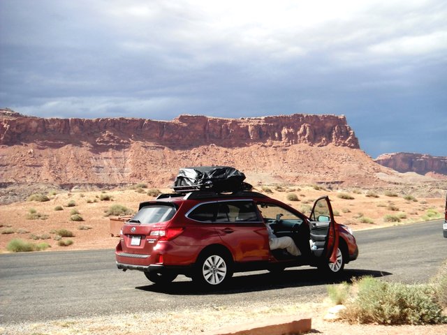
Stong Subaru at Hite Overlook (Lake Powell)
|
|
The logistics for the trip were a little different this year as the Nick's and I were in Lynnwood, Mike was in Kennewick, and Will was in Spokane. Since we would be using Mike's Subaru as our main vehicle, we agreed to meet at Mike's home. I picked up the Nicks early in the morning we headed off in my 1985 Camry (The Gray Ghost) making our traditional breakfast stop at the Ellensburg McDonalds. We got to Mike's house and after packing all our gear in his Subaru, and rooftop carrier, the five of us climbed in and off we went. We arrived at the Marble Motel in Tremonton, Utah after dark - truly a long day on the road.
The next day we headed south making a stop in Price for last minute supplies and then lunch in Hanksville. Along the way we took in the view at the Hite Overlook and arrived at our camp at the head of Todie Canyon at the same spot we had used the two years previously.
Note photo takers are given in the titles under the thumbnails: Bill (bm), Mike (ms), Nick M. (nm), Nick T. (nt)
Kickass Trekkers on this trip were: Bill Mooseker, Will Stong, Mike Stong, Nick McMahan, Nick Tuggle
The descriptions under the photo thumbnails in the album sometimes contain links to maps or additional information. These are identified by "Blue” text for links. I've also inserted links to Google Maps to show where certain photos in the album were taken or to locate features shown in the photos. Click on the link, close the sidebar, and choose satellite view. Basically, you can then zoom in and out using the mouse wheel or drag the map by clicking and holding.
For panoramic photos, I would recommend clicking on the thumbnail photo to enlarge. View at original size for most detail. The thumbnails do not do justice to petroglyphs and pictographs, so I would recommend enlarging them as well. Please take the time to view the many videos to better experience what it was like to be there.
|
Troop 24 Kickass Trekkers Backpacking Trip
-Cascade Bill Mooseker
|
| 792 Visits, 50 Images, Shared Album |
|
| 2.
2017 Grand Gulch - Day 1 (May 22, 2017)
|
|
Grand Gulch 2017
Day 1 - May 22
Gov't Trailhead to Pollys Canyon
Day hike to Big Man Panel
|
|
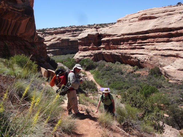
Mike and Nick T. Descending Into Grand Gulch on the Gov't Trail
|
|
The plans for Day 1 were not too ambitious as we had to pick up our permit; watch the mandatory video; shuttle the gear, the Nicks and Will to the Gov't Trail trailhead; drive from there to Collins Canyon trailhead to park the Subaru and meet our shuttle who would return us to the Gov't Trailhead.
After arriving at the Kane RS at 7:45 AM, it wasn't until shortly after noon that Mike and I finally started down the trail. Our plan was to camp at the mouth of Pollys Canyon and then day hike up to the Big Man Panel.
Note photo takers are given in the titles under the thumbnails: Bill (bm), Mike (ms), Nick M. (nm), Nick T. (nt)
Kickass Trekkers on this trip were: Bill Mooseker, Will Stong, Mike Stong, Nick McMahan, Nick Tuggle
The descriptions under the photo thumbnails in the album sometimes contain links to maps or additional information. These are identified by "Blue” text for links. I've also inserted links to Google Maps to show where certain photos in the album were taken or to locate features shown in the photos. Click on the link, close the sidebar, and choose satellite view. Basically, you can then zoom in and out using the mouse wheel or drag the map by clicking and holding.
For panoramic photos, I would recommend clicking on the thumbnail photo to enlarge. View at original size for most detail. The thumbnails do not do justice to petroglyphs and pictographs, so I would recommend enlarging them as well. Please take the time to view the many videos to better experience what it was like to be there.
|
Troop 24 Kickass Trekkers Backpacking Trip
-Cascade Bill Mooseker
|
| 1025 Visits, 78 Images, Shared Album |
|
| 3.
2017 Grand Gulch - Day 2 (May 23, 2017)
|
|
Grand Gulch 2017
Day 2 - May 23
Pollys Canyon to Big Pouroff
Slide Ruin
Fortress Ruin
Railroad Panel
|
|
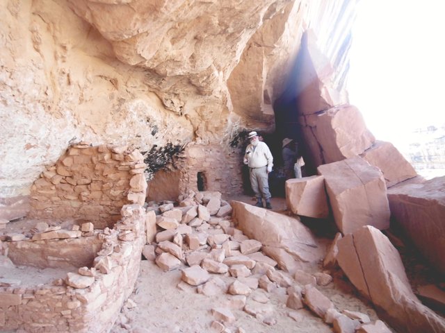
Exploring the Fortress Ruin
|
|
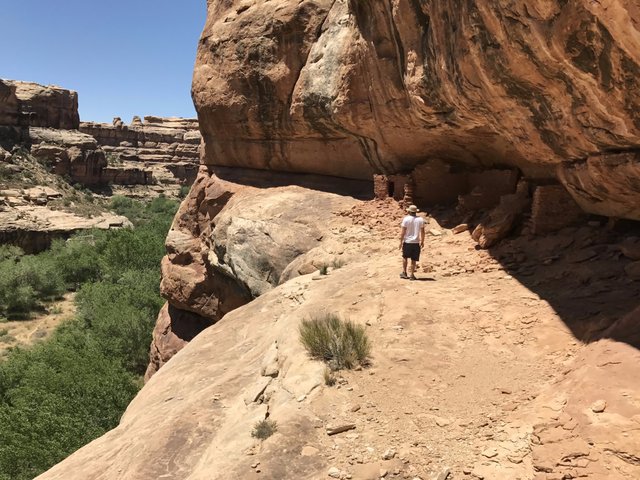
We didn't go as far as we planned on Day 2 because of the water situation and the heat. In 2000, we hiked from Pollys Canyon to the Bannister Ruin in one day, but only made it to the Big Pouroff on this trip. However, the more leisurely pace allowed more time for exploration and sidetrips
What a day it was. Many ruins to see and explore, including the fantastic Fortress Ruin. Also amazing was the Railroad Panel, which we had missed in 2000.
Note photo takers are given in the titles under the thumbnails: Bill (bm), Mike (ms), Nick M. (nm), Nick T. (nt)
Kickass Trekkers on this trip were: Bill Mooseker, Will Stong, Mike Stong, Nick McMahan, Nick Tuggle
The descriptions under the photo thumbnails in the album sometimes contain links to maps or additional information. These are identified by "Blue” text for links. I've also inserted links to Google Maps to show where certain photos in the album were taken or to locate features shown in the photos. Click on the link, close the sidebar, and choose satellite view. Basically, you can then zoom in and out using the mouse wheel or drag the map by clicking and holding.
For panoramic photos, I would recommend clicking on the thumbnail photo to enlarge. View at original size for most detail. The thumbnails do not do justice to petroglyphs and pictographs, so I would recommend enlarging them as well. Please take the time to view the many videos to better experience what it was like to be there.
|
Troop 24 Kickass Trekkers Backpacking Trip
-Cascade Bill Mooseker
|
| 1392 Visits, 206 Images, Shared Album |
|
| 4.
2017 Grand Gulch - Day 3 (May 24, 2017)
|
|
Grand Gulch 2017
Day 3 - May 24
Big Pouroff to Bannister Ruin
Sidetrip up Deer Canyon
Misc. Ruins
Bannister Ruin
|
|
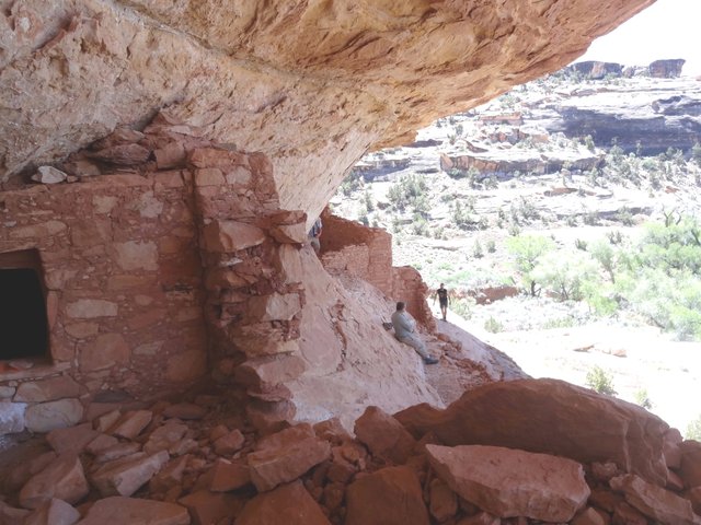
Nick T. Exploring Ruin
|
|
Leaving our Camp at the Big Pouroff, we headed down canyon in the cool of the morning, often in the shade. When we got to the mouth of Deer Canyon, we stashed our packs and headed up the north fork of Deer. This fork of Deer is very pleasant, with a nice spring at the end. The Nicks did some exploring of the upper reaches.
When we got back to our packs, we met another group taking a break. They were also heading down canyon - the first people we had seen since our first day. We headed out, taking advantage of what shade we could find as the temperature was creeping up.
The Nicks spotted some ruins high up on the canyon walls and broke off to explore them. Will, Mike, and I continued on down canyon. It wasn't long until we came to Bannister Ruin. I would have kept on going and missed it if Mike hadn't put his hiking stick in the path, causing me to look up and see the ruin. In 2000 there was a great camp here in a grove of huge cottonwoods, but now most of them had died and the ground was littered a jumble of dead branches with no shade. However, we found an adequate spot nearby and parked ourselves in the shade and had lunch. Later on we went over and explored the ruins.
Note photo takers are given in the titles under the thumbnails: Bill (bm), Mike (ms), Nick M. (nm), Nick T. (nt)
Kickass Trekkers on this trip were: Bill Mooseker, Will Stong, Mike Stong, Nick McMahan, Nick Tuggle
The descriptions under the photo thumbnails in the album sometimes contain links to maps or additional information. These are identified by "Blue” text for links. I've also inserted links to Google Maps to show where certain photos in the album were taken or to locate features shown in the photos. Click on the link, close the sidebar, and choose satellite view. Basically, you can then zoom in and out using the mouse wheel or drag the map by clicking and holding.
For panoramic photos, I would recommend clicking on the thumbnail photo to enlarge. View at original size for most detail. The thumbnails do not do justice to petroglyphs and pictographs, so I would recommend enlarging them as well. Please take the time to view the many videos to better experience what it was like to be there.
|
Troop 24 Kickass Trekkers Backpacking Trip
-Cascade Bill Mooseker
|
| 1075 Visits, 121 Images, Shared Album |
|
| 5.
2017 Grand Gulch - Day 4 (May 25, 2017)
|
|
Grand Gulch 2017
Day 4 - May 25
Bannister Ruin to The Narrows
Rincon Pictographs
The Narrows
Holding Hands (Harvey) Panel
|
|
Bill M. Hiking Down Grand Gulch
|
|
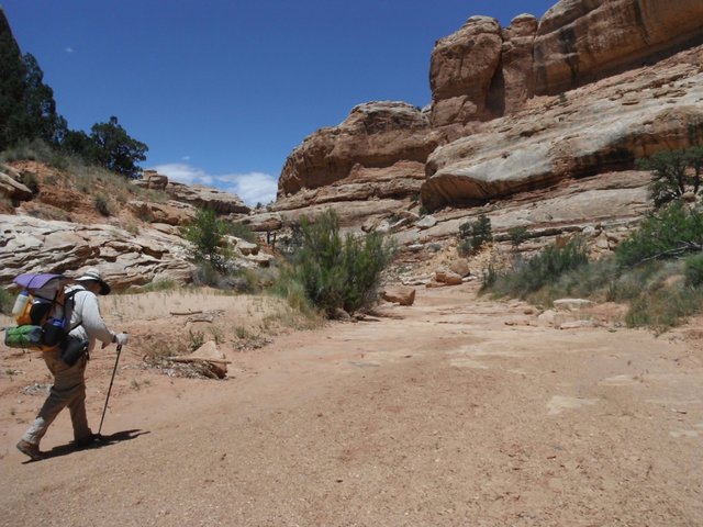
Our goal for Day 4 was to hike to the Narrows, which is a relatively short hike. While there aren't many spectacular ruins along this stretch of the Gulch, it is very scenic and pleasant hiking.
Even though the day's hike was short, the relaxed pace allowed time for exploration and visiting several pictograph panels along the way. By afternoon it was very hot, and the Narrows offered a shady and breezy spot to escape the heat.
Unlike our last visit to the Narrows (2006), water was very scarce and we were lucky enough to find a few rock pockets near our camp that still had water. The Nicks thankfully carried the heavy 5 gal jugs up the hill to our camp on the rocks overlooking the Narrows.
Our last camp featured an unbelievable view of the night sky before the chill forced us into our sleeping bags.
Note photo takers are given in the titles under the thumbnails: Bill (bm), Mike (ms), Nick M. (nm), Nick T. (nt)
Kickass Trekkers on this trip were: Bill Mooseker, Will Stong, Mike Stong, Nick McMahan, Nick Tuggle
The descriptions under the photo thumbnails in the album sometimes contain links to maps or additional information. These are identified by "Blue” text for links. I've also inserted links to Google Maps to show where certain photos in the album were taken or to locate features shown in the photos. Click on the link, close the sidebar, and choose satellite view. Basically, you can then zoom in and out using the mouse wheel or drag the map by clicking and holding.
For panoramic photos, I would recommend clicking on the thumbnail photo to enlarge. View at original size for most detail. The thumbnails do not do justice to petroglyphs and pictographs, so I would recommend enlarging them as well. Please take the time to view the many videos to better experience what it was like to be there.
|
Troop 24 Kickass Trekkers Backpacking Trip
-Cascade Bill Mooseker
|
| 825 Visits, 115 Images, Shared Album |
|
| 6.
2017 Grand Gulch - Day 5 (May 26, 2017)
|
|
Grand Gulch 2017
Day 5 - May 26
The Narrows to Collins Spring Trailhead
Collins Canyon
Cowboy Camp
Salvation Knoll
|
Nick M. Carrying the Old Man's Pack Up The Last Leg
Of Collins Canyon
|
|
On our last day, we broke camp very early and headed back up the Gulch a short ways to begin our climb out via Collins Canyon. The hike up Collins is very pleasant and scenic. Even though I was the first one out of camp the Nicks and the Stongs soon overtook me and left me in the dust. It didn't help that I made the wrong turn not once but twice as I mistakenly headed up a side canyon and then missed the trail around a pouroff.
Along with the scenery, the trip is memorable for an old (early 20th century) Cowboy camp above a massive pouroff that provides an interesting glimpse of the modern history of the canyon. The pouroff is skirted by a constructed cattle trail and signals that we are not far from the trailhead. At the top of the pouroff, the canyon walls no longer tower over you and you realize that your hike will soon be over.
It's a relief to change clothes and wash up at the trailhead. I even had a fairly cold diet coke in the cooler. After packing up all the gear we headed out for our long trip home. Our last scenic stop was to climb the "Salvation Knoll" which played a significant role in the historic Hole in the Rock pioneer expedition. Then it was on to Blanding, for our first non freeze dried food in 5 days.
Note photo takers are given in the titles under the thumbnails: Bill (bm), Mike (ms), Nick M. (nm), Nick T. (nt)
Kickass Trekkers on this trip were: Bill Mooseker, Will Stong, Mike Stong, Nick McMahan, Nick Tuggle
The descriptions under the photo thumbnails in the album sometimes contain links to maps or additional information. These are identified by "Blue” text for links. I've also inserted links to Google Maps to show where certain photos in the album were taken or to locate features shown in the photos. Click on the link, close the sidebar, and choose satellite view. Basically, you can then zoom in and out using the mouse wheel or drag the map by clicking and holding.
For panoramic photos, I would recommend clicking on the thumbnail photo to enlarge. View at original size for most detail. The thumbnails do not do justice to petroglyphs and pictographs, so I would recommend enlarging them as well. Please take the time to view the many videos to better experience what it was like to be there.
|
Troop 24 Kickass Trekkers Backpacking Trip
-Cascade Bill Mooseker
|
| 649 Visits, 69 Images, Shared Album |
|
| 7.
Anazasi Moccasins Found (May 2017)
|
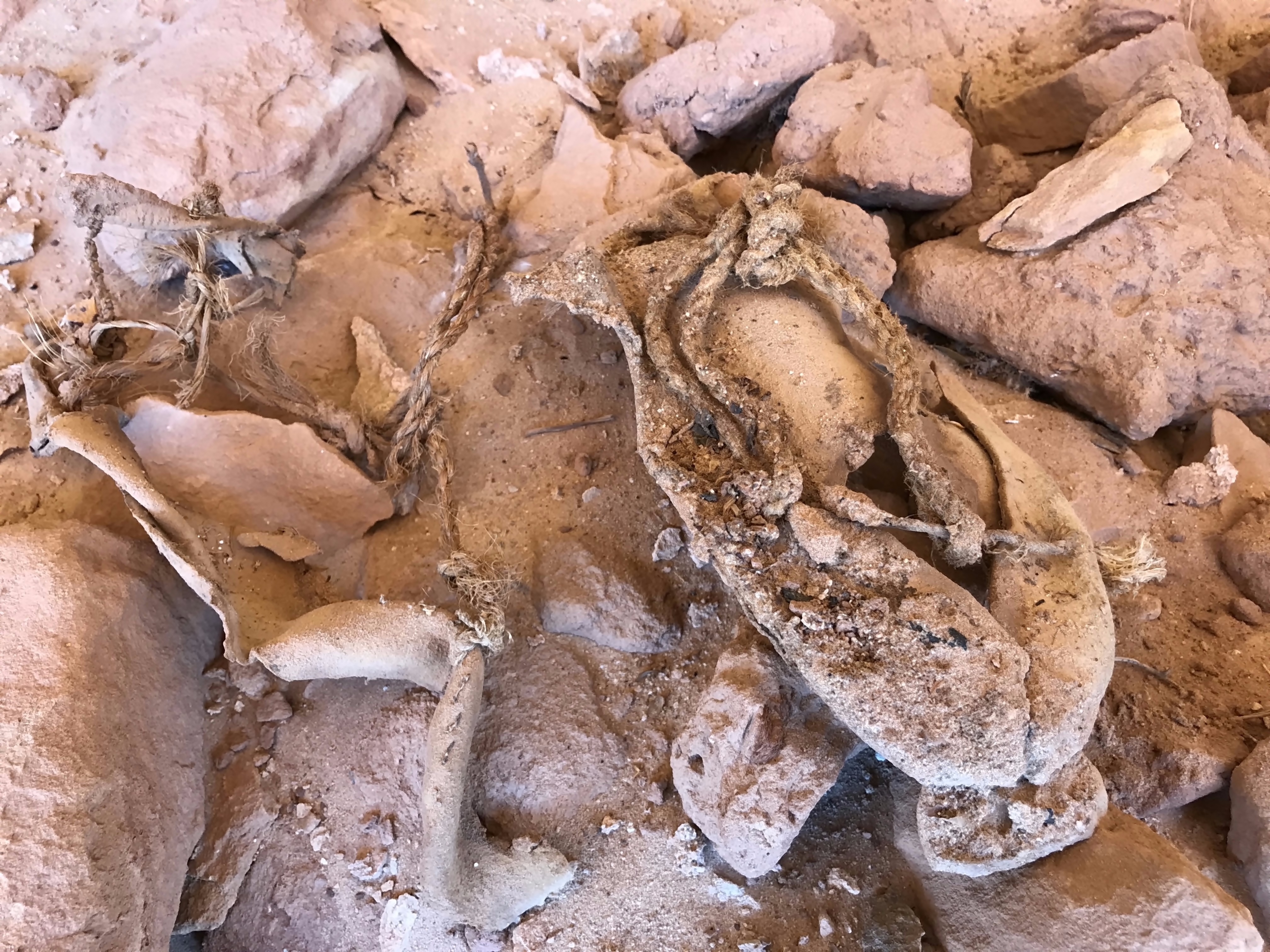
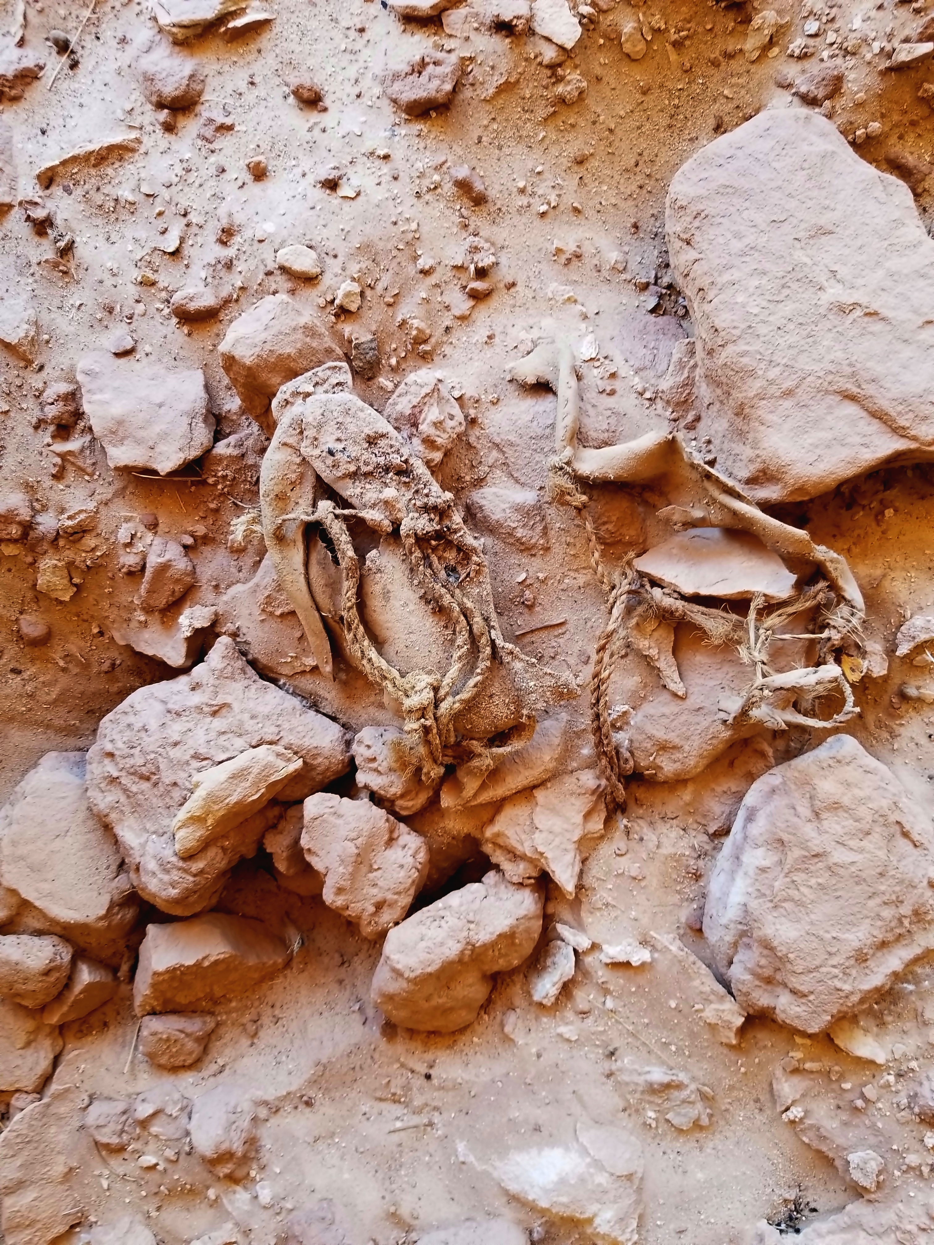
On one of their explorations of the Grand Gulch on our trip, the Nicks (Nick McMahan and Nick Tuggle) stumbled on a pair of Anazasi moccasins in an almost inaccessible alcove (note: the Nicks are climbers). The photos below show the moccasins in situ. Their location was reported to the BLM, who reported back that they were probably for a child as the adults normally wore sandals or went barefoot. The BLM also stated that they would have been made sometime between 800-1200 AD.
One of the moccasins ins in pretty good shape, but the other has seen better days. If you click on the photos below, an enlarged image will be shown. You can then click on the image agein to view the image at the highest resolution. If you do this you can see that one of the rope laces has been braided into an "eye" and has a short length of cord with an enlarged end passing through it, possibly to keep the cord from going past the "eye". On the other moccasin, you can see the stitching quite clearly.
|
|
|
|
Moccasin Photo 1
|
|
|
|
|
|
Moccasin Photo 2
|
Troop 24 Kickass Trekkers: "The High Adventure Troop" Alumni Backpacking Trip
-Cascade Bill Mooseker
|
|
| |