Gov't Trailhead to Pollys Canyon
Day hike to Big Man Panel
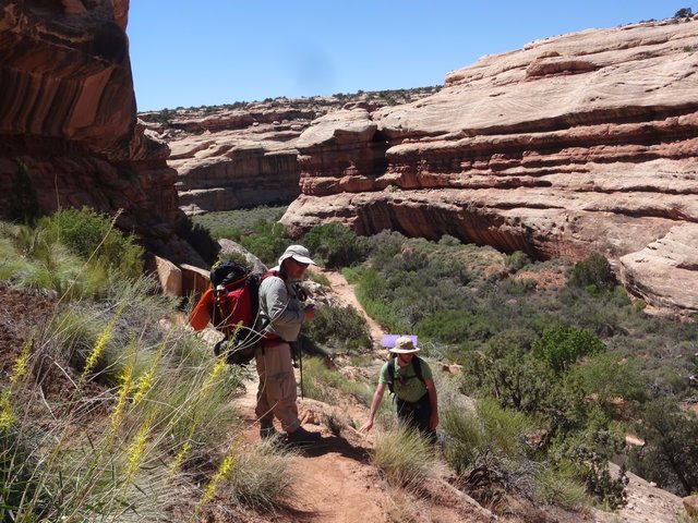
Mike and Nick T. Descending Into Grand Gulch on the Gov't Trail
The plans for Day 1 were not too ambitious as we had to pick up our permit; watch the mandatory video; shuttle the gear, the Nicks and Will to the Gov't Trail trailhead; drive from there to Collins Canyon trailhead to park the Subaru and meet our shuttle who would return us to the Gov't Trailhead.
After arriving at the Kane RS at 7:45 AM, it wasn't until shortly after noon that Mike and I finally started down the trail. Our plan was to camp at the mouth of Pollys Canyon and then day hike up to the Big Man Panel.
Note photo takers are given in the titles under the thumbnails: Bill (bm), Mike (ms), Nick M. (nm), Nick T. (nt)
Kickass Trekkers on this trip were: Bill Mooseker, Will Stong, Mike Stong, Nick McMahan, Nick Tuggle
The descriptions under the photo thumbnails in the album sometimes contain links to maps or additional information. These are identified by "Blue” text for links. I've also inserted links to Google Maps to show where certain photos in the album were taken or to locate features shown in the photos. Click on the link, close the sidebar, and choose satellite view. Basically, you can then zoom in and out using the mouse wheel or drag the map by clicking and holding.
For panoramic photos, I would recommend clicking on the thumbnail photo to enlarge. View at original size for most detail. The thumbnails do not do justice to petroglyphs and pictographs, so I would recommend enlarging them as well. Please take the time to view the many videos to better experience what it was like to be there.
Troop 24 Kickass Trekkers Backpacking Trip
-Cascade Bill Mooseker
Date(s): May 22, 2017. Album by Cascade Bill. 1 - 78 of 78 Total. 323 Visits.
enlarge 335KB, 995x1024 1 picsnvids
To get the plugin just Google "videolan" or CLICK HERE FOR DOWNLOAD for Windows. There is a MAC version as well. Disable the Quicktime plugin if you use Videolan. To view fullscreen videos click the icon on the top right of the video when it starts playing.
If you want to save photos to your computer, click the box under the thumbnails of the photos you want to download. Then click the "Download" button at the top of the album. Pick the size you'd like to download (Original is best)and the photos will be downloaded to a folder of your choice.
enlarge 115KB, 1024x768 2 05-22 07-23-58 - bm DSC01855 The Kane Gulch Ranger Station is open only from 8 AM till noon for getting your backcountry permit. When we got there at 7:45, we were dismayed to find a large crowd gathered at the door because we were under the gun to meet our shuttle at the Collins Canyon trailhead at 10 AM. Fortunately, the ranger asked if anyone had reservations for their permit. We were the only ones who had so we got to go in first.
enlarge 144KB, 1024x768 3 05-22 08-29-17 - ms DSCF4830 Here we are at the Government Trailhead - Bill showing Nick T. and Nick M. the route on his maps. After getting our permit and watching the mandatory video (for the 3rd time), we hit the road for our starting point - the Government Trail. It takes about an hour and when we got there we dropped off all our packs along with Will and the two Nicks. Mike and I then headed off to meet our shuttle at Collins Canyon.
enlarge 192KB, 1024x768 4 05-22 08-29-35 - ms DSCF4831 Getting the gear stowed away - you can see the stock pond beyond. This is where we ended out 2016 hike as shown HERE.
enlarge 203KB, 1024x768 5 05-22 08-31-09 - ms DSCF4832 The Subaru emptied of its load.
enlarge 63.63MB, 1152x648 Download MPEG4 6 05-22 08-35a ws.mp4 VIDEO - Click Photo to View. "Last Words"
enlarge 118KB, 1024x768 7 05-22 08-42-50 - ms DSCF4835 Heading back up the road. The last half mile of the Gov't Trail road is pretty rough as you can see here.
enlarge 111KB, 1024x768 8 05-22 08-44-03 - ms DSCF4838 This is a road?
enlarge 146KB, 1024x768 9 05-22 08-46-14 - ms DSCF4841 Over the rocks.
enlarge 115KB, 1024x768 10 05-22 09-16-27 - bm DSC01856 Back on UT261, the Bears Ears in the distance.
For a map of the drive from Gov't Trail to Collins Canyon CLICK HERE
enlarge 138KB, 1024x768 11 05-22 09-17-07 - bm DSC01857 Another view of the Bears Ears. We drove through them in 2012 on our trip to Dark Canyon. For a photo album of that trip CLICK HERE
enlarge 77.98MB, 1152x648 Download MPEG4 12 05-22 09-26 ws 1.mp4 VIDEO - Click Photo to View. 360 view from Government trail across Cedar Mesa. As we were driving to meet our shuttle, Will and the Nicks headed out on the trail.
enlarge 306KB, 1024x768 13 05-22 09-32-32 - nt IMG 0034 Meanwhile back on the trail, Nick T. got a shot of this cactus in bloom.
enlarge 108KB, 1024x768 14 05-22 09-33-17 - nm IMG 2063 Nick M.'s photo of this Prickly Pear cactus bloom.
enlarge 178KB, 1024x768 15 05-22 09-34-30 - bm DSC01862 Bill's photo (much later) of another Prickly Pear cactus bloom along the Gov't Trail.
enlarge 153KB, 1152x478 16 05-22 09-55-13 - nm IMG 2068 Panoramic shot of Grand Gulch at Polly's Island from the rim.
enlarge 219KB, 1024x768 17 05-22 10-02-07 - nm IMG 2072 Looking down into Polly's Canyon.
enlarge 56.06MB, 1152x648 Download MPEG4 18 05-22 09-55 nm.mp4 VIDEO - Click Photo to View. Video showing 360 degree view of Grand Gulch from the rim where the Gov't Trail (note post in video) begins its descent into the canyon.
enlarge 105KB, 1152x312 19 05-22 10-05-22 - nm IMG 2075 Panoramic shot of Grand Gulch, Polly's Island, and Polly's Canyon. Our camp was in the cottonwoods where the canyons come together - L to R: Grand Gulch downcanyon, Rincon around Polly's Island, Grand Gulch up canyon, and Polly's Canyon.
enlarge 201KB, 1024x768 20 05-22 10-12-02 - nt IMG 0036 Looking down into Grand Gulch - the trail leaves the rim here to switchback down to the wash.
enlarge 129KB, 1024x768 21 05-22 10-14-51 - ms DSCF4850 The Subaru at Collins Canyon Trailhead. We made it to the trailhead at 5 min after 10 to meet our shuttle, which was waiting for us with a 12 passenger van instead of the jeep we thought was going to be there. The van was a little slower than the jeep would have been but we didn't have to pay the extra.
We enjoyed the ride and the conversation with the Four Corners Adventures driver,Lane Palmer. While Lane was waiting for us he had been braiding a yucca cord. When we got back to the Gov't Trail, he taught Mike how to do it.
enlarge 102KB, 768x1024 22 05-22 10-19-22 - nt IMG 0037 While Mike and I were dropping the Subaru off at Collins the Two Nicks were fooling around with the "Fisheye" lens at the rim.
enlarge 194KB, 1024x768 23 05-22 10-34-02 - nm IMG 2085 Nick T. and Will heading down from the rim.
enlarge 144KB, 1024x768 24 05-22 12-16-09 - ms DSCF4851 Finally on the trail almost 4 hours after we dropped of the gear. That sure is a long shuttle. In 2000, they were more lax with the permits as the volunteers at the ranger station (a trailer) usually were open in the afternoon or put the permits on a bulletin board outside the trailer if they weren't there. We got our permits the afternoon before and were able to shuttle the cars that same day we got to Cedar Mesa and get an early start the next morning. To be fair, we were going down Bullet Canyon which is much closer than the Gov't trail.
enlarge 190KB, 1024x768 25 05-22 12-16-25 - bm DSC01859 Mike - mountains in the background are "The Windgate" on the left and Moss Back Butte on the right
enlarge 149KB, 1024x768 26 05-22 12-16-27 - ms DSCF4853 On the mesa top you can't tell that there are deep canyons there.
enlarge 105KB, 1024x768 27 05-22 12-36-53 - bm DSC01860 The two Nicks came all the way back after climbing back up to the rim and most of the way to the trailhead so they could carry my pack for me. Nick M. carried it to the rim and Nick T from the rim to our camp. Bless them for making it easier on an old man.
enlarge 52.11MB, 1152x648 Download MPEG4 28 05-22 12-37 bm.mp4 VIDEO - Click Photo to View.
The Nicks forging ahead with my pack along the trail to the rim. At the end of the video, you can see the Bears Ears in the distance.
enlarge 162.70MB, 1152x648 Download MPEG4 30 05-22 13-30 bm.mp4 VIDEO - Click Photo to View. Approaching the rim and then descending down switchbacks along the trail.
enlarge 238KB, 1152x647 31 05-22 13-22-07 - bm DSC01864 Nick Tuggle, Nick McMahan, and Mike Stong at the canyon rim - you can see the post (to the right) that used to have the trail signs attached: See Here in 2002
enlarge 240KB, 1024x768 32 05-22 13-23-42 - bm DSC01865 Looking down into Grand Gulch at Polly's Island.
enlarge 193KB, 1024x768 33 05-22 13-24-10 - bm DSC01866 Looking down canyon from the rim.
enlarge 179KB, 1024x768 34 05-22 13-29-05 - bm DSC01867 Following the trail down.
enlarge 118KB, 768x1024 35 05-22 13-42-17 - nm IMG 2089 While Nick Tuggle, Mike, and I headed down the trail, Nick McMahan did a little scrambling and found this crack to squeeze through.
enlarge 98KB, 1152x522 36 05-22 13-42-50 - nm IMG 2090 View of the "crack"
enlarge 142KB, 768x1024 37 05-22 13-43-18 - nm IMG 2086 Nick M. also found this petroglyph panel - note the 4 Kokopellis which are pretty rare in Grand Gulch (from my visits anyway). (Click thumbnail to enlarge photo)
enlarge 175KB, 1024x768 38 05-22 13-46-15 - ms DSCF4854 Almost to the bottom and we can see that there is a lot less water here than there was a year ago - Same view in 2016
enlarge 234KB, 1024x768 39 05-22 13-46-24 - ms DSCF4855 Nick T. rounding a switchback.
enlarge 247KB, 1024x768 40 05-22 13-46-37 - bm DSC01870 Mike and Nick - couple more switchbacks to go to the bottom.
enlarge 187KB, 1024x768 41 05-22 13-46-39 - ms DSCF4856 Nick Tuggle carrying my backpack.
enlarge 143KB, 1024x768 42 05-22 13-46-40 - ms DSCF4857 Nick pointing to ruins under the rim of Polly's Island.
enlarge 140KB, 1024x768 43 05-22 13-46-47 - bm DSC01869 1 Polly's Island ruins that Nick was pointing out.
enlarge 139KB, 1024x768 44 05-22 13-46-48 - ms DSCF4858 Bill taking photo of Polly's Island ruins.
enlarge 185KB, 1152x441 45 05-22 15-23-02 - nm IMG 2097 Panoramic view of our camp at the mouth of Polly's Canyon.
enlarge 33.12MB, 1152x648 Download MPEG4 46 05-22 15-43 nm.mp4 VIDEO - Click Photo to View. After we had lunch, everyone but me Hiked up the canyon to see the Big Man panel.
enlarge 205KB, 1024x768 47 05-22 15-36-52 - nt IMG 0039 Nick M. doing a little off trail exploring up canyon from Pollys Canyon.
enlarge 333KB, 1024x768 48 05-22 15-47-45 - nm IMG 2104 Hiking up the wash in the late afternoon.
enlarge 217KB, 768x1024 49 05-22 15-48-20 - nm IMG 2105 The wash skirts the canyon wall.
enlarge 279KB, 1024x768 50 05-22 15-48-37 - nm IMG 2106 Desert "varnish" stains the red rock of the canyon wall.
enlarge 86.34MB, 1152x648 Download MPEG4 51 05-22 15-52 ws.mp4 VIDEO - Click Photo to View. Heading up canyon from Pollys Island to the Big Man Panel.
enlarge 115KB, 1152x355 52 05-22 15-54-36 - nm IMG 2109 Panoramic view of canyon from ledge above wash.
enlarge 180KB, 1024x768 60 05-22 17-20-25 - nt IMG 0047 Nick M and Mike at the Big Man Panel.
enlarge 152KB, 1024x768 61 05-22 17-20-57 - nt IMG 0048 Nick M at Big Man panel.
enlarge 147KB, 1024x768 62 05-22 17-21-39 - nt IMG 0050 "Sometimes there's a man, well... he's the man for his time and place". - Nick McMahan.
enlarge 147KB, 1024x768 63 05-22 17-21-48 - ms DSCF4865 The two Nicks inspect the panel.
enlarge 142KB, 1024x768 64 05-22 17-21-49 - ms DSCF4866
enlarge 170.36MB, 1152x648 Download MPEG4 65 05-22 17-15 ws.mp4 VIDEO - Click Photo to View. Video of the Big Man Panel.
enlarge 88KB, 768x1024 66 05-22 17-22-30 - ms DSCF4863 The "Big Man".
enlarge 143KB, 1024x768 67 05-22 17-22-32 - nt IMG 0054 Overview of panel.
enlarge 181KB, 768x1024 68 05-22 17-22-54 - ms DSCF4864 Secondary figures, hand prints, and bearpaw on the panel.
enlarge 296KB, 768x1024 69 05-22 17-27-21 - nt IMG 0051 The late afternoon sun emphasizes the combination of petroglyph and pictograph techniques in the figure.
enlarge 128KB, 768x1024 70 05-22 17-28-45 - nt IMG 0052 Torso of the Big Man.
enlarge 141KB, 1024x768 71 05-22 17-29-02 - nt IMG 0053 Details of the Big Man's head.
enlarge 145KB, 1007x1024 72 05-22 17-43-03 - ms DSCF4868 Nick McMahan climbs to vantage point located HERE.
enlarge 114KB, 768x1024 73 05-22 17-43-10 - ms DSCF4869 Nick at vantage point at mouth of small side canyon.
enlarge 121.30MB, 1152x648 Download MPEG4 74 05-22 17-42 nm.mp4 VIDEO - Click Photo to View. Nick M's video from vantage point above canyon.
enlarge 241KB, 1024x768 75 05-22 17-45-43 - nm IMG 2151 Prickly Pear cactus with yellow blooms growing out of the rocks.