Kickass III - August 2012
Day 1: Phelps Cr to Spider Meadow
Day 2: Spider Meadow to Lyman Lake
Day 3: Lyman Lake to Image Lake
Day 4: Image Lake to Miner's Creek
Day 5: Miner's Creek to Buck Creek Basin
Day 6: Buck Cr Basin to Massie Lake
Day 7: Massie Lake to Trinity
Heading Down Snowfield to Lyman Basin
Attendees: Bill Mooseker, Fred Stong, Mike Stong, Shelby Stong, Jill Stong, Roger Shively, Danny Stallings.
This photo album documents a week long backpacking trip by the Troop 24 Kickass Trekkers in August 2012. In fact it was basically this hike in 1997 that put the "Kickass" in our name, when Bill Peckinpaugh made the observation that this hike "really kicks your ass!". The 1997 hike was thereafter known as Kickass I.
Originally we had planned to do a trip in the Pasayten, but time constraints and accomodating travel plans ruled that out. This is the fourth time that I've done most of this route (1980, 1983, 1997) and as I've reached the age (69) where I realize that it is the last time, which is kind of sad as this is probably one of the most challenging and scenic trips around.
Normally I've started this route by following the Carne Mountain/ Leroy Creek High Route, but that would have required another night on the trail, and we didn't have that available. Instead we just hiked directly to Spider Meadow (one of my favorite camps) rather than arriving there on the third night. From there the route goes over Spider Gap down to Lyman Lake; from Lyman Lake to Image Lake; Image Lake to Buck Creek Pass;and, finally, retracing the Massie Lake High Route in reverse from our 2001 Kickass II hike, before returning to Trinity via the Chiwawa Basin Trail.
Included in the album are photos by Roger (file names ending in "r"); Jill and Shelby (file names ending in "j");and, Mike Stong (file names ending in "m"). Note that Jill's photos were copied from her Facebook albums and are fairly low resolution.
Troop 24 Kickass Trekkers Backpacking Trip
-Cascade Bill Mooseker
Date(s): 08/26/12-09/01/12. Album by Cascade Bill. 1 - 424 of 424 Total. 2527 Visits.
enlarge 521KB, 1024x1022 1 pic&vids
To get the plugin just Google "videolan" or CLICK HERE FOR DOWNLOAD for Windows. There is a MAC version as well. Disable the Quicktime plugin if you use Videolan.
If you want to save photos to your computer, click the box under the thumbnails of the photos you want to download. Then click the "Download" button at the top of the album. Pick the size you'd like to download (Original is best)and the photos will be downloaded to a folder of your choice.
enlarge 446KB, 791x1024 2 day1-1 Route of our First day of Hiking. View at "Original Size" for best detail.
enlarge 456KB, 791x1024 3 day1-2 Continuation of our first day on the trail. View at "Original Size" for best detail.
enlarge 49KB, 723x1024 4 Menu2.pdf Menus for our trip.
enlarge 383KB, 1024x768 5 ka2012-001 Danny waiting at the Phelps Creek (Spider Mdw) Trailhead.
enlarge 465KB, 1024x768 6 ka2012-002
Getting ready to head out. It was quite a logistical job to get everyone together. Danny and I came in my old Corolla, having met Roger in Monroe. Roger and I shuttled the cars, leaving Roger's at Trinity. We left half the food/gear in the Corolla for the Stongs who would arrive much later.
enlarge 309KB, 768x1024 7 ka2012-0021m
Jill, Shelby, and Penny at the Phelps Creek Trailhead - Shelby and Jill drove down to SeaTac to pick up Fred who flew in from Arizona. Mike drove from Kenniwick and met the rest of the Stongs at the 59'er Diner. You can see my Corolla to the right.
enlarge 391KB, 1024x768 8 ka2012-003
A little past Leroy Creek, the forest opens up and the trail passes through this lovely meadow.
Our camp is at the lower end of the meadows with it's great view.
enlarge 230KB, 1024x768 12 ka2012-0032r Roger at Spider Meadow.
enlarge 231KB, 1152x648 13 ka2012-0033r
After starting out with blue skies and sun, high clouds gradually blotted out the sun. This view from lower Spider Meadow, just past where the trail emerges from the forest.
enlarge 363KB, 1152x648 14 ka2012-0034r Trail leading to campsites on the west side of Spider Meadow.
My firestarter "Big Momma" that my wife got me at a craft fair in the 80's. I had two, but lost the first at the Suiattle hike in 1994. We used it to light our gas stoves.
Unfortunately, "Big Momma" was left at our Massie Lake campsite. In the intervening years, Mike Stong came up with its replacement, the "Stong Striker"
enlarge 236KB, 1152x648 17 2012-08-26 18-40-46 - DSCF1023m Shelby, Danny, and Fred enjoying the campfire.
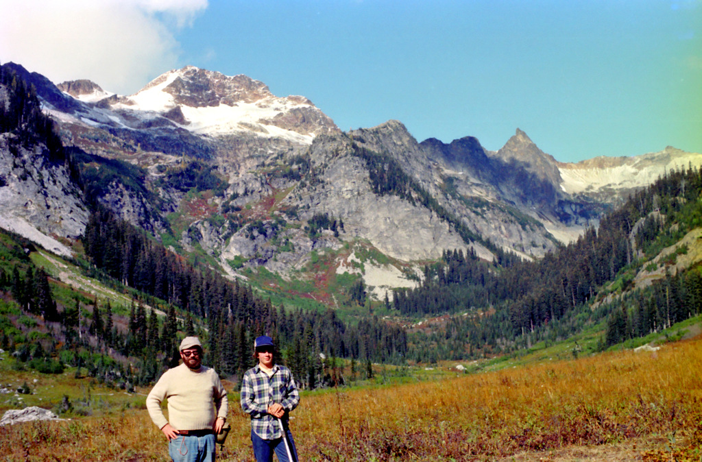
Fred - after many switchbacks the trail is high above the valley below (note the rockface beyond)
enlarge 249KB, 1024x768 37 ka2012-0062r
Climbing up the old miners' trail, we get this view of Spider Meadow below us. If you enlarge the photo to original size, you can see out first night's campsite at the edge of the meadow next to the forest (Look for the big rock).
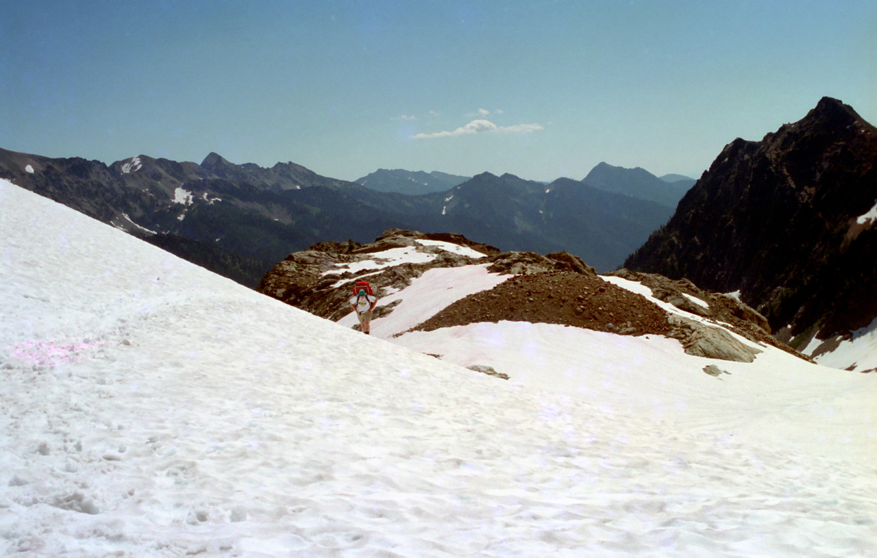
The trail deposits the hiker on a bench with a grand view of Spider Meadow below. There is room for a tent or two at this spot. We took a long break before heading out up the snowfield to Spider Gap.
Fred getting a drink at the base of the snowfield while Penny looks on.
enlarge 279KB, 1152x648 46 2012-08-27 12-14-44 - DSCF1079m Looking back at our group taking their break.
enlarge 46.93MB, 1152x648 Download MPEG4 47 ka002 1280.mp4 VIDEO - Click Photo to View. Heading out onto the Spider "Glacier" (Really just a snowfield).
enlarge 424KB, 1024x768 48 ka2012-008
Out onto the snowfield - there is a trail that takes you near the top, but I think that going up the snow is a little easier. One year (1994) the snowfield was really pockmarked and unsuitable for travel, so we took the trail.
Looking back down - Penny has just about caught up to Mike with Roger closely behind. Jill and Shelby are next with Fred and Bill bringing up the rear far below.
Looking back (Mike) - Jill & Shelby have almost caught up to Roger. Bill and Fred in the back are just rounding the bend.
enlarge 203KB, 1152x648 60 2012-08-27 12-43-23 - DSCF1100m Telephoto of Bill and Fred
enlarge 128KB, 576x1024 61 2012-08-27 12-43-35 - DSCF1102m Looking back
enlarge 123KB, 576x1024 62 2012-08-27 12-43-42 - DSCF1103m Looking up, Danny and Penny are just hazy dots
enlarge 247KB, 1024x768 63 ka2012-013
Bill on the snowfield - at about the center of the first bend. You can see that the snow was in good shape for climbing - soft, but not too soft.
enlarge 195KB, 1024x768 64 ka2012-014
I've made it around the bend and am looking up the snowfield - the others are making much better time than I am. You can see that the climb is very steep. The extra "dots" are another group that is coming down the snowfield.
enlarge 165KB, 576x1024 65 2012-08-27 13-01-26 - DSCF1105m The other group has just passed me on their way down.
enlarge 205KB, 1024x768 66 ka2012-015
Getting closer to the false summit - you can see Fred's silhouette (and yellow bag) against the blue sky at the center of the photo. You can measure my progress, by comparing the previous photo.
I think this photo was taken about the same time as my previous photo showing Fred at the false summit - Mike and Danny are already on top. Shelby and Jill, followed by Roger, with Fred bringing up the rear. Boy was I slow.
enlarge 264KB, 1152x648 69 2012-08-27 13-21-41 - DSCF1119m Fred comes over the false summit
Telephoto view from Spider Gap: the twin peaks of Sitting Bull Mtn and the much higher Dome Peak in the distance. Cloudy Pass is the low point on the ridge in the foreground.
enlarge 105.21MB, 1152x648 Download MPEG4 87 ka003.1 1280.mp4 VIDEO - Click Photo to View.
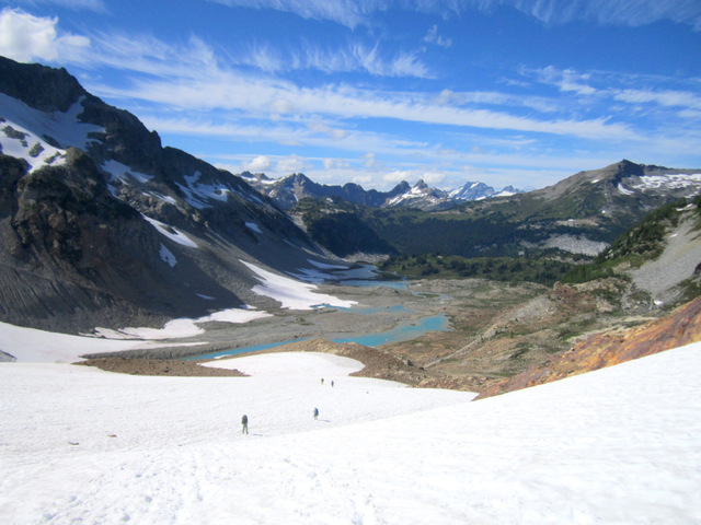
Leaving Spider Gap for the descent into Lyman Basin
enlarge 289KB, 1024x768 88 ka2012-022
Looking down the snowfield on the Lyman side of Spider Gap. You go down this snowfield as far as it goes.
enlarge 213KB, 1152x648 89 2012-08-27 14-16-31 - DSCF1135m Heading down towards Lyman Basin
enlarge 175KB, 576x1024 91 2012-08-27 14-18-08 - DSCF1139m Fred
enlarge 260KB, 1024x768 92 ka2012-023 Fred and Mike on the snowfield.
enlarge 217KB, 1152x648 93 2012-08-27 14-28-26 - DSCF1145m Jill and Fred
enlarge 118KB, 1152x648 94 2012-08-27 14-28-42 - DSCF1146m Bill and Danny
enlarge 252KB, 1024x768 95 ka2012-024 Our group makes its way down the snowfield - Danny, Mike, Jill & Fred
enlarge 253KB, 1024x768 96 ka2012-025 Another view - What's left of the Lyman Glacier is at the left of the photo.
enlarge 291KB, 1024x768 97 ka2012-026
At the end of the snowfield you have to make your way down a steep talus slope.
enlarge 385KB, 1024x768 98 ka2012-027 An Alpine Fireweed I saw on my way down.
enlarge 337KB, 1024x768 99 ka2012-028
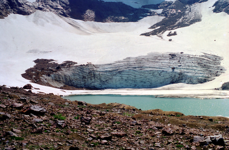
Remnant of the Lyman Glacier - In 1980, the front of the glacier was a massive wall extending as far as the ice covered snow does on the lake. Back then it was a really impressive sight. (Will add link to older photos when I have scanned them in).
enlarge 373KB, 1024x768 100 ka2012-029
If you look closely (or enlarge photo) you can see Mike making his way down the rocky slope. The top of Jill's pack is visible at the far right as well.
enlarge 276KB, 1152x648 101 2012-08-27 14-55-08 - DSCF1153m The lake at the end of the glacier
enlarge 284KB, 1152x648 102 2012-08-27 14-55-01 - DSCF1152m The view of the basin from the talus slope
enlarge 311KB, 1024x768 103 ka2012-030
Looking back on the glacier - a shadow of it's former self - 1997
enlarge 301KB, 1024x768 104 ka2012-03001r
As you make your way down through the rocks, there are various cairns supposedly guiding the way. Shelby followed one down and ended up rolling down a steep slope. A better way is to bear to the right at the end of the snowfield and make your way down to the stream flowing from the snowfield.
enlarge 350KB, 1024x768 105 ka2012-03003r
Can you find the Cairn? I had a bad fall in this area and really skinned my shin.
enlarge 347KB, 1024x768 106 ka2012-03004r Penny - This stuff is even hard for a four legged hiker.
Mike - You can see the snowfield leading down from the Gap above his head. You can also see that there is a lot of talus to make your way down from the snowfield.
enlarge 321KB, 1152x648 117 2012-08-27 16-00-58 - DSCF1160m View looking back towards Spider Gap
enlarge 248KB, 1152x648 118 2012-08-27 16-02-52 - DSCF1163m View of Bonanza Peak on the opposite side of the valley
enlarge 315KB, 1024x768 119 ka2012-033 Looking back - Spider Gap at the left.
enlarge 338KB, 1024x768 120 ka2012-034
A small pond along the way - before the descent to Lyman Lake, you climb this small hill. Jill and Mike are at the top of the hill (enlarge to view).
enlarge 316KB, 1024x768 121 ka2012-035 From the top we get our first view of Lyman Lake.
enlarge 389KB, 1024x768 122 ka2012-036
Cloudy Pass and Cloudy Peak to the left and right above Lyman Lake.
enlarge 79.07MB, 1152x648 Download MPEG4 123 ka004 1280.mp4 VIDEO - Click Photo to View.
Jill and Mike appear on the trail at the left as the camera pans past Cloudy Peak on to the impressive Bonanza Peak.
enlarge 43.34MB, 1152x648 Download MPEG4 124 ka005 1280.mp4 VIDEO - Click Photo to View.
Cloudy Peak and Bonanza Peak- you can see Shelby on the trail. He came back up from the lake to get my pack. At the end of the day I was exhausted and went right to bed (Roger put up my tent) without eating supper.
enlarge 283KB, 576x1024 125 2012-08-27 16-38-53 - DSCF1170m Footlog across Railroad Creek below Lyman Lake
enlarge 334KB, 1152x648 126 2012-08-27 16-39-17 - DSCF1171m Another view
They put the Flamingo at the side of the trail to mark out campsite for the stragglers like me to find
enlarge 384KB, 1024x662 128 day3-1 Map from Camp 2 at Lyman Lake to Glacier Peak Mines on the Miner's Ridge Trail. View at "Original Size" for best detail.
enlarge 361KB, 1024x768 129 ka2012-037 Day 3: Getting ready to leave in the morning. We stayed at a camp near the outlet of Lyman Lake.
enlarge 401KB, 1024x768 130 ka2012-038 Mike and Penny ready to go.
enlarge 220KB, 1024x768 131 ka2012-039 The weather had changed - it was cloudy and cool as this photo of Lyman Lake shows.
enlarge 439KB, 1024x768 132 ka2012-040 Railroad Creek flowing out of Lyman Lake.
enlarge 478KB, 1024x768 133 ka2012-041 A little stream along the way up to Cloudy Pass.
enlarge 537KB, 1152x648 134 2012-08-28 10-06-47 - DSCF1182m A "weeping" spring along the trail supports a wide range of vegetation
enlarge 213KB, 576x1024 135 2012-08-28 10-19-59 - DSCF1185m Fred along the trail to Cloudy Pass
enlarge 65.11MB, 1152x648 Download MPEG4 145 ka006 1280.mp4 VIDEO - Click Photo to View.
We took a break where the trail breaks out of the forest below Cloudy Pass. We didn't want to break at the pass as we thought it would be windy and cold.
enlarge 242KB, 1024x768 146 ka2012-0413r View of the meadows below Cloudy Pass.
enlarge 364KB, 1024x768 150 ka2012-042 Mike striding out.
enlarge 272KB, 1024x768 151 ka2012-043
Looking back towards Spider Gap and the Lyman Glacier (telephoto view). You can see the snowfield and the talus covered slope we came down the previous day.
enlarge 247KB, 1024x768 152 ka2012-044 Normal view.
enlarge 173KB, 1152x648 153 2012-08-28 10-59-05 - DSCF1198m Another view
The view down Agnes creek from the Hiker's Alternate -you can see the main trail as it skirts the talus slope.
enlarge 399KB, 1024x768 180 ka2012-054
Taking the "Hiker's Alternate" to Suiattle Pass. This sketchy route saves about 400 feet of descent and then 400 feet of climbing.
enlarge 258KB, 576x1024 181 2012-08-28 11-41-28 - DSCF1233m Shelby, Penny, and Danny strike out ahead
enlarge 221KB, 576x1024 182 2012-08-28 11-43-12 - DSCF1235m Fred gingerly descending the rocky path
enlarge 170KB, 576x1024 183 2012-08-28 11-43-23 - DSCF1237m Fred
enlarge 220KB, 576x1024 184 2012-08-28 11-44-03 - DSCF1238m Jill coming down the same stretch
enlarge 255KB, 576x1024 185 2012-08-28 11-45-07 - DSCF1242m Jill and Fred (head & pack visible) on sketchy switchbacks
enlarge 279KB, 768x1024 186 ka2012-055
You can see the group ahead along the "Hiker's Alternate" - I'm going slow along this stretch. We took a break at Suiattle Pass (low point on the horizon) for lunch.
enlarge 251KB, 1024x768 187 ka2012-056
Looking down Agnes Creek from the Hiker's Alternate. You can see the main trail as it crosses the meadow to the left of center below.
enlarge 378KB, 1024x662 188 day3-2 Day 3: Map from Suiattle Pass to Camp 3 at Image Lake. View at "Original Size" for best detail.
enlarge 248KB, 1152x648 189 2012-08-28 12-00-32 - DSCF1244m Penny at our break at Suiattle Pass
enlarge 228KB, 1152x648 190 2012-08-28 12-20-10 - DSCF1250m Fred laid out all the topo maps for our hike
enlarge 226KB, 576x1024 191 2012-08-28 12-20-14 - DSCF1251m Shelby, Danny, and Fred checking the route
enlarge 385KB, 1152x648 192 2012-08-28 12-27-08 - DSCF1257m Shelby lighting a fire using a non-scout approved method.
We took a break at the site of the proposed "Glacier Peak Mines". There was a lot of old mining equipment and ruined structures left from the explorations in the 1960's
A bitter battle raged over the open pit copper mine that was proposed for this site. More info can be found HERE
enlarge 318KB, 1152x648 200 2012-08-28 14-06-44 - DSCF1282m Hard to tell what this was
In 1983, on my last 50 miler with the "Old-timers" from Troop 24, we camped here. Photo album of the 1983 trip can be found HERE
enlarge 287KB, 1152x648 201 2012-08-28 14-06-13 - DSCF1281m Winter snows left a pile of rubble.
Clouds look increasingly menacing - it is cold and dreary along the trail
enlarge 120KB, 1152x648 206 2012-08-28 15-01-56 - DSCF1296m Mike's photo of an angry sky
enlarge 203KB, 1024x768 207 ka2012-0561r
The "Hiker's Alternate" connects to the main Cascade Crest trail, which we follow down to the Miner's Ridge Trail. We headed out the trail to Image Lake along Miner's Ridge. Here, shrouded in clouds is Glacier Peak (to the right). Note the "foggy" area to the left of Glacier Peak. We saw this again when we hiked over to Buck Cr. Pass. Don't know whether it's dust, fog, or smoke.
enlarge 409KB, 1024x768 208 ka2012-0562r Lupine, Paintbrush, and Bistort are plentiful in the meadows along Miner's Ridge.
enlarge 345KB, 1024x768 209 ka2012-0563r More meadow flowers.
As far as amenities go, this trip featured Kybo's at Spider Meadow, Lyman Lake and this one at the Image Lake Camp area. When there are no clouds, this "Kybo" has the best view of any other Kybo in the cascades as you can sit on the throne and contemplate Glacier Peak just across the valley.
enlarge 271KB, 1152x648 215 2012-08-28 17-36-20 - DSCF1311m Shelby at our troop gear pile and a welcome campfire.
enlarge 166KB, 1152x648 216 2012-08-28 19-55-26 - DSCF1317m Shelby improved the campfire sitting area
enlarge 228KB, 1152x648 217 2012-08-28 19-57-01 - DSCF1324m Unfortunately, we had to do the dishes using headlamps.
enlarge 378KB, 1024x662 218 day 4 Day 4: Map from Image Lake to Camp 4 at Miner's Creek. View at "Original Size" for best detail.
enlarge 298KB, 576x1024 219 2012-08-29 07-43-27 - DSCF1328m Fred firing up the stoves for breakfast.
The camp is out of sight below the lake. Bill is hiking up to the main trail that goes by the lake.
enlarge 262KB, 1152x648 226 2012-08-29 10-24-59 - DSCF1335m Image Lake
enlarge 256KB, 1152x648 227 2012-08-29 10-26-44 - DSCF1337m Another view
enlarge 220KB, 1024x768 228 ka2012-059
Despite the gloom, there were a few patches of blue sky now and then. This one gives a peek-a-boo view of Glacier Peak poking through the clouds. We didn't get a chance to see the reflected view of Glacier Peak in Image Lake this trip, which is also supposed to be one of the 5 best views in the Cascades.
enlarge 160KB, 1152x648 229 2012-08-29 10-28-02 - DSCF1339m Jill & Penny heading back along the main trail along Miner's Ridge.
enlarge 249KB, 1024x768 230 ka2012-061
You can see a tiny bit of Image Lake peeking out between the trees at the center. If you enlarge the photo to Original size, you can see Roger on the trail coming up from the Image Lake camp area.
enlarge 324KB, 1024x768 231 ka2012-062 Penny and Jill have just about caught up with me above Image Lake.
enlarge 251KB, 1024x768 232 ka2012-063 Jill
enlarge 635KB, 1024x768 233 ka2012-064 Meadow flowers on Miner's Ridge.
enlarge 493KB, 1024x768 234 ka2012-065 Another shot.
enlarge 577KB, 1024x768 235 ka2012-066 Paintbrush - vivid red compared to the usual washed out red that is more common.
enlarge 344KB, 1024x768 236 ka2012-067
We sighted a bear just above the timberline below (black dot). We didn't feel threatened, but Shelby had a face to face encounter with it sometime later when he was on the trail.
enlarge 303KB, 1024x768 237 ka2012-068
Telephoto view (digitally enhanced) of the bear. It definitely knew we were there.
enlarge 321KB, 1152x648 247 2012-08-29 12-06-09 - DSCF1351m Crossing the stream from the basin on Plummer's Mtn
enlarge 56.62MB, 1152x648 Download MPEG4 248 ka009 1280.mp4 VIDEO - Click Photo to View.
Fred crossing stream along the Miner's Ridge Trail.
enlarge 469KB, 1024x768 249 ka2012-071
Fred. At this point the sun was breaking through the clouds from time to time
enlarge 387KB, 1024x768 250 ka2012-072 Bill - looking across to Fortress Mtn.
enlarge 397KB, 768x1024 251 ka2012-073
Bill - I remember this stream from our 1997 Kickass I trip. Steve and Charlie were adamant about filtering their water at the beginning of the trip. I told them that where there was little risk if there was nobody camping in the basin, they religiously pumped their water in the morning. Then on the 6th day, I came around the bend to this stream and saw them filling their water bottles directly from the creek. (Note no one got sick after the trip, or on any of our trips).
enlarge 419KB, 1024x768 252 ka2012-074
We stopped for lunch near the junction with the Crest trail. While we were there we saw four more bears high on Plummer Mtn. Our break spot is located Here. The old cabin shown in the following photos is just north of this spot and can be seen on the Google Map.
enlarge 274KB, 1152x648 253 2012-08-29 12-20-32 - DSCF1354m If you enlarge this photo, you can see a bear in the meadow opposite
Near our lunch spot, there is an old cabin in the meadow (you can see it on the Topo map and the Google Map referenced earlier).
enlarge 509KB, 1024x768 255 ka2012-079
Shelby found a pair of old iron bedsteads, which he was contemplating carrying out (we convinced him that that was a bad idea.) Shelby also found a 1950's era Army stretcher and also had to be dissuaded from carrying it out.
enlarge 319KB, 1152x648 256 2012-08-29 13-15-59 - DSCF1365m The bedsteads
After lunch, we headed down the PCT at one of the switchbacks we got this view of cloud shrouded Fortress Mtn.
enlarge 217KB, 1024x768 268 ka2012-080
Heading down the Cascade Crest Trail we take a photo break looking down Miner's Creek.
enlarge 258KB, 1024x768 269 ka2012-081
Bill - The Cascade Crest Trail originally climbed up the ridge to Image Lake and then along Miner's Ridge to Suiattle Pass. This section bypassing Image Lake passes through non scenic Suiattle Pass and the views along Miner's Ridge. Most Crest trail travelers miss both of the best views at Cloudy Pass and Image Lake and just valley pound up Miner's Creek and then down Agnes Creek. Shame on them.
enlarge 221KB, 576x1024 270 2012-08-29 13-48-47 - DSCF1371m PCT medallion on tree along the trail
enlarge 290KB, 768x1024 271 ka2012-082 We found this creeper along the trail. Don't know what it is.
enlarge 390KB, 1024x768 272 ka2012-083 Another view.
enlarge 319KB, 1152x648 274 2012-08-29 15-52-03 - DSCF1387m Footbridge across Miner's Creek
Our original plan was to hike back up the Buck Creek Pass trail and camp at Sheep Camp along the ridge, but we decided to forgo the long climb and camp where the Crest trail crosses Miner's creek.
enlarge 264KB, 576x1024 275 2012-08-29 14-11-41 - DSCF1384m Miner's creek from the footbridge
Here Shelby and Roger are preparing our big dinner, Chili. Originally we just added sausage and cheese. Now there are onions, garlic, garnishes, etc. for quite a gourmet meal.
enlarge 237KB, 1152x648 277 2012-08-29 16-54-24 - DSCF1390m Checking the Chili
enlarge 301KB, 1152x648 278 2012-08-29 17-05-46 - DSCF1392m "Get your bowls!" All the bowls are laid out ready for the chili to be doled out
enlarge 293KB, 1152x648 279 2012-08-29 17-06-00 - DSCF1394m Dishing out the Chili
enlarge 145.38MB, 1152x648 Download MPEG4 280 ka010 1280.mp4 VIDEO - Click Photo to View. Shelby dishes out the Chili
Just after dark, two through hikers (Mexico to Canada) stopped to camp - they had been 165 days on the trail.
enlarge 386KB, 662x1024 288 day5-1 Day 5: Map from Camp 4 to Miner's Creek to Camp 5 at Upper Buck Cr Basin. View at "Original Size" for best detail.
enlarge 281KB, 1152x648 289 2012-08-30 09-06-46 - DSCF1413m Bill and Fred at the junction of the Middle Ridge Trail (to Buck Creek Pass) with the PCT.
enlarge 278KB, 1152x648 290 2012-08-30 09-07-57 - DSCF1415m Wonder if these were the Thru Hikers? Reminds me of an old Pat Boone Song!
enlarge 229KB, 576x1024 291 2012-08-30 09-57-24 - DSCF1420m Along the Middle Ridge trail
enlarge 329KB, 1024x768 292 ka2012-084
Climbing up the Buck Creek Pass trail after climbing through forest, we finally break out into meadows. From the meadows you can look back across to Miner's Ridge and Plummer Mtn. As you can see the weather was great - not a cloud in the sky, quite a change from the previous day.
enlarge 100.01MB, 1152x648 Download MPEG4 293 ka011 1280.mp4 VIDEO - Click Photo to View.
Gurgling brook in the meadows along the Middle Ridge Trail opposite Miner's Ridge.
enlarge 327KB, 1024x768 294 ka2012-085 Looking back down the trail.
enlarge 287KB, 576x1024 295 2012-08-30 10-00-46 - DSCF1422m Fred and Penny
enlarge 204KB, 1152x648 296 2012-08-30 10-01-10 - DSCF1423m Peak along the ridge
enlarge 347KB, 768x1024 297 ka2012-0852r Jill
enlarge 324KB, 1024x768 298 ka2012-086 Near the top - looking back towards Miner's Ridge and Plummer's Mtn.
enlarge 221KB, 1152x648 299 2012-08-30 10-02-01 - DSCF1425m Telephoto of Miner's Ridge east of Image Lake
enlarge 273KB, 1024x768 300 ka2012-087 The end of Miner's Ridge and Western Peaks of the Cascade's beyond.
enlarge 241KB, 576x1024 301 2012-08-30 10-54-12 - DSCF1431m Fred, Jill, Shelby, & Penny - at the top of the ridge
We took a long break where the trail goes over the crest of Middle Ridge. There is a sheepherder's trail that continues up the ridge from here.
In 1997 When we got to the ridge crest, we met "Pink Cheeks" and her companion again. We had planned on going up the ridge to a little basin to camp, but that was where PC and friend were headed so rather than impose a big group on limited camping options, I opted to continue on the Buck Cr Pass trail. This turned out to be a bad decision (no good deed goes unpunished!) in that we had to camp in a crappy camp at Small Creek instead of high up in the meadows. Basically we were pitching our tents in the trail - no one was happy that night.
enlarge 48.34MB, 1152x648 Download MPEG4 303 ka012 1280.mp4 VIDEO - Click Photo to View.
After a stiff climb we reached the top of Middle Ridge, where we took a well earned break.
enlarge 160.70MB, 1152x648 Download MPEG4 304 ka013 1280.mp4 VIDEO - Click Photo to View.
Fred discussing a range of topics from the Troop Gliders in WWII to the Space Shuttle (Why we love him!).
enlarge 134KB, 1152x332 305 2012-08-30 11-07-08 - DSCF1439a m
Looking down at the north side of the Miner's Creek Valley and the Suiattle beyond. The end of Miner's Ridge is at the right and beyond them is snow covered Sulphur Mtn.
Looking down from the ridge you can see the trail we just came up as it emerged from the forest into the meadows.
enlarge 226KB, 1152x648 311 2012-08-30 12-36-09 - DSCF1448m Benchmark 5279 along the trail.
BM is located as shown on the map HERE. Note that the trail shown on the map is not near the BM.
enlarge 276KB, 1024x768 312 ka2012-0871r
After climbing to the top of Middle Ridge (to the right), we drop way down (about 1100') to Small Creek (shown below). Then its another climb up to Buck Cr Pass. Here the trail switchbacks up the side of a steep and hot avalanche slope. (I fired Buckwheat as the pace setter here in 1997 for going too fast).
enlarge 232KB, 576x1024 313 2012-08-30 12-38-54 - DSCF1457m Jill at Small Cr
This sign is at the top of the ridge where the Middle Ridge Tr meets the Buck Cr Pass-Flower Dome Tr.
enlarge 199KB, 1024x768 317 ka2012-0875r
After climbing out of Small Creek we hit the ridge leading to Flower Dome and get the first view of Glacier Peak since leaving the crest of Middle Ridge.
Telephoto view of the Suiattle Glacier and the upper Suiattle River valley
enlarge 139KB, 1152x648 322 2012-08-30 13-34-50 - DSCF1467m Telephoto view of Glacier peak obscured by Flower Dome
enlarge 349KB, 1152x648 323 2012-08-30 13-32-55 - DSCF1462m Above the trail is the meadowed slopes of Helmet Butte
enlarge 210KB, 1024x768 324 ka2012-0876r
Ahead we can see Buck Creek Pass and the distinctive Liberty Cap. If you enlarge the picture, you can see the trail to High Pass switchbacking up Liberty Cap.
Signpost at the Junction of the Buck Cr Pass - Flower Dome Tr with the Trail to Buck Creek Pass (and on to High Pass). This is located HERE. You can see that the topo map location of the trails in the area are not exactly as they are in reality.
Sign for Designated Horse(shit) camps -- I know cause I've had to camp in some of them
enlarge 474KB, 1024x768 337 ka2012-093
We took a short break at Buck Cr Pass before heading back down the Buck Cr Trail.
enlarge 350KB, 1024x768 338 ka2012-0932r
Following the trail down from Buck Creek Pass, we camped in the basin below Pass No Pass. Our camp was pretty cramped, but we found room for all our tents.
enlarge 303KB, 1152x648 339 2012-08-30 16-13-08 - DSCF1499m Roger & Fred setting up camp
enlarge 233KB, 1024x768 340 ka2012-0931r Mike in our crowded camp site.
enlarge 390KB, 768x1024 341 ka2012-0936r Shelby rebuilding the fire ring.
enlarge 351KB, 768x1024 342 ka2012-0937r That's one heavy rock
enlarge 406KB, 768x1024 343 ka2012-0935r Setting it in place
enlarge 401KB, 768x1024 344 ka2012-0934r Way to go Shelby!
enlarge 415KB, 1024x768 366 ka2012-097 Pass No Pass.
enlarge 365KB, 1024x768 367 ka2012-098 There is fairly good trail on this end of the Massie Lake High Route near Pass No Pass.
enlarge 370KB, 1024x768 368 ka2012-099 If you enlarge the photo, you can see Fred, Mike, Penny, and Shelby going along the trail.
enlarge 565KB, 1024x768 369 ka2012-100 I startled a marmot along the trail.
enlarge 443KB, 1024x768 370 ka2012-101 Marmot giving me the eye.
enlarge 282KB, 1024x768 371 ka2012-102
Looking back we get a good view of Glacier Peak framed above Buck Creek Pass between Liberty Cap on the left and Helmet Butte on the right. The trail you see going up to the pass is the Buck Cr. Pass trail.
enlarge 434KB, 1024x768 372 ka2012-103 Looking back towards Pass No Pass - You can see Roger if you enlarge the photo.
enlarge 267KB, 1024x768 373 ka2012-104 Another view of Glacier Peak.
After a short while, the trail crosses a meadowed bench. We stayed at this camp site in 2001 as we hiked the high route in the opposite direction (Massie Lake to Buck Cr Pass). :Click Here It doesn't look like too many people have camped here since 2001.
Climbing up over pass between the ridge and the knob (elev 6082'), we cross another basin. In 2001 this basin was as dry as a bone with no snowfield. There is vague tread leading out of this basin into the meadows beyond the trees above.
enlarge 340KB, 1024x768 392 ka2012-116a
If you enlarge this photo, you can see the route up the slope beyond. You go above the fir near the rocks and follow a vague tread to the right. See This from 2001 as we cross the rocks leading to the slope, and This as we head down the steep slope - you can see the knob (elev 6082) and the basin (sans snowfield) below.
It was a hard steep climb up the slope. This view is from the rocks above the slope. You can see the basin with the snowfield below.
enlarge 416KB, 1024x768 398 ka2012-119
Another View. From here you traverse steep slopes heading east until you hit the ridge that separates the Buck Cr and Chiwawa drainages. Try to stay at about 6500' elevation. We climbed a little high and had to scout along the ridge to find the trail down. When you hit the ridge, head for the "hunchback" rock seen in this Photo which shows our 2001 group taking a break at the spot where the trail hits the ridge.
enlarge 394KB, 662x1024 407 day7-1 Day 7: Camp 6 at Massie Lake to Trinity Parking area. View at "Original Size" for best detail.
enlarge 426KB, 1024x768 408 ka2012-120
Day 7 - Sunrise at Massie Lake. We spent our last night here. I was exhausted when a dragged into camp, and went to bed as soon as got my tent up. The rest of the group, being younger, enjoyed our last night.
enlarge 371KB, 1024x768 409 ka2012-121 Massie Lake is a beautiful spot (even more so when the larches turn in the fall).
Getting ready to leave camp. The so called "trail" down to the Chiwawa drops about 1800' in a little over a mile and it has gotten worse in the 11 years since we've been here. I don't know what's worse - going up or going down. I took one bad fall going down, but was ok.