Day 1: Windy Saddle Trailhead to Lower Cannon Lake.
Day 2: Lower Cannon Lake to Dog Lake.
Day 3: Dog Lake to Baldy Lake
Day 4: Baldy Lake to Echo Lake
Day 5: Echo Lake to Shell Lake
Day 6: Shell Lake to Sheep Lake
Day 6: Sheep Lake to 7 Devil's Lake
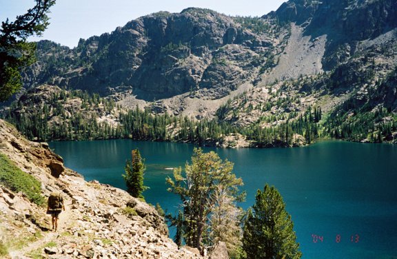
Fred Heading Down to Sheep Lake
Photos titles ending in "b" are by Bill and in "r" by Roger.
Troop 24 Kickass Trekkers: "The High Adventure Troop" Alumni Backpacking Trip -Cascade Bill Mooseker
Sign the Guestbook. Displaying 1 of 1 entries.
What a great trip! My friends and I are making the trip this August. We're planning on going counter clockwise; however your trip pictures and notes are going to be a great help to planning it. Thank you!
- Jason Day, Thu, 4 May 2006 3:51PM
Date(s): August 2004. Album by Cascade Bill. Photos by WHM/Shelby. 1 - 100 of 100 Total. 13423 Visits.
enlarge 217KB, 800x603 1 7dmapd1 Map for Day 1: Trailhead at Windy Saddle to Lower Cannon Lake - 3.7 miles and 850' climb.
enlarge 102KB, 800x533 2 7dev001 Shelby and Joel at the Windy Saddle Trailhead - We arrived at Windy Saddle in late afternoon after a long drive from the Martha Lake Community Club, with stops in Lewiston, ID for fishing licenses and lunch. This is looking south, the direction of our first days hike.
enlarge 87KB, 533x800 3 7dev002 Fred and the New Moby Dik.
enlarge 100KB, 573x800 4 7dev003 Heading out - From the trailhead (Elev 7600') ,The trail crosses a meadow before dropping sharply past a USFS Guard station (.4 mi), Silver Fir Trail (.7 mi) , and begins to contour (with ups and downs) at Bridge Creek (Elev 6660 - 1.2 miles) a drop of about 1000 feet. We were glad that we wouldn't have to climb back up at the end of the trip.
enlarge 215KB, 800x598 5 7dmapd2 Map for Day 2: Lower Cannon Lake to Dog Lake - 6 Miles & 2000' climb. Lower Cannon Lake (El 7020') to Jctn Boise Trail (El 6720') - .8 miles; Jctn to Wurl Tr (El 6640 -1.3 mi); Hansen Cr (El 6790 - 3.0 mi); Jctn Dog Lk Tr (El. 7020 - 4.9 Mi); Dog Lake (El 7910 - 6 mi) All mileages from Lower Cannon Lake.
enlarge 161KB, 800x540 6 7dev004 Fred at Lower Cannon Lake as we were heading out on our second day: - we got to the lake pretty late on our first day, reaching the Cannon Lakes Trail after the sun had gone behind the 7 Devils Crest. The Cannon Lakes Trail about 2.9 miles from the trailhead. It is about 3/4 mile with a 400' climb up to Lower Cannon Lake where we camped. There were fish jumping in the lake, but we didn't try fishing for them. The camp was in the woods to the left, with little or no views of the lake.
enlarge 118KB, 533x800 7 7dev005 Lower Cannon Lake -
enlarge 208KB, 800x540 8 7dev006 The was a big forest fire in the area in 1994 (Rapid River Fire) and the trail went through a lot of "Silver Forests" like this one, which is a little ways down the trail from the Cannon Lakes Jctn.
enlarge 112KB, 583x800 9 7dev007 Crossing a talus slope with views to the Southeast on the Boise Trail (7 Devils Loop). Another Silver Forest ahead as Fred moves on down the trail.
enlarge 152KB, 533x800 10 7dev008 Some areas of the trail were untouched by the fire and provided welcome shade.
enlarge 129KB, 533x800 11 7dev009 Fred making his way up the meadows on the Dog Lake High Route: After trudging up and down on the Boise Trail, you reach the junction with the Dog Lake High Route (About 5 miles from Lower Cannon Lake). The trail shown on the Topo map was pretty much obliterated by the 1994 fires, with the most difficult route finding near the start. Here and there are vague remnants of trail - its not too difficult to pick your way up to the lake. The most difficult part was at the end with a steep climb, dubbed "Hell Hill" by our small group.
enlarge 169KB, 800x540 12 7dev010 Our Campsite in the woods near the outlet of Dog Lake - There were a couple of more exposed camps around the east side of the lake, but we opted for this one.
enlarge 218KB, 598x800 13 7dmapd3 Map for Day 3: Dog Lake to Baldy Lake (10.5 miles - 2500' climb) Dog Lake (El 7909); Jctn 7 Devils Loop Tr (El 7030 - 1.1 mi);Horse Heaven Cr (El 7190' - 3.2 mi);Haas Cr (El 7100' - 3.8 mi); Horse Heaven Pass (El 7840' - 5.2 mi); Pyramid Mtn HP ( El 8200' - 5.9 mi);Devils Farm (El 7440' - 7.3 mi); Jct Baldy Lk Tr (El 6900' - 9.3 mi); Baldy Lake (El 7240' - 10.5 mi)
enlarge 97KB, 533x800 14 7dev011 Dog Lake - The outlet is just to the right of the picture. The peaks are the Twin Imps. We tried ar luck with the fish, but had poor luck. You had to work hard for a strike, which were few and far between.
enlarge 96KB, 533x800 15 7dev012 Cascade Bill at Dog Lake - This was just before we left camp on our third day.
enlarge 111KB, 533x800 16 7dev013 Joel and Shelby at Dog Lake.
enlarge 149KB, 800x540 17 7dev014 Joel and Fred on the shore of Dog Lake (Elev 7909'). Look at the peak above - the Twin Imps. We would see them from the other side at the end of the day. But oh!, What a long way to get there!
enlarge 110KB, 800x540 18 7dev015 Joel pauses a moment at the top of "Hell Hill" - you can see the swath the 1994 fires left in the valley below.
enlarge 125KB, 800x533 19 7dev016 Fred heading down Hell Hill - Joel and Shelby can be seen far below (2 dots) at bottom.
enlarge 122KB, 800x559 20 7dev017 Taking a break at Horse Heaven Creek.
enlarge 134KB, 800x540 21 7dev018 Joel at shoulder where the 7 Devils (Boise Trail) turns west and clumbs to Horse Heaven Pass. The peak at center is where the Horse Heaven Cabin is located.
enlarge 83KB, 800x533 22 7dev019 A view of Horse Heaven Hill (right) and the pass beyond - we did not go that way but turned north on the 7 Devils Loop Trail at Horse Heaven Pass.
enlarge 127KB, 617x800 23 7dev020 A series of steep switchbacks leads up to Horse Heaven Pass, seen here. The trail is heading away from the pass to enable the climb at a steady pace.
enlarge 97KB, 579x800 24 7dev021 Your heart is pumping along this section - just before the final switchback where the trail heads west again up to the pass.
enlarge 90KB, 800x540 25 7dev022 Taking a break at Horse Heaven pass, Shelby got this shot of these blue butterflies sitting on his hiking boots.
enlarge 118KB, 582x800 26 7dev023 Heading out of Horse Heaven pass, the trail climbs sharply before "leveling off" between 8000' and 8200'. The climb seems easier than climbing up to HH pass because of the wide views across Hells Canyon to the west.
enlarge 93KB, 533x800 27 7dev024 Meadows along the trail between HH pass and Pyramid Mtn.
enlarge 110KB, 644x800 28 7dev025 This section of the route is near the Spring shown on the Topo map. The spring is near one of the stands of "Silver Forests" shown above - There wasn't much flow but it's the only water along the trail between Dog Cr and Baldy Lake. Make sure you have enough water if you do this stretch of the trail - there was just a trickle flowing from a pipe, but it allowed me to fill a canteen for which I was very greatful.
enlarge 102KB, 584x800 29 7dev026 Looking back towards HH pass.
enlarge 114KB, 800x540 30 7dev027 Joel - Hells Canyon beyond.
enlarge 116KB, 800x540 31 7dev028 Fred along trail between Horse Heaven pass and Pyramid Mtn - I wish the whole trail was like this but we soon found ourselves descending on a rocky poorly maintained trail that was hard on your feet.
enlarge 79KB, 800x533 32 7dev029 Hells Canyon from the 7 Devils Loop.
enlarge 89KB, 800x574 33 7dev030 Fred rounding a shoulder of Pyramid Mtn with Hells Canyon beyond. We still had about 4.5 miles to go and our feet were shot by the time we go to the Baldy Lake cutoff trail.
enlarge 231KB, 800x602 34 7dmapd4 Map for Day 4: Baldy Lake to Echo Lake (4.2 mi - 1150' climb) Baldy Lake (El 7200'); Jctn 7 Devils Loop Tr (El 6900' - 1.2 mi); Baldy Cr (El 6520' - 1.9 mi); Jctn Echo Lake/ He Devil Lake Tr (El 6920' - 3.5 mi); Echo Lake (El 7250' - 4.2 mi)
enlarge 50KB, 800x533 35 1 7dev031 Baldy Lake - A very beautiful spot. Here we see the back side of the Twin Imps we had seen at Dog Lake the previous day.
enlarge 68KB, 800x533 36 7dev032 Baldy Lake - The Devils Throne towers over the lake. We tried our hads at fishing but had no luck; no strikes; and didn't see any trout rising for insects either.
enlarge 91KB, 533x800 37 7dev033 Baldy Lake is a huge alpine lake. It would be nice to spend a few days here.
enlarge 134KB, 533x800 38 7dev034 The outlet of Baldy Lake is at the right.
enlarge 143KB, 533x800 39 7dev035 Fred heading out from our camp at Baldy Lake.
enlarge 101KB, 533x800 40 7dev036 View of Baldy Lake from the outlet - very scenic.
enlarge 106KB, 533x800 41 7dev037 Looking south toward the cirque that holds Baldy Lake - the trail drops from the lake down to the valley below and then climbs back up the other side where you get this view. Potato Hill is on the right and the Twin Imps again to the left.
enlarge 68KB, 800x533 42 7dev038 Looking across Hells Canyon, you can the the Wallowa's on the horizon - We made a trip to the Eagle Cap Wilderness there in 2000.
enlarge 148KB, 800x540 43 7dev039 After a short day, which was a welcome relief from the death march the previous day, we pulled into Echo Lake. We found a nice camp on the west side of the lake. There was a large group of scouts from Pullman, Wa camped on the opposite side who were going in the opposite direction that we were. They were out trying to spear some trout for dinner. When they were hiking out, Fred gave one of the scouts a bag of Jerky to alleviate their food shortage.
enlarge 81KB, 800x533 44 7dev040 Shelby trying to catch some of the hard to catch trout in Echo Lake.
enlarge 73KB, 533x800 45 7dev041 A view across Echo Lake - You can see the Devil's Throne at the far left.
enlarge 76KB, 800x607 46 7dev042 There were some nice cutthroat trout in Echo Lake. While they ingnored the spinning lures, I was able to have some success with a a dry fly. I lost a few flies as I was used to fishing for much smaller fish.
enlarge 112KB, 800x575 47 7dev043 A nice Echo Lake Cutthroat - we had a nice fish fry.
enlarge 224KB, 624x800 48 7dmapd5 Map for Day 5: Echo Lake to Shelf Lake - 5.7 miles and 1050' climb: Echo Lake (El 7250); Jct 7 Devils Loop (El 6900 - 1.5 mi); Little Granite Cr (El 7200 - 1.4 mi - good water); Hibbs Cow Camp (El 7360' - 1.8 mi - good water); Jctn Dry Diggens LO Tr (El 7580 - 2.1 mi); Jctn Sheep Lake Tr (El 7400 - 3 mi); Basin Lake (El 7390 - 5.3 mi); Shelf Lake (El 7450 - 5.7 Mi)
enlarge 104KB, 522x800 49 7dev044 Looking back towards the basin that holds Echo Lake - framed by He Devil Mtn on the left and the Devil's Throne on the Right.
enlarge 95KB, 800x554 50 7dev045 A good view of Hells Canyon.
enlarge 132KB, 553x800 51 7dev046 A wooded meadow between Echo Lake and Hibbs Cow Camp - this was just before a small stream with good water - first water since Baldy Cr. There was also good water at a spring at Hibbs Cow Camp.
enlarge 143KB, 800x522 52 7dev047 Just beyond Hibbs Cow Camp and before the Dry Diggens LO Trail, I saw some of these Lillies. I took a picture as I had never seen them before - I think that it is a Sego Lily.
enlarge 164KB, 800x522 53 7dev048 Another show of a pair of Sego Lillies.
enlarge 122KB, 522x800 54 7dev049 Shelby and Fred in a light hearted moment at the Jctn of the Dry Diggens LO trail.
enlarge 113KB, 581x800 55 7dev050 Just beyond the Dry Diggens LO trail Jctn, the trail goes over a meadowed high spot (El 7600') and begins a gradual descent to the Sheep Lake Trail.
enlarge 105KB, 800x522 56 7dev052 On our descent down to the Sheep Lake Trail.
enlarge 108KB, 800x540 57 7dev051 Shelf Lake - We had a nice camp here. We met a couple of Horsemen at the lake - a Dad and his son who were taking a break from their work as trail builders (they had a company that bid on trail restoration). We had a nice talk with them.
enlarge 150KB, 800x545 58 7dev053 Joel, Shelby, and Fred - ready to head out from Shelf Lake. There were a lot of fish in Shelf Lake - the only problem was that they were all less than 5 inches long! The other drawback was that you had to drop over a 100 foot from the Sheep Lake trail to the lake.
enlarge 136KB, 800x522 59 7dev054 Shelby, Joel, and Bill at Shelf Lake.
enlarge 265KB, 800x734 60 7dmapd6 Map for Day 6: Shelf Lake to Sheep Lake - 2.1 mi & 900' climb Shelf Lake (El 7450); Gem Lake Tr (El 7720 - .4 Mi); He Devil Pass (El 8300' - 1.2 mi); Sheep Lake (El 7890 - 2.1 mi)
enlarge 82KB, 522x800 61 7dev055 Climbing to the divide to Sheep Lake, you pass this impressive rock formation.
enlarge 125KB, 557x800 62 7dev056 Fred heading up the trail to Sheep Lake - the snow fields are on the flanks of He Devil (at left).
enlarge 151KB, 522x800 63 7dev057 Looking back down the trail from near the divide.
enlarge 123KB, 522x800 64 7dev058 Fred at the divide I call He Devil Pass (El 8300')
enlarge 109KB, 522x800 65 7dev059 Finally we get a view of beautiful Sheep Lake.
enlarge 109KB, 522x800 66 7dev060 Fred at viewpoint of Sheep Lake.
enlarge 154KB, 522x800 67 7dev061 There are a lot of switchbacks for the descent to Sheep Lake, but the views are with you the whole way.
enlarge 146KB, 800x522 68 7dev062 Fred making his way down.
enlarge 134KB, 800x522 69 7dev063 We were planning on taking the climbers route out to the cars - from here we thought the route went up the talus slope to the right. If you look closely you can see a path through the talus up to the pass above. The actual route is much less steem and goes up a ledge around to the pass at the left of the picture. It could be that the route up the talus is a climbers route up the Tower of Babel.
enlarge 117KB, 522x800 70 7dev064 He Devil from the Trail.
enlarge 116KB, 570x800 71 7dev065 The Tower of Babel - I tried casting a lure for quite a while but had no luck. On our way out the following day, we met a couple coming in for the weekend. The guy said that one of his friends had caught a very large trout in the lake and had carried it out in a garbage bag filled with ice. Maybe that explains the lack of fish - the big one had eaten up all the others.
enlarge 139KB, 540x800 72 7dev066 Talus at the foot of He Devil - Joel on rock in foreground shows the scale.
enlarge 119KB, 540x800 73 7dev067 Meadow camp at Sheep Lake - you can still see Joel on the rock to the right. The pot in the foreground is Shelby's squirrel trap. He Devil is in the background.
enlarge 180KB, 800x540 74 7dev068 Talus and snowfield on She Devil - there is also a Mountain goat at the center, but it is standing in front of the snow field so it is hard to see. (zoom picture to original size to find it).
enlarge 153KB, 800x540 75 7dev069 Here the goat is more visible as it stands on a rock face.
enlarge 89KB, 800x540 76 7dev070 Alpenglow on Sheep Lake as the sun sets.
enlarge 112KB, 566x800 77 7dev071 Alpenglow on the Tower of Babel.
enlarge 99KB, 540x800 78 7dev072 Joel's tent in the foreground with the Tower of Babel beyond.
enlarge 90KB, 800x522 79 7dev073 We had a nice camp fire at Sheep Lake.
enlarge 269KB, 719x800 80 7dmapd7 Map for Day 7: Sheep Lake to Trailhead at Seven Devils Lake CG - 2.3 mi & 650' climb. Sheep Lake (El 7890); Goat Pass (El 8500' - 1.2 mi); 7 Devils Lake CG (El 7600' - 2.3 mi)
enlarge 127KB, 522x800 81 7dev074 After making your way around the east shore of Sheep Lake, you have to go up this very steep talus slope.
enlarge 80KB, 522x800 82 7dev075 After climbing up the talus slope you reach a 10' - 15' ledge that you follow up. Looking back you get this view of Sheep Lake and the images of He Devil and its reflection in Sheep Lake. "Love the pictures you posted. This is all familiar gr..." View Comments...
enlarge 89KB, 540x800 83 7dev076 She Devil is to the left.
enlarge 89KB, 568x800 84 1 7dev077 Another view of Sheep Lake from the climbers route back to the trailhead. The reflection is from the ponds north of Sheep Lake proper - at high water it would be all one lake.
enlarge 207KB, 540x800 85 7dev077 Here, Bill is making his way up the talus slope.
enlarge 110KB, 540x800 86 7dev078 Fred going up the ledge.
enlarge 117KB, 568x800 87 1 7dev080 Another view of Fred going up the ledge.
enlarge 109KB, 800x540 88 7dev079 Nearing the top, the trail contours around to the pass - here Joel takes in the view.
enlarge 156KB, 568x800 89 7dev086 Charlotte at Goat Pass : We met Charlotte at Sheep Lake - She caught up to me just before Goat Pass. She and her friend had camped at Sheep Lake.
enlarge 113KB, 540x800 90 7dev080 Charlotte and Fred : You can see Joel on top of the rock beyond.
enlarge 75KB, 800x568 91 7dev083 Looking west from Goat Pass - the Devil's Tooth is in the foreground. You can see the 7 Devils Trail as it crosses the talus beyond the Devil's tooth.
enlarge 90KB, 800x568 92 7dev084 Bill at Goat Pass.
enlarge 103KB, 568x800 93 7dev085 Joel and Shelby fooling around at Goat Pass.
enlarge 112KB, 568x800 95 7dev088 Joel - he's come a long way since he punctured my butt pad on our hike to Navaho Pass way back in 1998. (See 1998 Hikes)
enlarge 146KB, 568x800 96 7dev089 The Tower of Babel from the north - Mirror Lake is at bottom left.
enlarge 94KB, 800x568 97 7dev090 Last Pass - Fred, Shelby, and Joel. - You can see the Windy Pass Trailhead in the saddle at the road junctions below. We still had quite a descent from here.
enlarge 110KB, 800x591 98 7dev091 Bill, Fred, Shelby, and Joel.
enlarge 169KB, 622x800 99 7dev092 Fred and Joel are really moving down the steep slope - by the time I got down there they were long gone and I didn't see them till I got to the trailhead.
enlarge 167KB, 526x800 100 7dmap Map showing the entire 7 Devils Loop - Best Viewed at Original Size.